WeatherTiger's 2024 Hurricane Season Review
Looking back on a high-flying hurricane season that really blew the doors off.
This is the last of the 141 (!!) updates I have written during the 2024 hurricane season. I hope WeatherTiger’s forecasts helped you stay cool through the year’s many tropical challenges.
To celebrate the merciful end of the 2024 season, I’m offering record savings of 24% off new annual subscriptions through 12/31. Supporters get exclusive daily briefings, in-depth video forecasts, landfall liveblogs, real-time seasonal outlooks, and the ability to ask questions and post comments for the entire 2025 hurricane season, all for our lowest-ever price of $38/year.
Also, paid supporters receive exclusive monthly newsletters through the off-season featuring WeatherTiger’s 3-month temperature and precipitation forecast for Florida, 6-month El Nino/La Nina modeling, and the latest news and notes from around the weather world. The December 12th newsletter will have a supporters-only forecast of 2025 hurricane season odds.
Thank you again for reading WeatherTiger’s Hurricane Watch this season.
In retrospect, perhaps it was a bad omen that the skies turned blood red across the world a few weeks before hurricane season began. Because just as eclipses, solar flares, aurorae, and comets danced across the heavens in 2024, so too did hurricane landfalls rain down on the U.S. like so many doors falling from a Boeing 737 MAX 9.
The 2024 hurricane season, foreseen as an impending disaster due to hot-to-go Atlantic ocean temperatures and a shear-reducing La Nina pattern, lived up to the hype with two major hurricane landfalls in Florida. As a one-two punch on the continental U.S, Helene and Milton rank second only to Harvey and Irma as the most destructive duo of hurricanes in a single year.
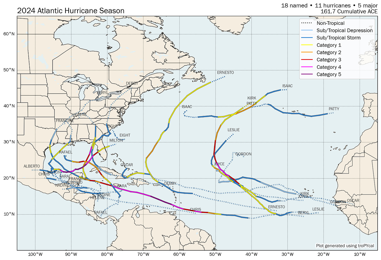
But the capricious 2024 season also defied expectations at every turn. Often, it spiraled upwards like Nvidia stock, with ferocious storms turning and turning in widening Central American Gyres at unusual times. Others, it plunged like Boeing stock, quietly whittling away the traditional peak of hurricane season.
Straight from the tortured meteorologists department, here is WeatherTiger’s anthology of 2024 tropical activity. You might say it really blew the doors off.
June
The first month of hurricane season brought a couple of warm-up Central American Gyres, one of which caused significant flooding in South Florida without attaining a name. Persistent ridging over the Deep South during the second half of June trapped both Tropical Storms Alberto and Chris in the southwestern Gulf, just as a faulty Boeing spacecraft has trapped two astronauts in space for six months.
July
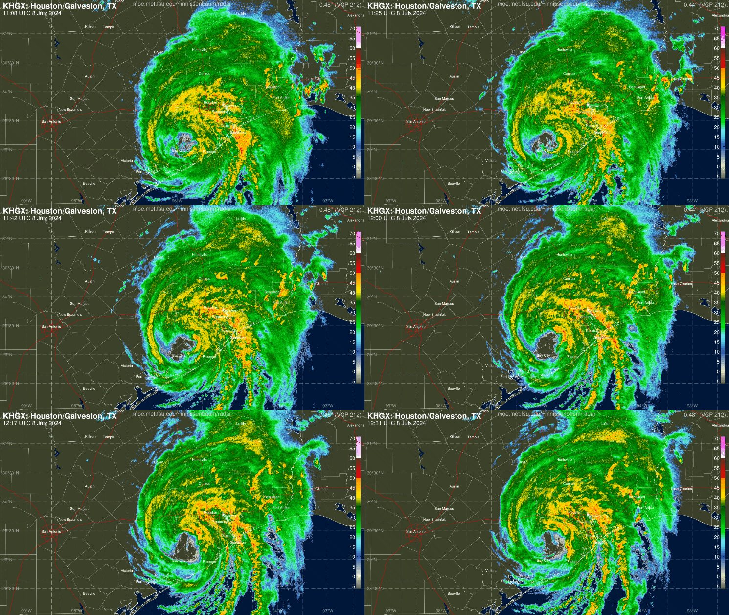
Beryl was one of the worst July hurricanes of all time, with a track and intensity far more typical of August or September. Rapidly developing east of the Lesser Antilles, Beryl became the strongest-ever June hurricane before ripping through the Caribbean between the 1st and 5th. Peaking as a Category 5 with sustained winds of 165 mph (tied for highest in July), Beryl struck the Yucatan peninsula, then made the first U.S. hurricane landfall of 2024 in southeastern Texas with wind gusts over 80 mph, including in Houston.
Hurricane season was offline the rest of July, possibly due to being hosted by CrowdStrike.
August
While the rest of 2024 vacillated between hyperactive and quiet periods with the aplomb of Dr. Raygun’s spasmodic breakdancing, August was the sole month to wind up near average.
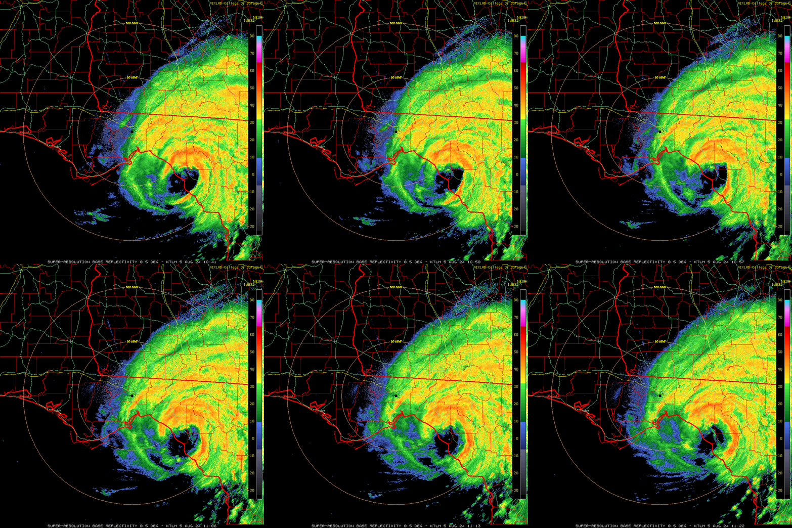
Cat 1 Hurricane Debby, the forgotten middle child of Taylor County, Florida’s three landfalls in thirteen months, epitomized brat aesthetic as it re-enacted Idalia’s track into Steinhatchee on the 4th, minus a couple of categories of intensity. Debby brought peak Gulf Coast surge of 5’ or more, plus widespread flooding caused by 8-15” of rain from west-central Florida to the eastern Panhandle into southern South Carolina. Hurricane Ernesto also winged Puerto Rico and Bermuda with tropical-storm-force winds and heavy rain mid-month.
September
And then there were none. Between August 20th and September 9th, zero storms occurred for the first time since 1968, as high wind shear and dry air ate their way across the Atlantic like a worm through a brain. That is significant, as around 30% of historical Atlantic hurricane activity occurs in that typically busy three-week period.
But just as Red Lobster’s Endless Shrimp deal was too beautiful for this world (sic transit gloria scampi), so too was our brief, unexpected reprieve from tropical tribulation. Category 2 Hurricane Francine overperformed on final approach to south-central Louisiana on the 11th, and Gordon, Isaac, Joyce, and Category 4 Kirk belatedly brought the season back to life and back to reality in the open waters of the eastern Atlantic in the second half of the month.
But that’s not what you remember about September. Developing from a gargantuan Central American Gyre on September 24th, Hurricane Helene threaded the Yucatan Channel on the 25th and raced northeast across the eastern Gulf on the 26th as it rapidly intensified to Category 4 strength. With tropical-storm-force sustained winds extending nearly 350 miles southeast of the center, Helene raked the Florida peninsula’s Gulf Coast with damaging gusts and deadly surge as it passed over 100 miles west of Tampa, with the worst coastal impacts again reserved for the Big Bend. Helene was the first-ever Category 4 hurricane to make landfall in Apalachee Bay, obliterating coastal towns in Dixie and Taylor Counties with 15’ or more of storm surge and winds likely exceeding 120 mph.
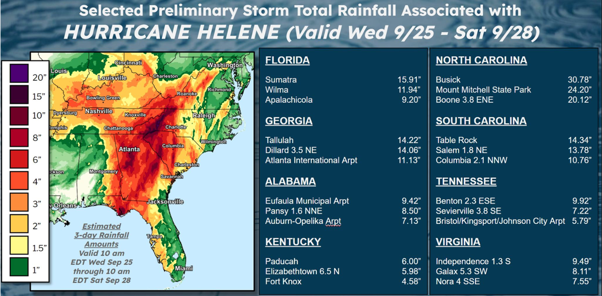
Bolting inland at 30 mph, Helene’s catastrophic impacts extended deep into the Southeast, with winds of 100 mph reaching as far north as Augusta and elevated pockets of western North Carolina. As that atmospheric river of moisture slammed into the southern Appalachians, the mountains wrung out a 15-30” deluge of rainfall, causing the worst flooding in eastern Tennessee and western North Carolina since at least 1916. Tragically, these landscape-altering flash floods made Helene the second-deadliest hurricane of the 21st Century, trailing only Katrina.
October
The punishment continued in October, as only a few days post-Helene yet another Central American Gyre drifted into the western Gulf, this time Hoovering up a depression from the eastern Pacific. Milton’s unusual means of storm development were just the start, leading to one of the most anomalous track and intensity combinations in hurricane climatology.
Milton’s transformation from a minimal tropical storm to a Category 5 hurricane in just 48 hours is a photo finish with 2005’s Wilma for fastest rapid intensification in history. Tied for highest sustained winds ever in the Gulf, Milton is a top five all-time Atlantic hurricane in terms of minimum surface pressure, estimated to be 897 millibars. Fun fact, that is lower than the cabin pressure of a 737 MAX 9 flying at 3000’ after all its doors have fallen off!1
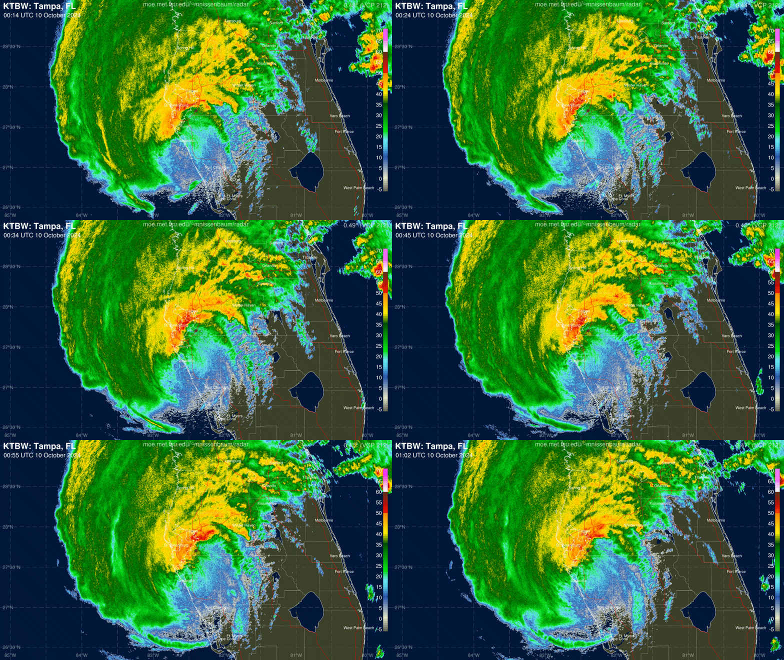
Rather than a typical path north or northeast, Milton initially moved due east across the Gulf, putting the vulnerable west-central Florida coastline in the crosshairs of a major hurricane. Milton turned northeast and began to weaken as it interacted with a front on approach to Florida on the 9th. This reduced maximum sustained winds at landfall near Sarasota to an estimated 120 mph, still strong enough to notch the first Category 3 or higher landfall between Cedar Key and Charlotte Harbor since 1921.
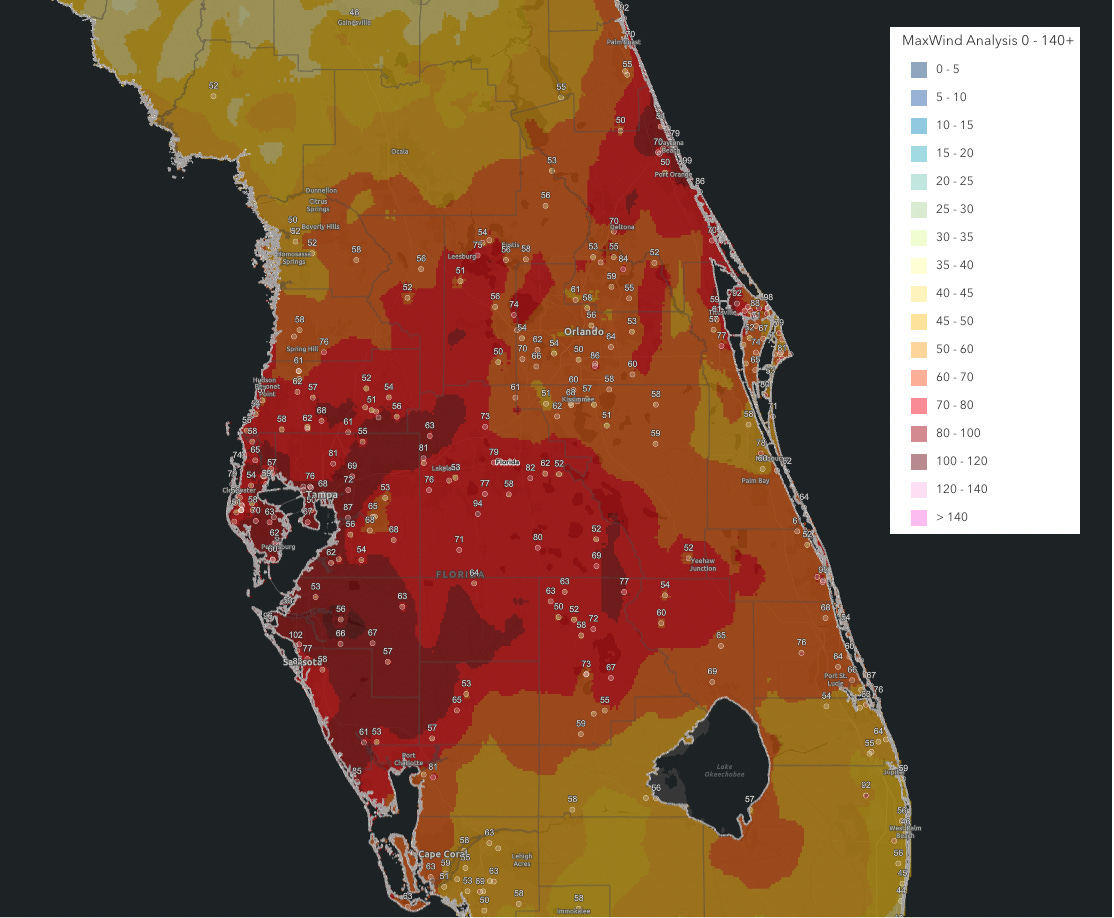
Storm surge of 5-10’ devastated portions of the Southwest Florida coast left untouched by Ian’s inundation, while hurricane-force wind gusts and extensive flooding from 10-15” rainfall totals racked the I-4 corridor. Wind damage was particularly severe in Pinellas County and vicinity, where 100+ mph gusts hammered areas still reeling from Helene, and Southeast Florida saw extreme localized damage from an outbreak of over 40 tornadoes. The destruction is still being tallied, but Milton may be the second-costliest hurricane in Florida history when all is said and done, lagging only Ian.
Elsewhere, Leslie followed a meandering path in the open Atlantic, Nadine brought heavy rain to Central America, and tiny Hurricane Oscar launched a surprise blitz on eastern Cuba.
November
Like the song that never ends, the 2024 hurricane season just went on and on, my friends. November’s three storms tripled average activity for the month, with cool-down Central American Gyres spawning Rafael and Sara. Both kept Floridians as nervous as someone seated in the exit row of a 737 MAX, but in the end caused few U.S. impacts, despite Category 3 Rafael tying the record for strongest November hurricane in the Gulf of Mexico.
WeatherTiger’s Final Thoughts
In one sense, 2024 was a predictable hurricane season. WeatherTiger’s August forecast was for around twice the total activity of a normal year, with four to five U.S. hurricane landfalls. Total activity came in a little above 160% of normal: a hyperactive season, though also a bit below expectations. Unfortunately, 2024 was indeed punctuated by five U.S. hurricane landfalls, a threshold met nine times since 1900.
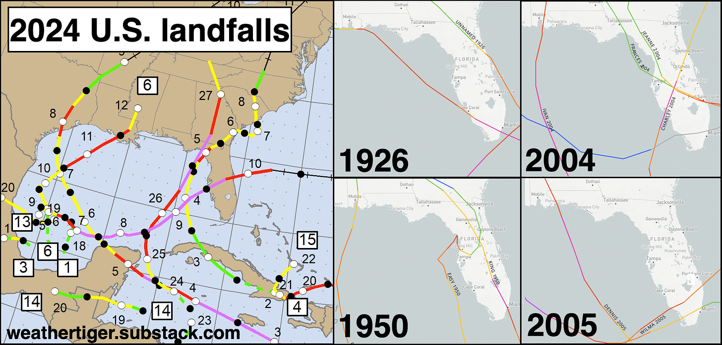
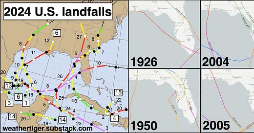
Helene and Milton, the 14th case of two or more U.S. major hurricane landfalls in a single season in the last 125 years, were also fifth and sixth major hurricanes to hit Florida’s Gulf Coast since 2017. This was just the fifth hurricane season with two Category 3 or higher landfalls in the state, joining 1926, 1950, 2004, and 2005 as years which will live in infamy. The 13 days between Category 4 Hurricane Helene and Category 3 Milton are also the shortest time on record between consecutive major hurricane landfalls in Florida.2
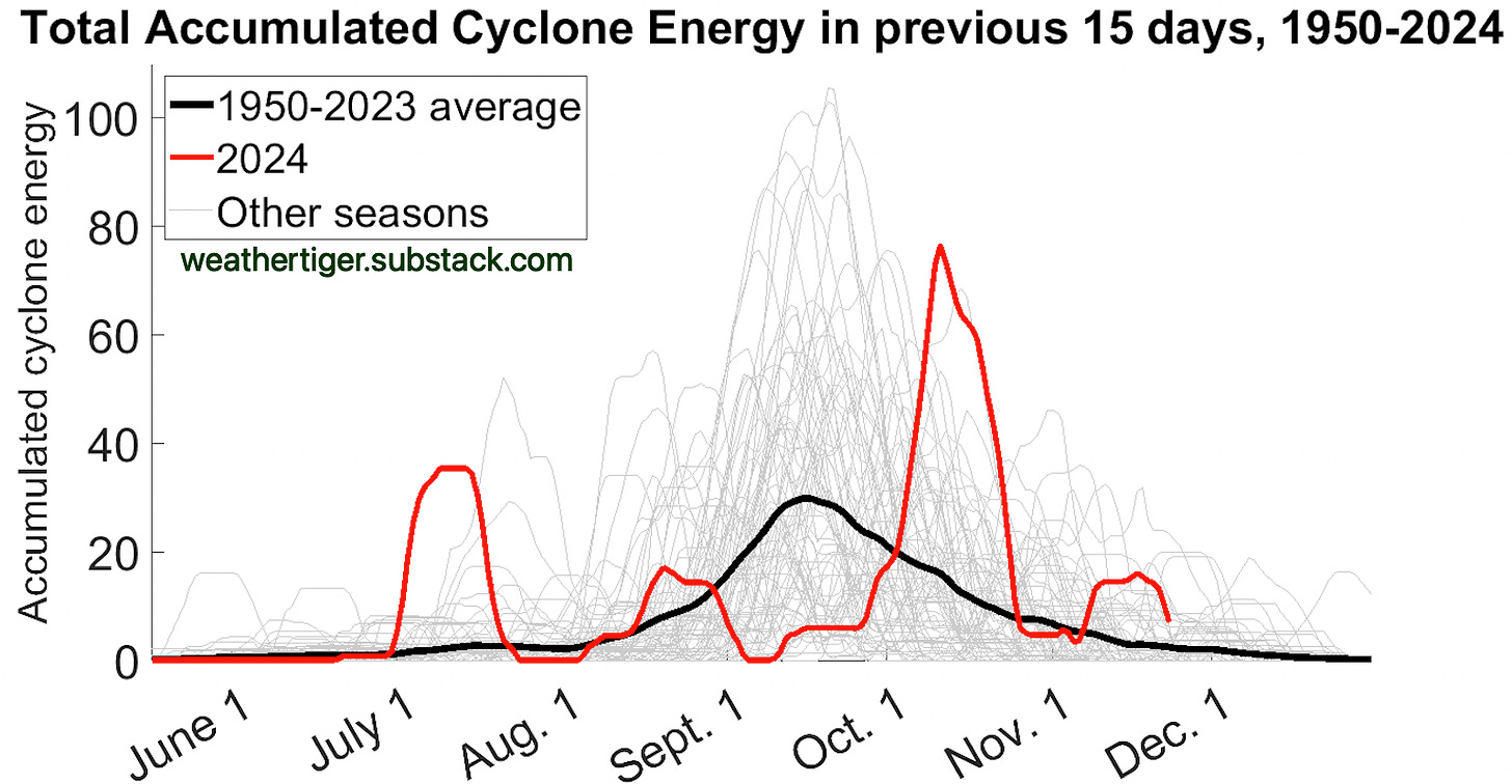
However, the way 2024 attained hyperactivity was downright bizarre. Hurricane seasons are always chunky, with storm tracks clustering in time and space. This year, not only did hurricanes cluster in the eastern Gulf of Mexico, leading to around $200 billion in total damage, but when storms developed had little regard for hurricane history. Typically, storm activity peaks between late August and mid-September; this year, that timeframe was the quietest it has ever been since 1950, while early July and early October were the most active those periods have been in 75 years. Rather than a typical bell curve, the plot of tropical activity this year looks like an EKG, befitting an infarction of a hurricane season.
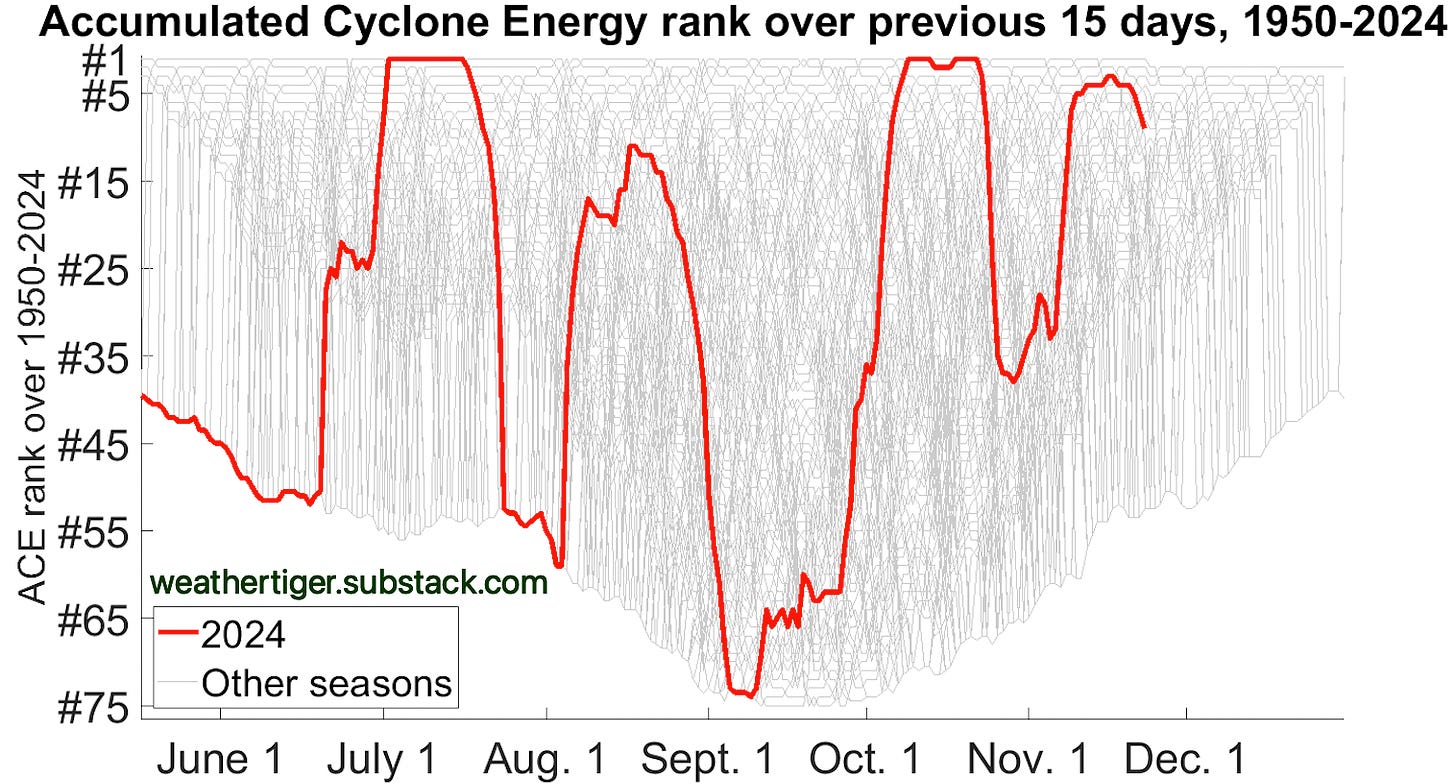
In absolute terms, 2024 was by far the swingiest hurricane season on record since 1950. Theories as to why this was, like the strange northward shift in the track of tropical waves in August and September, abound. There’s no clear answer yet, making it difficult to say whether 2024 is a one-off or heralds future shifts in when and where storms are favored to develop. Hurricane scientists, like Boeing engineers, have a lot of work to do to try to figure out what went wrong this year. We’re working on it.
And so, after 141 forecasts in 2024, I’m finally signing off. Floridians, congratulations on surviving the most brutal hurricane season in two decades, and take some comfort in knowing it could have been worse. Milton might have gashed Tampa with 12’ of surge, not just destructive winds and flash flooding. Tallahassee’s annual tradition of gazing into the abyss and the abyss blinking at the decisive moment continued. Florida state parks weren’t actually replaced with Infiniti dealerships.
And of course, worst of all, you could be reading this from a 737 Mad Max. Until next time, keep watching the skies.
Quite literally true! Here’s a calculator you can play around with.
Shortest time between two different storms making landfall. The 1926 Great Miami Hurricane made landfall near Pensacola as a Cat 3 two days after crossing South Florida.




Hey:
I just want to Thank You for all your help during the Hurricane Season-which was a terrible one this year for sure! I live in Sarasota so got really hit hard. Also was in Highlands NC for Helene which was really frightening. I depend on your guidance and your sense of humor to get thru these events. You make it doable! Happy Thanksgiving to you and your family-and the Tiger Cub! Best, Margaret Pennington.
Grateful for your knowledge & ability to convey it in such a wonderful way!!
Happy Thanksgiving to you & your family!!