Hurricane Francine Morning Briefing for September 11th
Francine is on track to strike Louisiana as a hurricane today. Here's what's changed overnight.
Sign up for WeatherTiger’s hurricane forecast newsletter by clicking here:
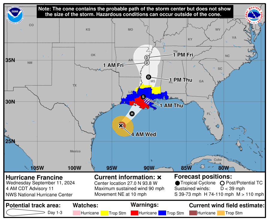
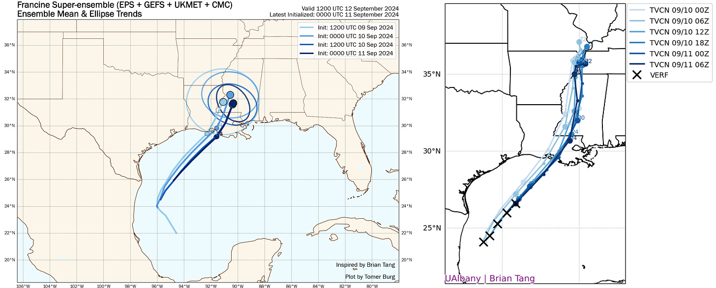
Francine has intensified to a strong Category 1 hurricane overnight with sustained winds of 90 mph while moving northeast across the western Gulf of Mexico, with modest changes in its expected path overnight. The official NHC track is still for a landfall in eastern Vermillion Bay in south-central Louisiana, meaning Francine will bring dangerous surge and wind over much of south-central and southeastern Louisiana, and will likely track close enough to Baton Rouge and New Orleans to cause tree-damaging wind impacts.
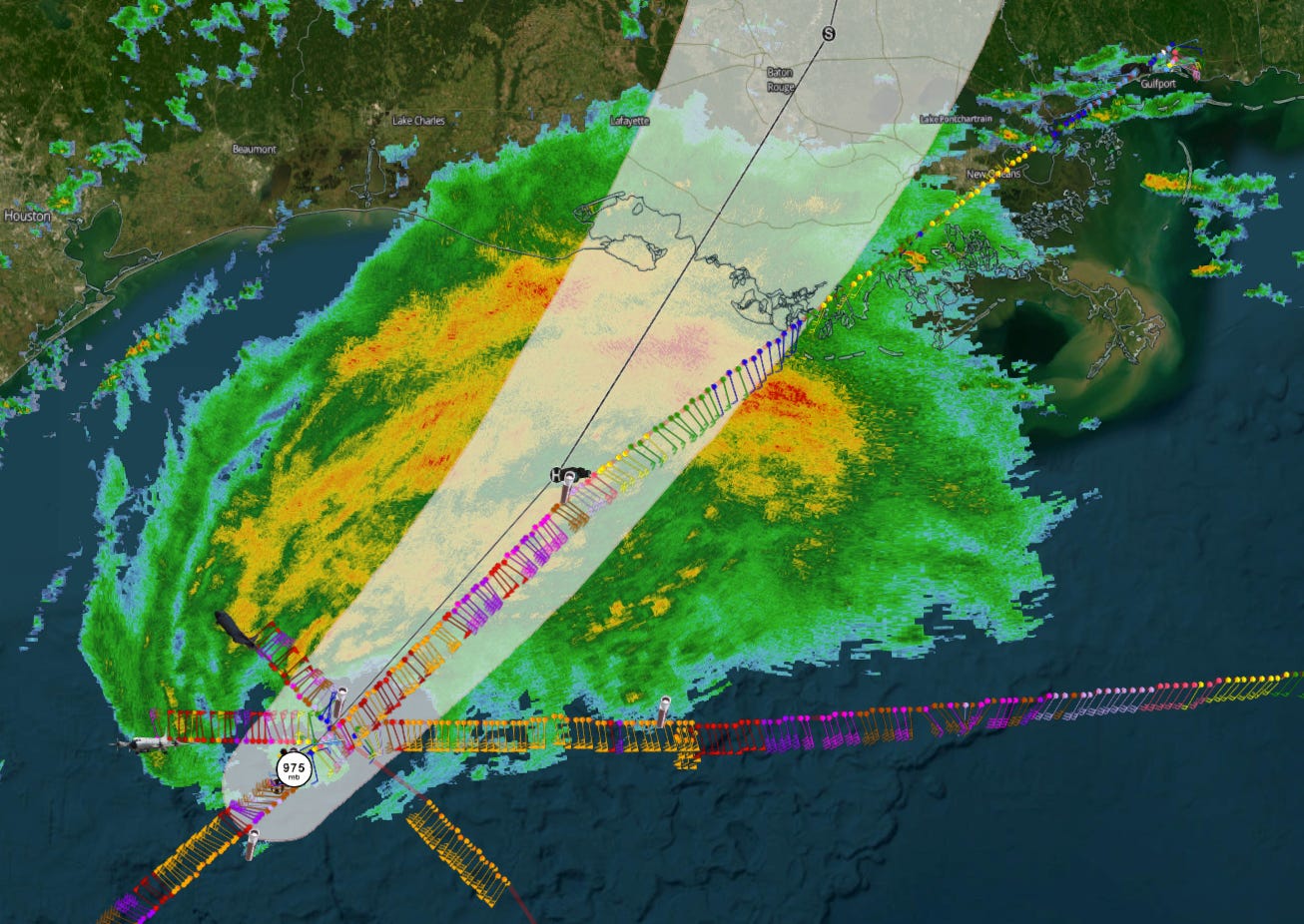
As of the NHC’s 8 a.m. intermediate advisory, Hurricane Francine is located about 195 miles southwest of Morgan City, LA, moving northeast at about 12 mph. That puts Francine’s center a little less than 175 miles from the coastline, meaning landfall is likely sometime this evening. Francine’s movement this morning is a little east of the 5 a.m. NHC forecast track, and has bent more to the northeast overnight. Ongoing Hurricane Hunter flights show that Francine’s vortex is tilted to the northeast going up in the atmosphere due to increasing shear as the hurricane moves further north; this was expected, but the interaction with a trough to the hurricane’s north is enhancing Francine for now, with pressures falling between recon center passes.
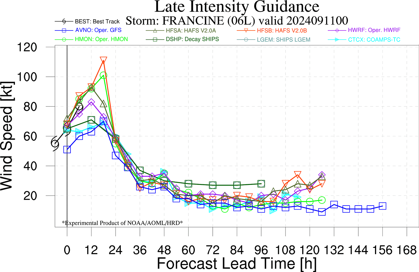
Maximum sustained winds have increased to 90 mph. Overnight, the NHC intensity nudged the expected peak intensity up to 100 mph, a Category 2 hurricane. Overall, hurricane intensity models show intensification may continue through the morning, but most guidance including the new 06Z HAFS runs suggests plateauing or a little weakening from peak intensity by landfall as even stronger shear from the southwest further displaces Francine’s low- and mid-level centers.
Another change to be aware of this morning is that the NHC track forecast has nudged ever so slightly east, and the 5 a.m. advisory track brings Francine to the coastline somewhere south of Morgan City this evening between 6 and 10 p.m. Overnight model guidance on the whole has not changed much and is zeroing in on eastern Vermillion Bay, followed by a track between Baton Rouge and New Orleans overnight into early Thursday and a turn north tomorrow up the Mississippi River.
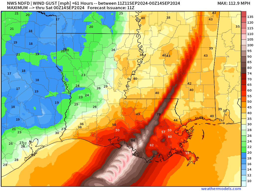
My thoughts on impacts haven’t changed all that much from what I laid out yesterday. Winds are always sensitive to the exact track of the core of the storm, but at this point path uncertainty is winnowing down to the point that the major cities of eastern Louisiana will very likely see damaging impacts. The latest wind risk product from the NWS highlights that all of the south-central Louisiana coastal plains is at high risk of seeing hurricane-force wind gusts, including Morgan City and Houma. High-end tropical-storm force gusts (55+ mph) are probable in Baton Rouge, Lafayette, and New Orleans. Lower-end tropical-storm-force wind gusts will also be felt well inland into southern Mississippi and east along the Gulf Coast to Pensacola in squalls.
Life-threatening storm surge of 5-10’ is now the peak range in Vermillion Bay, and 4-7’ is also possible east to the mouth of the Mississippi River. Surge is expected to be 2-4’ and locally higher over much of the rest of the Central Gulf Coast, all the way east to the Alabama/Florida line. The area of highest surge danger is between roughly south of Houma to Morgan City. Don’t expect much in the way of surge action west of Vermillion Bay due to offshore winds.
Another major threat from Francine is flash flooding. While Francine will be moving about 15 mph at landfall, heavy rainfall is already beginning this morning in southern Louisiana as expected and another 4-8” is probable in the next 24 hours, on top of similar accumulations in the past week. This adds up to a significant risk of flash flooding tonight into early tomorrow for eastern Louisiana and southern Mississippi, including New Orleans, and more localized risks elsewhere in Mississippi, Alabama, and North Florida. These risks are unchanged from yesterday.
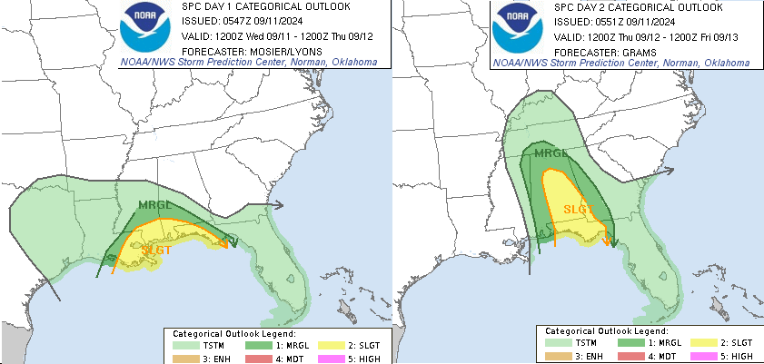
Finally, one notable change to the impacts forecast from yesterday is an expansion of the Storm Prediction Center’s region of “slight” (level 2/5) tornado risks in Alabama and North Florida on Thursday, which have been bumped up a category yesterday for Tallahassee and surrounding areas. The strong shear that will weaken Francine at landfall and transition it to an extratropical cyclone as it moves inland will also create favorable conditions for tornadoes to develop east of the circulation center, from eastern Louisiana into the western Panhandle later today and then in Alabama and North Florida tomorrow. There is a risk of quick-developing tornadoes embedded in periodic bands and cells well east of the path of the storm, so have a way of receiving weather warnings along the Central Gulf Coast east into the Florida Panhandle for the next few days.
Back this afternoon with a quick check on Francine and a more typical daily update on the rest of the potential activity in the Atlantic. Stay safe!


![[Image of cumulative wind history] [Image of cumulative wind history]](https://substackcdn.com/image/fetch/w_1456,c_limit,f_auto,q_auto:good,fl_progressive:steep/https%3A%2F%2Fsubstack-post-media.s3.amazonaws.com%2Fpublic%2Fimages%2F14af34a5-a80a-493f-853a-baa8c27e13d5_897x736.png)
![[Image of WPC Flash Flooding/Excessive Rainfall Outlook] [Image of WPC Flash Flooding/Excessive Rainfall Outlook]](https://substackcdn.com/image/fetch/w_1456,c_limit,f_auto,q_auto:good,fl_lossy/https%3A%2F%2Fsubstack-post-media.s3.amazonaws.com%2Fpublic%2Fimages%2F7387ec8a-ba6a-4f70-a243-118001c5ea21_1090x692.gif)
