WeatherTiger's Hurricane Helene Landfall Live Blog [Final Post: 1:00 a.m.]
Tracking Helene moment-by-moment into landfall, live from Southeast Tallahassee.
Our Hurricane Helene landfall liveblog has concluded. We hope you found our coverage valuable as you dealt with this historic storm. If you enjoyed this liveblog, sign up to receive our newsletter by clicking the link below.
Thanks for reading and hope you stayed safe.
1:00a: NHC update and goodnight
The 1 a.m. hourly update from the NHC has Helene as a Category 2 hurricane, with sustained winds of 110 mph, sprinting north-northeast at 26 mph. All remaining Extreme Wind Warnings have been cancelled as Helene slowly weakens.
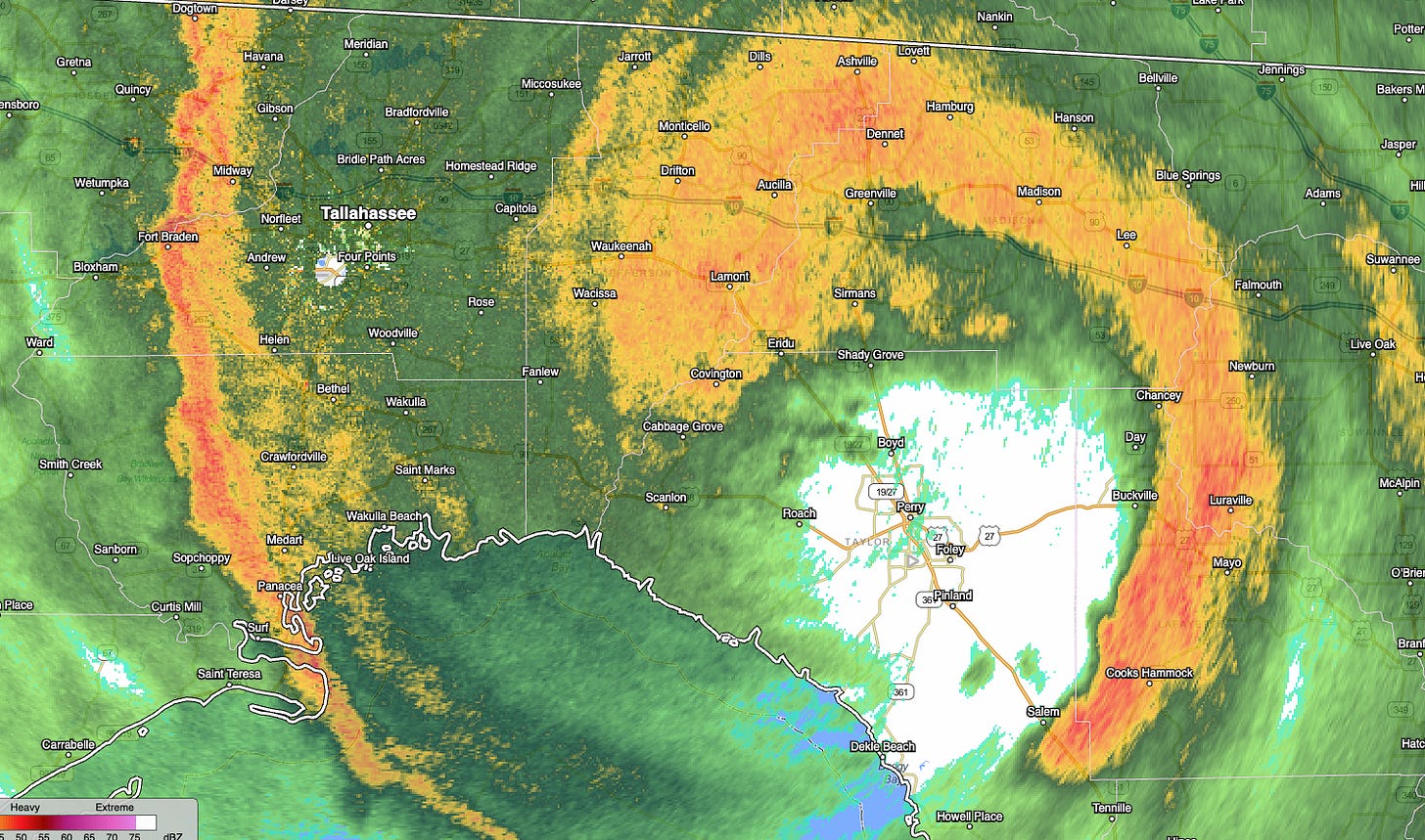
Still, even over 60 miles inland and nearly two hours post-landfall, the eastern eyewall of Helene is still formidable, and is a major inland wind threat for south-central, southwest, and central Georgia through the overnight hours. In North Florida, winds and rain are winding down as a final band passes through Tallahassee. Expect just intermittent showers and gusty conditions through the morning hours. Peak gust at the Tallahassee airport seemed to have been 67 mph, with higher numbers likely in eastern Leon County.
With that, I’m concluding the liveblog with an equal mixture of relief, exhaustion, and extreme confusion as to how Taylor County can be hit three times by hurricanes (including two major hurricanes) in 13 months, after having exactly one other hurricane landfall on record in 170+ years.
In any case, I hope you stayed safe through this terrifying storm threat and found some value in WeatherTiger’s coverage. Goodnight.
12:30a: Eyewall pushing into Georgia
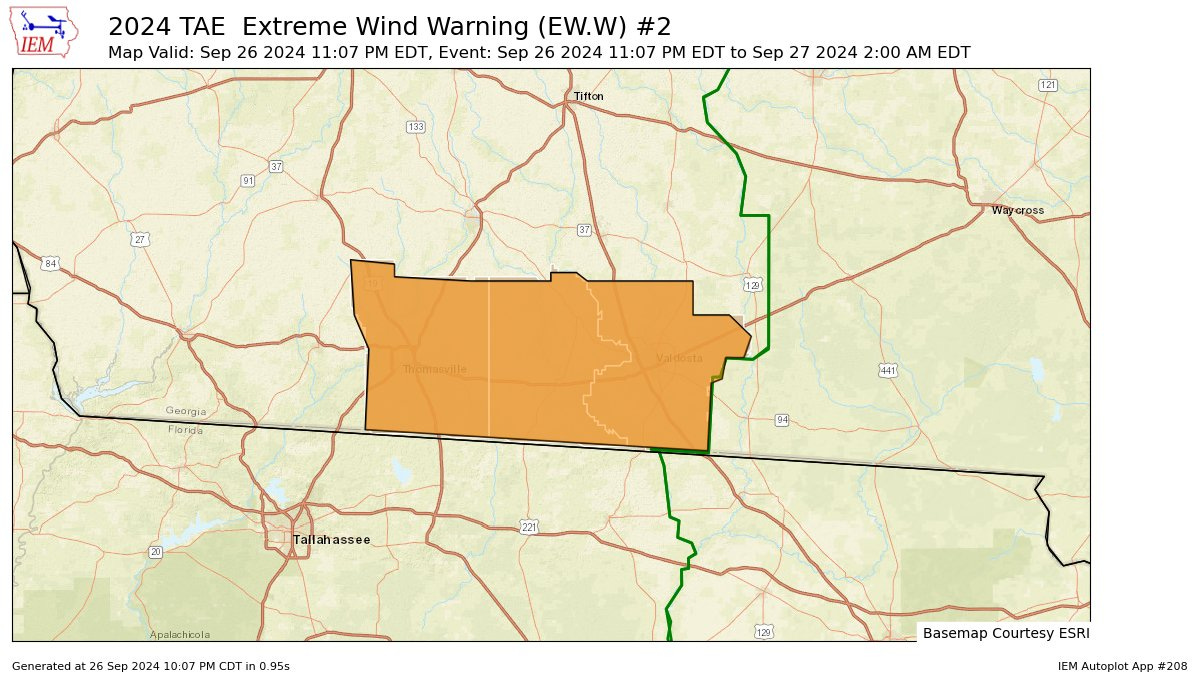
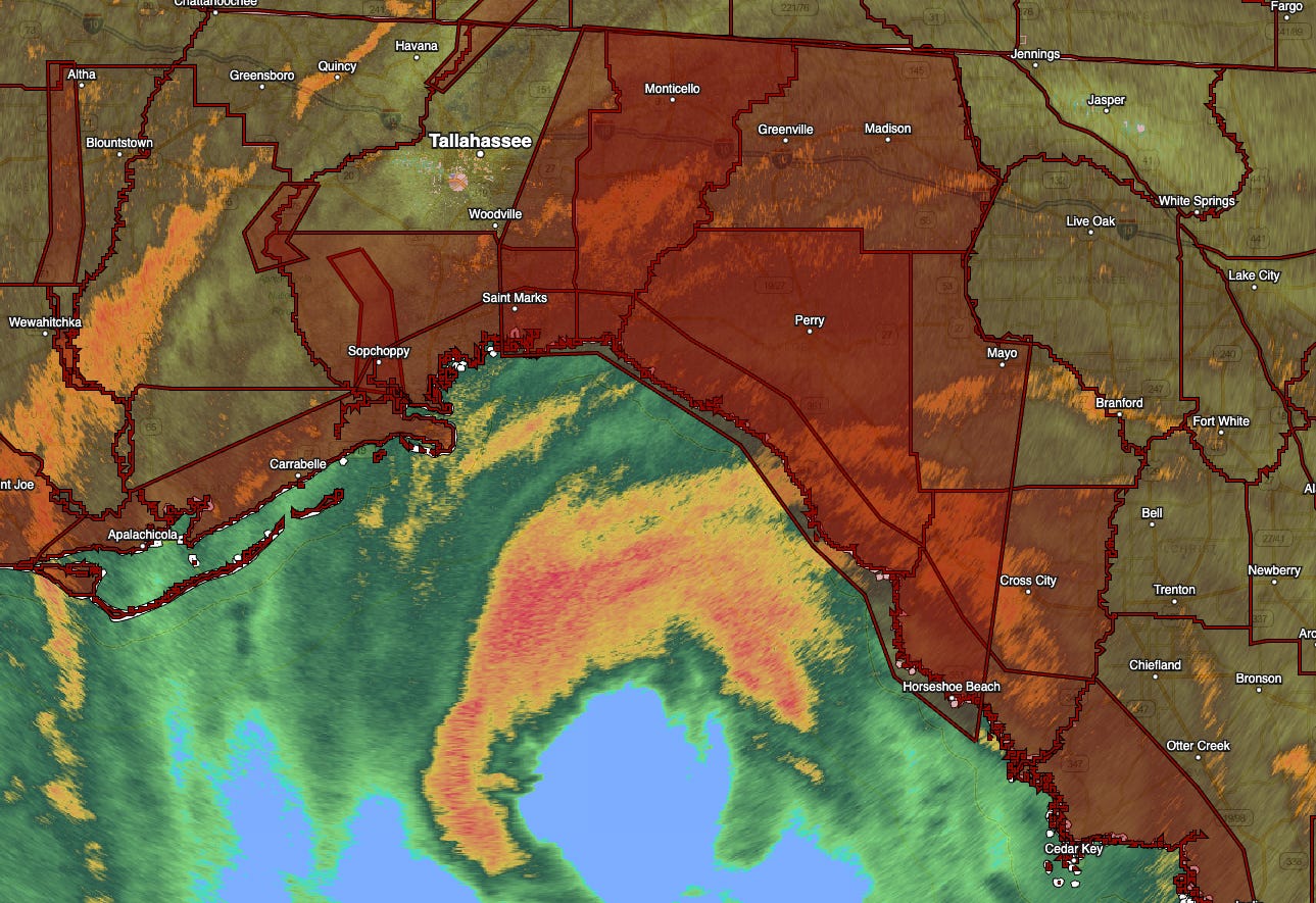
The northern eyewall of Helene is racing north at over 30 mph into south Georgia, with the worst conditions arriving in Valdosta now. With the center of the hurricane just north of Madison, Extreme Wind Warnings indicating the potential for 115 mph or higher gusts continue between Live Oak and Monticello.
Winds are still cranking in Tallahassee as well, where the airport just clocked a 67 mph gust. One final strong band is about to roll through town from the west, which may actually produce our top wind gusts in town in the next 30 to 45 minutes.
One final post to wrap it up coming up at 1 a.m.
11:55p: Closest passage to Tallahassee
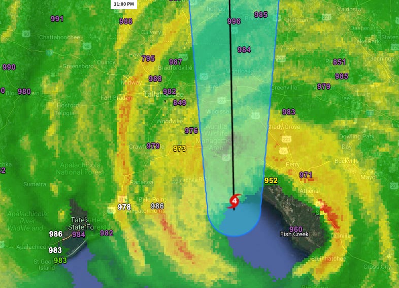
The center of Helene is now just north-northwest of Perry, where wind gusts of 99 mph were recorded at the airport. Helene is making its closest approach to Tallahassee now, passing about 40 miles east-southeast of the Capitol. Pressure is now also slowly rising at WeatherTiger World HQ in southeast Tallahassee, where a minimum of 973 millibars was record.
The top gust so far at Tallahassee Airport is 60 mph, though I would not be surprised to see higher gusts when a strong band to the city’s west rolls through in the next hour.
11:35p: New Extreme Wind Warning
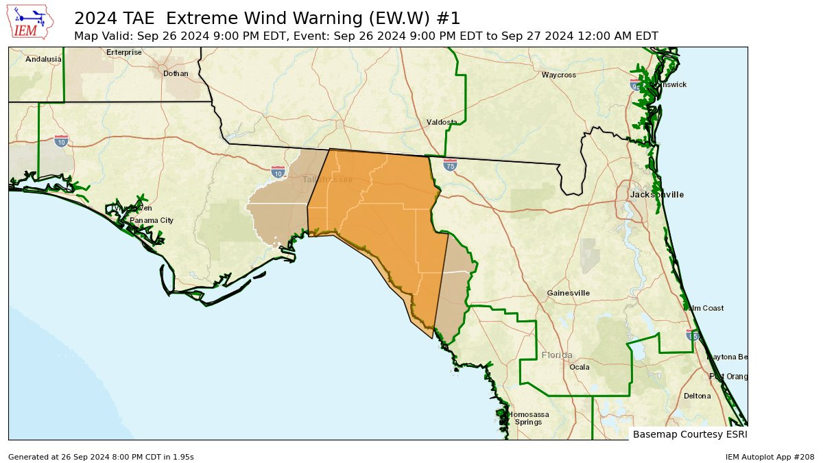
NWS Tallahassee has extended the Extreme Wind Warning north into Brooks, Lowndes, and Thomas Counties until 2 a.m. Time to take interior shelter in these areas.
Eye is over Perry now, where pressure as of the last report was 948 millibars. The worst conditions will continue in the Capital Region for another hour and a half, gradually easing after 1 a.m.
11:20p: Official landfall and historical perspective
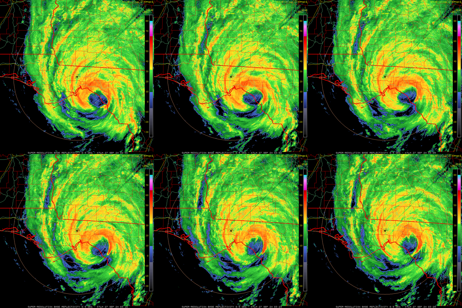
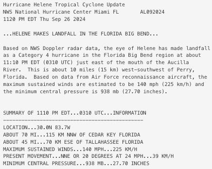
Hurricane Helene has made landfall on the Big Bend coastline as of 11:10 p.m, 10 miles west-southwest of Perry. Maximum sustained winds at landfall were 140 mph, a Category 4 hurricane on the Saffir-Simpson Hurricane Wind Scale.
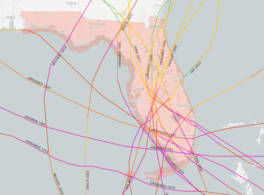
Helene is now the 17th Category 4 hurricane to make landfall in Florida since 1851. It is also the only Category 4 or 5 hurricane on record to make landfall between Panama City (Michael) and Charlotte Harbor (Ian/Charley).
11:05p: New advisory, eyewall pushing inland
The 11 p.m. NHC advisory leaves the imminent landfall intensity at 140 mph, squarely a Category 4 hurricane. Within minutes, Helene will become the first ever Category 4 hurricane to make landfall in Apalachee Bay since at least the 1840s. The hurricane continues to move north-northeast, now at 24 mph.
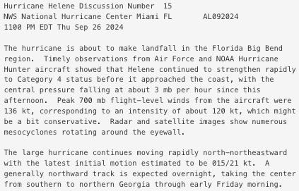
The NHC discussion highlights mesocyclones rotating around Helene’s eyewall, which are smaller circulations within the inner core that can cause damage streaks and locally elevated wind gusts. Continue sheltering in an interior location in the Extreme Wind Warning and surrounding areas, as the worst of Helene starts now in Leon County.
10:45p: Worst weather imminent in Big Bend
Helene’s core has expanded slightly to about 60-65 miles wide as it nears landfall. The center of the hurricane is only about 15 miles offshore, and landfall will occur in the next half-hour in western Taylor County.
The worst weather is occurring now in Alligator Point, St Marks, and Perry, and will be starting in the next hour from south to north across Leon County. Top wind gust so far at Tallahassee Airport is 49 mph, and winds should rise further soon.
10:30p: Wind and surge observations
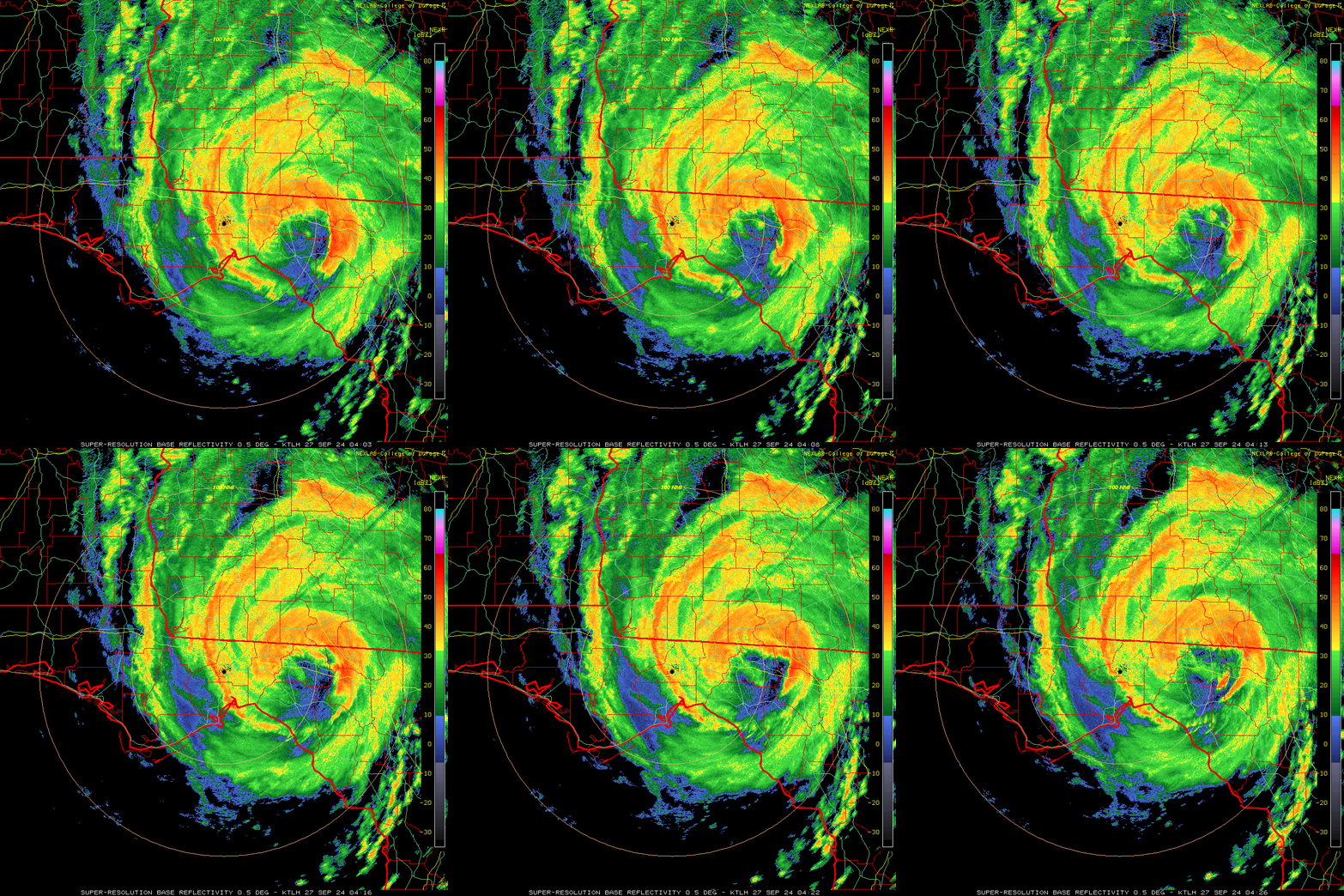
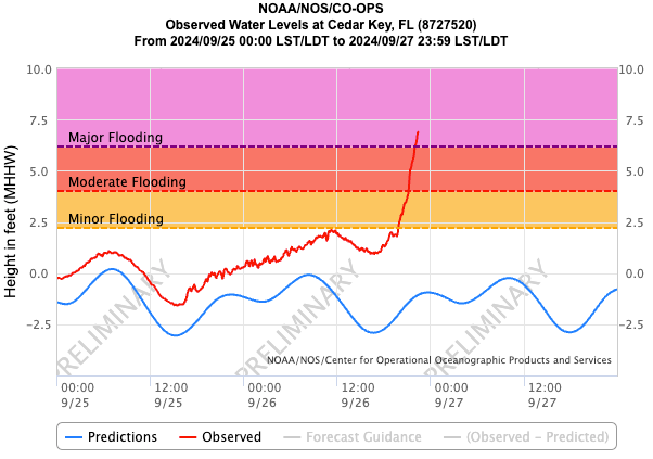
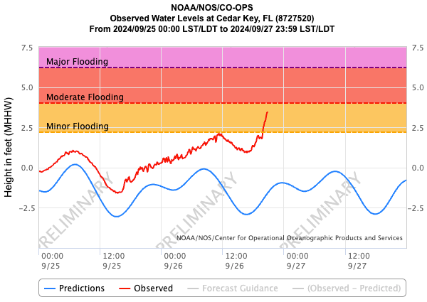
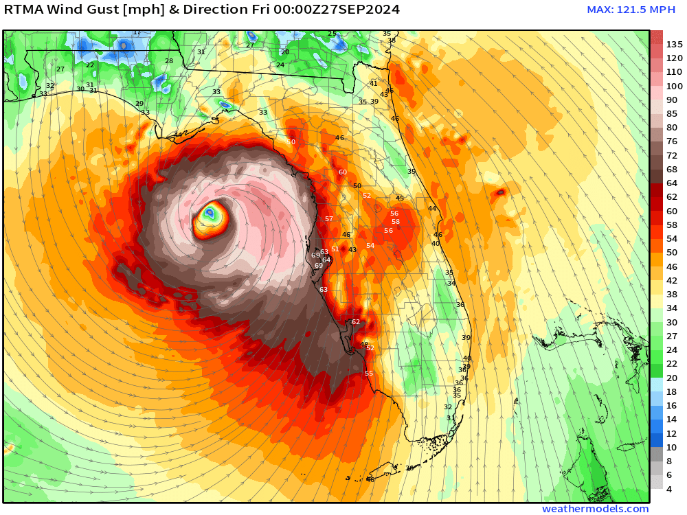
Helene is bringing all the havoc of a Category 4 landfall to Apalachee Bay tonight. The worst of Helene’s eastern eyewall is moving towards Perry, as Cedar Key storm surge is soaring past major flood stage. While wind observations are few and far between in the Big Bend, the top gust in to NWS Tallahassee so far is 84 mph at Horseshoe Beach. With winds above the surface over Taylor County as estimated by Doppler radar of 150 mph or more, you can bet much worse is happening now.
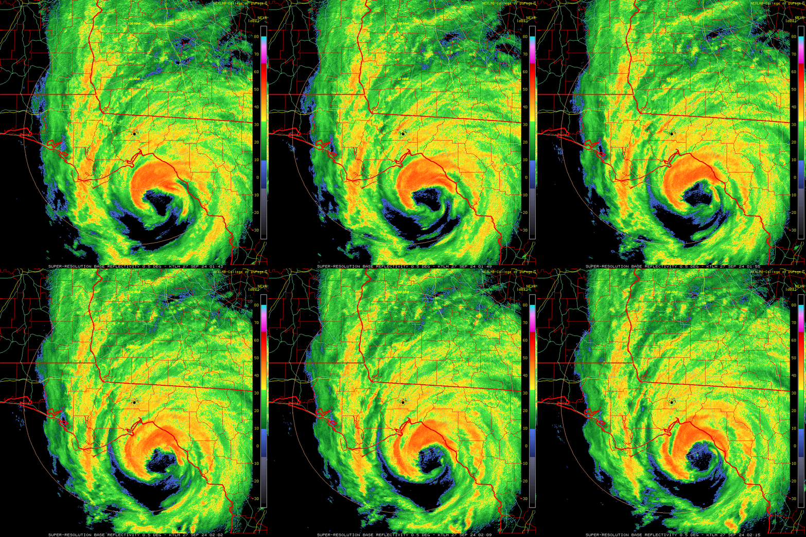
10:20p: Eyewall on shore
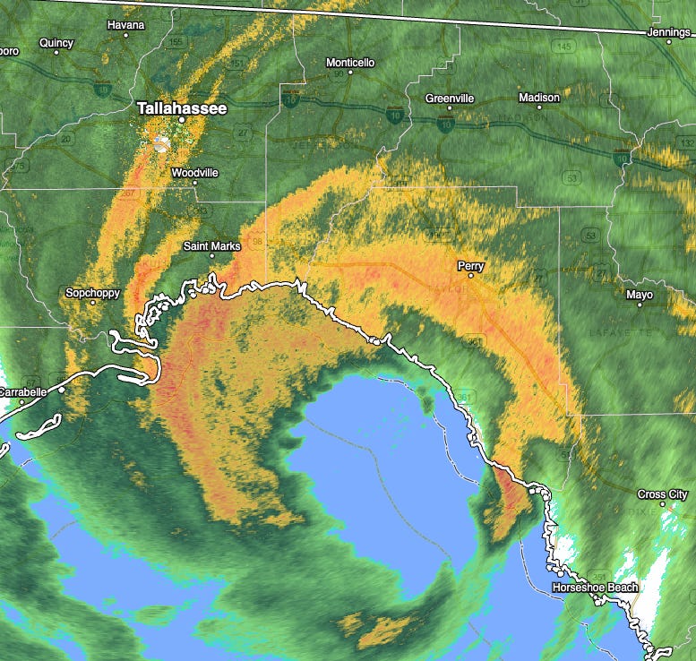
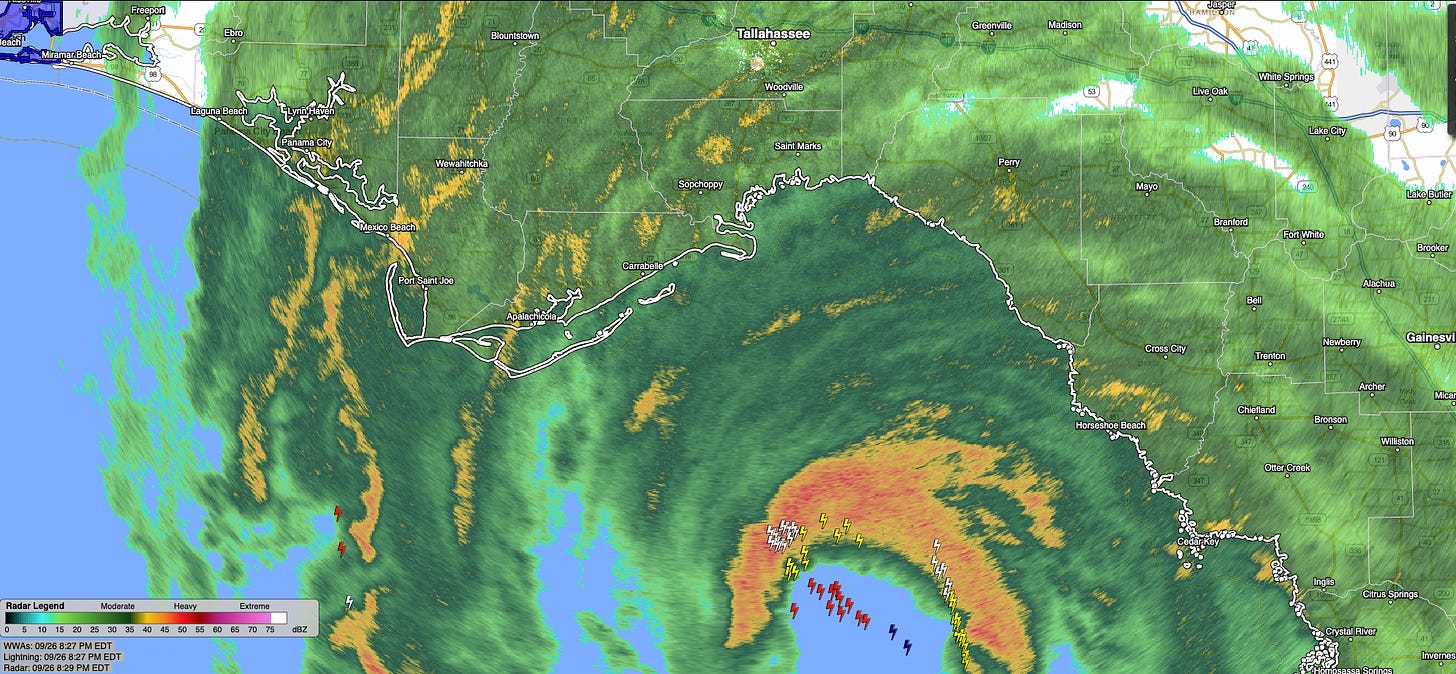
Helene’s most intense eastern eyewall is on the Taylor County coast as of 10:15 a.m., with landfall less than an hour away. The eyewall is also moving into Jefferson and western Wakulla Counties now.
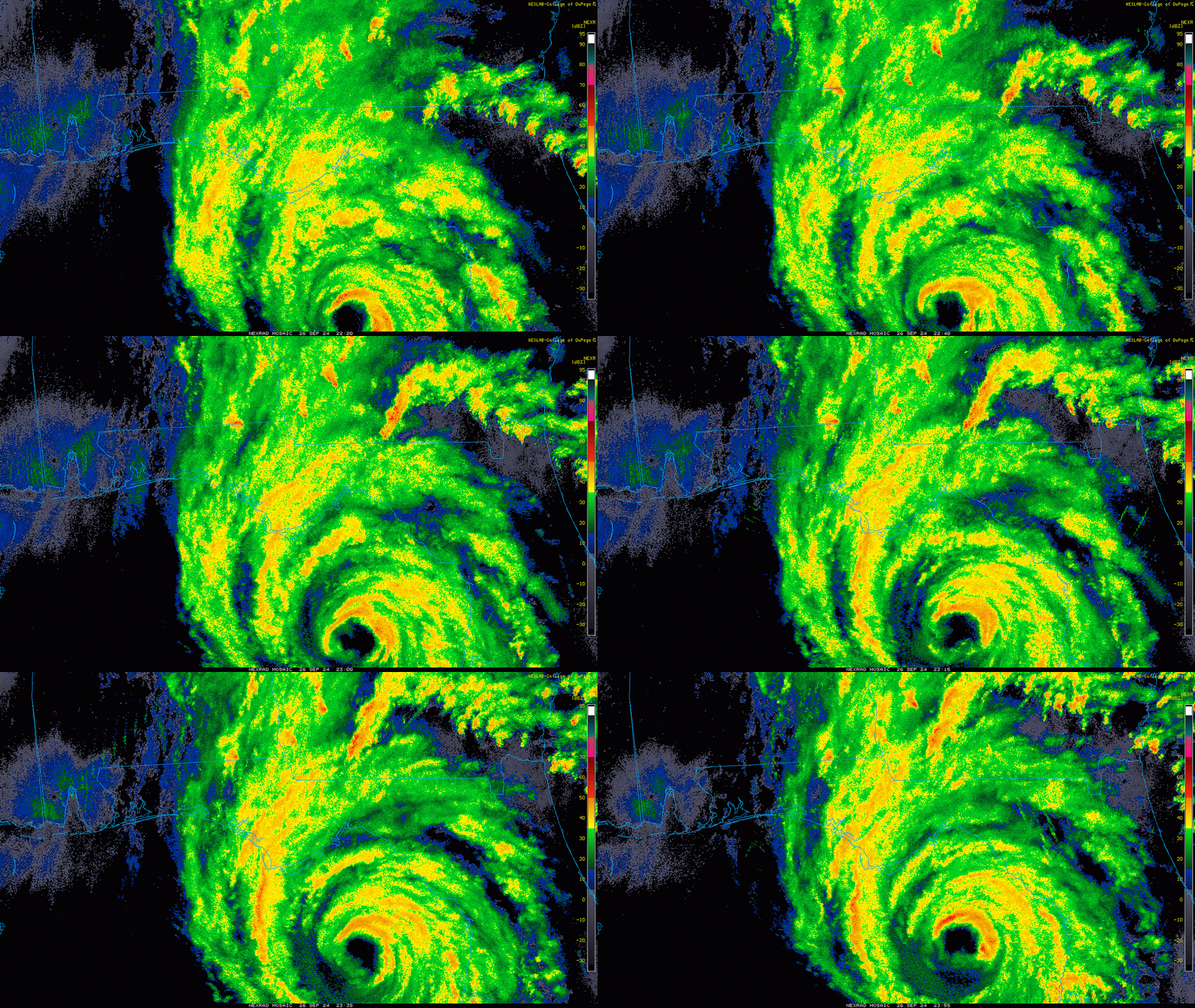
With strong convection on the western half of the storm, the inner eyewall is periodically expanding northwest. While not all of Leon County is under the Extreme Wind Warning, just to be on the safe side, I would take shelter now in Tallahassee as if you were in case wobbles or core expansion bring the strongest winds a bit farther west.
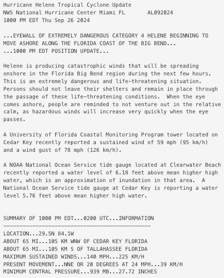
10:05p: NHC 10 p.m. update
The hourly position estimate from the NHC places Category 4 Helene about 65 miles south of Tallahassee, with sustained winds of 140 mph. Movement has tilted a touch back to the north, now moving north-northeast on a 20 degree heading at 24 mph. Minimum central pressure is down to 939 millibars.
Still strengthening.
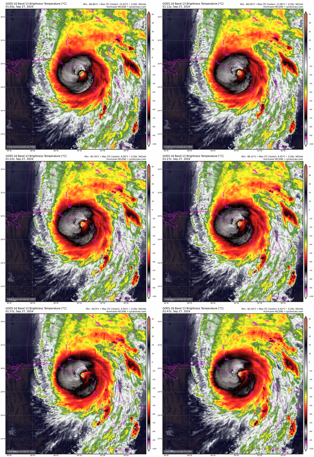
9:55p: Convective burst continues
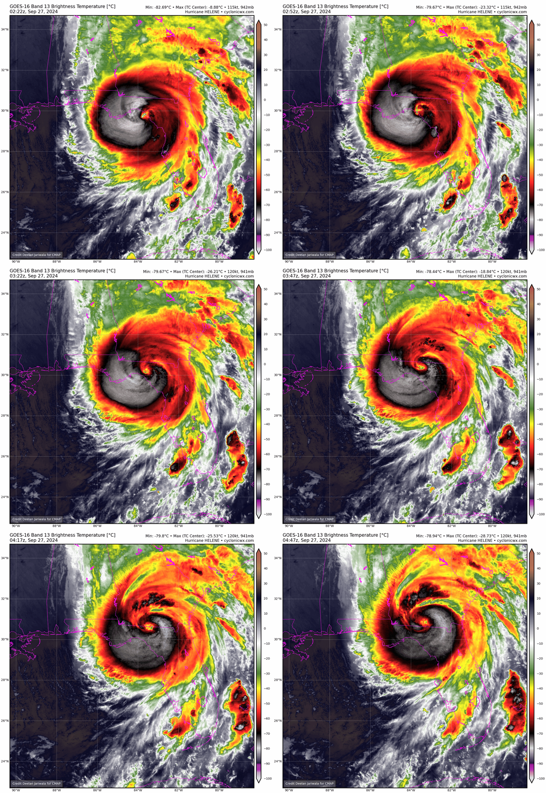
Infrared satellite imagery is showing extremely intense convection continuing to burst on the western and northwestern side of Helene’s center of circulation, with embedded lightning. Hurricane Hunters are finding pressure continuing to drop on each pass, now in the upper 930s.
All in all, Helene appears to be continuing to strengthen all the way to landfall, which is likely about an hour away in western Taylor County.
9:45p: Flash Flood Warnings across Panhandle
In addition to the Extreme Wind Warning, almost all of the Central and Panhandle are also under a Flash Flood Warning due to torrential rain associated with Helene’s core. This warning lasts until 3:15 a.m., so in case there already wasn’t reason enough, be sheltered and stay sheltered until tomorrow morning across the Panhandle and Big Bend.
9:35p: Eyewall nearing shore
The northern portion of Helene’s inner eyewall is just about onshore in Taylor County. With the Extreme Wind Warning beginning just miles east of Tallahassee, there is no closer shave possible for the Capital Region. Hurricane-force wind gusts are still likely in Tallahassee, and we will have to watch closely for any possible track wobbles or core expansion that would bring the very dangerous eyewall over more of Leon County.
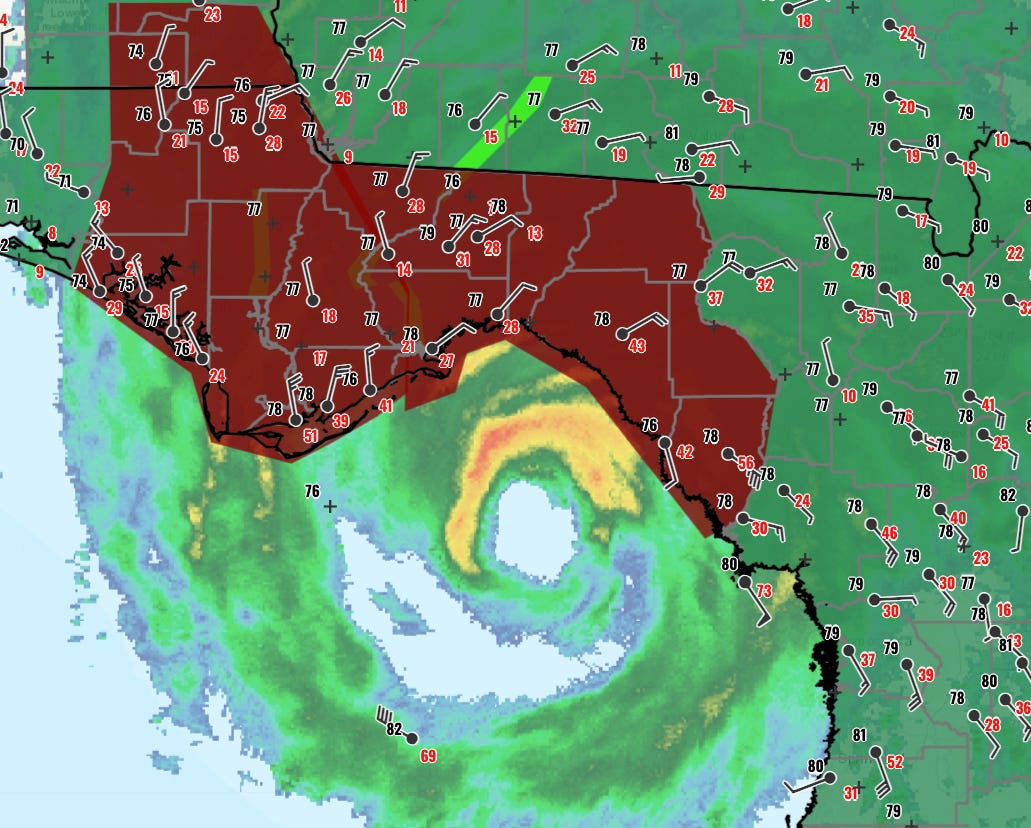
9:20p: Extreme Wind Warning issued
The Tallahassee National Weather Service office has issued an Extreme Wind Warning for portions of eastern Leon, eastern Wakulla, Jefferson, Taylor, Madison, western Lafayette, and western Dixie Counties. This is an extremely rare warning issued when non-tornadic winds exceeding 115 mph are possible in a location. Treat this warning, which lasts until midnight, as you would a Tornado Warning, and seek shelter in an interior room. If you have large overhanging trees and are on the east side of the storm, you choose a room on the north side of your house if you do not have a strong interior room in which to shelter.
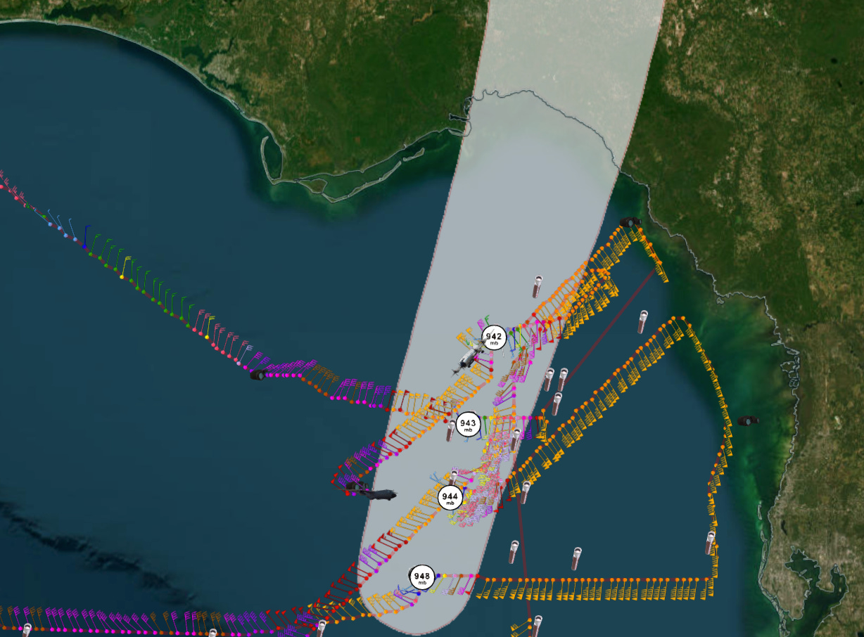
With two Hurricane Hunters circling Helene, lots of data is coming in telling us about the strength of the hurricane’s winds and its motion, allowing forecasters to issue a timely warning. This movement has been quite steady over the past three hours, with Helene tracking north-northeast at about a 15 degree heading and its forward speed accelerating above 25 mph. On this track, Helene’s inner eyewall will reach the coast in the next hour or so, followed by landfall around 11 p.m. in western Taylor County. If there are no major changes in heading or the size of Helene, the inner core will tuck into the Extreme Wind Warning area.
9:00p: Helene intensifies further
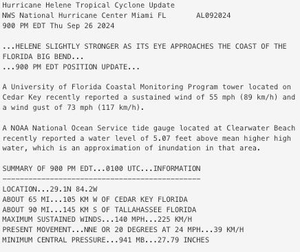
The hourly position and intensity estimate from the NHC finds Helene an even stronger Category 4 hurricane based on reconnaissance data. Maximum sustained winds are up another 5 knots to 140 mph.
Even as Helene passes 65 miles west of Cedar Key, winds there are nearly gusting to hurricane force at 73 mph. The worst conditions in the inner eyewall remain offshore for now.
8:50p: Surge rising quickly
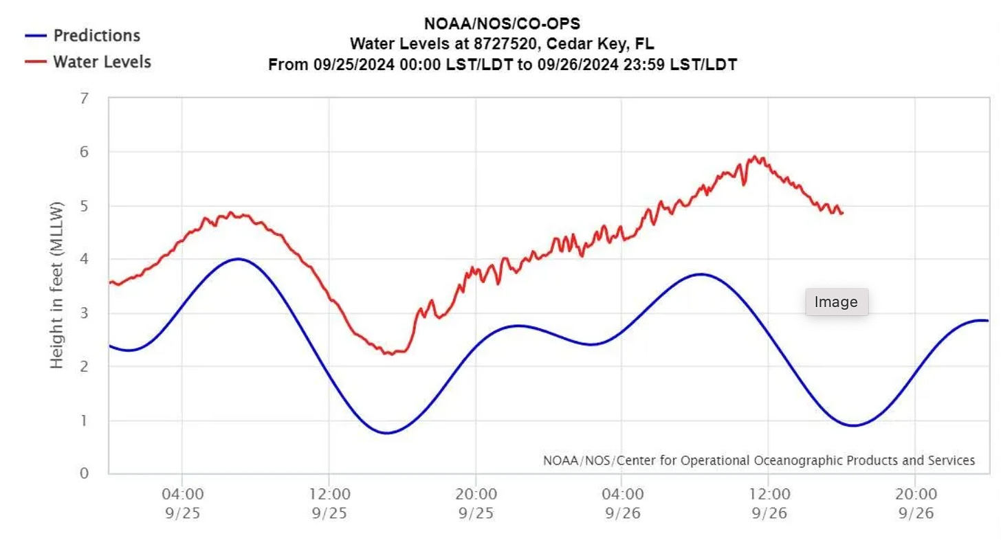
Floodwaters are rising quickly as the tides and storm surge are combining to begin a historical inundation of central and eastern Apalachee Bay.
At Cedar Key, surge is already about 5’ above baseline values and rising fast.
8:30p: Eyewall real talk
The center of Hurricane Helene is now about 75 miles south-southwest of the Taylor County coastline, with the leading edge of Helene’s inner eyewall only about 35 miles offshore Horseshoe Beach in Dixie County. As of 8:25pm, this inner core is shaping up to be about 55 miles wide. That could change with time, perhaps broadening a bit prior to landfall.
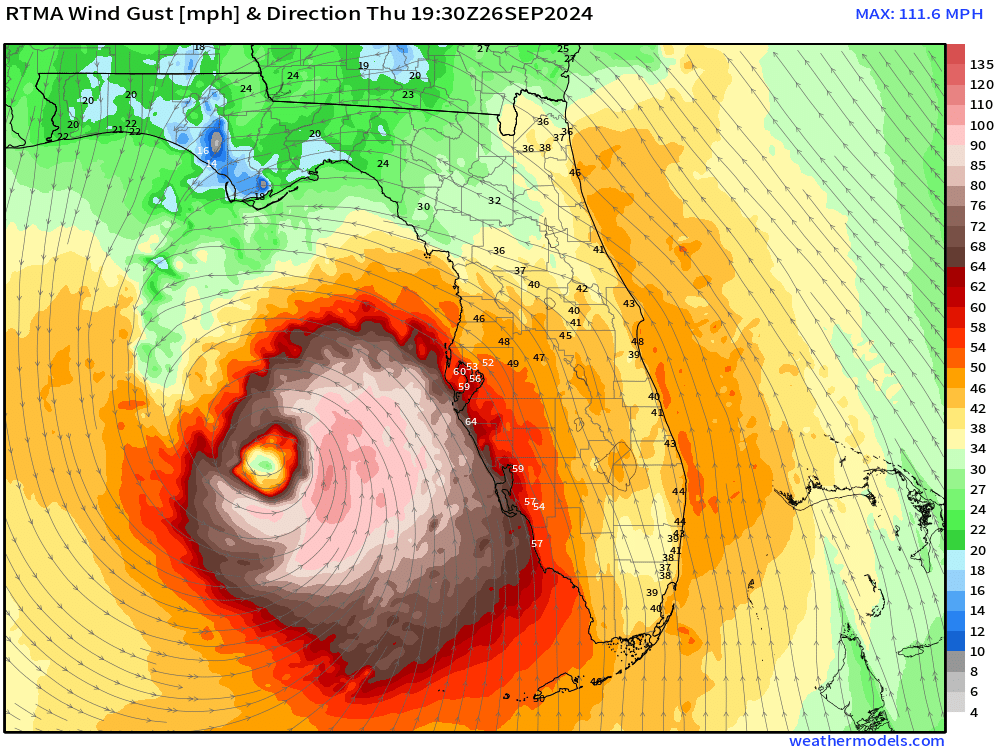
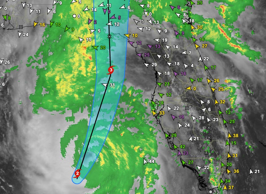
All of the most destructive winds, and likely the gusts well over 100 mph, will be packed into this inner core. If you get the inner core, you experience the worst of a major hurricane, especially on the east side of the eyewall. If you’re close to it but not in it, you likely get lower-end hurricane gusts, which will extend much farther away from the center on the east side of the storm as shown on the wind gust analysis map. If Helene’s core stays fairly compact and an eastward component to its movement continues, Tallahassee would miss the inner core. I’ll be watching over the next few hours for any signs of that changing, but that’s how it stands now.
8:05p: New NHC intermediate advisory
The NHC’s 8 p.m. advisory is out, and there is little change from the previous information we had. Estimated minimum central pressure is down to 942 millibars, and motion remains to the north-northeast (25 degrees) at 23 mph.
Checking on radar, Category 4 Helene’s outer core is now pushing on shore into Florida’s Big Bend. While on-the-ground weather observations are sparse in this part of Florida, Cedar Key recently reported sustained winds of 52 mph and a gust to 65 mph, so tropical storm conditions with embedded hurricane-force gusts are likely to overspread the Apalachee Bay coastline in the next hour.
7:55p: Wind and surge moving in
The worst of Helene’s winds are now advancing north into Apalachee Bay, while the west-central Florida coast sees the worst of what they are going to see. There have been a number of 70-80 mph gusts in the St. Petersburg area in the last couple of hours, and increasingly onshore winds plus incoming tide are pushing water levels to flood stage in the Bay Area as night falls.
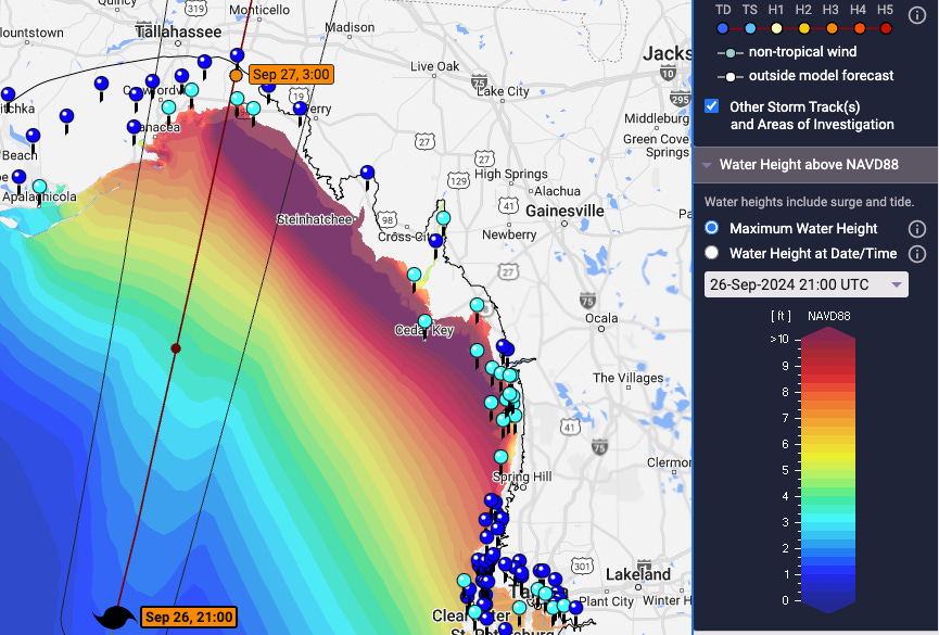
Plotting the updated NHC expectation of a track into central or east-central Apalachee Bay, surge is expected to exceed 10’ tonight from roughly St. Marks east to Crystal River, particularly as landfall is timed closed to high tide in the 11 pm-ish timeframe. These values will likely push into the NHC’s peak 15-20’ range in eastern Apalachee Bay on this track.
7:25p: Why Helene is strengthening
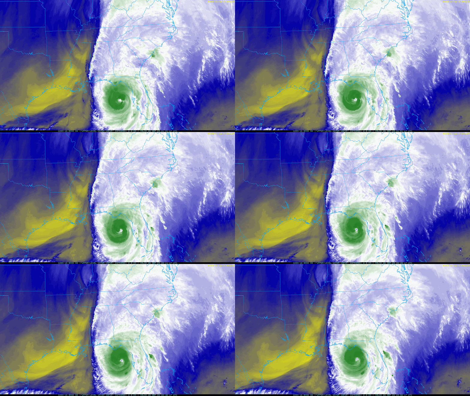
Helene is continuing to strengthen as it tracks north-northeast, shedding several more millibars of central pressure on the second Hurricane Hunter pass. Historically, the northeastern Gulf isn’t a favorable location for hurricanes to rapidly intensify, despite recent history. In this case, Helene’s intensification was made possible by water temperatures several degrees above normal, plus the upper-level low over Arkansas and Tennessee on the water vapor imagery above. This low is doing the work of fanning the “exhaust” from Helene’s powerful convection hundreds of miles to the north.
One other thing to be aware of is that Helene and this upper low will spin around each other post-landfall, causing the track of the hurricane to bend back north at some point tonight or early tomorrow. While it’s absolutely good news (for Tallahassee, not elsewhere in the Big Bend) that Helene is passing Tallahassee’s longitude now, be aware that a turn more northward and less northeastward may develop in the next few hours, putting Tallahassee deeper into the northwestern quarter of Helene’s core.
6:55p: Inner wind core takes shape; Tallahassee risks
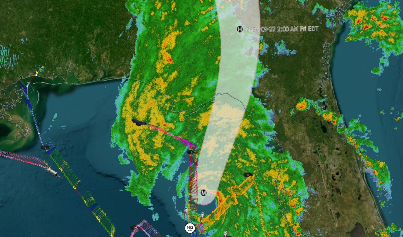
That new center fix from the Hurricane Hunter plane places Helene’s center about 175 miles south-southeast of southwest Tallahassee as of 6 p.m. With Helene now basically even with Alligator Point’s longitude, the most probable landfall location is likely somewhere between just southeast of St. Marks and south of Perry, likely around midnight. With an eye diameter of 30 miles, the very worst of the wind damage is most likely to be along and 10 to 20 miles east of the track. That once again lines up Taylor and Dixie Counties for the worst of a major hurricane landfall.
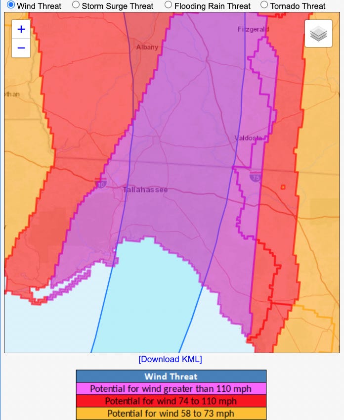
Note well that the winds in the western half of the storm, including on land, will be certainly destructive as well. Should Tallahassee see Helene go just to our east, we may well be better off than our eastern neighbors, but we are still likely to catch the northwestern eyewall of a major hurricane. This will produce a level of damage well beyond what Tallahassee saw in Hermine (peak gust 60-70 mph), Michael (peak gust 70-80 mph), or Kate (peak gust ~80-90 mph). NWS Hurricane Threats and Impacts products continue to highlight the potential for peak wind gusts tonight of at least 110 mph across the eastern Panhandle, Big Bend, and Apalachee Bay coasts, including inland to Tallahassee, plus across south-central Georgia. Be ready to retreat to a sturdy interior room when the eyewall reaches your location in these areas.
6:25p: NHC Update
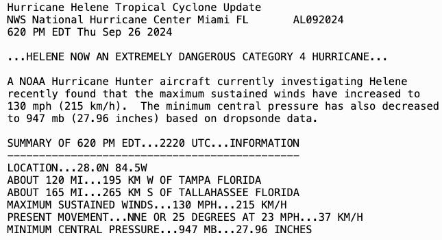
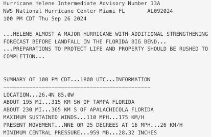
Here’s the text of the NHC statement confirming the upgrade. Sustained winds now estimated at 130 mph in Helene’s eastern eyewall.
6:20p: Hurricane Hunters find a Category 4
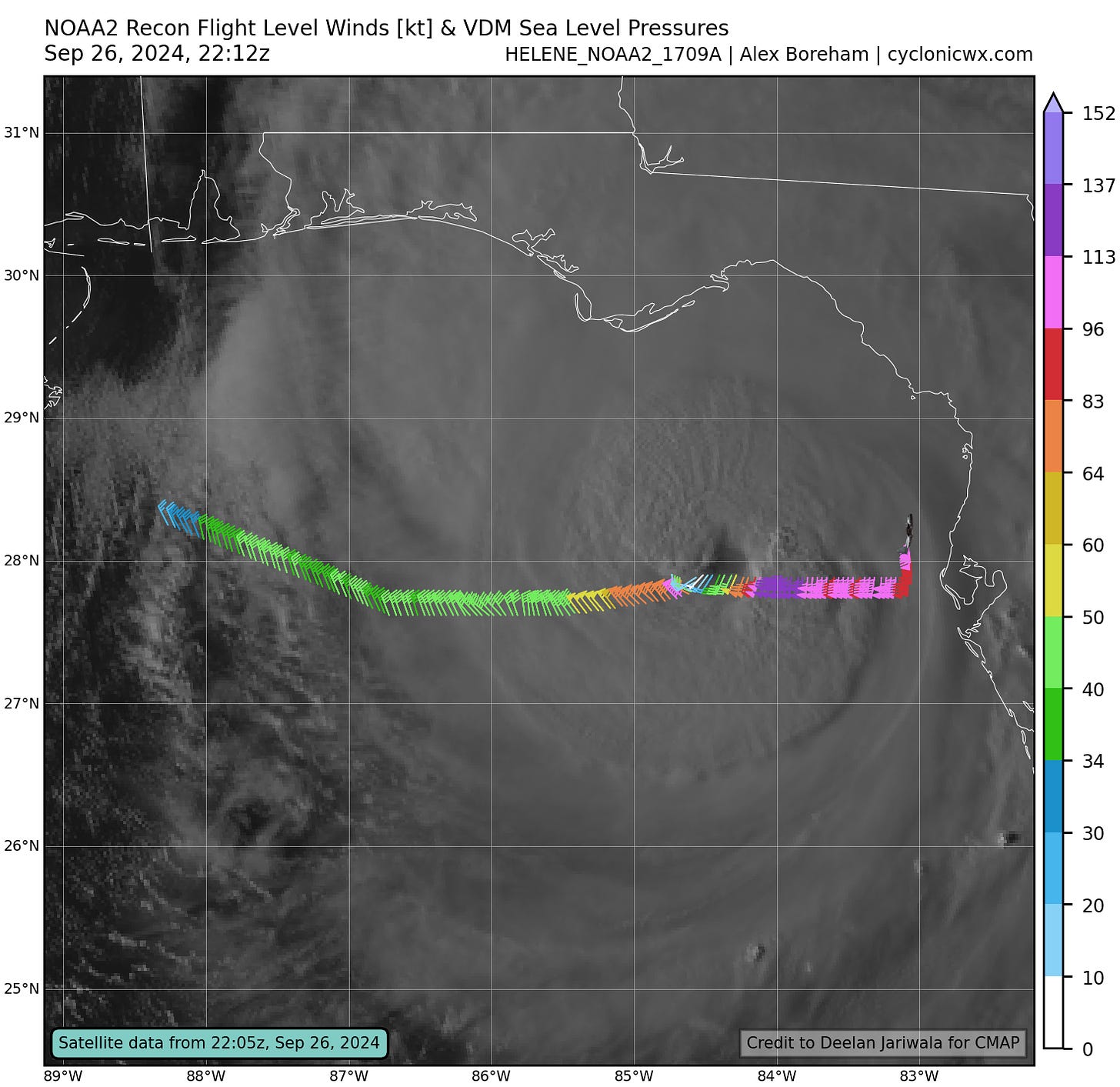
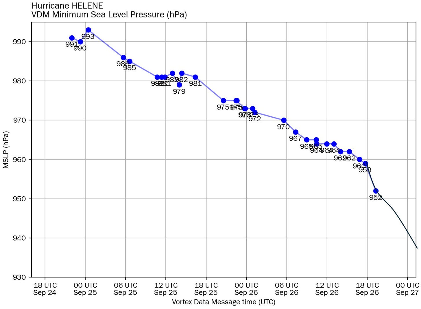
The Hurricane Hunters have completed a bumpy eyewall passage, finding minimum central pressure down another four millibars or so since the previous “center fix” three hours ago. Flight level winds have also increased sharply, to around 100 knots in the western eyewall and 135 knots in the eastern eyewall. (Those winds are well above the surface and have to be reduced to make an estimate of surface winds.) This data shows Helene is forming a tight core of destructive winds within its broader circulation, which will cause devastating damage when it comes ashore later tonight. Based on this data, the NHC has upgraded Helene to a Category 4 hurricane.
Also note that while Helene is increasingly symmetrical, the wind speeds on the eastern and western halves of the storm are different by around 40 mph. This is because the storm itself is moving at 20 mph, adding its forward momentum to winds on the eastern half and subtracting it from the west. Still, both halves of the storm are clearly packing destructive winds at this point.
5:50p: Core structure continues to improve
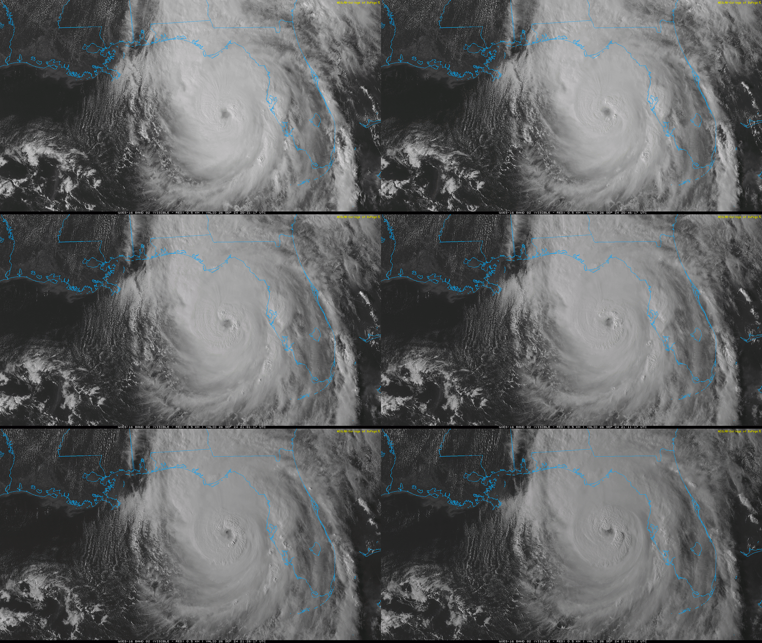
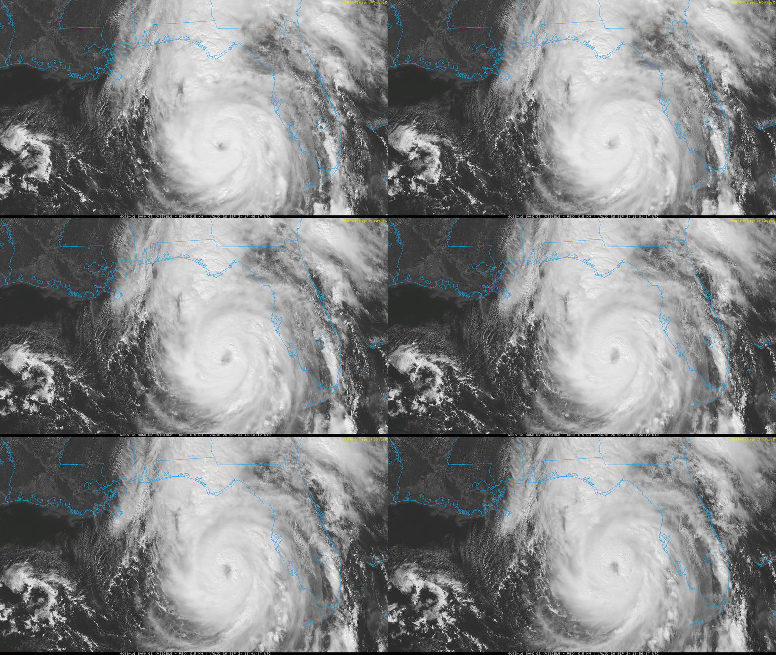
As we await the Hurricane Hunters crossing the center of Helene, visible satellite imagery continues to show a rapidly intensifying hurricane. Twin convective bursts are rotating around the inner eyewall, with a number of lightning strikes noted in the northern eyewall as well. We’ll see what the reconnaissance plane finds, but don’t be surprised if it is a Category 4 hurricane.
5:25p: Final Hurricane Hunter mission enroute
With Helene passing about 125 miles west of Tampa in the 5 o’clock hour, attention is turning north to the Big Bend, where the first push of heavy rainfall associated with the central convection of Helene is now making it onshore in Apalachee Bay. Conditions will deteriorate quickly as this rain moves inland, with tropical-storm-force gusts following soon behind.
In the air, the final NOAA Hurricane Hunter mission that will be keeping tabs on Helene through tonight’s landfall is enroute to the hurricane. That aircraft’s first pass through the center in the next hour will be telling, as the previous plane found a sharp drop in pressure on its last eyewall passage. That data will also give us a fresh read on what Helene’s windfield looks like, and hard data regarding its forward speed and heading. Regardless of nudges one way or another, a track directly into central Apalachee Bay is a virtual certainty at this point, and the destructive winds of Helene’s core will reach the coast in another 2 to 3 hours, then push inland across the eastern Panhandle and Big Bend, including Tallahassee, prior to midnight.
5:00p: New NHC advisory issued
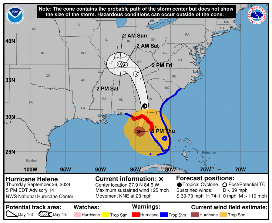
The NHC has issued their 5 pm advisory package, including a new position and intensity estimate, as well as track and intensity forecasts. Maximum sustained winds are now 125 mph, which is on the upper bound of Category 3 intensity. The next forecast point at 2 a.m. still has Helene as a category 2 deep into Southwest Georgia, but the NHC discussion product strongly indicates that NHC forecasters believe Helene will reach Category 4 strength at some point prior to landfall.
Critically for Tallahassee, the eastern Panhandle, and the Big Bend, hurricane-force winds associated with Helene’s core extend almost 60 miles east and 45 miles west of the center of circulation. The track forecast has been shifted east perhaps 10 miles at 5 pm, but given the large size of Helene’s core, is not likely that Tallahassee will miss it. I’ll be talking more about wind expectations soon.
4:30p: Gulf Coast surge
Those coastal wind gusts in the 50s and 60s have already been driving significant storm surge across the Florida Gulf Coast this afternoon, as expected.
Surge was in the 3-5’ range across Southwest Florida, and already pushing 4’ in Cedar Key well ahead of the stronger winds. Afternoon low tide is causing waters to temporarily recede a bit in Apalachee Bay, but the terribly timed high tide around 11 pm is also likely to coincide with the strongest onshore winds of hurricane- and major-hurricane-force.
The 15-20’ surge values in the NHC forecast for Apalachee Bay are looking very realistic given Helene’s size and strengthening, and it is not too late to leave if you are still in an evacuation zone in Apalachee Bay with heavy rainfall still several hours off.
4:05p: Winds across Florida and NHC update
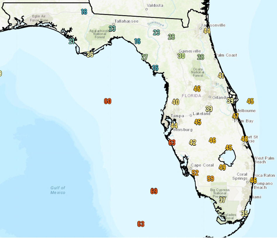
Helene is coming in drier than expected for a lot of Florida so far (other than the flooded Central Panhandle), but the Tropical Storm Warnings are verifying across the state. In the NHC’s 4 pm update, they noted a recent sustained wind of 54 mph at the mouth of Tampa Bay, and a 63 mph gust at Sarasota-Bradenton Airport. (Additionally, minimum central pressure has plummeted another 8 millibars to 951, which is alarming and indicative of rapid intensification.) The 3:30 pm NWS wind gust snapshot above shows Helene’s 300+ mile tropical storm wind radius in full effect.
Peak gusts so far today south of Ocala have generally been in the expected 40-55 mph range, with top gusts in the 50-65 mph range on the Southwest and west-central Florida coasts. There has been no notable wind in North Florida, where it continues to be eerily still.
3:50p: Radar and rainfall accumulations check
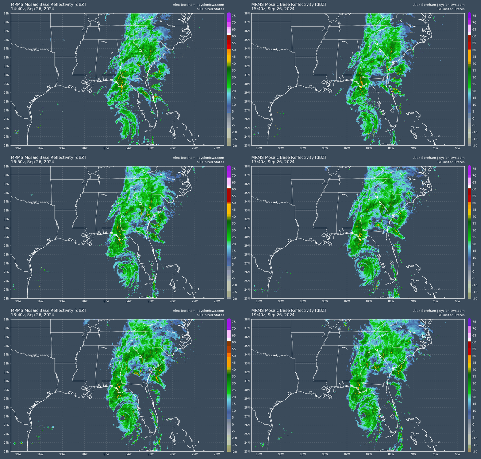
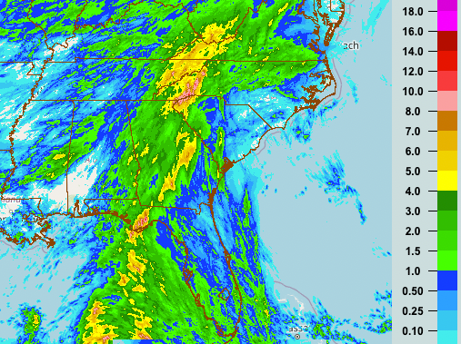
At ground level, Helene is producing heavy rainfall across much of the Southeastern U.S., while large swaths of Florida are actually seeing less rainfall than expected from the storm. The heaviest rainfall in Florida is continuing to concentrate over the Apalachicola River Valley, where Flash Flood Warnings are in effect. Steady and occasionally heavy precip is also falling in north Georgia and the Carolinas.
However, much of Central, South, and Northeastern Florida have seen only a few bands, and rainfall totals mostly less than 1”. This is seemingly because Helene has wrapped up some dry air around its periphery. This dry air is not penetrating the powerful core of Helene, which remains offshore approaching 4 p.m.
3:20p: Another look from space
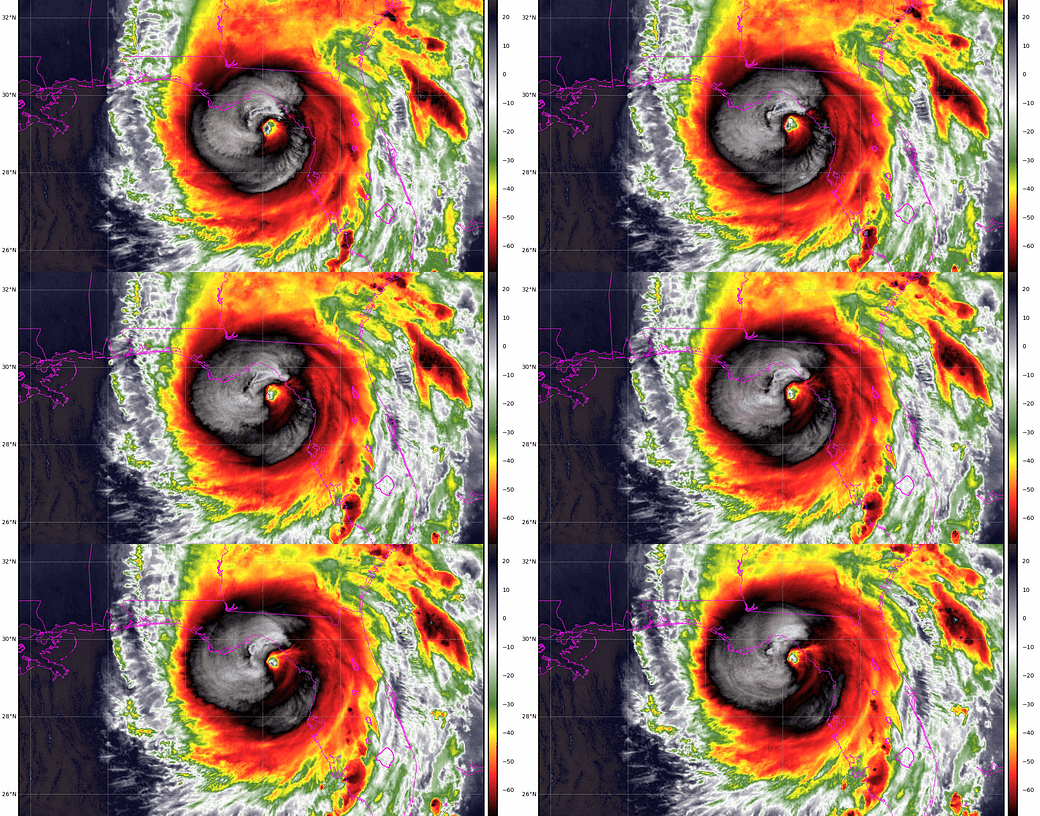
Here’s another look at Helene from satellite, this time using infrared imagery. Colors on the satellite loop denote how cold the storms ringing Helene’s center are. The colder the tops of the clouds, the taller and more intense they are.
The storms around the eyewall this afternoon are very tall, very strong, and once again, increasingly symmetrical. This image also overlays afternoon GFS model tracks, and show the center hurricane is closely following expectations and not deviating much left or right from its forecast course into Apalachee Bay.
3:05p: Helene from above
So far, I’ve talked a fair amount in the liveblog about the widespread threats and hazards associated with Major Hurricane Helene, but less about what the storm is actually doing now. I’ll be focusing on current conditions in the next hour.
First up, this is what Helene looks like, looking down from space right now. I don’t like what I’m seeing here, as Helene’s eye is gradually clearing out and intense convection is forming a more symmetrical ring around that eye. Hurricane Hunters reported a 26-mile wide closed eyewall on their last pass through the center. Collectively, those are all signs of a healthy, intensifying hurricane, one likely to keep strengthening (as forecast) through the afternoon.
2:40p: Breaking: Helene now a Category 3
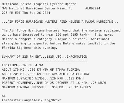
The NHC issued a special, unscheduled, update a few minutes ago to confirm that Helene is now a major (Category 3 or above) hurricane, with sustained winds of around 120 mph as observed by Hurricane Hunter aircraft.
This rapid intensification catches the hurricane back up to the intensity forecasts from yesterday, which showed Helene becoming a Category 3 in the eastern Gulf this afternoon.
2:25p: Threat assessment, part 2
In addition to the wind and surge threats, life-threatening flooding is occurring and forecast in Florida and the Southeastern U.S. The next post will look at where it is coming down this afternoon, but let’s start with the broadest perspective of where watches and warnings, indicative of precipitation threats and impacts, are in effect.
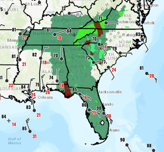
As with the wind advisories in the previous post, it’s a massive swath of the Southeastern United States that is under a Flood Watch this afternoon— the areas in dark green from Florida (other than Pensacola, who I’m starting to resent, sorry Pensacola) extending north to Virginia, and west to Arkansas and southeastern Missouri. Embedded within the watches are significant Flood and Flash Flood Warning areas in bright green and dark red, respectively. A large Flash Flood Warning is currently in effect in Florida’s Apalachicola River Valley, where excessive, heavy rain has been falling since last night.
Given the heavy rains to come and saturated soils in many of these areas, NOAA has highlighted a region from the central Panhandle into western North Carolina as being at the highest risk of flash flooding, including the Tallahassee region where landfall is expected this evening. “High risk” events are pretty rare and account for much of recorded flood damage, so take the flood threat seriously by not driving into floodwaters of any depth and evacuating if notified by local emergency officials.
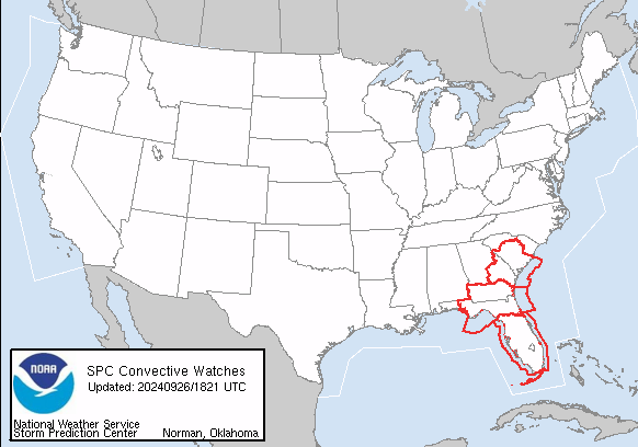
Finally, much of Florida, eastern Georgia, and South Carolina are currently under a Tornado Watch, as Helene’s bands are capable of rapidly spinning up damaging tornadoes many hundreds of miles away from the center. And indeed, I’ve seen several Tornado Warnings cross my desk this afternoon for locations across the eastern Panhandle. Keep a means of receiving Tornado Warnings on hand if under a watch and be ready to seek shelter.
1:55p: New NHC intermediate advisory
The NHC has issued the 2 p.m. intermediate advisory a few minutes early, which is normal. (We call this an “intermediate” advisory because unlike the full advisory packages typically issued at 5 and 11 a.m. and 5 and 11 p.m., there is not an updated track and intensity forecast with these NHC products. They are issued each at the 3-hour halfway point between the 5s and 11s (the 2s and 8s) to update intensity, positions, and warnings.
Takeaway here from the 2 p.m. advisory is that Helene’s estimated sustained winds are up another 5 mph to about 110 mph, or just shy of Category 3 status on the Saffir-Simpson Hurricane Wind Scale, which as I’ve been highlighting this week, isn’t really the right scale to evaluate Helene because of its massive size. Pressure as measured by NOAA Hurricane Hunters continues to steadily fall, and is now below 960 millibars. Bottom line is Helene is strengthening as expected. You can read the advisory here.
1:45p: Threat assessment, part 1
Helene is a four-quadrant tropical threat, producing widespread and significant surge, wind, rain, and tornado impacts. I’ll be dealing with each of those threats individually in the next few hours, but let’s get things starting by reviewing the National Weather Service watches and warnings that are in effect for each impact, starting with the wind and surge.
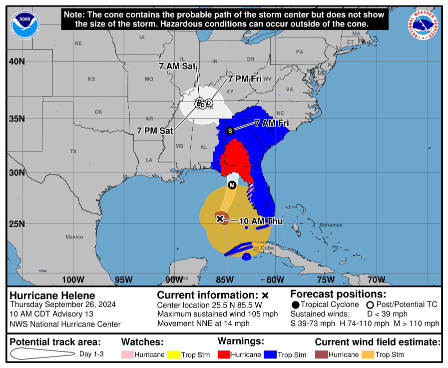
For winds, the NHC’s new “experimental” cone is a neat visual summary of the incredible extent of Helene’s windfield, and the threat that the hurricane poses to a massive swath of the Southeastern U.S. A Hurricane Warning is in effect for the Central and Eastern Florida Panhandle, Big Bend, and northern Nature Coast, as well as the southwestern quarter of Georgia and a piece of southeastern Alabama. A Tropical Storm Warning is in effect for the rest of Florida other than the lucky ducks in Destin and Pensacola, the rest of Georgia, all of South Carolina, some of western North Carolina, and a bit more of eastern Alabama. This is due to Helene’s strength, size, and likely 25+ mph forward speed at landfall. Not sure I’ve ever seen a broader area under tropical wind warnings at once.
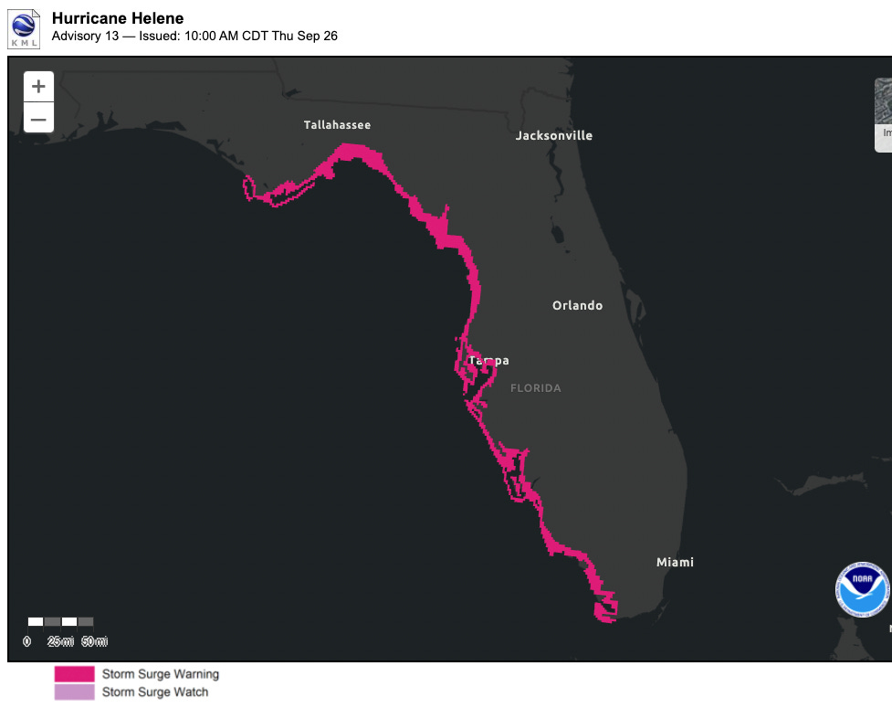
All that wind is pushing a wall of water through the eastern Gulf into Apalachee Bay, and Storm Surge Warnings are in effect from Cape San Blas into Everglades National Park. If you’ve received a warning and evacuation order, hopefully you’ve already compiled. If not, you still have time to safely do so for a few more hours. That water wall is coming, and you need to be inland enough to not be in it tonight. Significant surge is already occurring in west-central and southwest Florida, as I’ll show in a future post.
1:15p: Welcome, buckle up
Welcome to WeatherTiger’s Hurricane Helene landfall live blog. If you’ve never read WeatherTiger’s Hurricane Watch prior to today, I’m Ryan Truchelut, Chief Meteorologist at WeatherTiger, a Tallahassee-based weather consulting and forecasting company, and I’ve been preparing for days like this my entire life. I’ve been in the hotseat for all of Florida’s worst hurricanes of the last decade: Irma, Michael, Dorian, Ian, Idalia. I’ve been researching hurricanes for over 15 years and graduated from FSU’s doctoral meteorology program. I’ve been through the eye of Hurricane Charley. However, I’ve never been through the eyewall of a Category 3+ hurricane in Tallahassee, because the last time that happened was (probably) 1842.
Over the next 10 hours or so, I’ll be frequently updating this page with minute-by-minute meteorological developments: the latest NHC advisories, National Weather Service warnings, local observations from across Florida, and forecasting insights on all aspects of this catastrophic storm. My goal is to keep you safe by providing accurate, no-hype, real-time information until Helene has moved out of Florida, or, realistically, until the bits, bytes, and electrons stop flowing here at WeatherTiger World HQ in Southeast Tallahassee. My house is 20 miles from the Gulf on high ground, so while I’m confident in my physical safety, I’m not confident that my communication contingencies stay up through the night. It all depends on where Helene’s core goes and how strong it is. I will post until I can post no more, which is all any of us can do, really.
If you’re just getting caught up on Hurricane Helene, it’s been busy this morning. Per the NHC's 11 a.m. advisory, Helene has strengthened to a Category 2 hurricane, with maximum sustained winds estimated at 105 mph, and it continues to intensify this afternoon as it accelerates north-northeast towards Apalachee Bay. The eyewall is likely to reach the the Big Bend coastline around 8 p.m., with Helene’s center probably crossing the central Apalachee Bay shore prior to midnight.
Helene is a gargantuan hurricane, with tropical-storm-force winds extending almost 350 miles southeast of the center. These winds are overspreading much of South and Central Florida currently, and Tropical Storm and coastal Storm Surge Warnings are in effect. For North Florida and west-central Florida where Storm Surge and Hurricane Warnings are in effect, weather goes downhill this afternoon, and the truly life-threatening conditions arrive in the evening hours. You should be sheltering in place by late afternoon on the Nature Coast, in the Big Bend, and the eastern Panhandle.
Folks, we’re in a historically tight spot, facing down the most formidable hurricane threat to the Big Bend in some 180-odd years, a storm that dwarfs last year’s Idalia in scope and impacts. I’m feeling the same anxiety, trepidation, and dread that many of you are. My job is to try to make this awful experience a little less miserable and traumatic by telling you the straight, unfiltered deal on what’s going to happen and when with Helene.
Let's get through this together. Back in about 20 minutes to start rattling through current conditions and the threats ahead.




![[Image of cumulative wind history] [Image of cumulative wind history]](https://substackcdn.com/image/fetch/w_1456,c_limit,f_auto,q_auto:good,fl_progressive:steep/https%3A%2F%2Fsubstack-post-media.s3.amazonaws.com%2Fpublic%2Fimages%2Ffc2ef12f-bd05-4d27-ae47-dc88645d3915_897x736.png)

![[Image of WPC Flash Flooding/Excessive Rainfall Outlook] [Image of WPC Flash Flooding/Excessive Rainfall Outlook]](https://substackcdn.com/image/fetch/w_1456,c_limit,f_auto,q_auto:good,fl_lossy/https%3A%2F%2Fsubstack-post-media.s3.amazonaws.com%2Fpublic%2Fimages%2Fa7d110e7-6384-402d-bc1a-d69e3abfc621_1090x692.gif)

Keep writing, you may be recording a significant event in atmospheric science. My guess is yuu will win the Pulitzer Prize by the time you sign off.
Job well done as usual!Thank you so much for your excellent understandable forecasting and explanations. I would never want to experience the threat of a hurricane with your insights. Hope your wife is doing well.