WeatherTiger's Hurricane Milton Landfall Live Blog [Last Post: 12:50 a.m.]
Tracking Milton moment-by-moment through landfall in west-central Florida.
Our Hurricane Milton landfall liveblog has concluded. We hope you found our coverage valuable as you dealt with this historic storm.
A final Thursday morning briefing on Milton for supporters is here, and our regular daily coverage of the Tropics for paid subscribers will resume on Friday, October 11. If you enjoyed this liveblog, sign up to receive our newsletter at the link below.
Thanks for reading and hope you stayed safe.
12:50a: Wrapping up live coverage
With Milton tracking predictably along the NHC track and having just laid out forecast expectations for east-central and northeast Florida, I’m going to wrap up WeatherTiger’s live coverage for the night with a final check in on the three ongoing hazards from Milton to Central Florida: surge, rain, and wind.
Surge remains an ongoing life-threatening hazard across southwest and west-central Florida and will continue to be so through the night. We don’t have live tidal gauges between Fort Myers and Tampa Bay, but onshore tropical-storm-force winds out of the west are still driving coastal flooding higher in the region, and may do so for several more hours depending on your location. The surge threat will mount through morning along the Northeast Florida coast, where Daytona Beach is seeing 75-80 mph onshore wind gusts currently.
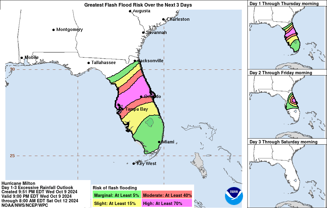
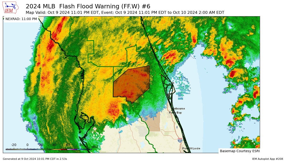
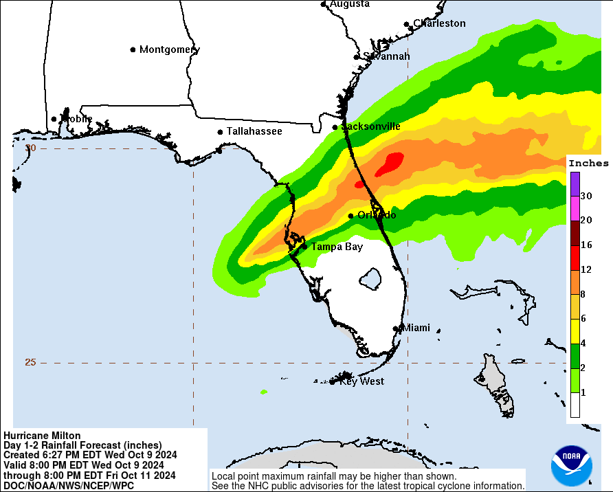
The flooding rainfall threat is the most serious inland hazard. Flash Flood Warnings are currently in effect for the entire I-4 corridor and north to Ocala and Palm Coast across central Florida, as well as for the entire Tampa Bay area. Storm totals along and just north of I-4 are heading for the 10-15” range, and this area is at high risk of overnight flash and urban flooding, which will continue into tomorrow morning and slowly end from west to east.
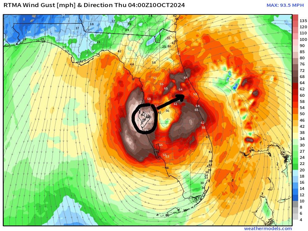
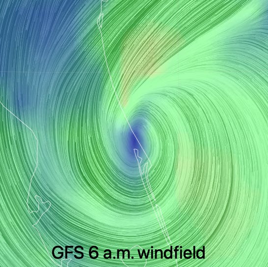
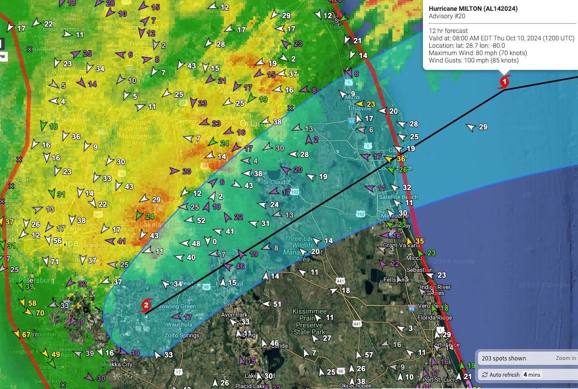
The wind threat is slowly winding down in the Tampa Bay area, but increasing in the Orlando area. Both Orlando and Daytona Beach airports just reported wind gusts of around 85 mph in the past hour, and peak inland wind gusts of 70-85 mph are most likely in the I-4 corridor through about 5 a.m. when Milton will exit the coast near Cape Canaveral. Damaging hurricane-force wind gusts are also expected along the northeast Florida coastline through the morning hours.
This storm still has a long way to go, so keep sheltering in place across Central Florida. I’ll be back in the morning with an update. Until then, good night.
12:10p: NHC update; strange coincidence
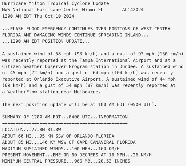
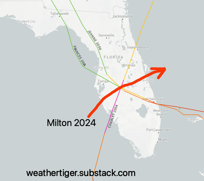
The 12 a.m. NHC advisory still has Milton as a Category 2 hurricane, still hustling east-northeast at 16 mph. Milton is now located in Polk County very near Lake Wales.
If that sounds familiar in hurricane Florida lore, it’s because Lake Wales was the infamous triple point where the paths of Charley, Frances, and Jeanne crossed 20 years ago in the brutal 2004 hurricane season.
On another note, wrapping up the liveblog shortly.
11:55p: Northeast Florida overnight threats
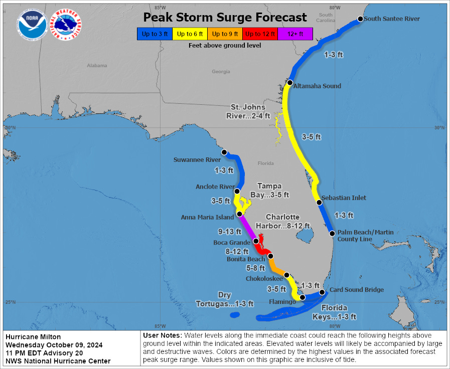
Even as onshore flow continues to cause rising storm surge in southwest Florida (more on this in next post), we do also need to think about the Atlantic coast as well, where surge and wind will combine to cause a damaging and impactful hurricane event. With the new NHC track bringing Milton out of Florida through Cape Canaveral, significant surge is a major concern for Volusia County north to Jacksonville and coastal Georgia where the strongest winds tomorrow morning will be out of the north or northeast. The NHC forecast as of 11 p.m. is unchanged, calling for 3-5’ of surge in this area. If history is any indication, this is also going to cause major beach erosion issues in Daytona Beach, Flagler Beach, and St. Augustine (etc), as onshore flow continues through the day on Thursday.
With Daytona Beach already recording a 76 mph wind gust out of the northeast in the last hour, wind gusts in the upper 70s and 80s are also a good bet overnight and through the mid-morning Thursday in Volusia north to St. Johns Counties. This might be a little lower in coastal Duval County, but gusts in the 60-75 mph range are likely there. Finally, Volusia County is also in line for storm totals of 10”+ of rainfall, and flooding is a major risk both along the coast and inland.
11:30p: Orlando area overnight threats
With the heaviest of the rainfall and strongest winds finally leaving the Tampa Bay area, east-central Florida is now in line for its worst weather, which is starting now and will continue through about 5 a.m. Extreme rainfall and flash flooding is the primary threat and concern, and a Flash Flood Warning is already in effect for much of Metro Orlando. Stay off the roads, as existing flooding will continue to worsen past midnight as rain rates of 1-3”+/hr overwhelm drainage systems and inundate low-lying areas. We are also heading for another long-term flood of the St. Johns River basin, as happened following Ian, with the Orlando Metro and east-central Florida, especially areas along and north of I-4, likely to see 10”+ storm totals from Milton.
The overnight wind risk is notable as well in east-central Florida. Wind gusts so far in the Orlando Metro area are mostly in the 60-65 mph range at the airports. The highest inland winds are still in the northwestern eyewall over west-central Florida, which will angle northeast overnight. With peak wind gusts in Polk County already in the 75-95 mph range and a recent 75 mph wind gust in Leesburg, expect wind gusts out of the northeast to peak out in the 65-85 mph range across east-central Florida, possibly backloaded in the 2 a.m. to 5 a.m. range. Rains should diminish and winds drop off towards daybreak as Milton races away from Cape Canaveral.
11:05p: New NHC advisory
The new NHC advisory package at 11 pm finds Milton centered about 75 miles southwest of Orlando, continuing on an east-northeast heading of 60 degrees at 16 mph. Milton remains a Category 2 hurricane with 105 mph sustained winds, and the next forecast point for 8 a.m. tomorrow already has Milton well east of Cape Canaveral as a Category 1 hurricane; at this rate, Milton will likely exit the Florida peninsula via Brevard County by 5 a.m. or so.
Next couple of posts will focus on overnight and morning wind/rain impacts in the Orlando area and northeast Florida coastline, respectively.
10:45p: Destructive winds in Bay Area
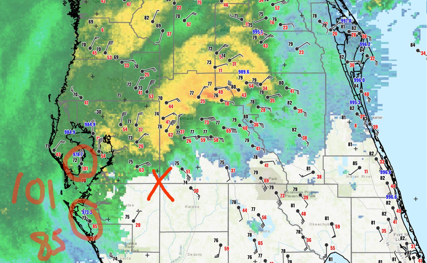
As the center of Milton works into Polk County, the western eyewall is continuing to produce destructive winds in the Tampa Bay region within the life-threatening flash flood event. St. Petersburg airport just saw a gust to 101 mph out of the north, which is truly impressive as that is not a direction with marine exposure. Westerly winds and rising tide will continue to bring storm surge into Southwest and west-central Florida through the night.
Back with the 11 p.m. NHC advisory soon.
10:25p: Extreme rainfall threat continues
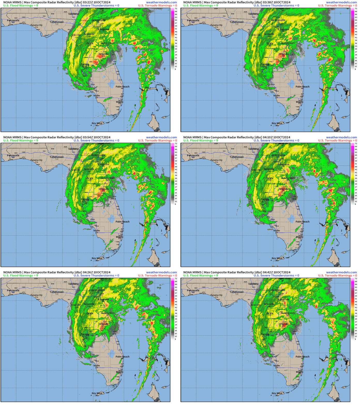
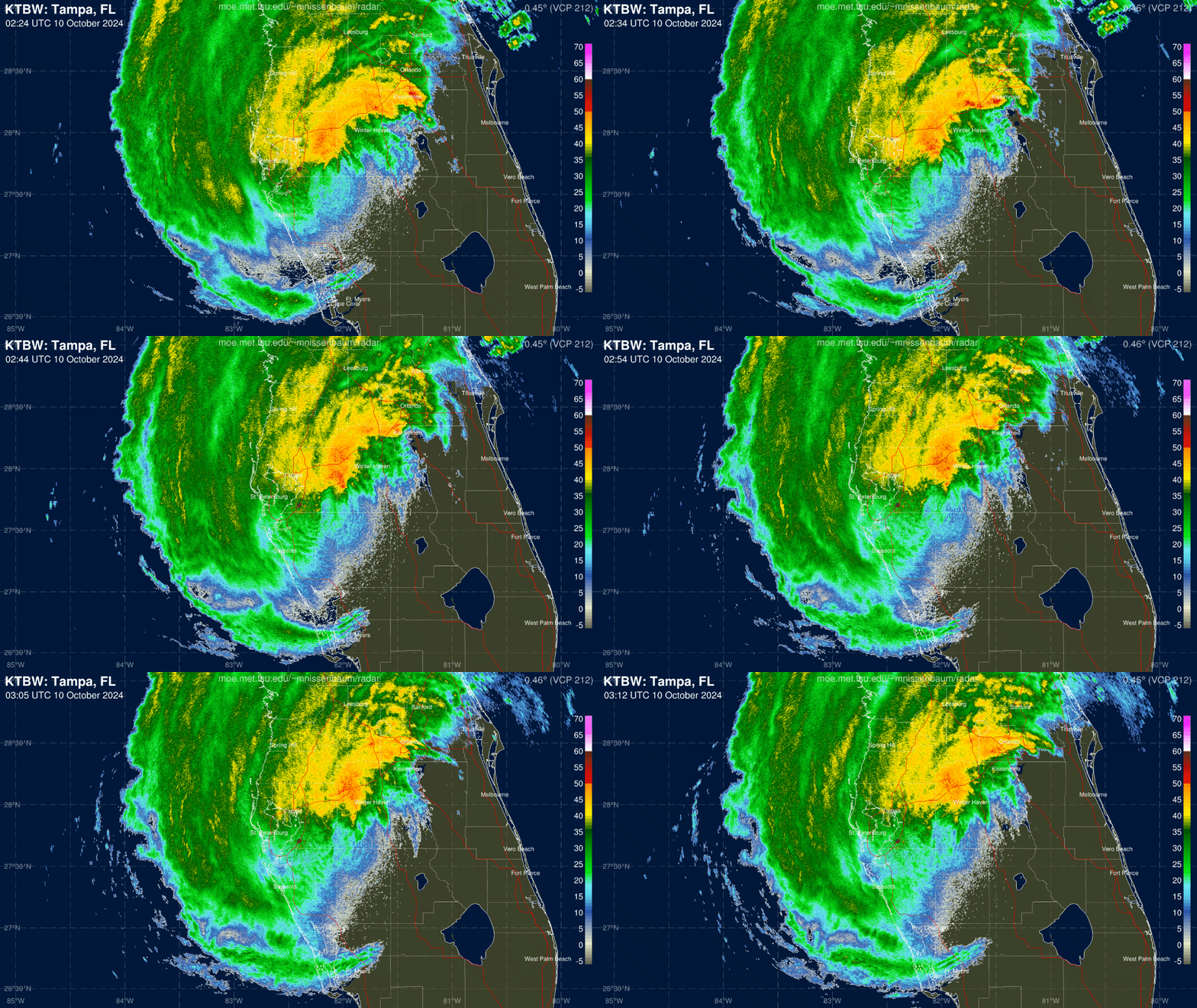
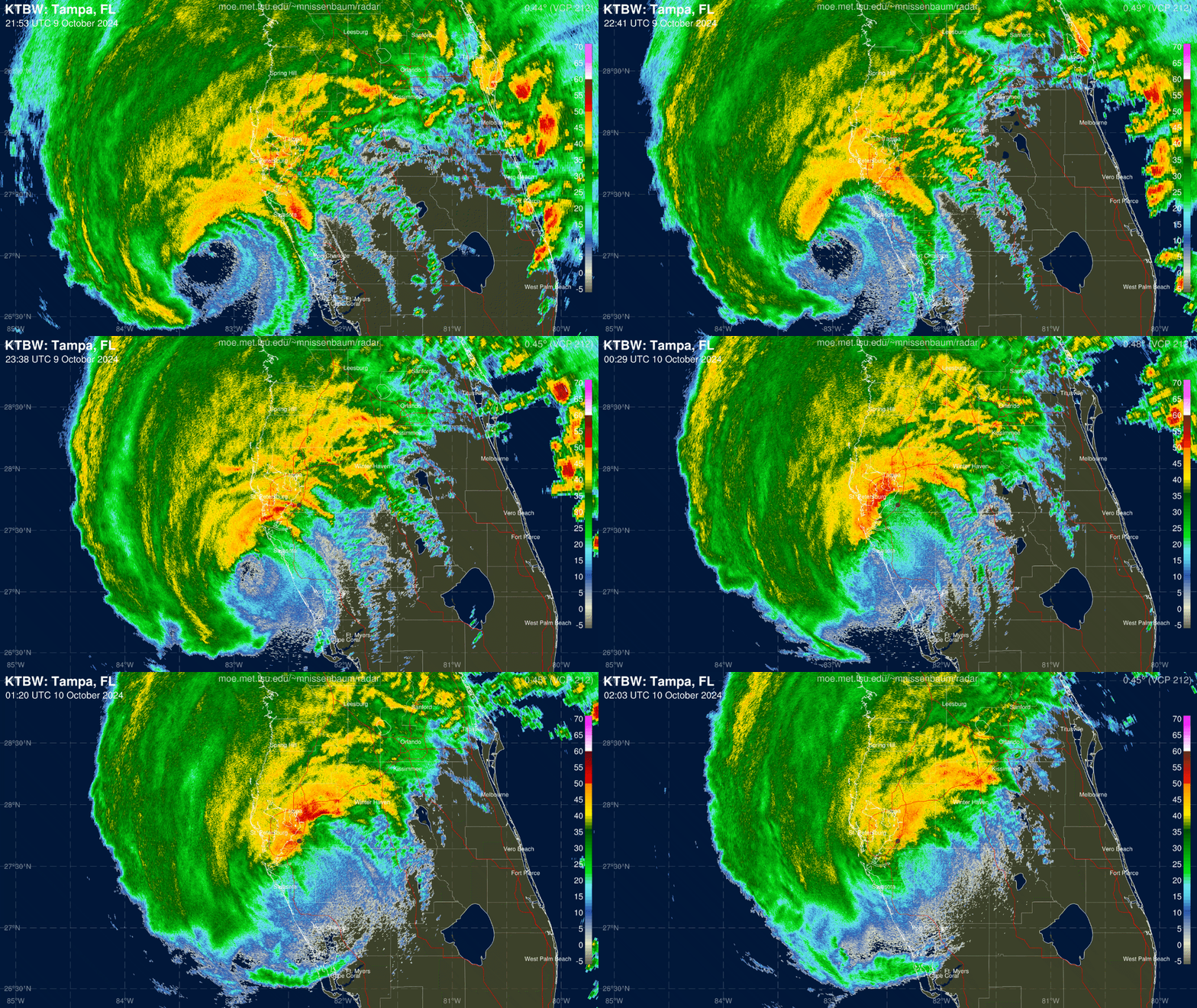
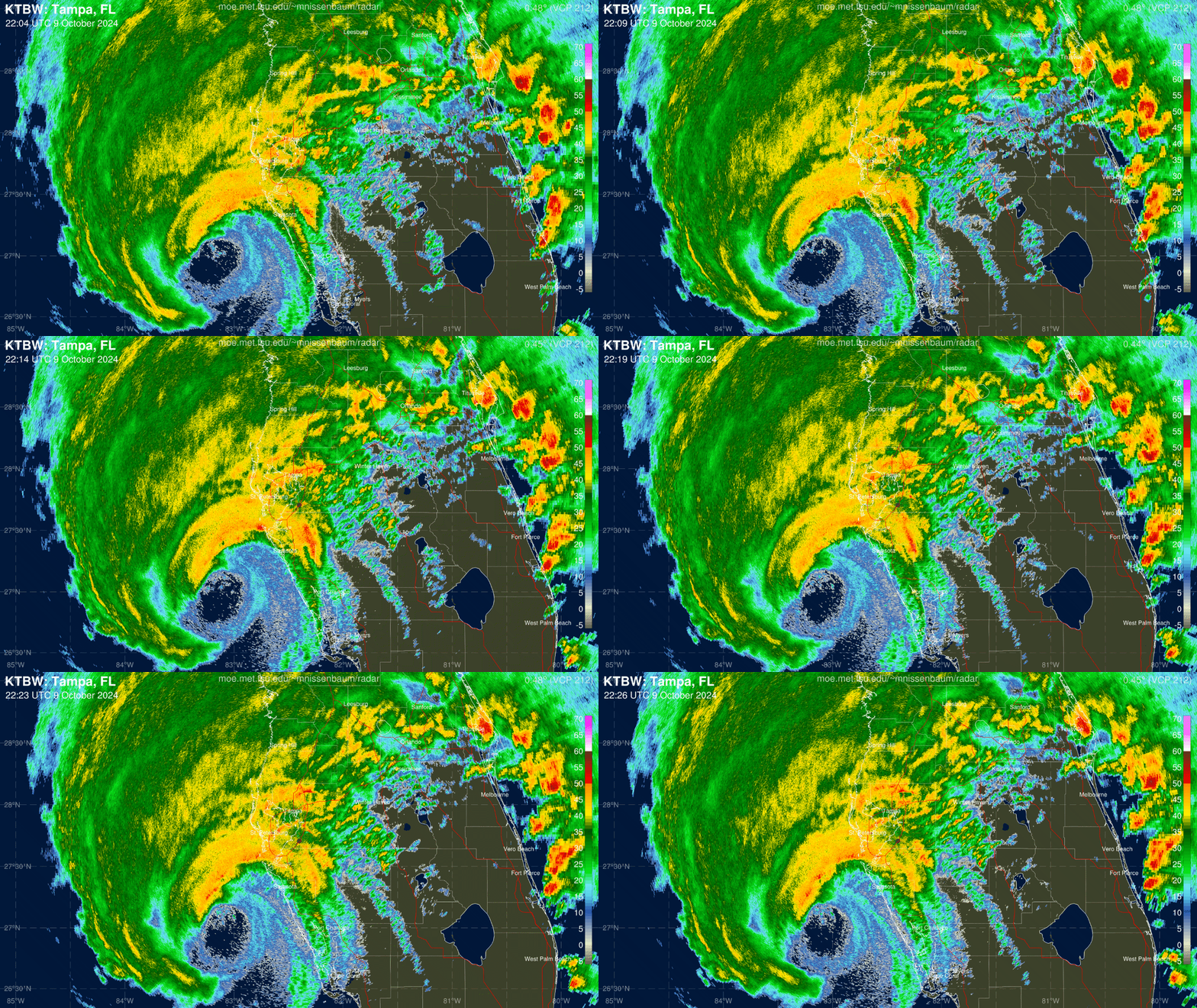
As shown on this long radar loop of Milton, a persistent band of heavy rainfall has set up (as anticipated) along the I-4 corridor, where Milton and a front are colliding. Rain rates of 1”/hr up to an incredible 5”/hour have characterized this band, which will shift northeast and continue to crank through the night across Central Florida.
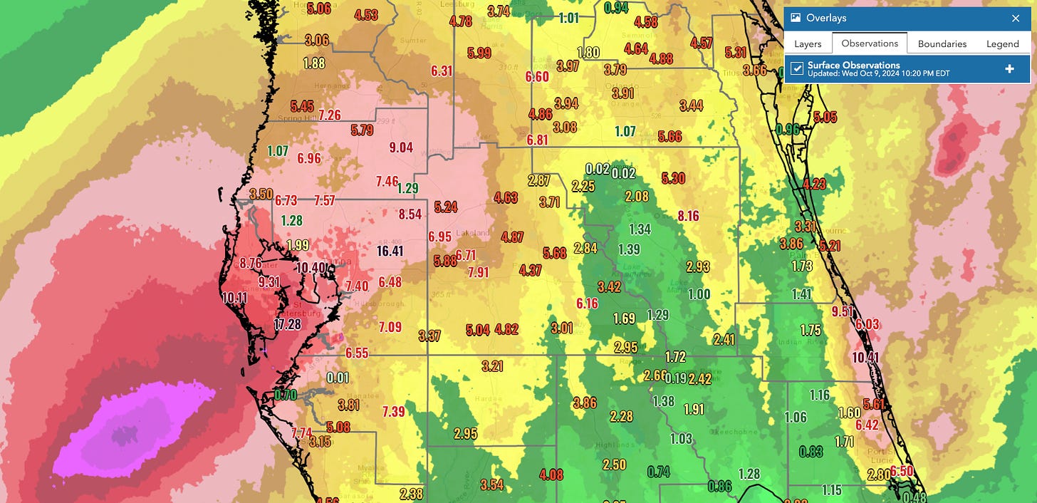
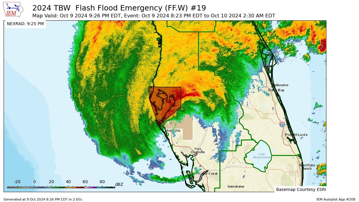
Three-day totals in Pinellas and Hillsborough range from 7-17” so far, and it’s still raining hard there and will be into the early morning hours. Take the Flash Flood Emergency for the emergency it is in the Bay Area, stay indoors, and avoid any and all bodies of water. Farther northeast, the Orlando area has seen general 3-6” totals since Sunday, and your heaviest rainfall is likely to start after midnight and continue through tomorrow morning. Shelter in place and stay off the roads until Milton is over in Central Florida.
10:05p: NHC update
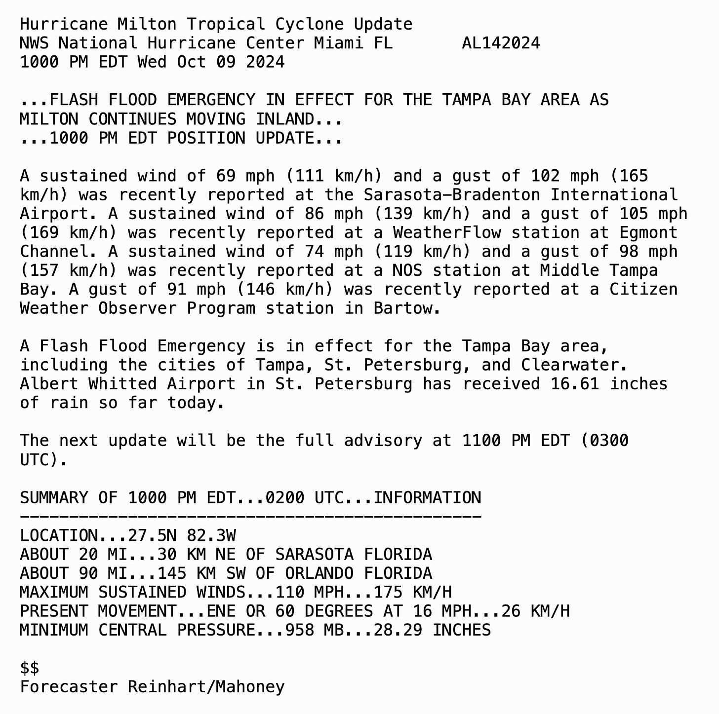
As of the NHC 10 p.m. position update, Milton is now centered about 20 miles northeast of Sarasota, and is now a Category 2 hurricane. Numerous reports of winds over 100 mph, including a gust to 105 mph with 86 mph sustained winds in the mouth of Tampa Bay.
The headline, however, is the continuing Flash Flood Emergency in the Tampa Bay area, with over 16” of rain falling today at the St. Petersburg airport. This is a life-threatening situation tonight across the I-4 corridor, and I’ll look more closely at where those rainfall extremes have fallen and can be expected in the next post.
9:55p: Western eyewall winds
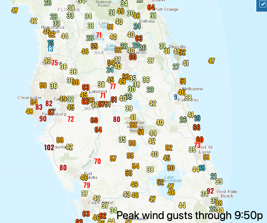
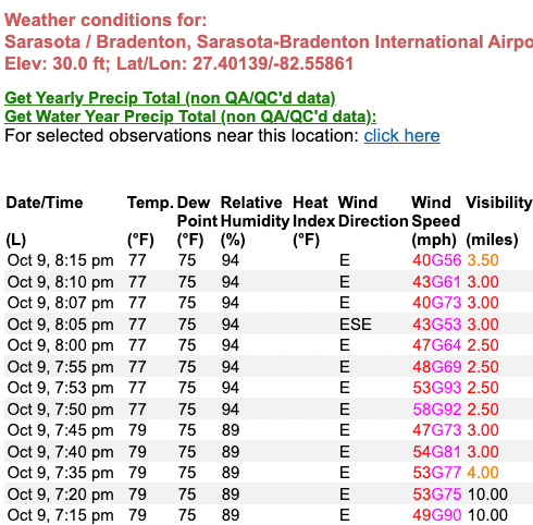
As the western eyewall moves inland across west-central Florida, Bradenton, Sarasota, and Venice are now as predicted seeing extreme winds from the western eyewall of Milton. Sarasota just reported a sustained wind of 69 mph with a gust to 102 mph at 9:36p out of the northwest, and at least one station in the Tampa Bay area had also reported 100 mph or higher wind gusts earlier this evening.
Peak wind gusts at or above hurricane-force are also pushing towards Lakeland, and many stations have gone down in west-central and southwest Florida due to power outages or possibly instrument damage. Sarasota’s airport is no longer reporting a wind observation following the peak gusts in the western eyewall.
9:40p: Flash Flood Emergency in Bay Area
The National Weather Service office in Tampa Bay has issued a Flash Flood Emergency for central Hillsborough, southeastern Pinellas, and eastern Manatee Counties. A Flash Flood Emergency is a rare warning statement, issued only when severe, life-threatening flash flooding is ongoing. In this case, extreme rain rates of up to 5” per hour have been observed. Stay indoors and away from any body of water through the night in the Bay Area!
9:30p: Surge check
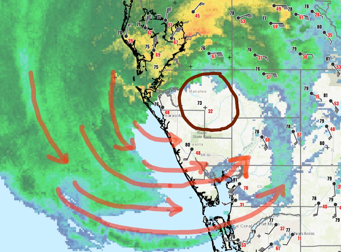
With the center of Milton trackable by surface weather observations, the eye moving into eastern Manatee County means that winds have flipped to out of the north in Sarasota and are more out of the west and northwest south to Venice and Charlotte Harbor. That means onshore winds will be piling the storm surge into west-central Florida for the next several hours on the west and south side of the hurricane. The surge danger is NOT over from Sarasota south, and in many places is just beginning.
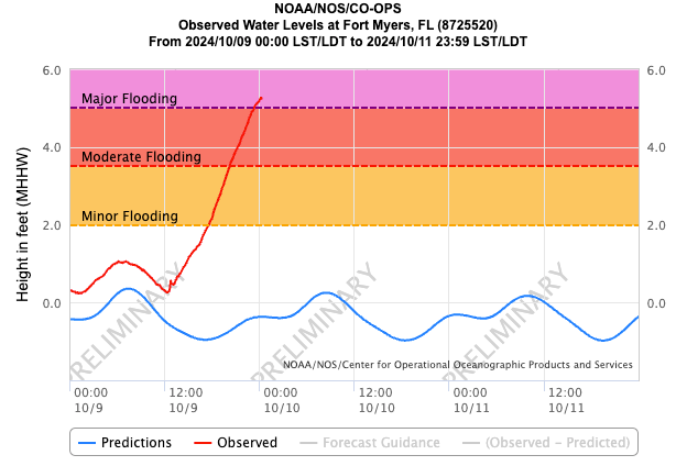
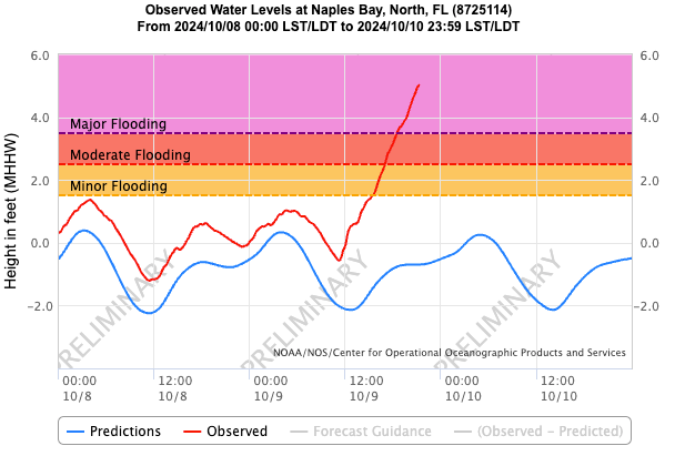
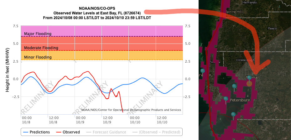
Farther south in Ft. Myers and Naples, surge has generally been on the order of 4-6’ and is still rising. Meanwhile, strong anti-surge of several feet in Tampa Bay as water is blown out of the bay by northeast winds.
9:15p: Landfall portraits
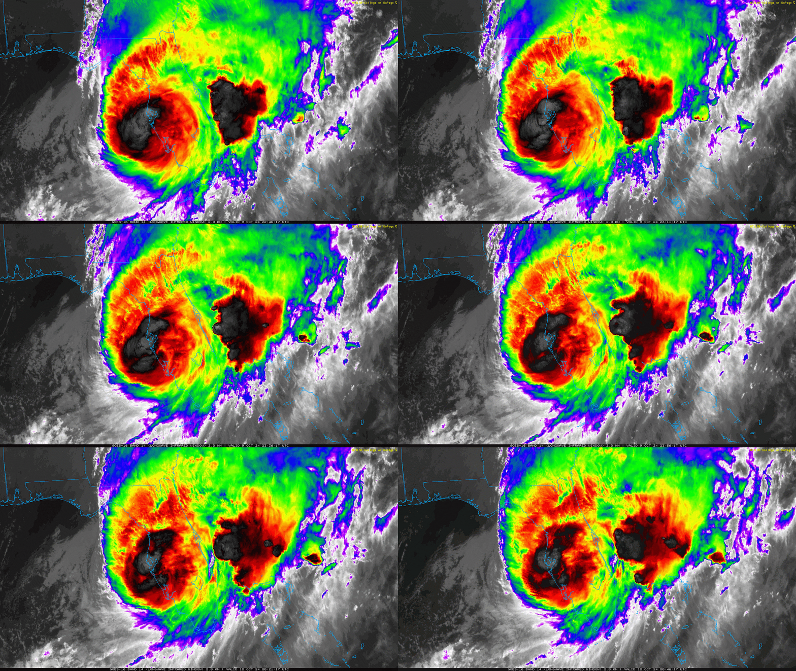
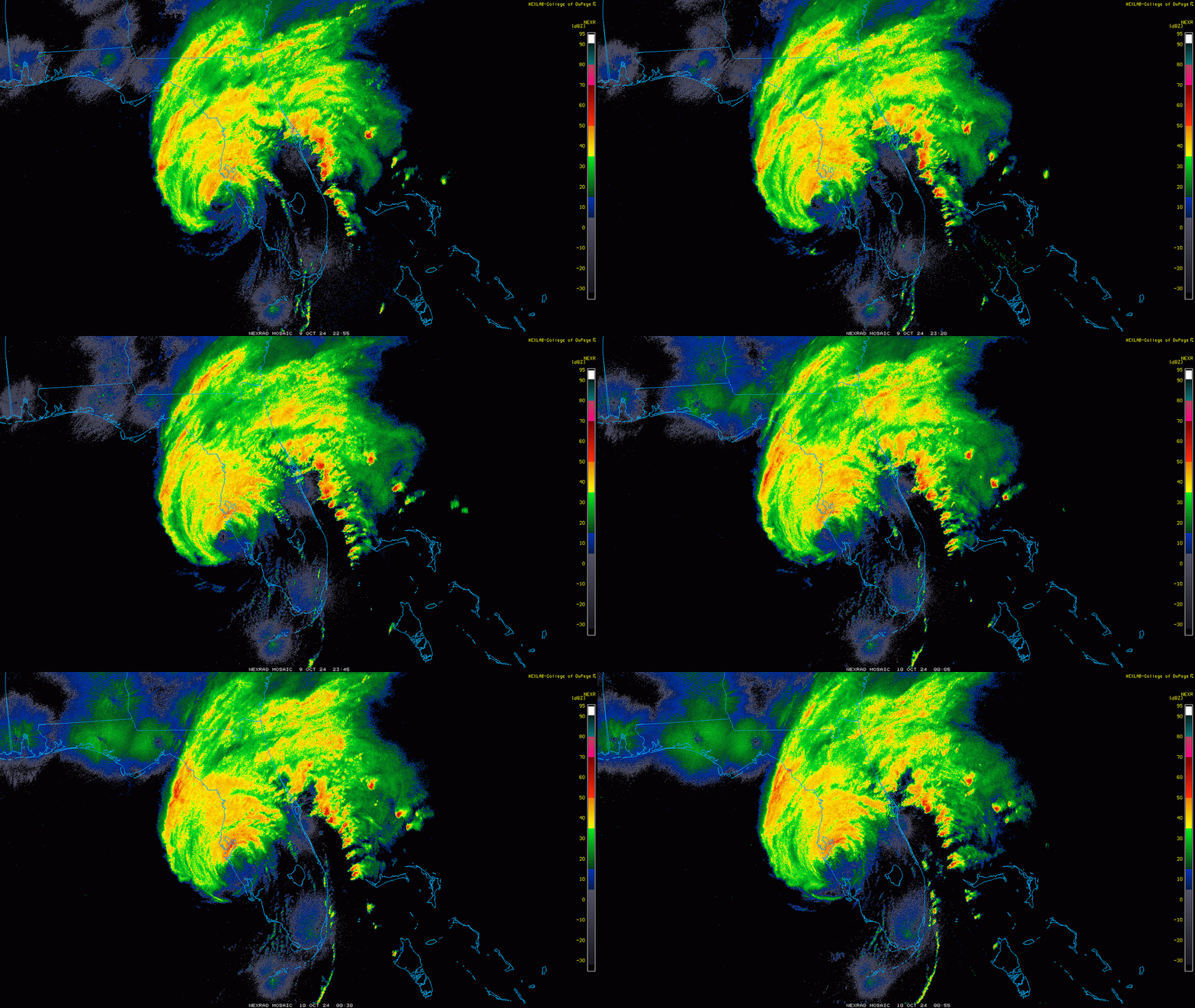
Here’s some various perspectives on Hurricane Milton as it made landfall near Sarasota in the last hour. First, infrared satellite imagery, looking down from space at how cold the tops of Milton’s intense thunderstorms are:
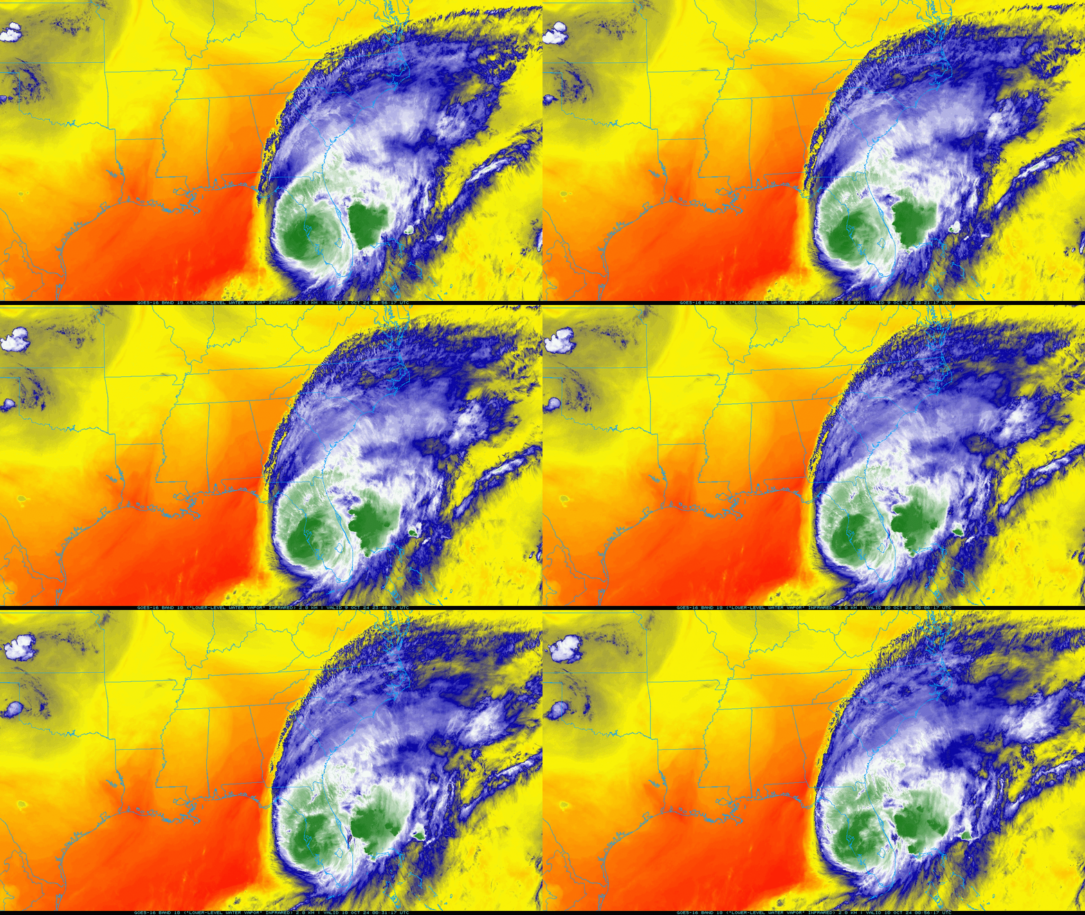
Next, a broader water vapor satellite loop, showing Milton’s outflow as the hurricane interacts with a dip in the jet stream over the East Coast:
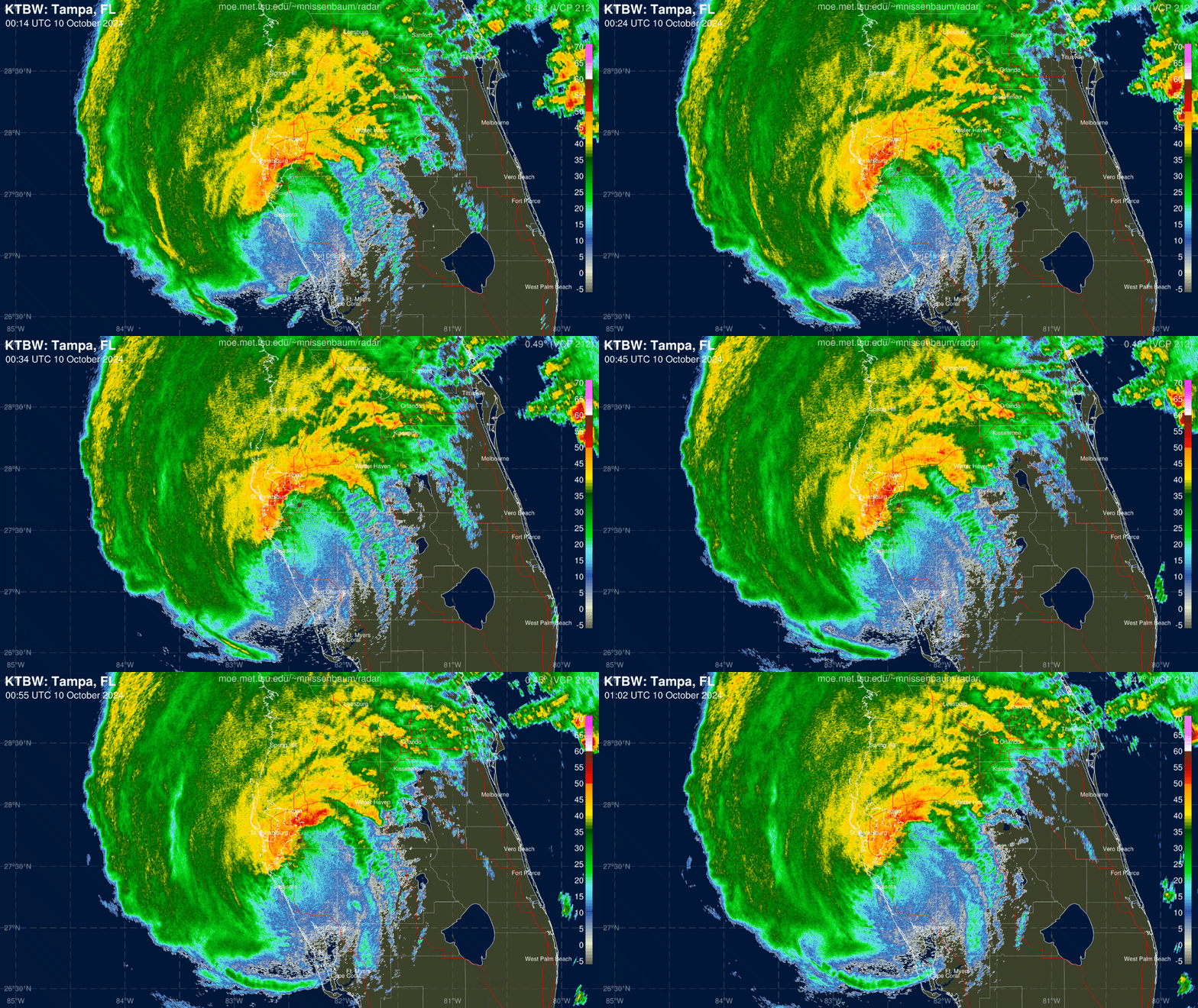
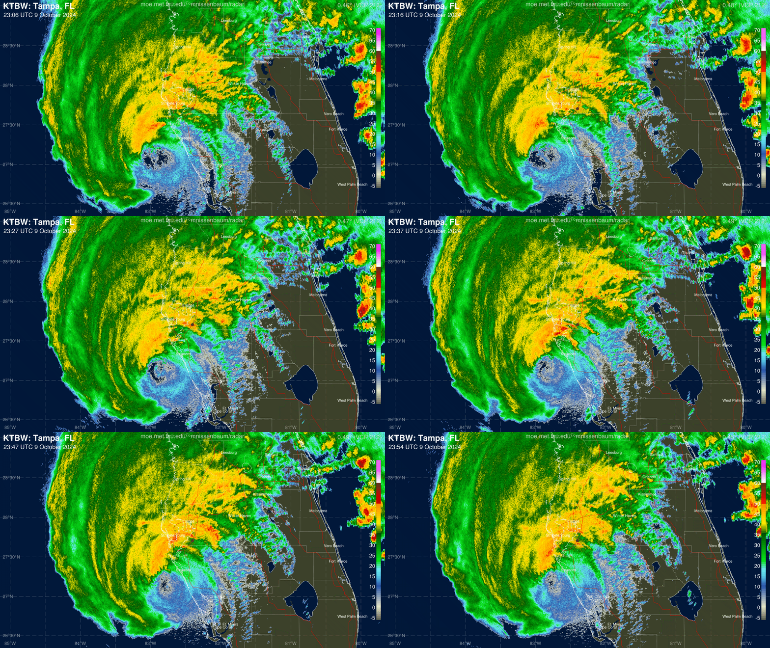
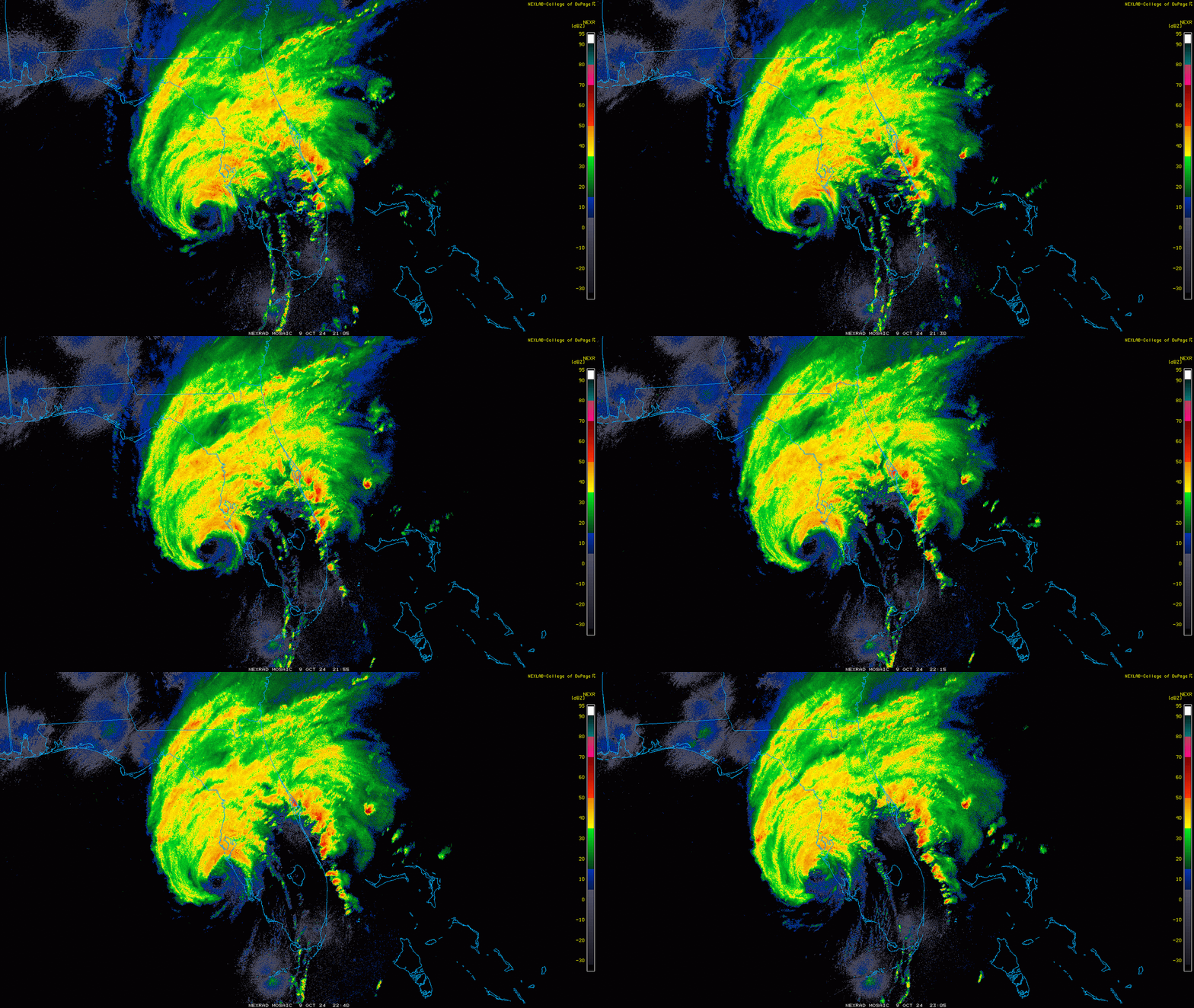
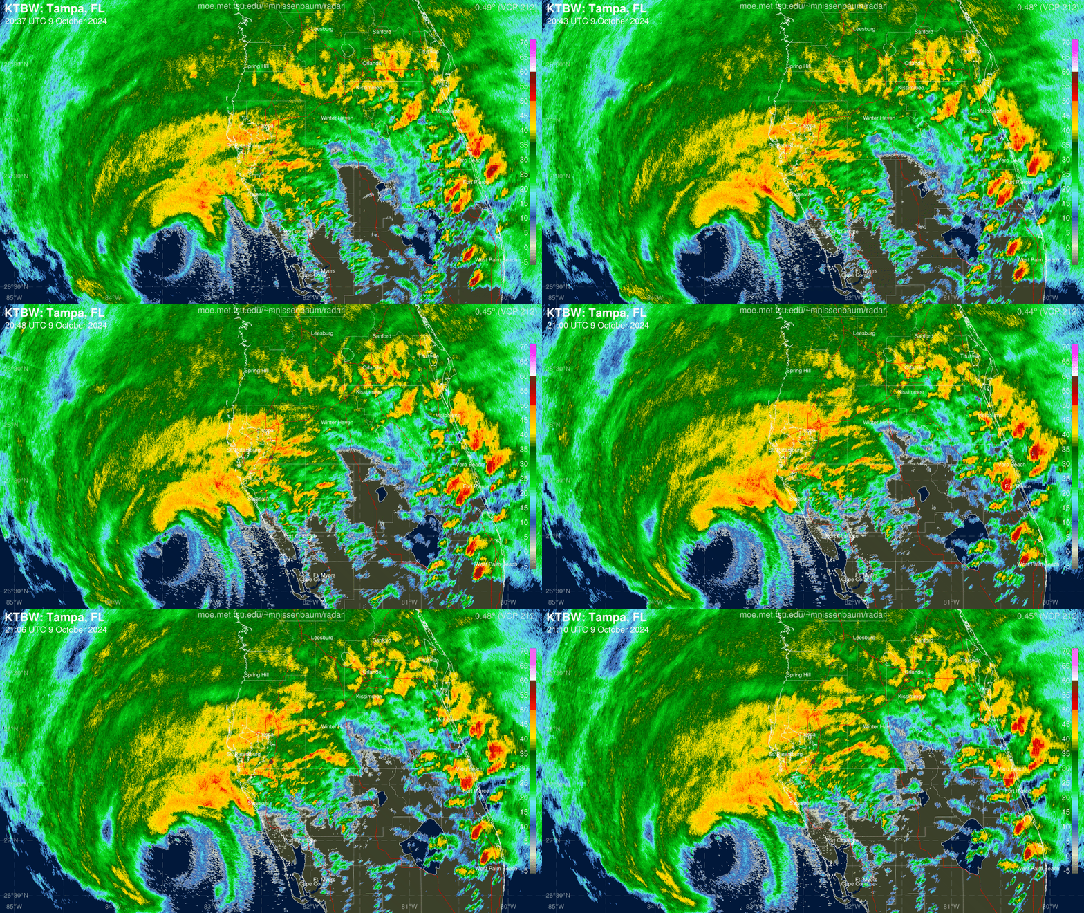
Finally, a couple looks from below via Doppler radar. First, a stateside composite showing the wet, windy northwestern half of the hurricane and drier southern half:
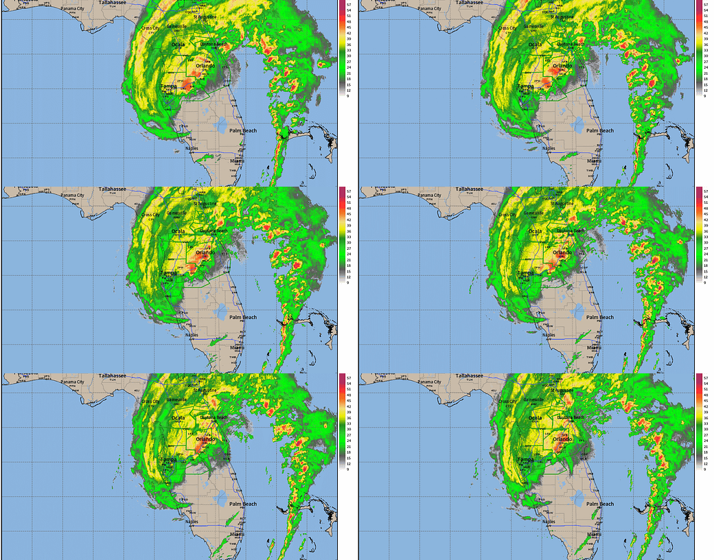
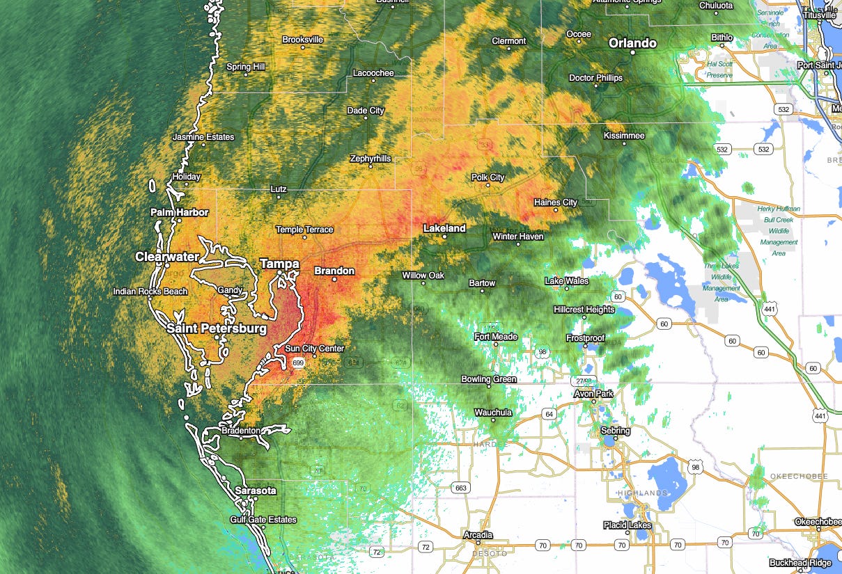
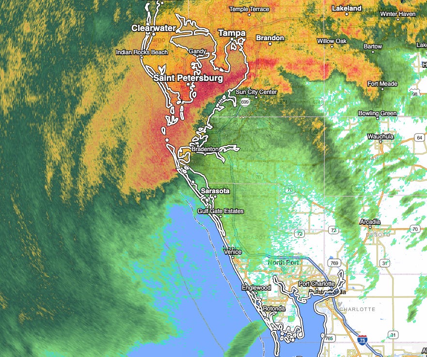
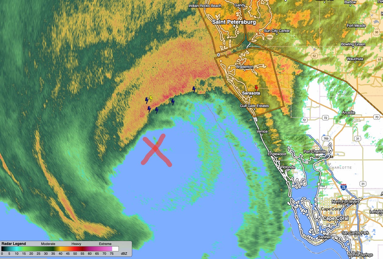
And finally, a close up look at west-central Florida, and Milton’s intense northern and western eyewall.
9:00p: Wind observations, NHC update
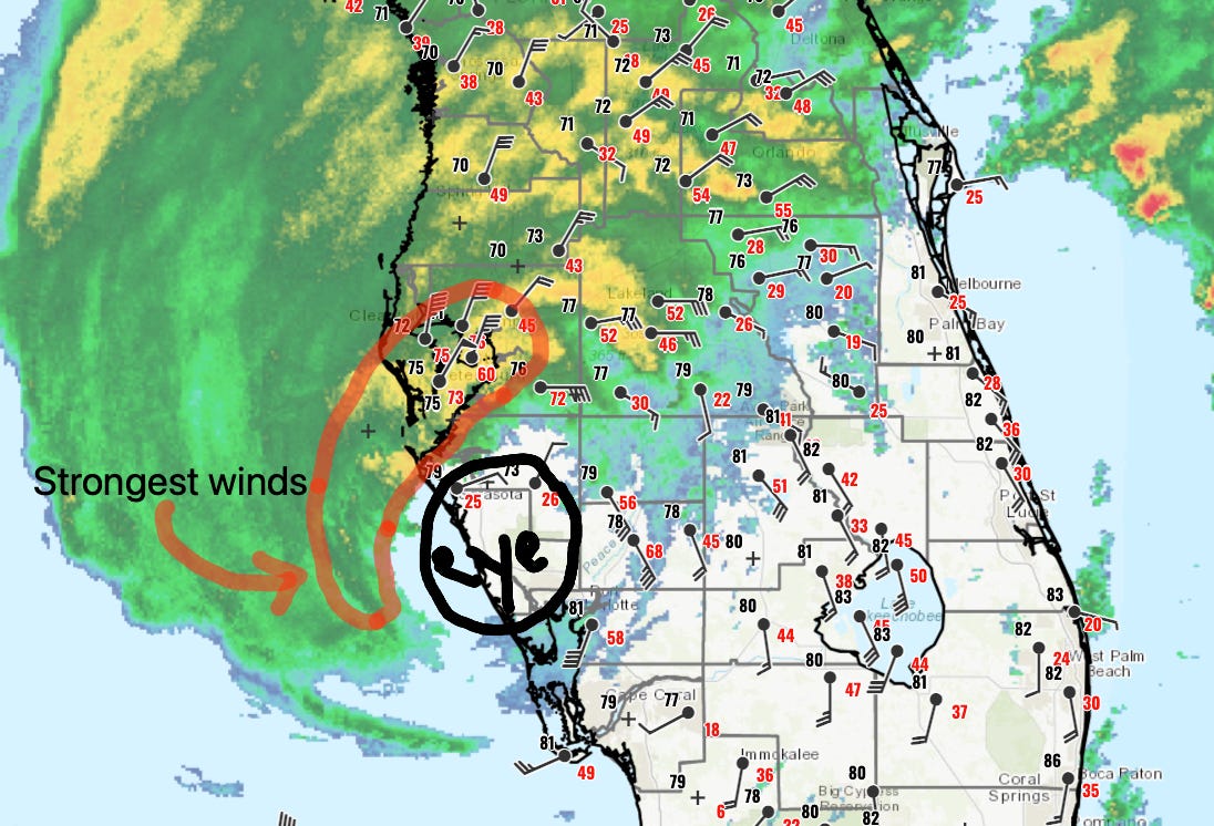
As the center of Milton moves east-northeast across Sarasota County, that region plus some of Manatee County are in the hurricane’s calmer eye. Due to the interaction of the hurricane with a front and a mid-latitude jet streak, all of the strongest winds are on the north and northwestern side of the storm. The Tampa Bay region continues to be experiencing the worst weather of Milton at this time, and another round of punishing winds will be moving back into the Bradenton, Sarasota, and Venice areas within 60-90 minutes as the western eyewall comes ashore.
This western and northwestern eyewall will likely bring the strongest winds of the hurricane to the west-central Florida coast between 10 p.m. and midnight. The NHC 9 p.m. update still finds 115 mph sustained winds and an east-northeast movement at 15 mph, with the center now 5 miles north of Sarasota. A wind gust of 102 mph was also noted at the Sunshine Skyway fishing pier at the mouth of Tampa Bay.
8:40p: Landfall confirmation
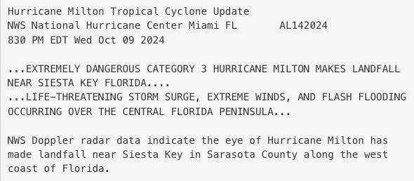
Milton, the 44th major hurricane landfall in Florida history since 1851, has officially come ashore near Siesta Key at 8:30 p.m. Estimated maximum sustained winds at landfall were 120 mph, a Category 3 on the Saffir-Simpson Hurricane Wind Scale.
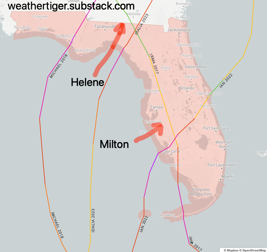
Incredibly, Milton is the sixth Category 3, 4, or 5 hurricane to make landfall on Florida’s Gulf Coast in just seven years. 2024 is also only the fifth hurricane season since 1851 with two major hurricane landfalls in the state, joining 1926, 1950, 2004, and 2005. Finally, this is the shortest time between consecutive major hurricane landfalls in Florida (if we don’t include the same hurricane hitting twice), coming just 13 days after Category 4 Hurricane Helene.
8:25p: Milton nearly onshore
With a wobble east, Milton is now minutes away from landfall at Sarasota, where a wind gust of 96 mph was reported in the eastern eyewall at 7:41 p.m. Winds are now falling there as Sarasota moves into the eye and pressure bottoms out around 959 millibars. The vicious northern and northwestern eyewall is over Tampa Bay, though fortunately those winds are mostly blowing water out of the bay.
Standby for confirmation of landfall from the NHC.
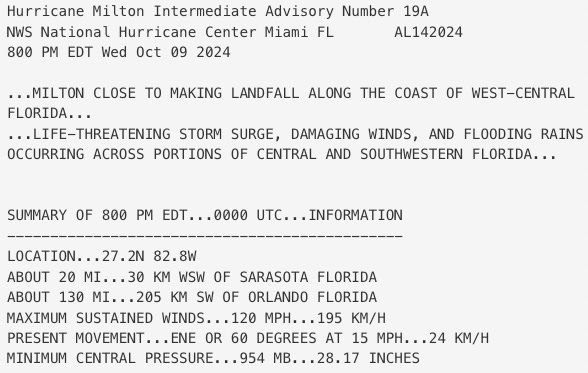
8:00p: New NHC intermediate advisory
The NHC’s 8 p.m. advisory is out, with little change from the previous information we had. Estimated minimum central pressure is up a couple ticks to 954 millibars, and motion is now east-northeast (60 degrees) at 15 mph, with the center located just 20 miles west-southwest of Sarasota. Sustained winds are still estimated at 120 mph.
Checking on the broader radar loop, Category 3 Milton’s inner core is now pushing into the Metro Tampa/St. Pete area to the north and the Charlotte Harbor area to the south. Extreme winds are raking this section of the coast and will continue to do so until past midnight as the western eyewall is quite intense. Portions of Sarasota County will start to enter Milton’s calmer eye in the next hour, with Milton’s actual center crossing land between 9 and 10 p.m.
7:40p: Final approach to landfall
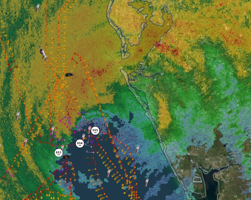
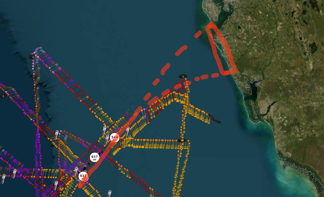
Two Hurricane Hunter aircraft are now engaged in “Shore Patrol,” flying back and forth to take last-minute data on Milton’s eyewall and center in the hours just prior to landfall. Center fixes continue to show Milton moving east-northeast, now within a couple of hours from crossing the coast near Sarasota.
Surge is rising along the west-central Florida coastline in the landfall zone, but because the winds are still mostly along rather than onshore north of Charlotte Harbor, the real rush of water likely remains ahead. To the north, powerful winds are sweeping the Tampa Bay area, still under the Extreme Wind Warning, with an airport in Pinellas County reporting an 89 mph gust at 7:25 p.m.
7:20p: Flooding rain threat for I-4 corridor
As Milton’s intense core interacts with the fast jet stream winds to its north, the eyewall is starting to take on a stretched appearance, angling downshear from southwest to northeast. That jet interaction is also causing basically all the rainfall to be on the northwestern half of the storm, as dry air chokes out all but intermittent bands of showers over the southern third of the peninsula. On the drier side of the hurricane, even the eastern eyewall pushing through Charlotte Harbor and Sarasota has relatively little rain with it, though reports of intense winds are still emerging.
With the focus of heavy rainfall likely to continue on the northern and western halves of Milton overnight, the National Weather Service continues to expect an additional 8-12” of rainfall along and just north of the I-4 corridor. That includes Orlando and Tampa metro areas, which remain at high risk of flash and urban flooding through tomorrow morning.
7:05p: Sunset on Milton; NHC updates
As the sun sets on Hurricane Milton, the first major hurricane to strike between Cedar Key and Charlotte Harbor in 103 years, the NHC has issued their 7 p.m. position estimate. This statement confirms the turn I discussed last hour, with motion now on a 55 degree heading at 15 mph versus 45/15 last hour. Center position is 35 miles west-southwest of Sarasota, and sustained winds remain near 120 mph— still a Category 3 hurricane on the Saffir-Simpson Hurricane Wind Scale.
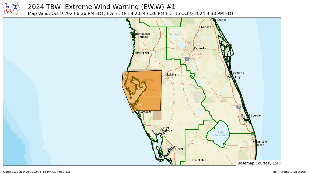
6:45p: Extreme Wind Warning for Tampa Bay
The Tampa Bay National Weather Service office has issued an Extreme Wind Warning for all of Pinellas, Hillsborough, and Manatee Counties. This is an extremely rare warning issued only when non-tornadic winds exceeding 115 mph are possible.
Treat this warning, which lasts until 9:30 p.m., as you would a Tornado Warning and seek shelter in an interior room. Wearing helmets to protect your head against treefalls is not a bad idea, either.
6:35p: Recon shows Milton turning
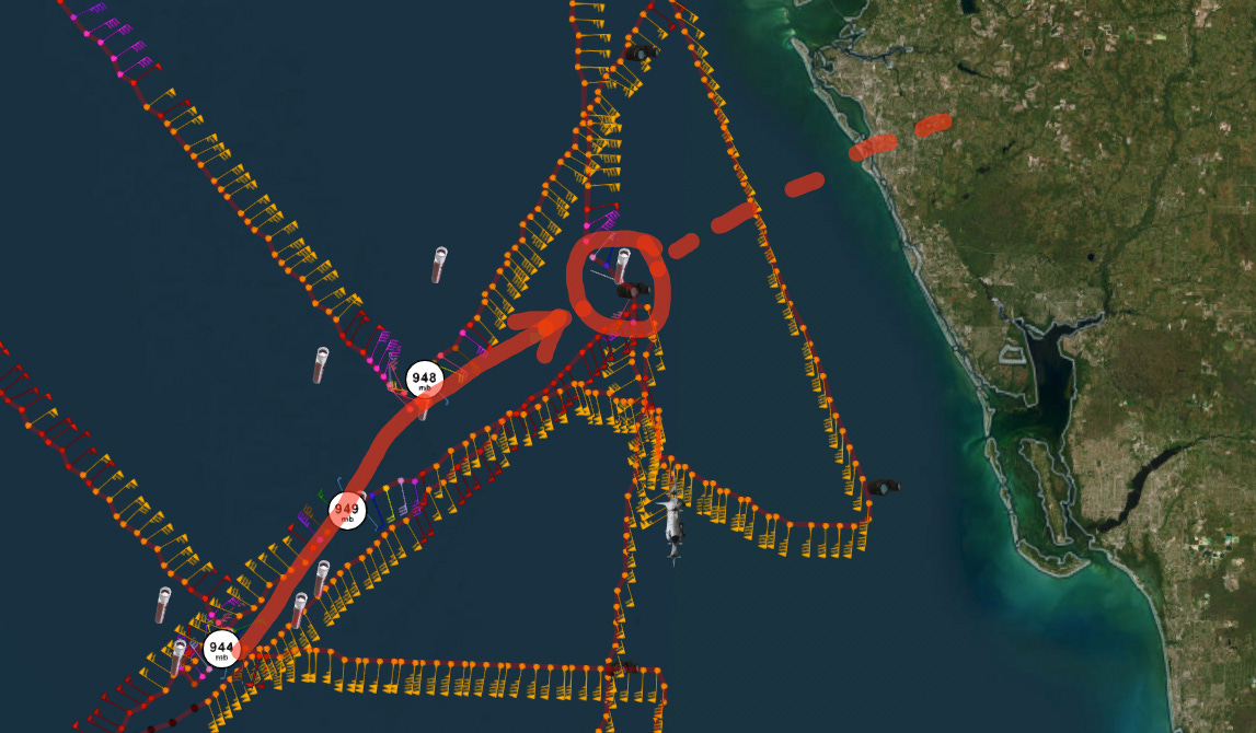
A fresh recon flight has just crossed the center of Milton in the past half hour, finding that the hurricane now appears to be making its expected turn to the east-northeast. Over the past two hours, Milton has tracked at a heading of more like 60 degrees, or east-northeastward, at about 15 mph. If this heading persists, that would bring the center of circulation to landfall at Sarasota around 9 p.m. or so. Sarasota Airport just reported a 77 mph wind gust, so conditions are deteriorating there as expected.
This rather definitive turn puts a center track into Tampa Bay out of reach, unless something drastic happens in the next hour or two. That’s good news for Hillsborough and Pinellas County, as it eliminates the worst-case surge scenarios for Tampa Bay proper. However, radar indicates that the very intense northern and northwestern eyewall are angling towards the Bay Area through midnight, likely packing winds of over 100 mph. A very damaging wind event looks probable for at least the southern half of the Tampa/St. Pete metro area.
6:10p: NHC update; Sarasota under the gun
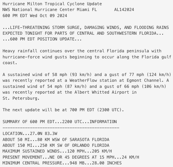
Per the NHC 6 p.m. update, Milton’s movement has shifted to the right and slowed down in the last hour, which is noticeable on radar as we await the next batch of Hurricane Hunter data. Movement is now estimated at true northeast (45 degrees) at 15 mph, slower and more eastward than the 35/17 last hour. The right turn is happening, albeit in the typical fits and starts. Overall, Milton seems to be following the NHC track for a landfall between Bradenton and Sarasota. Maximum sustained winds are down a blip to 120 mph.
The center of Milton is now just 50 miles west-southwest of Sarasota, and the worst conditions in the Bradenton, Sarasota, Venice, and Englewood area will be ramping up within the next hour or so as the center of Milton moves your direction. Expect structurally damaging wind gusts, possibly strongest when you get the other side of the eyewall late in the evening as Milton’s windfield is skewing north with shear. With the center tracking for Sarasota/Bradenton, these areas south to Charlotte Harbor will also see the very worst of Milton’s storm surge, which will come roaring ashore late tonight through early tomorrow morning as winds switch from being off- or alongshore (as now) to onshore, out of the west and southwest.
There is no reason to expect that the NHC 9-13’ surge range should not happen on this section of coast, at least from Sarasota and south.
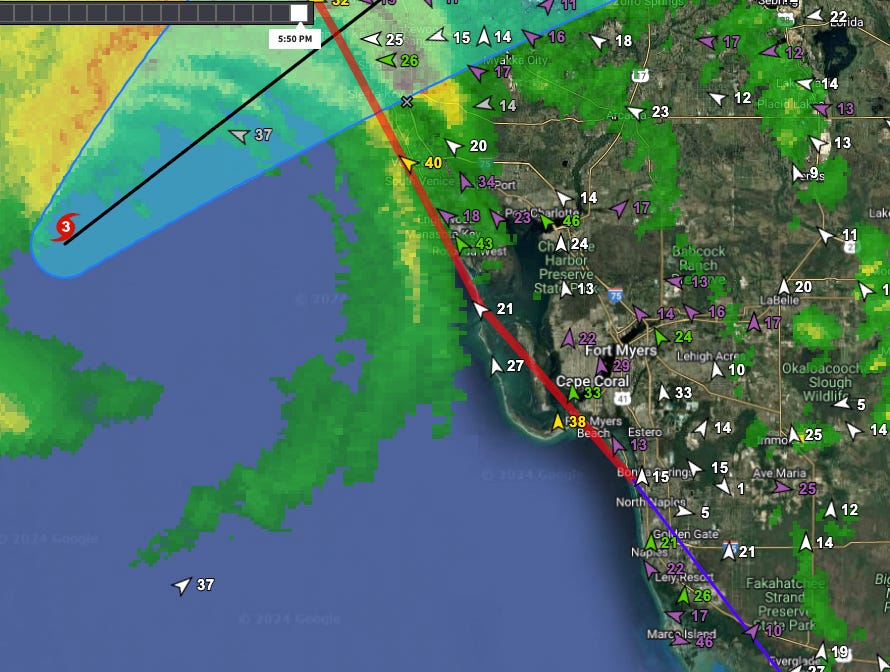
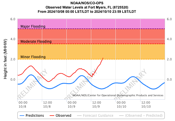
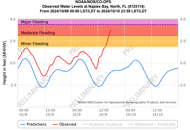
5:55p: Surge inbound to Fort Myers, Naples
As the eyewall approaches the west-central Florida coastline at a rapid clip, onshore winds out of the south are howling further south in Southwest Florida. Sustained tropical-storm-force winds are onshore in the Fort Myers area south to Naples. Sustained tropical-storm-force winds along the coast will continue into the early morning hours, turning increasingly out of west through the night as Milton’s center heads east-northeast across Central Florida, with hurricane-force probable along the coast, especially later tonight towards Fort Myers. However, there isn’t much rainfall in Southwest Florida and not a whole lot more is expected as dry air sweeps the southern half of Milton.
For surge, that shift in wind direction to the west will pile in the highest surge in Fort Myers and Naples through the early morning hours. Both reporting stations have already reached flood stage as of 6 p.m., and are expected to continue climbing this evening, even though the inner core of Milton will pass to SW Florida’s north.
New NHC position update coming soon.
5:35p: Conditions check
Turning our attention back to conditions on the ground, Milton is spreading the expected extremely heavy rainfall across north-central and central Florida in the late afternoon hours. This rain is heaviest in the Tampa Bay area, but steady and soaking in the Orlando area as well. Central Florida has already seen anywhere from 2-4” of rain just in the last six hours, heaviest in Pinellas, Manatee, and Sarasota where Flash Flood Warnings are in effect. Flash Flood Warnings also continue across much of south-central Florida.
With dry air wrapping into the southern half of the storm, rainfall is much more scattered near and south of Lake Okeechobee, though several Tornado Warnings remain in effect with supercell thunderstorms from Indian River south to Palm Beach Counties.
Winds are also picking up as Milton’s broadening core of strong winds reaches the west-central and Southwest Florida coastline. A weather station in the mouth of Tampa Bay is reporting sustained winds over 50 mph and gusts to 63 mph, and hurricane-force wind gusts are likely to start reaching the coast in the next hour between Charlotte Harbor and Tampa Bay.
5:00p: New NHC advisory
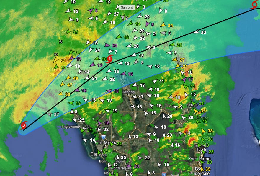
The NHC has issued their 5 p.m. advisory package, including a new position and intensity estimate, as well as updated track and intensity forecasts. Maximum sustained winds are now 120 mph, down 10 mph from the 2 p.m. update and making Milton a Category 3 storm. Milton is now just 65 miles west-southwest of Sarasota, tracking on an 35 degree heading at 17 mph. This is just north of true northeast.
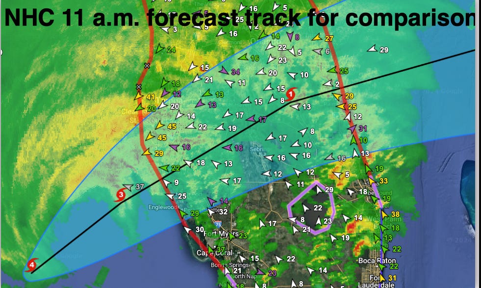
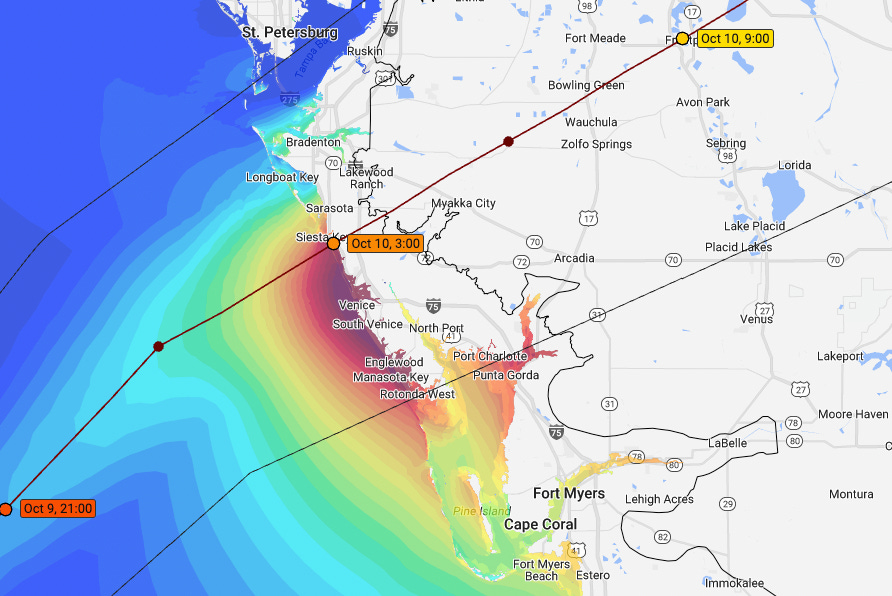
The next forecast point for 2 a.m. has Milton as a Category 1 near Lakeland, but the accompanying discussion product strongly indicates that NHC forecasters believe Milton will make landfall as a Category 3 hurricane within a matter of 4 to 5 hours. The new forecast track is shifted north from the 11 a.m. advisory, and is also faster than the previous forecast, now implying landfall between Sarasota and Bradenton. In comparison, the 11 a.m. NHC forecast track with a landfall point just south of Sarasota is shown below:
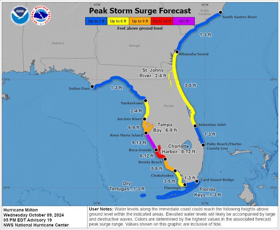
Bottom line is Milton is racing towards having a catastrophic surge impact on Bradenton south to Charlotte Harbor, and the jury remains out on the severity of the surge in Tampa, though the forecast track remains to your south. Reasonable worst case surge graphic from the NHC still has 6-9’ surge across Tampa Bay for this reason, with 9-13’ from Anna Maria Island south to Boca Grande.
Next post will take a closer look at current conditions across the state.
4:35p: Surge cases for Tampa, Southwest Florida
With another Hurricane Hunter center passage in the last half-hour, data continues to show that Milton is keeping a 30-35 degree heading for now. With a 45 degree heading from its current position to Anna Maria Island, Milton needs to slow down and make its expected right turn to avoid going directly into the mouth of Tampa Bay.
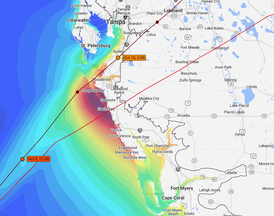
Whether or not this happens makes a big difference in Tampa Bay surge impacts. Here is CERA modeling for surge values if Milton follows the NHC 11 a.m. forecast towards a Sarasota landfall (yellows are 5’ surge, dark reds are 10’). In this scenario, the worst surge hammers Sarasota south to Charlotte Harbor, with severe coastal flooding south of Charlotte Harbor as well. In Tampa Bay, that scenario means relatively diminished surge versus the worst-case scenarios, due to strong offshore winds.
However, if the track shifted north to a landfall point near or north of Bradenton, Tampa Bay, especially eastern shores, would see severe storm surge. Extreme surge values of 8-12’ would still occur in Sarasota, Venice, and Charlotte Harbor in this case as well. Milton may have slowed in the last few radar frames, so a turn still could be coming. But, as I’ve said before, Tampa Bay remains in wobble range of surge is tracking for a severe wind event.
4:00p: NHC seeing speedup; Milton from space
At the 4 o’clock hour, the NHC is also seeing the acceleration I mentioned in my previous post. The 4 p.m. Tropical Cyclone Update bumps the hurricane’s forward motion up a mile per hour, and Milton is estimated to be still moving on a heading of 35 degrees at 17 mph, compared with 35/16 at 3 p.m. We will see how this may change their landfall point forecast and inland trajectory in the 5 p.m. advisory package, but I would look for an earlier and possibly slightly further north track than at 11 a.m.
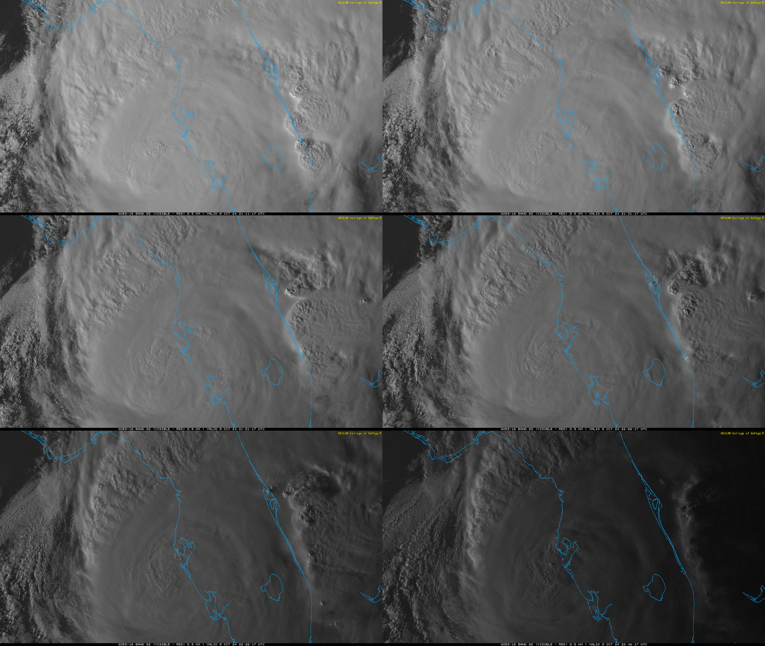
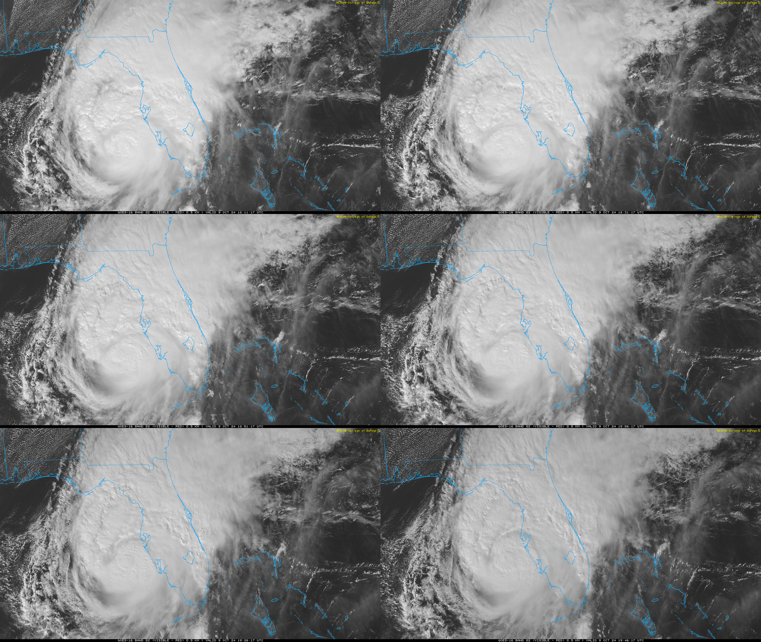
Stepping back to look at Milton from space, the hurricane is unfortunately continuing to generate strong core convection per visible satellite imagery as it races towards land. That indicates that Milton has not lost a well-organized core this afternoon, and will remain a powerful major hurricane through landfall in west-central Florida.
3:25p: Milton speeding along; wobble watch
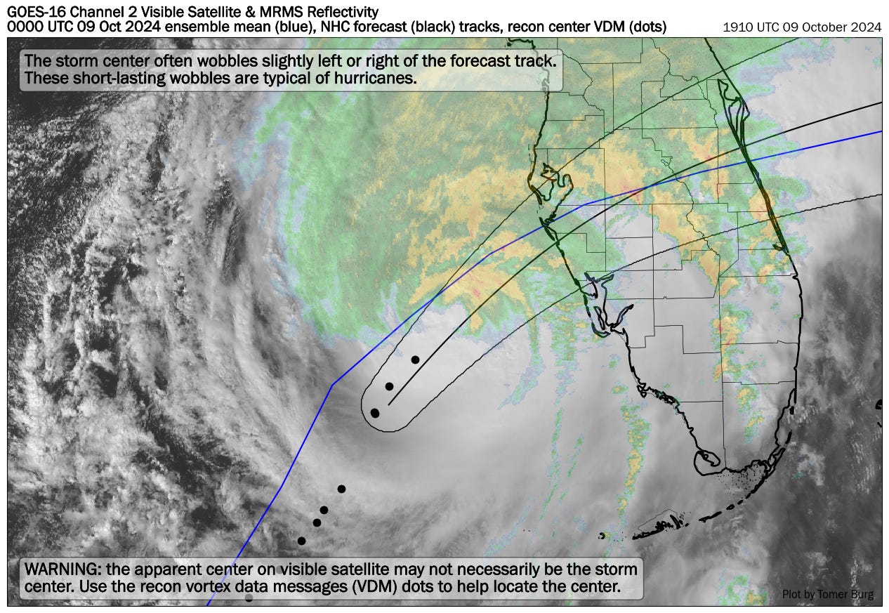
As I discussed yesterday, one of the most agonizing aspects of Milton’s forecast was that it would be likely be unknown if Tampa Bay would take a direct hit from the hurricane, or whether a track south would spare it the worst-case surge until hours before landfall. Well, just hours before landfall, Tampa Bay is still north of the NHC forecast track, but it is very much in “wobble range” of the center possibly moving into the Bay, with any small northward deviations in track.
Calculating Milton’s movements in real-time using Hurricane Hunter data, the hurricane has moved on a heading of about 40 degrees over the last three hours, at a speed of a little less than 20 miles per hour. If Milton continued that heading, it would reach the coast near the mouth of Tampa Bay (Anna Maria Island) around 8 p.m. The heading from its current position to Sarasota is 50-55 degrees, and 60-65 degrees to Venice. Some slowing down and eastward turning is expected over the next few hours, but based on what I’m seeing, probable landfall is between Anna Maria Island and Venice between 8 and 11 p.m. tonight, faster than expected.
Tampa Bay, you are in for a severe wind event, and not out of the woods for surge. Next post a little after 4.
3:05p: Wind check, NHC update
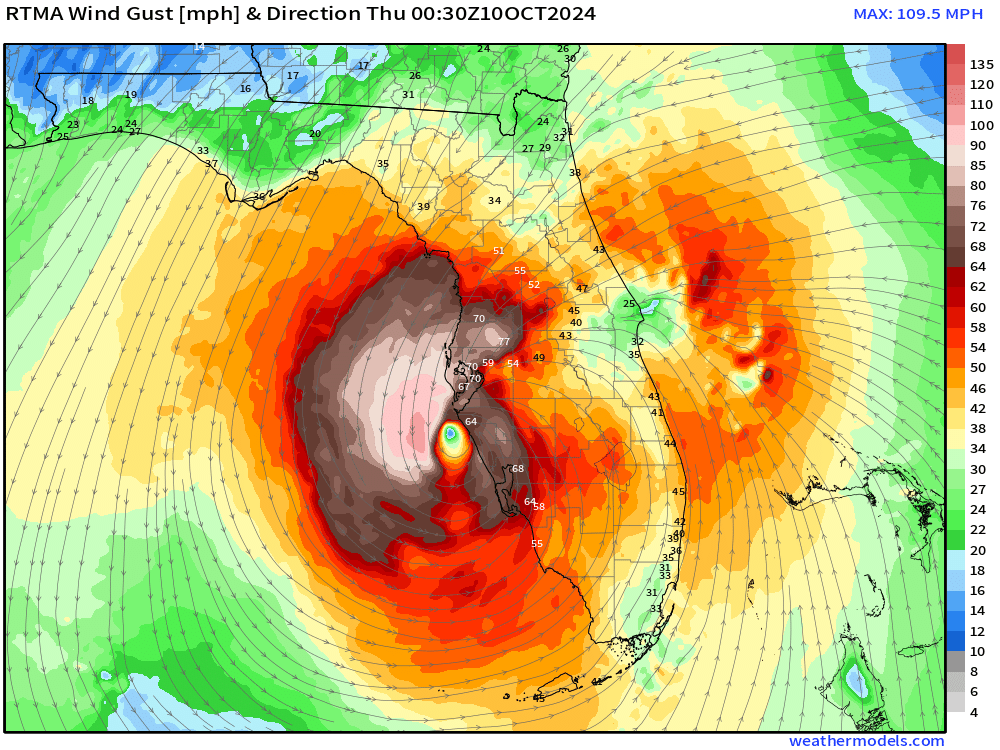
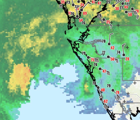
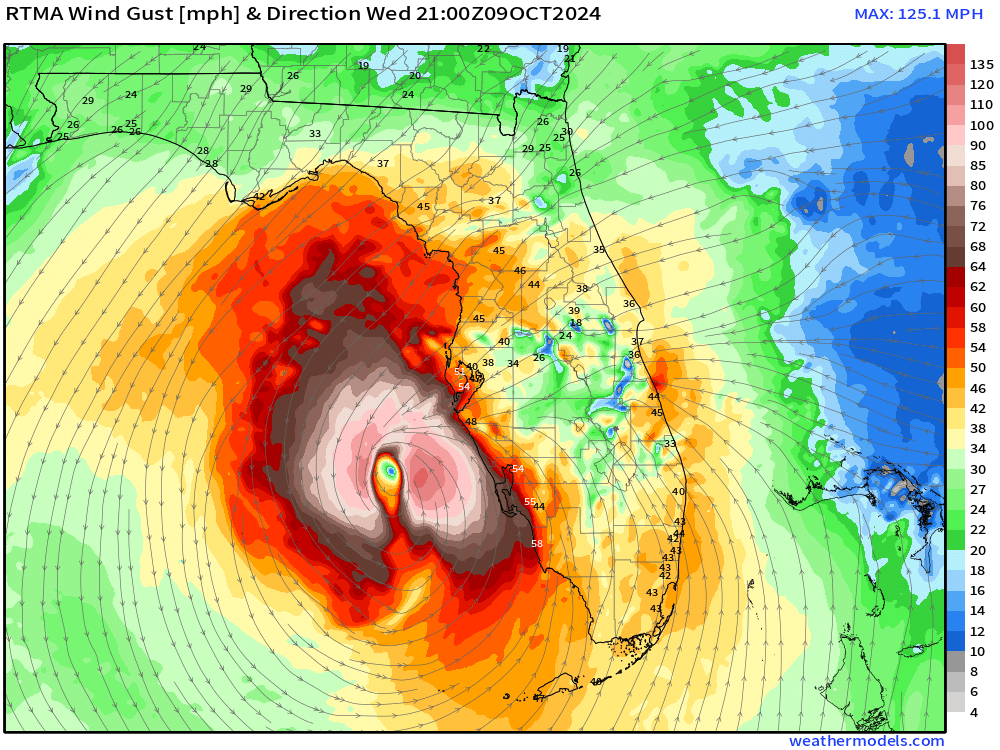
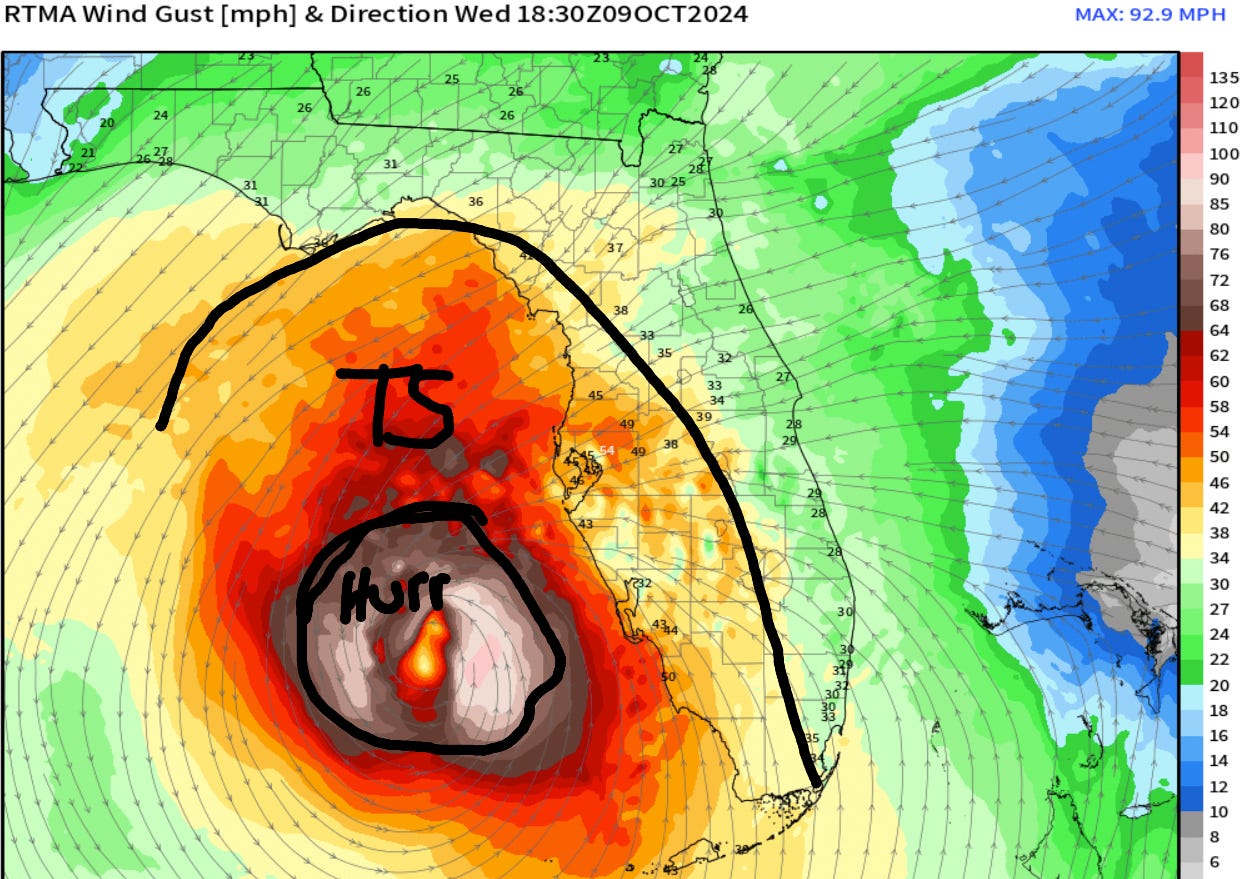
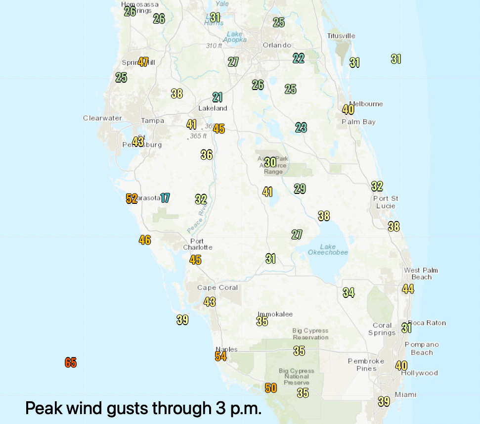
Milton may not be quite as large as Helene, but its windfield is expanding notably as it tracks northeast. The 2:30 pm NWS wind gust snapshot above shows Milton’s 350-mile wide tropical-storm-force wind diameter in full effect and overspreading west-central Florida and Southwest Florida. Hurricane-force winds as measured by recon aircraft span about a 70-mile diameter and remain offshore for now. As of 2:50 p.m., observed peak gusts so far today across Central and South Florida have generally been in the 35-45 mph range, with top gusts in the 45-65 mph range on the Southwest and west-central Florida coasts from Tampa Bay and south.
The 3 p.m. hourly position and intensity estimate from the NHC finds Milton still a Category 4 hurricane, with sustained winds of 130 mph. Motion continues on an 35 degree (northeast) heading at 16 mph. Next post will discuss how important each tick of latitude is to the impacts outcome in west-central Florida, and what I’m seeing now.
2:35p: Tornado outbreak, intermediate advisory
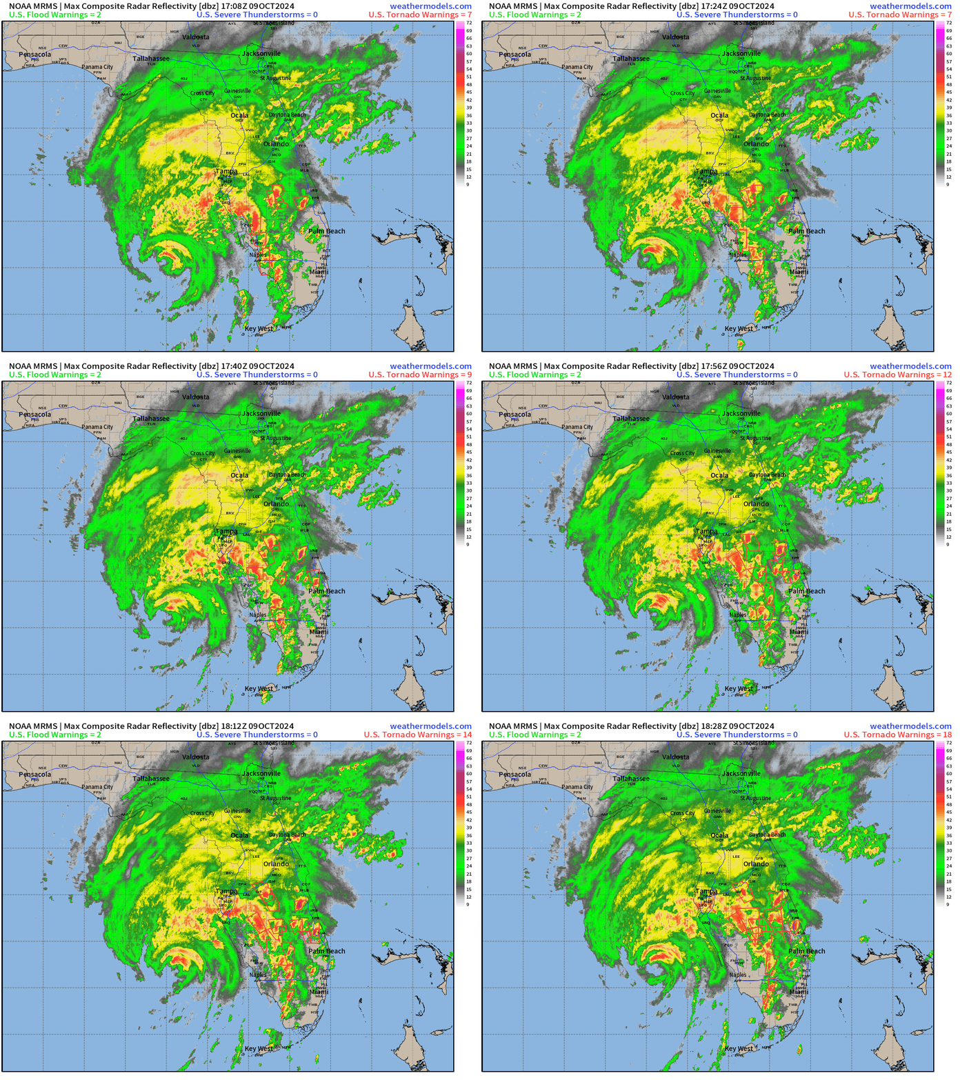
If you had a chance to watch my forecast video, you know a focus of it was the ongoing, significant tornado outbreak across south-central and South Florida this afternoon. Looking at radar as of 2:30 p.m., there are numerous Tornado Warnings in effect, most concentrated in the area just north of Lake Okeechobee. Tornadoes embedded in the outer bands of hurricanes are a common occurrence on the east side of storms, and unfortunately we are seeing that with Milton today. If you receive a Tornado Warning, go quickly to an interior room and stay there until the warning ends. Tornado Watches, indicating that conditions are favorable for tornado development, are in effect for all of Central and South Florida. Check the Storm Prediction Center for the latest watches and your local National Weather Service forecast office for the latest Tornado Warnings (plus lots of other great information).
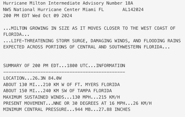
Additionally, the NHC has issued the 2 p.m. intermediate advisory for Milton. Unlike the full advisory packages typically issued at 5 and 11 a.m. and 5 and 11 p.m., there is not an updated track and intensity forecast with intermediate advisories. These are issued at the 3-hour point (the 2s and 8s) to update intensity, positions, and warnings.
Takeaway here from the 2 p.m. advisory is that Milton’s estimated sustained winds are now 130 mph, Category 4 status on the Saffir-Simpson Hurricane Wind Scale. Pressure as measured by NOAA Hurricane Hunters continues to rise, and is now about 945 millibars. Bottom line this afternoon is Milton is spreading out its windfield as maximum sustained winds come down in response to shear, as expected. It remains an extraordinarily dangerous storm. You can read the advisory here.
2:00p: Forecast video and welcome
Welcome to WeatherTiger’s Hurricane Milton landfall live blog. If you’ve never read the Hurricane Watch prior to today, I’m Ryan Truchelut, Chief Meteorologist at WeatherTiger, a Tallahassee-based weather newsletter and consulting company. By my native Central Floridian roots, in earning a doctoral degree in meteorology from FSU, and through twenty years of real-world hurricane forecasting experience, I’ve prepared for days like this my entire life.
And days like this keep happening. In just the past seven years, I’ve liveblogged the landfalls of Irma, Michael, Ian, Laura, Idalia, and, less than two weeks ago, Category 4 Hurricane Helene’s siege of North and Central Florida. Frankly, I wish I had a bit little less hard-knocks forecasting experience, if you know what I mean.
Over the next 12 hours or so, I’ll be frequently updating this page with minute-by-minute meteorological developments: the latest NHC advisories, National Weather Service warnings, local observations from across Florida, and forecasting insights on all aspects of this catastrophic storm. My goal is to keep you safe by providing accurate, no-hype, real-time information through the time Milton is inland and weakening and we have a good idea how impacts will play out.
To get you up to speed on what’s going on with Milton right now, I’ve just completed a forecast video which you can watch at the link below. It has my latest thoughts on the timing, location, and severity of surge, wind, and rain impacts across the state, which I’ll also be sharing and expanding on in future posts.
Folks, I know we’re already bruised and broken from Helene. Today and tomorrow are going to be bad days in Central and North-Central Florida, and my heart goes out to everyone in the path of this storm, from an exhausted North Floridian. I’m from Orlando and have many, many friends and family connections there as well as in the Tampa Bay area and Southwest Florida. My job is to try to make your awful experience a little less awful and more manageable by giving you informed straight talk on what’s going to happen and when with Milton. We’ll get through this together, with heart and hustle.
I’ll be back around 2:30 to start rattling through current conditions and the threats ahead. Keep watching the skies.



Thank you again for the continuous blog…
I have friends & family scattered thru out this state… your information was very appreciated!
As usual, you were spot on about the tornado threat in South FL. I’m in Martin County. Had two tornadoes touch down within a mile of me on either side. Monkey in the middle…yikes! Power immediately went out…just as we started getting the first bands through. All my years in IL…never heard of that many tornadoes in such a short period of time. Thanks for the great work!