WeatherTiger's U.S. Hurricane Landfall Risk Outlook for August 2024
When your forecast for elevated hurricane activity is delayed by elevated hurricane activity, it's not a great sign. A busy peak of the season is likely ahead.
Back in the spring, when early indications began to signal a hyperactive hurricane season ahead, I took action. Repurposing a Staples “easy button” with the words RESET SIMULATION, I headed down to Steinhatchee, FL, where Category 3 Hurricane Idalia defied climatology and struck last August. At scenic Steinhatchee Falls, I pressed my improvised reset button, thus attempting to end the Gulf Coast’s decade-long hurricane glut by turning the Atlantic off and back on.
That was easy, but not effective. Since this symbolic protest, sea surface temperatures have soared, a Category 5 has stalked the Caribbean, Steinhatchee has been hit by yet another hurricane, and both scientific and vibes-shift methodologies suggest that a frenetic peak of the 2024 hurricane season will kick off over the next couple of weeks.
What’s happened so far?
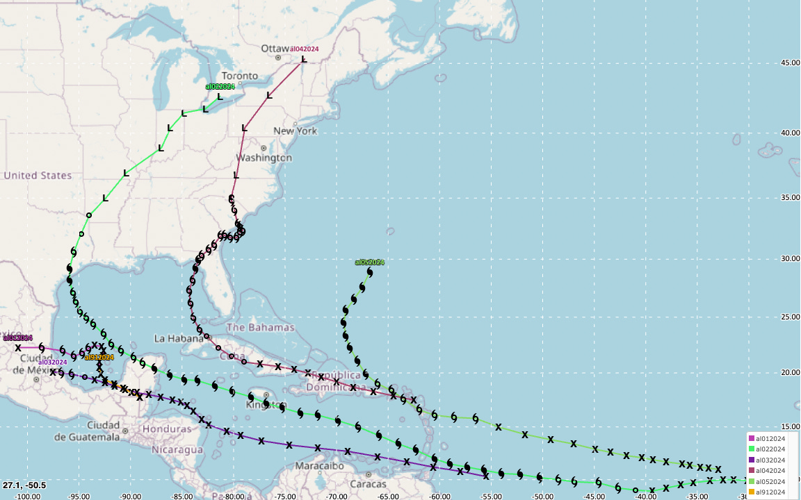
To date, the 2024 hurricane season has produced five named storms, three hurricanes, and one major hurricane. After ongoing Hurricane Ernesto (a threat to Bermuda and Atlantic Canada) washes out early next week, the Atlantic will have tallied about 60% of the storm energy of an average hurricane season, or four times what’s typical so far.
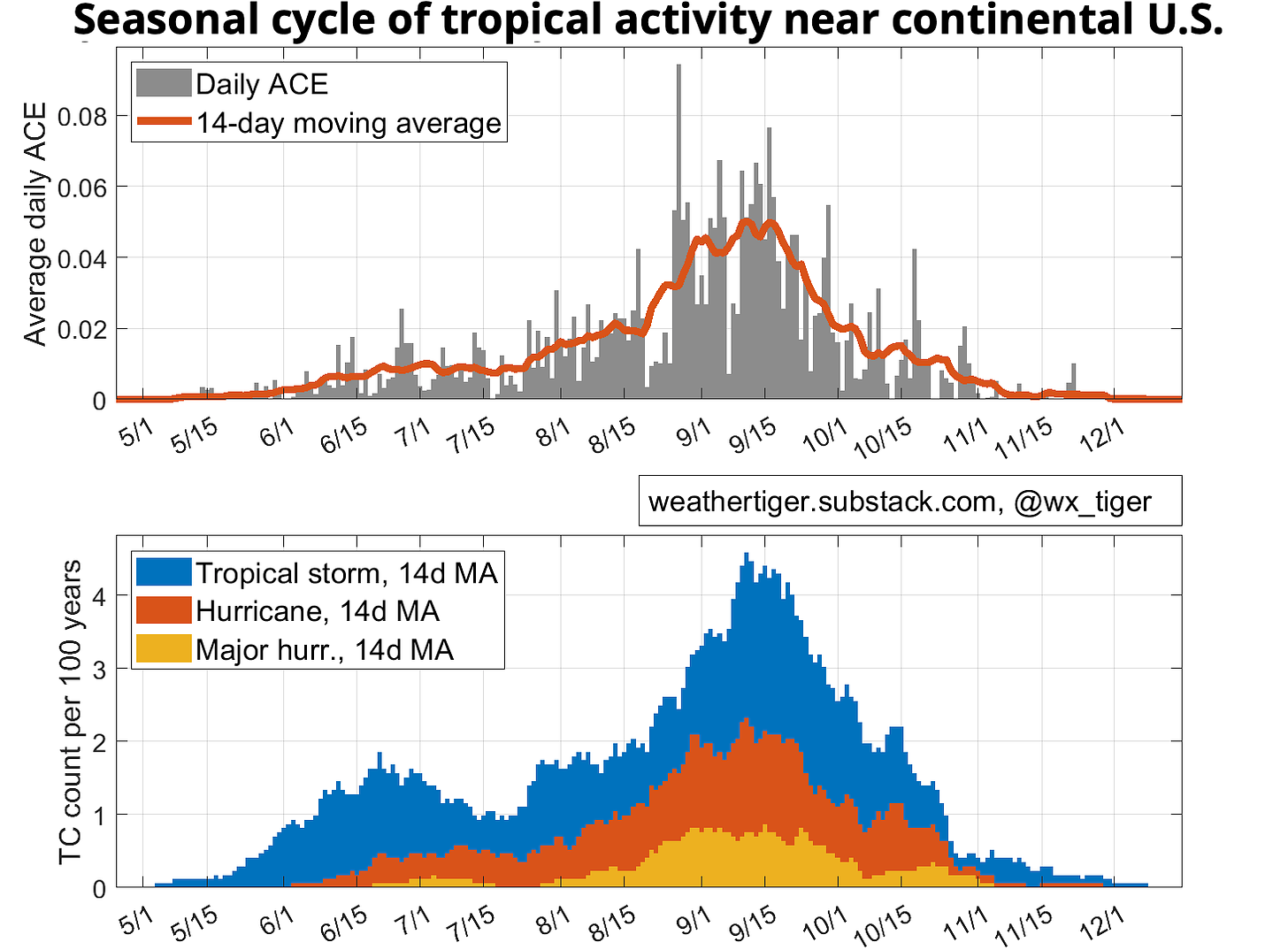
All five of these storms have struck land, including two Category 1 landfalls on the beleaguered Gulf Coast: Beryl in Texas, and Debby in Florida. The average number of continental U.S. hurricane landfalls in a season is just under two; 70% of historical hurricane landfalls and over 80% of major hurricane strikes have occurred after 8/20.
While 2024 has mocked attempts at a reset, the good news is that there are no threats on the horizon in the wake of Ernesto. While many supportive factors for storm development are in place, the Atlantic remains awash in enough dry air and Saharan dust to exsanguinate tropical waves for now. This should change sometime in the last week of August. With that breathing room, today I’m refreshing WeatherTiger’s seasonal outlook, with a particular focus on U.S. landfall risks. Trying to predict steering patterns is tricky and uncertain, but unlike Staples, we do these things not because they are easy, but because they are hard.
Overall activity forecast
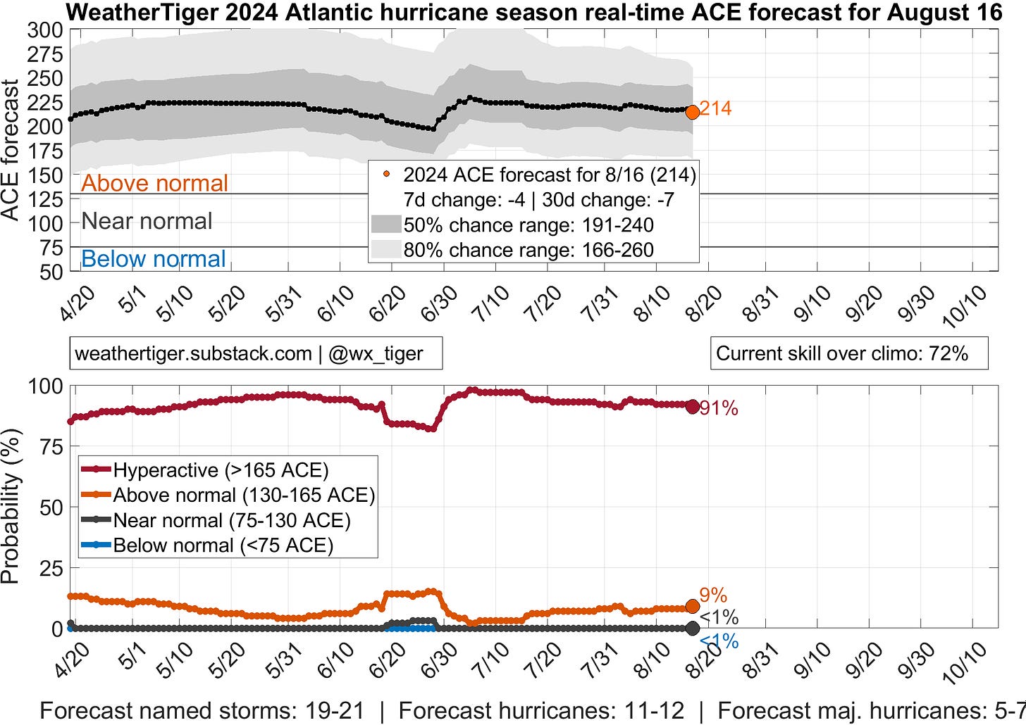
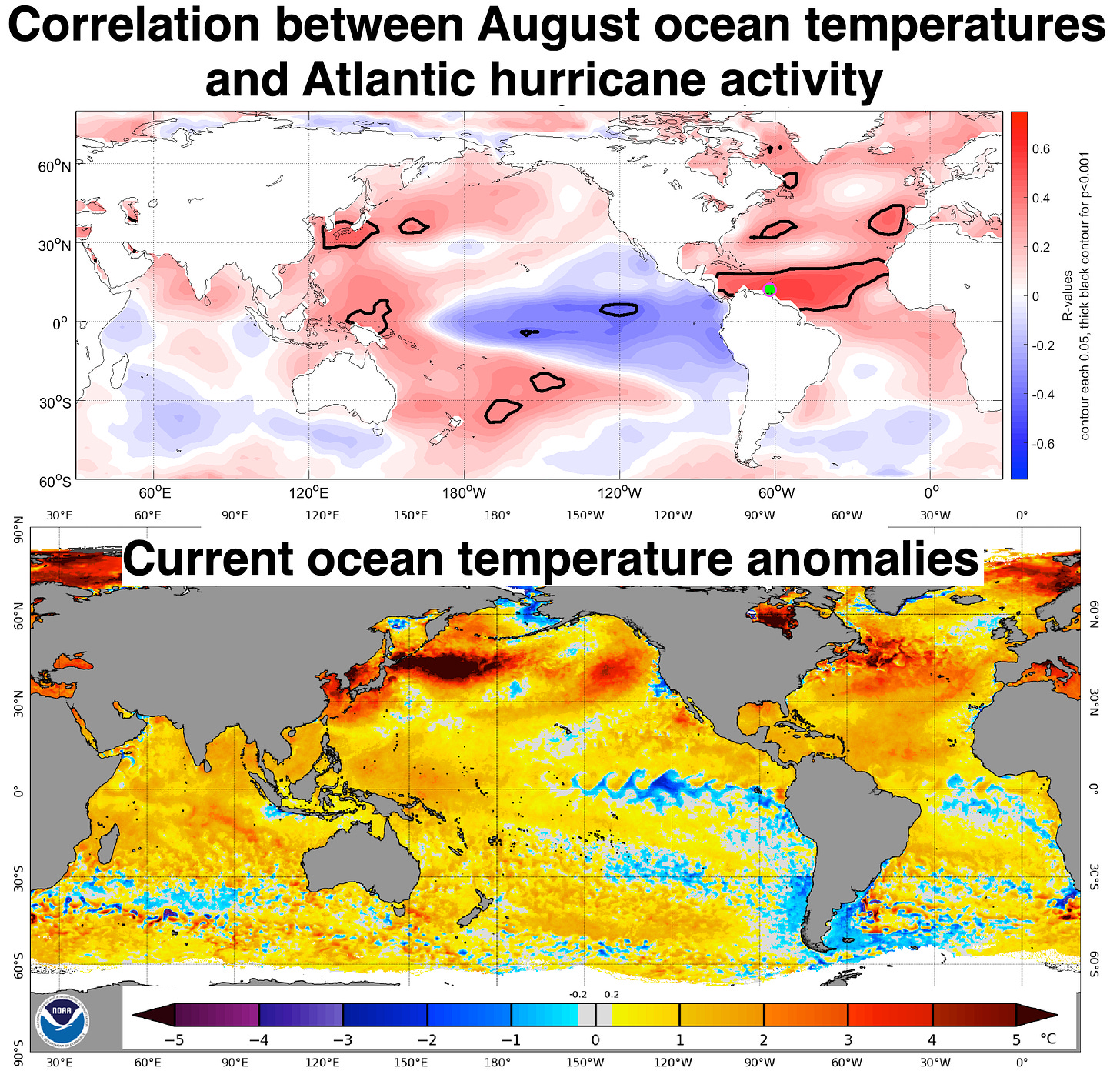
I’m not going to focus on the overall activity forecast, both because it doesn’t always translate to U.S. landfall risks, and also little has changed about our predictions for the 2024 season since March. The fundamental underpinnings of our earlier outlooks remain steady. First, the portions of the Tropical Atlantic where elevated sea surface temperatures and busy seasons are linked are all at least 1-2F warmer than average. Second, the Pacific continues a slow descent towards La Nina conditions. These influences support favorable oceanic and atmospheric conditions for Atlantic hurricane development, respectively, during the September apogee of the season. We can also throw a few more strong indications of a busy peak onto the pile, including weak low-level trade winds across the Tropical Atlantic in July and August.
WeatherTiger’s seasonal forecast algorithm quantifies these predictors and others to produce optimized odds of how hurricane season may play out (these probabilities update daily here). As has been true since March, there remains around a 90% chance of a hyperactive hurricane season with at least two-thirds more tropical activity than normal, and a most likely outcome of over twice the average activity. The 2024 season has 50-50 odds of landing in the 19-21 named storm, 10-12 hurricane, and 5-7 major hurricane ranges, including what has already occurred.
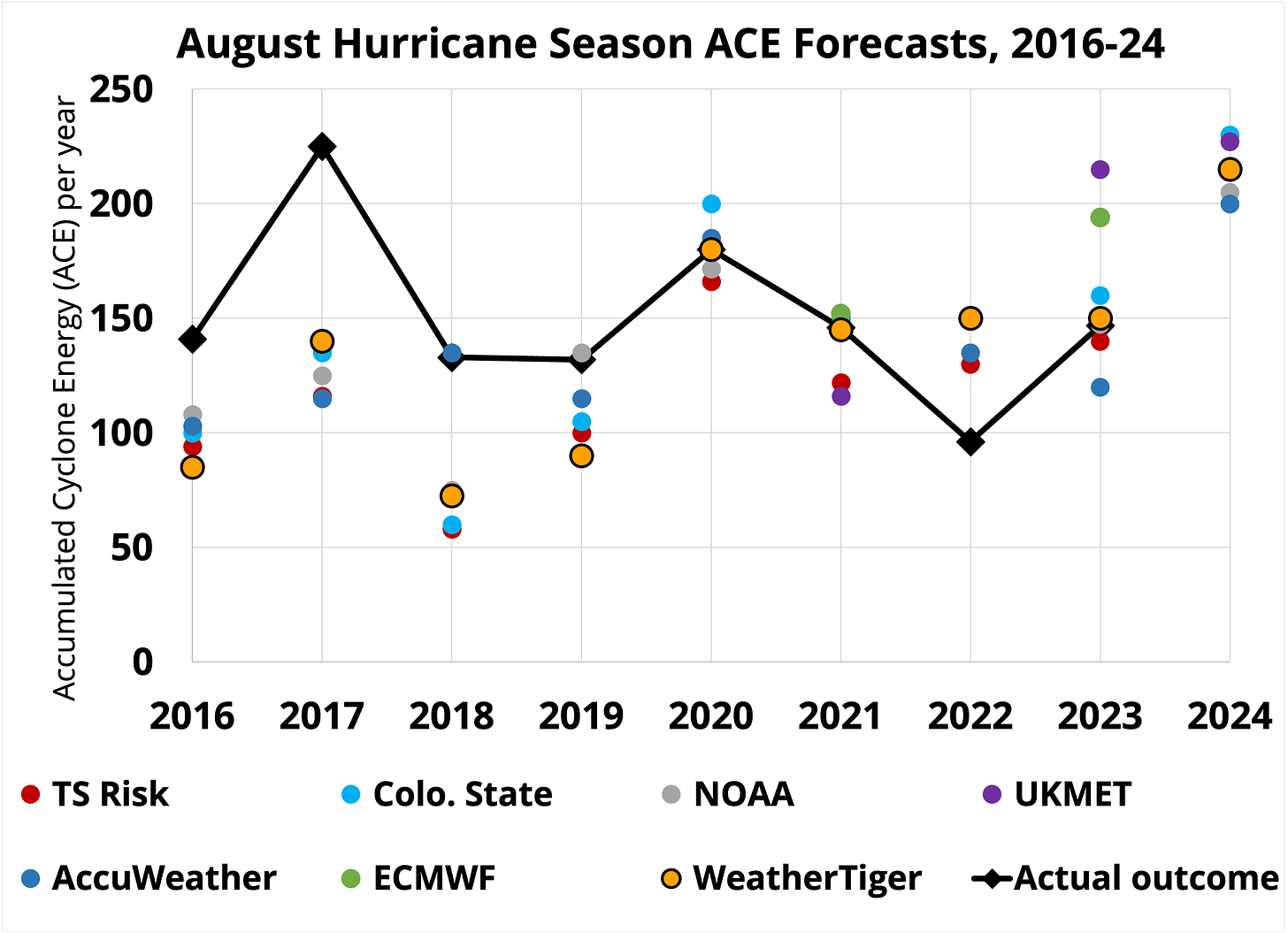
We continue to be in good company in these predictions. All major forecasters, including NOAA and Colorado State, issued their most aggressive August outlooks ever, with a strong consensus for around twice normal activity or just a bit more. WeatherTiger’s forecast numbers are solidly in the middle of that pack. As shown above, while sometimes all the projections are wrong in the same general way, only once in the past decade has the seasonal forecast consensus missed high (2022).
U.S. landfall risks forecast
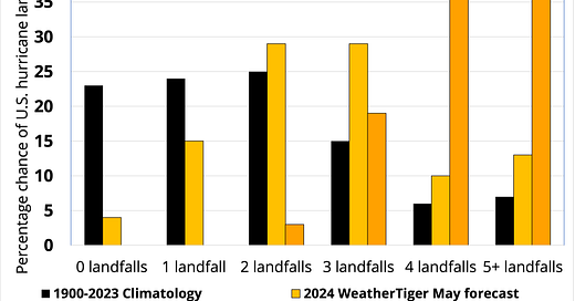
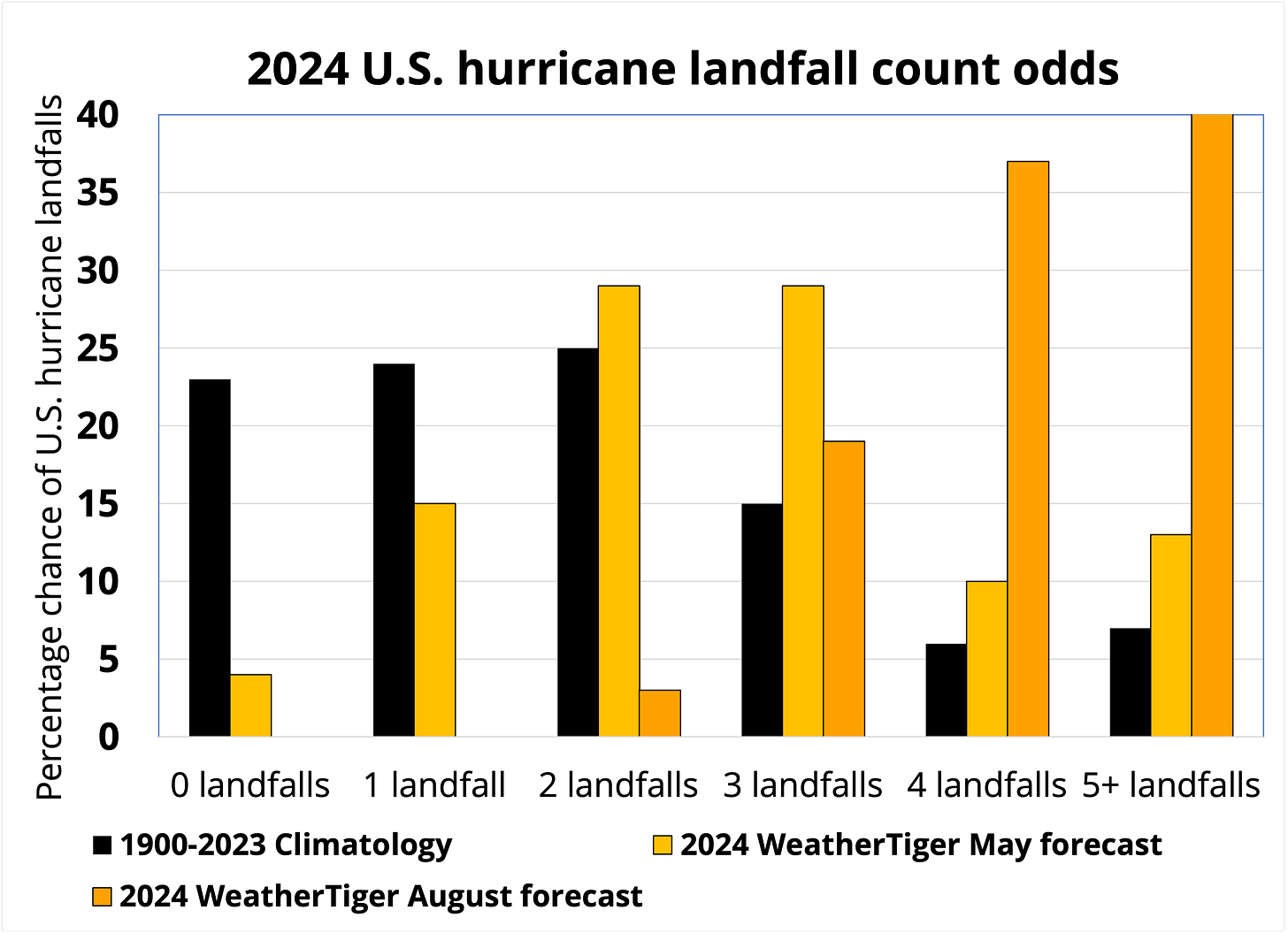
Unlike the overall activity projection, WeatherTiger’s seasonal forecast for U.S. hurricane landfalls has changed quite a bit since late May. One reason for this is that Beryl and Debby have already struck, but there are also hints that the steering pattern during the peak months of hurricane season will be intermittently (if not consistently) favorable for bringing some of that activity surplus towards the continental U.S. Together, these changes shift the most likely number of continental U.S. hurricanes from May’s 2 to 4 range up to 4 to 5, well above the typical 1 to 3 landfalls.

As I touched on in May, predicting seasonal landfall risks is tough because the ocean and atmospheric patterns that foment more tropical activity seem to also favor proportionately less of that activity reaching the United States. As shown above, cooler sea surface temperatures in the Tropical Atlantic in August tend to mean that a higher percentage of what develops strikes land. As the four to seven people who have read my dissertation are aware, another key to steering regimes is what’s going on along the U.S. West Coast, namely regarding the Pacific Decadal Oscillation (PDO).
Essentially, warmer than normal ocean waters in the funky domain of the Red Hot Chili Peppers (America’s #1 unintentional comedy rock band) can make high pressure ridges over the western Atlantic and eastern U.S. more frequent. This enhances landfall risks by preventing Atlantic hurricanes from easily turning north and out-to-sea, and such a steering regime has immediately preceded many of Florida’s historical major hurricane landfalls in August and September.

Summer 2024 started out with just the opposite of this pattern in place: an acute cold phase PDO, in which West Coast waters were even cooler than average, in contrast with much warmer than normal temperatures across the subtropical Pacific. However, a persistent trough of low pressure over the North Pacific has caused waters from Alaska to Baja California to blast warmer this summer, diminishing the cold PDO a bit. The subtropical Pacific remains much hotter than normal, so the PDO still tilts negative, rather than truly being warm phase. Even so, that change tips peak-season Atlantic steering current probabilities in a tad riskier direction than a few months ago.
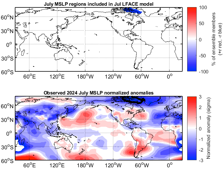
Another predictor in WeatherTiger’s U.S. landfall risk model is summer sea-level pressures in the Canadian Arctic, which were below normal in July. This can be a tell favoring a stronger peak season Bermuda-Azores High, which may keep Atlantic hurricanes moving westward in the general direction of the continental U.S. longer than they would otherwise. Still, all these relationships are fairly weak, as the jet stream patterns that steer hurricanes are chaotic and defy efforts to be reliably predicted more than about 10 days ahead of time.
With about a quarter of the season in U.S. landfall terms behind us, Beryl and Debby have unleashed about as much storm energy near the continental U.S. as an average year since 1900. WeatherTiger’s landfall risk model projects one to two times that amount of landfall activity again, or a 75% chance of at least two more U.S. hurricane landfalls in 2024. This is also about 55% odds of at least one Cat 3+ U.S. landfall, against an average chance of 35% after August 20. (Supporters, you can find specific odds and predictions for Florida’s hurricane landfall risks behind the paywall below.)
In short, expect plentiful Atlantic hurricane activity in the next two months. Much of that activity, as usual, will be directed into the open Atlantic. Probably not all of it will be. Florida and Texas each have one conepanic under their belts in 2024, and given the possibility of an intermittent risky steering current regime in late August, September, and October, expect more conepanic(s) to come.
If I could push a button and make that reality go away, I would; in fact, I tried that, and the Atlantic seems to have taken it personally. There’s no easy way out of a hurricane season like this one, only through it with preparation, luck, and an even keel. We can’t reset the Atlantic, so reset yourself by using the quiet of the next week or two to physically and mentally prepare for the peak season Big Dogs to follow, and keep watching the skies.
Florida landfall risks forecast (supporter exclusive)
Keep reading with a 7-day free trial
Subscribe to WeatherTiger's Hurricane Watch to keep reading this post and get 7 days of free access to the full post archives.

