The Floridaman's Guide to Hurricane Season: Hurricane Watch Weekly Column for July 27th
A whirlwind tour of Florida's hurricane history, region by region.
If you are not already a supporter, please consider signing up for a paid subscription to WeatherTiger’s Hurricane Watch. You’ll get Florida-focused tropical briefings each weekday, plus weekly columns, coverage of every U.S. hurricane threat, our exclusive real-time seasonal forecast model, and the ability to comment and ask questions, for $7.99/mo. or $49.99/yr.
I, the WeatherTiger, am a Floridaman. This must be distinctly understood, or nothing can come of the hurricane history I am going to relate.
While I have never dialed 911 because a Taco Bell line was moving too slowly or been attacked by a trunkful of thawed iguanas, I am a third-generation Floridian with a record of zany antics, such as trying out for the U.S. national team handball program despite having zero experience with, or understanding of, team handball. I also forecast hurricanes for a living. It doesn’t get much more Florida than that.
Like all Floridamen, I know that Florida contains the multitudes. This is true of the wild variance in the meaning of “barbeque” between the northwestern and southeastern corners of Florida. It is also true of hurricane season, with unique fingerprints to tropical risks between various parts of the state.
With no tropical activity in the Atlantic and none on the horizon for the next 10 days, let’s take a regional look at Florida hurricane climatology. While hurricane season is one-third complete on the calendar, unfortunately it is only around 10% done in Florida landfall activity terms, and much less than that for some. I’ll examine when Central Florida, Southwest Florida, Southeast Florida, and the Panhandle experience peak hurricane risks, and from whence those threats arise.
Methodological note: I define the Panhandle as west of Lake City, Central Florida as east of Lake City and north a Bradenton-Vero Beach line, and Southeast and Southwest Florida as south of that line and east and west of Lake Okeechobee, respectively. As storms have no respect for lines on a map, counts reflect that one hurricane may impact multiple regions.
The Panhandle
Depending on the source, the National Magnet Lab in Tallahassee either attracts hurricanes, keeps them away, or emits 5G signals heralding a third non-consecutive term for Grover Cleveland. While the truth remains out there, it is a fact that the Panhandle gets off to the fastest start of any part of the state, as “Steinhatchee Season” delivers a pipeline of mostly weak but wet tropical storms to the Big Bend in June. Early hurricane landfalls, like 2005’s Category 3 Dennis, are possible in the first third of the season as well, mostly originating in the Caribbean; 9 of the 53 Panhandle hurricane strikes since 1851 have occurred prior to August (17%).
The August and September peak months of hurricane season see 58% of historical hits, split between direct landfalls out of the Gulf and Caribbean, like Hermine, and storms that continued into North Florida after initially striking Florida’s East Coast, like 1995’s Erin. The final 13 historical hits (25%) come in October and November—most, like Michael, in the first half of October, with a steep drop-off in Panhandle landfall rates thereafter as the action shifts south.
Central Florida
Central Florida’s hurricane history reflects the broader identity crisis of the region, haphazardly mixing the tropical flavor of South Florida’s climatology with the “Boiled K-jun P-nuts” oeuvre of the northern Gulf Coast. Hurricane season gets off to a slower start here, with three historical landfalls in June and July. Central Florida’s risks are the mostly sharply focused of any region on the peak season, with 25 of 40 (62%) of historical strikes occurring in August and September. Most of these storms are Southeast Florida landfalls that continued northwest into Central Florida, like 2004’s Frances and Jeanne, while a comparative few are landfalls on the northeast Florida coast like 1964’s Dora.
The final 30% of activity occurs after September, divided between Southwest Florida landfalls moving inland, and direct hits like 1921’s Category 3 Tampa Bay hurricane, a storm that keeps hurricane climatologists awake at night as a very dangerous scenario if repeated.
Southwest Florida
The final redoubt of the Florida panther, the Bubble Room, and the skunkape, North America’s southernmost native Sasquatch, Southwest Florida has a seasonal distribution of hurricane risks all its own. June and July are quiet, with only one landfall since 1851, and August and September bring around half of all hurricane strikes. The majority of those storms make initial landfall in Southeast Florida and continue west, with a handful like 2004’s Charley looping north out of the Caribbean.
After a late September lull, mid-October brings the highest frequency of direct landfalls to Southwest Florida, with 19 cases representing almost half of all historical hurricane strikes. Category 3 Wilma in 2005 is a classic example of this archetype, developing in the western Caribbean before launching northeast across South Florida.
Southeast Florida and the Keys
Will Smith describes the climate of Southeast Florida as “five-hundred degrees in the Caribbean seas” where “the rainstorms ain’t nothin’ to mess with,” later adding “haha, na na na, woo!” While Mr. Smith’s assessment of average summer high temperature misses the mark by around 407°F (193 Kelvin), he is correct that Southeast Florida has a different Köppen climate zone classification than the rest of the state—mostly tropical monsoon, rather than humid subtropical.
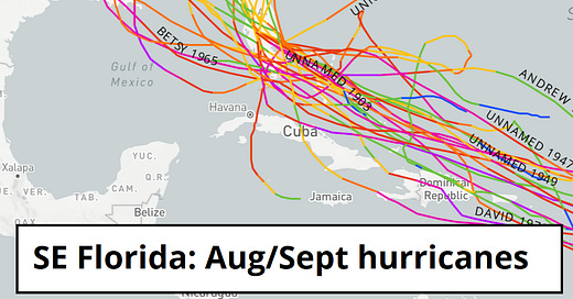
This distinction influences Southeast Florida’s substantial hurricane risk profile, with direct landfalls usually originating from tropical waves out of the eastern Atlantic’s Main Development Region. June and July, before the African wave train cranks up, have only two hurricane landfalls to their account. Twenty-six landfalls, including devastating hurricanes in 1926, 1928, 1935, 1945, plus 1992’s Andrew and 2017’s Irma, slot into the August and September peak months of the season and account for most historical direct landfalls. Another 20 hurricanes, about 40% of the total, occur after September, and are a mix of Southwest Florida landfalls racing northeast and Caribbean-originating direct hits on the Keys.
In summary, history shows that Florida’s hurricane season has barely begun, and for some will not peak for another two and a half months. To conclude our whirlwind tour in true Florida style, please gather your personal belongings and exit through the gift shop, where you can purchase supplies to complete your hurricane disaster kit, as well as 1,000 varieties of beef and reptile jerky, plus K-jun P-nuts. Keep watching the skies.
Next update: Our regular daily briefing will resume tomorrow for paid subscribers.


Agree with Brenda. We, who are smitten with the weatherfeline extraordinaire, kindly submit a request for gear, which will be worn proudly at sporting events, festivals, colonoscopies and births of newborn calves.
A native of Florida and a history buff enjoyed and was educated by the July 27 edition. Born in Moore Haven, Glades County, Southwest shores of the feared Lake Okeechobee which was calmed by the building of the pike following the devastating hurricane that brought the lake over the town of Moore Haven. Hurricanes still bring a certain uneasiness to this Glades County guy!