WeatherTiger's Hurricane Ian Forecast Analysis for September 26th (PM)
Ian is gathering strength as it sets a course for the eastern Gulf; slow movement will mean prolonged, significant impacts for much of Florida.
This post may be freely shared. WeatherTiger’s afternoon analysis will go out daily at around 3:30 p.m. to both paid and free subscribers. A morning briefing covering key overnight developments and forecast changes started today for paid subscribers only and will continue for the duration of Ian’s threat.
Please consider a paid subscription to support the Hurricane Watch and get all of our round-the-clock coverage of Ian.
Watch our evening live video update here: https://www.facebook.com/weathertiger/videos/1419395898554834/
Hurricane Ian is fast becoming the powerful storm it was long predicted to be over the scalding waters of the western Caribbean. While the range of landfall possibilities remains broad due to Ian’s shallow angle of approach to Florida’s Gulf Coast, it is increasingly certain that the state will see widespread surge, wave, and rain impacts no matter the specific outcome.
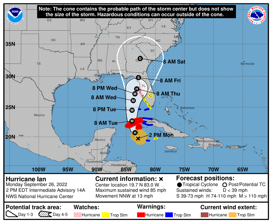
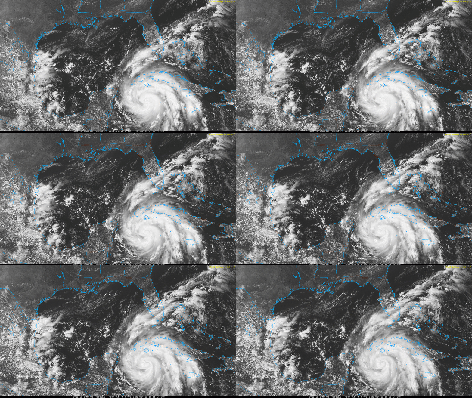
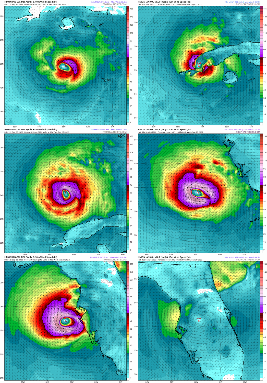
As of the NHC’s 2 p.m. advisory, the center of Hurricane Ian is located about 550 miles due south of Tampa Bay, moving north-northwest at about 15 mph. Maximum sustained winds have increased to around 85 mph and are rising. Intense core convection indicates that the rapid intensification cycle is proceeding apace, and there is no change to the expectation that Ian will be a Category 4 hurricane in the southeast Gulf of Mexico by Tuesday evening.
Ian’s movement on Monday is closely following the last several NHC forecast tracks, perhaps just ever so slightly faster than projected. The NHC forecast has not changed much in the last few advisories after nudging east yesterday; currently, the NHC track lies about 50 miles southwest of Tampa Bay on Wednesday night, with the 3-day cone of uncertainty covering much of Florida from western Apalachee Bay to the Fort Myers area.
This cone is designed to roughly show the area that the center of a tropical system will stay within about two-thirds of the time, not the extent of impacts. Destructive surge, rain, and wind impacts occur well beyond the strictures of the cone, and that will be the case with Ian.
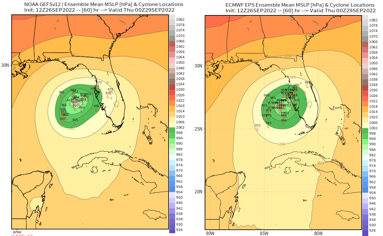
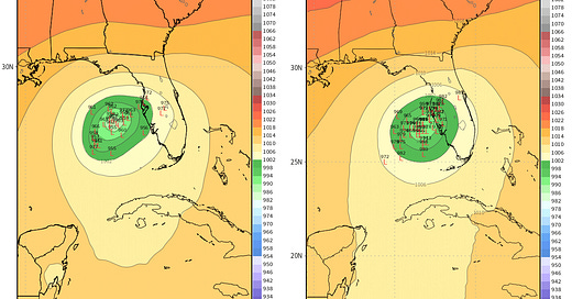
Sorting out where and when those impacts will occur along the Gulf Coast remains a major challenge. While modeling has come into better agreement since Sunday, with the American GFS model swinging east and the European model edging west to converge on the NHC track forecast, their consensus is an unusual, twisting path near or just offshore Florida’s West Coast.
Basically, the U.S. East Coast trough that will turn Ian north and north-northeast over the eastern Gulf on Tuesday and Wednesday is now likely to move away on Thursday without accelerating Ian to the northeast. As Gulf steering currents subsequently weaken, Ian will probably trace a slow, erratic path north or north-northwest on Thursday and Friday.
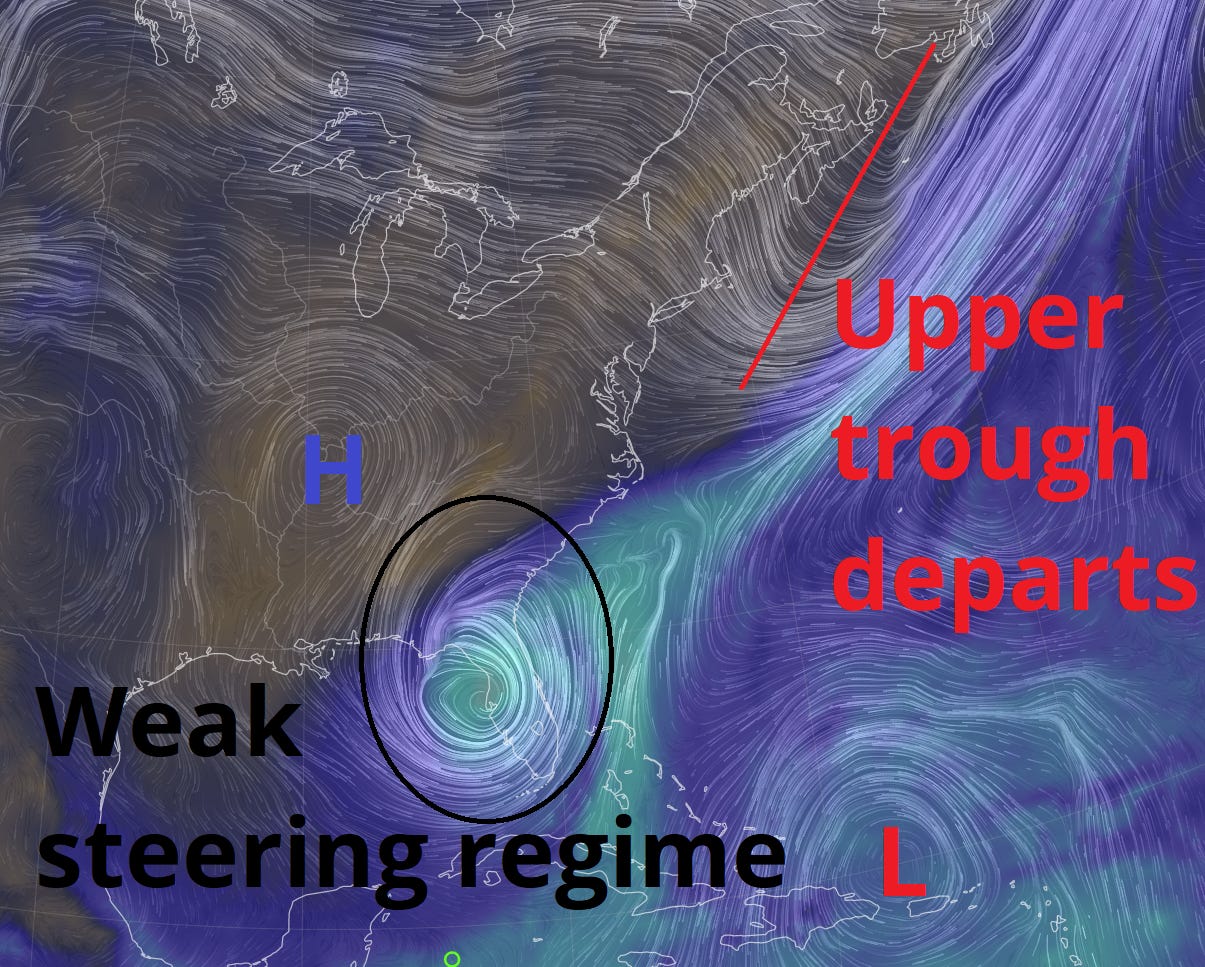
NHC forecasts and model guidance are in consensus on this general scenario. However, what we don’t know is whether this deceleration and turn will occur onshore or offshore, i.e., before or after landfall. The average NHC forecast error for two-and-a-half day forecasts is about 80 miles: therefore, a forecast of a Category 3 hurricane within 50 miles of Tampa Bay on Wednesday night could mean a direct hit there, or a track over 100 miles offshore. With very subtle differences in storm structure and steering making the difference, even the world’s-best forecasters at the NHC simply don’t know which of those will occur. And neither do I.
Given that we know that we still don’t know, today I’m going to discuss what the general impacts of the onshore, near shore, and farther offshore track scenarios might be for Florida as a whole.
Ian reaches shore in the Tampa area or south (30% chance)
If Ian moves just a little faster than currently predicted or the troughing is just a bit deeper or more persistent than the consensus, a slightly sharper turn to the northeast could bring Ian onshore in the Tampa Bay region or even south before its momentum slows. In this case, the upper-level environment will probably allow Ian’s maximum winds to plateau on approach rather than weaken significantly, so a Wednesday landfall likely would be at or near major hurricane intensity.
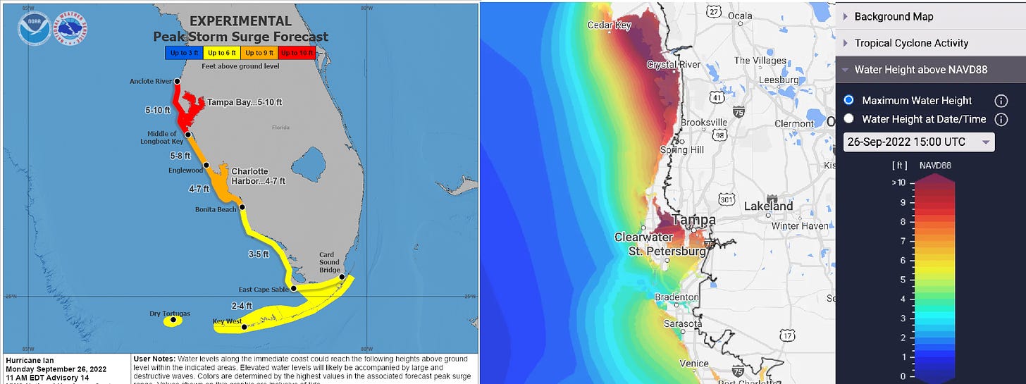
With Ian tracking closer to Southwest Florida as a major hurricane, this scenario would mean catastrophic storm surge and wave impacts from Tampa Bay into Southwest Florida. (A Storm Surge Watch is already in effect from Tampa into the Keys.) Given the shallow waters of the coastal shelf and the cul-de-sac shape of Tampa Bay, a major hurricane crossing over or just offshore of Tampa would cause inundation of heavily populated, low-lying areas, as well as severe wind damage. If you receive an evacuation order, do not delude yourself into staying because you’ve “seen this before.” It has been over 100 years since a major hurricane directly impacted Tampa Bay. You haven’t seen this before.
After landfall, Ian would probably move slowly north inland over west and north Central Florida, possibly for a couple of days. This may cause inland flash flooding from Central Florida to the Big Bend and northeast Florida. This scenario means lighter impacts for the Panhandle.
Offshore scrape, then Nature Coast or Big Bend (35% chance)
This scenario is what the NHC forecast currently shows: no landfall in Tampa, but an exceedingly close scrape of the Tampa Bay area and Nature Coast Wednesday night and Thursday, with a path north into the Big Bend by late Thursday or Friday.
In this scenario, the net wind impacts on the Florida coast might be lower overall, assuming the eastern eyewall remains offshore the Bay area as the slow grind north begins. By Thursday, wind shear and dry air will team up to bring down Ian’s maximum winds, though a broadening of the windfield would still mean coastal wind damage in the Big Bend and Nature Coast, both of which would see more surge in areas east of the center’s track in this scenario than with an earlier landfall to the south.
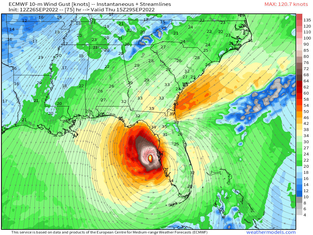
If Ian is passing around 50 miles (or fewer) west of Tampa Bay late Wednesday and Thursday, storm surge and wave activity will still likely cause extreme flooding in the Tampa metro area, far worse than that seen during Tropical Storm Eta in 2020, and perhaps nearly as extreme as scenario 1 depending on how quickly Ian moves away. Surge impacts into Southwest Florida could still be quite destructive as well, and inland flood potential from excessive rains would remain significant from the eastern Panhandle south to North Central Florida through Friday or Saturday.
Further west in Gulf, then north to Panhandle (35% chance)
Finally, a slower, more westward-moving Ian or weaker trough may allow the hurricane to remain 100 miles or more west of Tampa mid-week, before drifting north towards the Florida Panhandle on Friday or early Saturday. This would be the best outcome, all things considered, though not for Panhandle residents. Surge and wave impacts in Tampa Bay and Southwest Florida will likely still be considerable even with a track farther offshore, and Apalachee Bay and the Big Bend would see a massive surge due to a long southerly fetch of winds. Intermittent heavy rainfall causing localized flooding between at least Wednesday and Friday would be a key threat to inland West-Central and North Florida.
The longer Ian stays offshore, the more its wind impacts will likely be diminished. If Ian makes landfall on Wednesday, it’s probably as a healthy hurricane; if it makes landfall on Thursday, it’s probably as a hurricane in distress; if it makes landfall on Friday (or after), it might not look much like a hurricane at all. Of course, hurricanes don’t need to look like a classic hurricane to cause widespread damage, destruction, and misery, and even this scenario would have widespread impacts on Florida.
No doubt Ian has plot twists in store, as a hurricane moving slowly parallel to a coastline is a recipe for major shifts in the location and severity of impacts. The key takeaway from these general scenarios is that everyone in the eastern Panhandle, Big Bend, west Central Florida, Tampa Bay, and Southwest Florida regions should be ready to put your hurricane plans into place if called upon to do so. Keep watching the skies.



![[Image of WPC Flash Flooding/Excessive Rainfall Outlook] [Image of WPC Flash Flooding/Excessive Rainfall Outlook]](https://substackcdn.com/image/fetch/w_1456,c_limit,f_auto,q_auto:good,fl_lossy/https%3A%2F%2Fbucketeer-e05bbc84-baa3-437e-9518-adb32be77984.s3.amazonaws.com%2Fpublic%2Fimages%2F81fdde4d-8f0e-489a-9e6b-d1e1fa30a191_1090x692.gif)

I'm a paid subscriber, but thanks for making these free so I can share with a couple of friends and family that don't subscribe.