Hot Gulf Rain Machine: Hurricane Watch Weekly Column for June 12th
Heavy rainfall continues in Florida through Friday, as the odds of the first named storm developing in the upcoming week tick upward. But what's in a name?
WeatherTiger’s Hurricane Watch is a reader-supported publication. Paid subscribers get Florida-focused daily tropical briefings, plus weekly columns, full coverage of every hurricane threat, our exclusive real-time seasonal forecast model, and the ability to comment and ask questions for $49.99 per year.
Broadly defining summer as Easter to Halloween, there are three kinds of summer weather in Florida: hot and wet, hotter and dry, and a third kind that shall not be named. This week, depending on where you stand along the Gulf Coast, all three options are in play, though that dreaded third kind is likely to make only a peripheral appearance— at least in name.

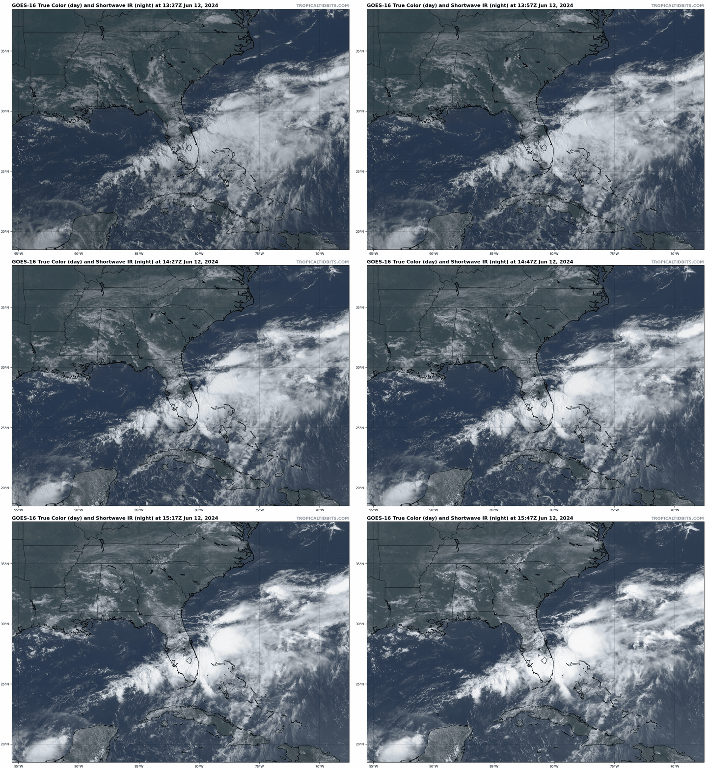
Florida’s current weather is a study in this contrast. While North Florida bakes under a McDonald’s fry lamp sun, Central and South Florida are seeing soaking rainfall and scattered flash flooding courtesy of a tropical disturbance (Invest 90L) extending from the eastern Gulf of Mexico into the Southwest Atlantic. While 90L will not become a named tropical storm before clearing Florida, local impacts will continue to be significant, particularly in Southwest Florida. If I was Malcolm Gladwell, I might say something sticky like “rain without a name, impacts stay the same.”
The issue is that periodic deep convection has been developing for several days to the east of the disturbance’s weak low-level circulation, which has meandered from the southeastern Gulf into Florida today. Wind shear is displacing this convection away from the low’s center and preventing tropical development, but divergent upper-level winds are favorable for rising motion in the atmosphere.
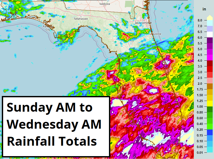
Couple that with deep Caribbean moisture and record Gulf water temps already in the mid-80s, and you have a recipe for disorganized but drenching storm clusters. As of mid-day Wednesday, rainfall totals south of Orlando are mostly in the 1-3” range, a beneficial antidote to ongoing severe drought. However, excessive rainfall of 3-6” or more has fallen across the southern tip of Florida, triggering intermittent Flood Warnings in Metro South Florida. The Sarasota area saw around 6" of rain in just a few hours on Tuesday evening, causing serious flood problems.
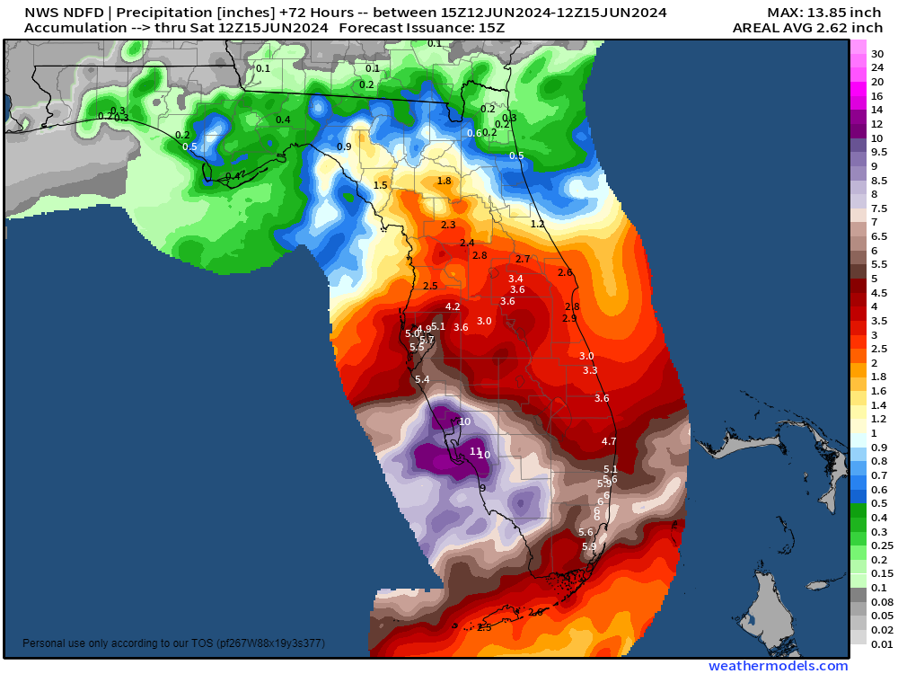
With several additional rounds of heavy rainfall likely through early Friday, more localized street and river flooding are a good bet, especially where soils are already saturated. Coastal Southwest Florida and urban Southeast Florida are at the greatest risk of another 3-6”+, but everyone in south-central and South Florida should be monitoring local National Weather Service forecasts for up-to-date Flood and Flash Flood Warnings. As Malcolm Gladwell would say, “turn around, don’t drown.”
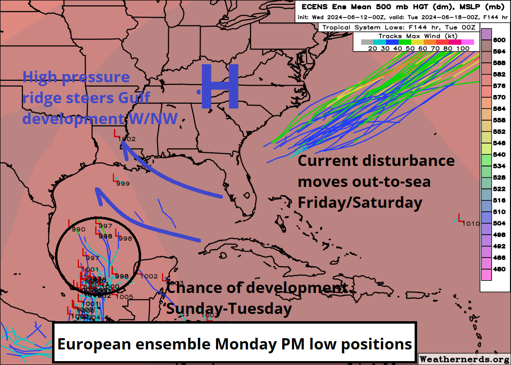
Rain coverage in Florida should decline on Friday as the area of low pressure moves away from the Southeast. As it accelerates out-to-sea, apparent wind shear will diminish, and a thermodynamic boost from the Gulf Stream might help the low snag the name Alberto. However, even if it does become the first named storm of 2024, there will be no further impacts on land.
This tropical troublemaker will thus join the list of unheralded systems to have its greatest impacts before receiving a name or never to be classified at all, like last November’s unnamed storm in South Florida, the precursor to Alex in June 2022, or the deadly Louisiana floods of August 2016. While each of these systems failed to meet the formal criteria to become a depression or storm, there’s not a lot separating them from messy June storms like 2012’s Debby, 2020’s Cristobal, or 2021’s Claudette.
In all these cases, flooding rainfall displaced from a loose circulation center—sometimes by several hundred miles—was the primary impact. These systems don’t necessarily conform to common ideas of what a tropical cyclone “should” look like, which remains tethered to windspeed by legacy metrics like hurricane categories and name thresholds. This can unfortunately mean that risks from flash and river flooding are perceived as lower than they are. If you don’t think there’s drawbacks to categorizing and anthropomorphizing the natural world, just ask Grizzly Man.
In fact, while storm surge is the leading historical cause of death from hurricanes, since 2013 over half of the direct fatalities from tropical cyclones have been due to freshwater flooding, with wind accounting for just 10% of deaths in the past 60 years1. This gap would likely expand further with the inclusion of flash and river floods caused by unnamed disturbances, and shows that rainfall is every bit the tropical threat that storm surge and wind are, if not an even greater one due to the lower predictability of localized impacts.
This lesson is also applicable to the other chance of tropical development this week. Low pressure over the far southwestern Gulf of Mexico will move little over the next few days, and will combine over the weekend with another disturbance pirouetting around a broad gyre over Central America. This combo has a decent shot at becoming a tropical storm over the western or southern Gulf early next week and could strengthen further before reaching land if it has time to do so, as upper-level outflow appears conducive for development. High pressure over the Deep South should steer whatever forms west or northwest, away from Florida and towards Mexico or Texas. These areas should at the very least expect heavy rainfall potential, and perhaps more.
In short, for those in South Florida this week and the western Gulf Coast next week, be mindful of the contrarian fact that rain without a name can be just as impactful as rain with a name, and that perhaps the first and third kinds of summer weather aren’t so different under certain circumstances. For the rest of us, slather on that UV-A and UV-B protection, and keep watching the skies.
While this seems counterintuitive, in the words of Malcolm Gladwell, "Between David and Goliath, which one would you say is David, and which is Goliath? If you're like 81% of Americans, you'd say David is David, and Goliath is Goliath. But you'd be wrong. It turns out Goliath is David, and David is actually Goliath."


