Tropical Storm Ian Situation Briefing: September 29th
Ian is moving offshore the Space Coast this morning. Impacts will continue in Northeast Florida into early Friday.
This is the final Florida threat discussion for Ian. Previous forecasts may be found at these links:
Threat discussion for September 19th
Threat discussion for September 20th
Long-form threat discussion column for September 21st
Threat discussion for September 22nd
Tropical Depression 9 Forecast Analysis for September 23rd
Tropical Storm Ian Forecast Analysis for September 24th
Tropical Storm Ian Forecast Analysis for September 25th
Hurricane Ian Morning Briefing for September 26th
Hurricane Ian Forecast Analysis for September 26th (PM)
Hurricane Ian Morning Briefing for September 27th
Hurricane Ian Florida Impacts Forecast for September 27th
Hurricane Ian Morning Briefing for September 28th
Hurricane Ian Landfall Live Blog (9/28, Noon-6:30 p.m.)
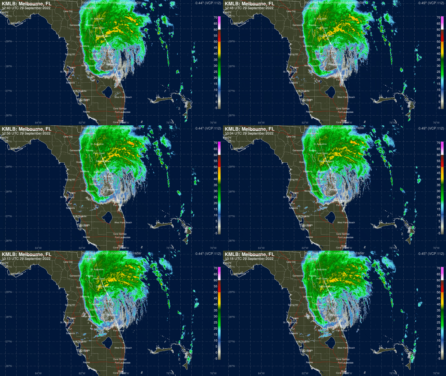
As of Thursday morning, Ian has weakened to a tropical storm and exited Florida’s East Coast, leaving a trail of flooding rainfall and inland power outages in the wake of its peninsular trek. Significant wind, surge, and rain impacts will continue through Thursday for Central Florida and North Florida, and Ian will reach into the Carolinas Friday and Saturday.
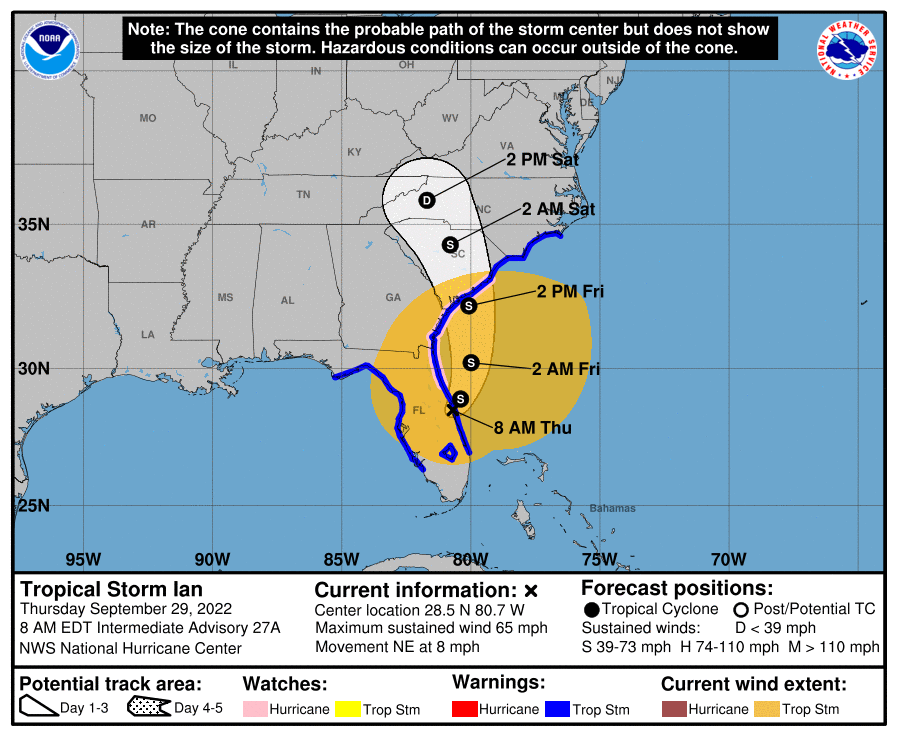
As of the intermediate advisory issued by the NHC at 8 a.m., Tropical Storm Ian is located about 40 miles east of Orlando and very close to Cape Canaveral, moving northeast at about 8 mph. Ian moved a little more eastward than forecast after landfall, thus reaching the Atlantic Coast faster than anticipated, and will be back over water through Friday afternoon.
Maximum sustained winds per this advisory are down to 65 mph, primarily in offshore bands north and east of the center. With the overnight weakening of Ian’s core, the storm’s windfield has spread out, and tropical-storm-force winds now extend up to around 300 miles northeast of the center of circulation.
Ian will move north-northeast and then north through Friday, likely curling back inland over South Carolina on Friday afternoon. With Ian’s vertical structure in tatters due to land interaction and shear, maximum sustained winds are unlikely to climb much prior to Ian’s second U.S. landfall. Re-attaining minimal Category 1 strength is possible, though remaining a strong (and expansive) tropical storm is more likely.
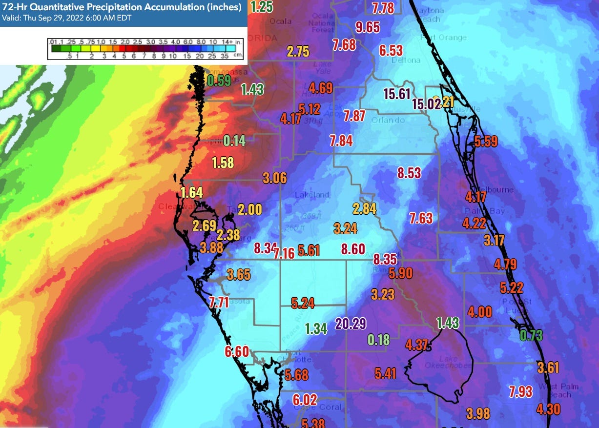
Ian’s impacts will gradually clear Florida from south to north between Thursday morning and early Friday. Through 9 a.m. Thursday, rainfall totals along the I-4 corridor are anywhere from 6” to 20”, and major flash flooding issues are occurring in east Central Florida this morning. Expect another 3-6” from Orlando north to Jacksonville during the day on Thursday, heaviest along the east Central Florida and Northeast Florida coasts. Very dry air is filtering into Florida behind Ian, and no further precipitation is expected across the state for at least 5-7 days after the storm clears. Rainfall totals across the Carolinas and southern mid-Atlantic will be generally 3-6” between Friday and Sunday.
Due to the inner core of Ian degrading overnight, top wind gusts in east Central Florida are in the 60-70 mph range as of Thursday morning. Tropical-storm-force winds with hurricane-force gusts along the coast will continue north of Cape Canaveral to the Jacksonville area and coastal Georgia before winding down early on Friday. A broad area of tropical-storm-force sustained winds and potential hurricane-force gusts is likely along the Carolina coast from Friday morning into early Saturday. Tropical-storm-force gusts will be felt well inland in the Carolinas into Saturday morning.
Surge impacts in northeast Florida and coastal Georgia remain a key concern on Thursday, and the NHC is still calling for 4-6’ peak surge there and 3-5’ along the northern Saint Johns River. Peak surge is likely in these areas late Thursday, as Ian’s move back offshore and arcs toward South Carolina will direct a strong onshore flow of tropical-storm-force winds towards Northeast Florida, including the Jacksonville area. The tornado threat from Ian from Thursday into Saturday for northeast Florida and the Carolinas is minimal.
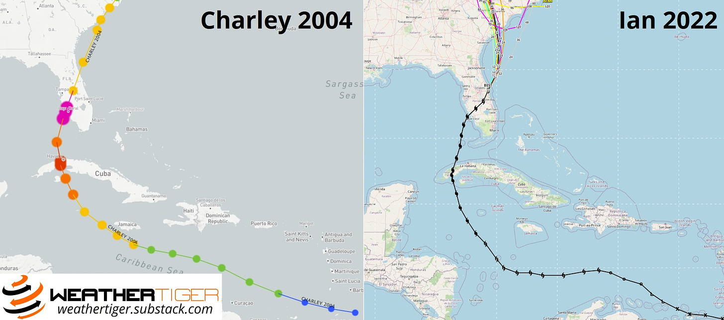
In short, serious and significant impacts are continuing in Florida through Thursday, but should end in the state and be replaced by fair weather for recovery efforts by Friday. Unfortunately, Ian has met or exceeded all or most of the forecast benchmarks of wind, surge, rainfall impacts laid out prior to landfall. While Hurricanes Ian and Charley share a landfall point, maximum wind speed, and pressure, Ian’s larger size and slower movement elevate its surge and rainfall impacts well beyond Charley, both in absolute maximum terms and geographical scope of impacts. Conversely, Ian’s maximum winds across east Central Florida were thankfully lower than Charley’s.
Stay safe today as Florida rides out the back side of one of the very worst hurricane disasters, if not the absolute worst, in our state’s history— time will tell. Keep watching the skies.


![[Image of WPC QPF U.S. rainfall potential] [Image of WPC QPF U.S. rainfall potential]](https://substackcdn.com/image/fetch/w_1456,c_limit,f_auto,q_auto:good,fl_lossy/https%3A%2F%2Fbucketeer-e05bbc84-baa3-437e-9518-adb32be77984.s3.amazonaws.com%2Fpublic%2Fimages%2F5769f942-76cf-4c9a-b418-0af84ac9e17c_892x716.gif)
![[Image of cumulative wind history] [Image of cumulative wind history]](https://substackcdn.com/image/fetch/w_1456,c_limit,f_auto,q_auto:good,fl_progressive:steep/https%3A%2F%2Fbucketeer-e05bbc84-baa3-437e-9518-adb32be77984.s3.amazonaws.com%2Fpublic%2Fimages%2Fae7e3a05-03e4-4ec2-b0b0-95d26057bd72_897x736.png)

Jon, Susan, you are so right! Dr. Ryan’s masterful and concise presentations of alternative Ian path scenarios was a cut above any alternative source…..one of the many reasons I will continue to subscribe!
Thanks so much for your "usual" forecasts that are always "right on the money"!!!!!!!!!!!!!!!!!!!