


Fully Invested: The Hurricane Watch for September 22nd
Invest 98L gets better organized and is a significant threat to Florida next week. The Atlantic is also full of other invests, plus Cat 4 Fiona and Gaston.

If you are not already a supporter, please consider signing up for a free or paid subscription to WeatherTiger’s Hurricane Watch. Paid subscribers get Florida-focused tropical briefings each weekday, plus weekly columns, coverage of every U.S. hurricane threat, our exclusive real-time seasonal forecast model, and the ability to comment and ask questions, for $7.99/mo. or $49.99/yr. Free subscribers receive our weekly columns and storm coverage in your inbox.
Florida tropical threat synopsis: Invest 98L is a significant threat to Florida in 5-8 days. It is too early to distinguish whether the Panhandle or Florida peninsula is more at risk at this time— all Florida residents should be watching carefully.
Almanac: It’s Thursday, September 22nd… day 114 of the 2022 hurricane season, 69 days to go. By total storm energy, the season is 66.8%, 75.6%, and 66.8% complete for the Atlantic, continental U.S., and Florida, respectively.
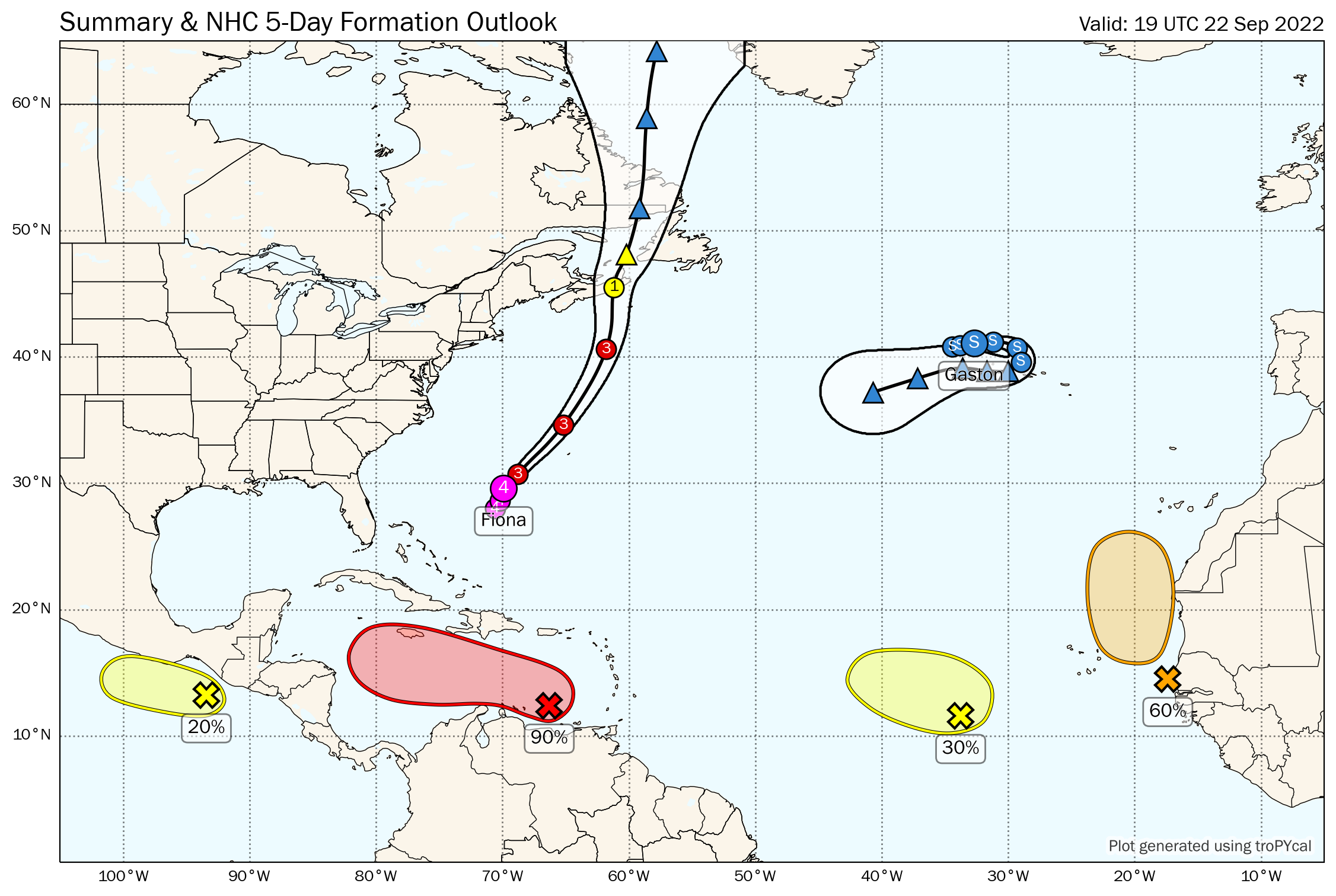
Active Storms:
Hurricane Fiona: Fiona is still a Category 4 hurricane this afternoon, with 130 mph sustained winds. The hurricane will pass well west of Bermuda early tomorrow, but likely still bring hurricane-force wind gusts to the island due to its expansive windfield. As Fiona merges with an upper-level low over Atlantic Canada this weekend, an exceptionally strong non-tropical low will result, causing widespread wind and surge damage in Nova Scotia and Newfoundland, and possibly breaking the record for lowest pressure ever recorded in Canada.
Tropical Storm Gaston: Gaston is hanging tough northwest of the Azores with 65 mph winds. The storm will swipe the western Azores tomorrow before looping back to the west over the weekend, likely weakening and potentially dissipating as it does. Still not a concern.

Other Disturbances in NHC outlook, with 2-/5-day NHC development odds:
Invest 98L east of the Lesser Antilles (80/90%): The tropical wave currently crossing the eastern Caribbean, the notorious Invest 98L, is still not a tropical depression or tropical storm. However, there have been some key structural changes today that signal development is not too far in the future, setting up what continues to look like a dangerous situation for the Florida peninsula and/or eastern Gulf Coast next week.

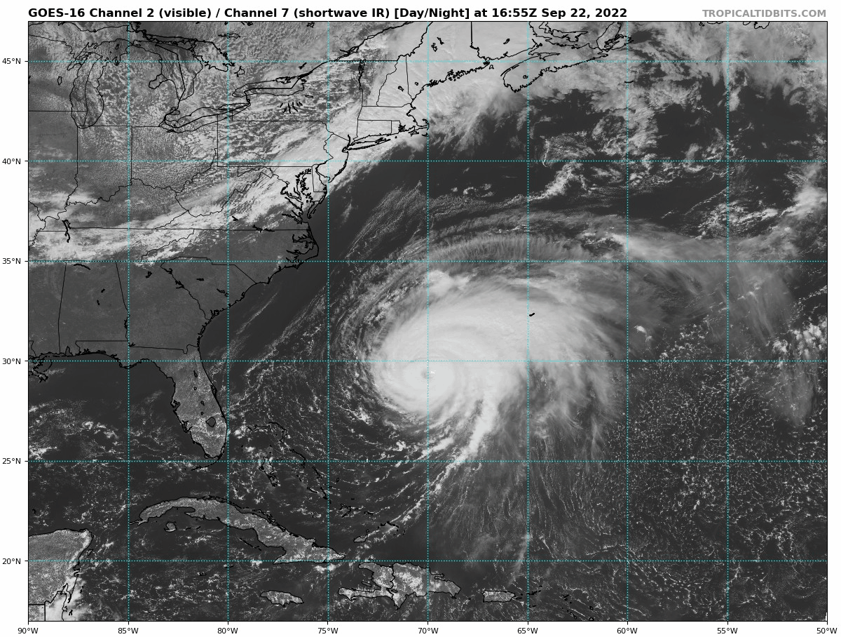
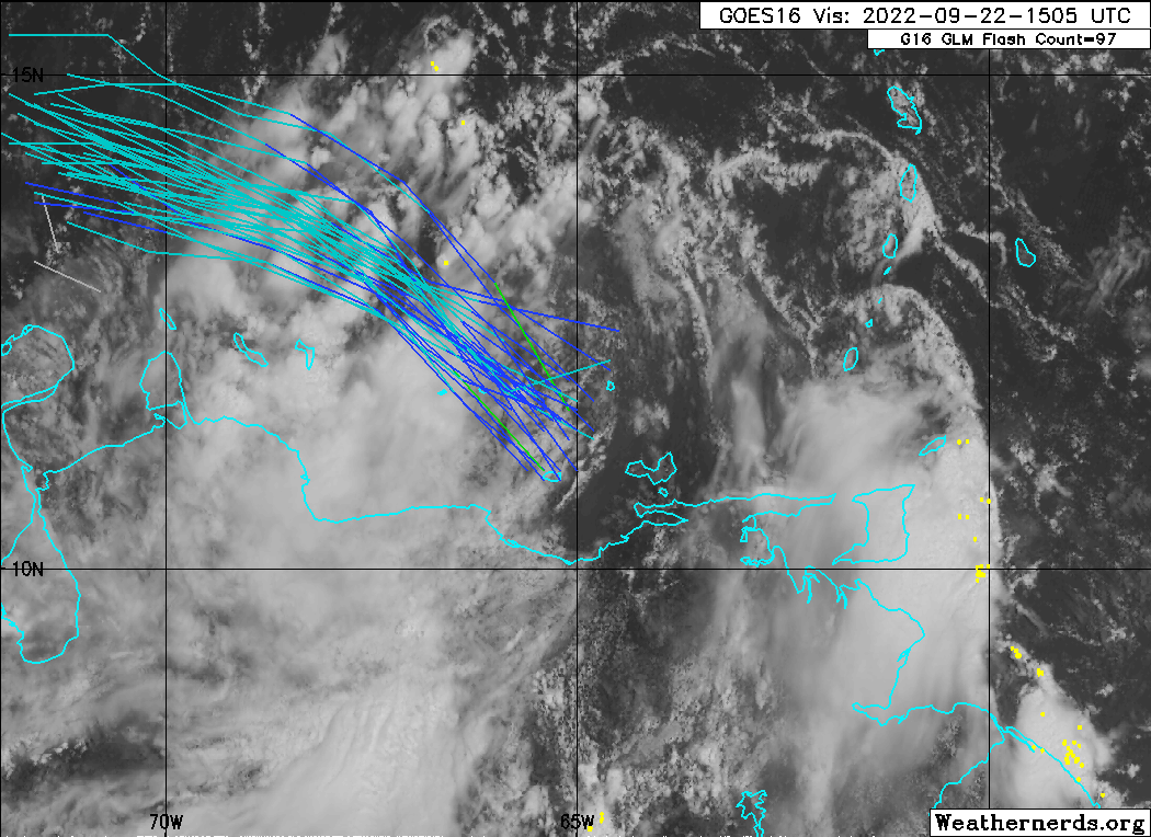
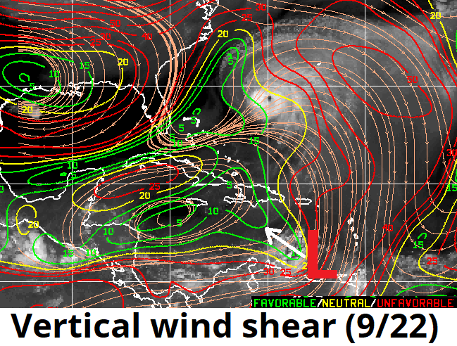
As shown on visible satellite imagery, 98L has lifted north off the Venezuelan coast this afternoon, with a broad but closed surface circulation taking shape in the midst of where ensemble guidance suggested it would today. While 98L remains in a marginal environment for immediate intensification, as shown below it will be moving into a notably lower shear environment over the next 24 hours. As shown below, getting out from under the 25 knots of northerly shear associated with Fiona's outflow should allow 98L to start generating more convection near its broad center, and a tropical depression is likely to develop in the central Caribbean the next 24-48 hours.

There is no change to the expectation of a favorable environment for further strengthening, potentially rapid, late in the weekend as 98L crosses the western Caribbean Sunday and Monday. Nor is there a major change in the general steering regime, with a turn northwest and north expected by early next week due to a trough over the eastern U.S. If trends toward organization continue, a possibly formidable 98L will enter the Straits of Florida or Gulf of Mexico on Tuesday or Wednesday.
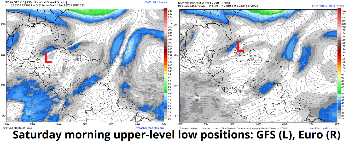
The positioning of an upper low on Saturday make be a key to 98L’s track. There remains considerable uncertainty in how far north 98L will get in the central and western Caribbean over the next four days. Some of this is still associated with how quickly 98L develops and is structured; with a nascent center consolidating, that source of uncertainty may well diminish in the modeling soon. The rest appears to be how 98L will interact with a small upper-level low over Cuba early in the weekend. The Euro and Canadian models are slower to move this upper low out of the way and thus pivot 98L more northwest on Saturday, while the GFS and UKMET move the upper low westward more quickly and show 98L’s track continuing west-northwest through the weekend.
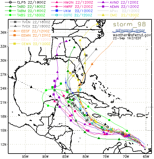
This matters quite a bit, because a more northward weekend track is more of a threat to the Florida peninsula next week, while a more westward track through model puts Panhandle or central Gulf Coast at higher risk. There’s no easy way to differentiate these scenarios today, as neither the GFS nor Euro model appear obviously wrong in how they are handling this subtle upper low. Overall, the small organizational steps forward 98L has taken today increase the chances of a hurricane entering the Straits of Florida or eastern Gulf by the middle of next week, but too much uncertainty remains to say much more than that at this time. Stay tuned.
Invest 99L, central MDR (20/30%): Invest 99L is also out there halfway between Africa and the Lesser Antilles. Weak steering currents mean only slow and generally northward movement for the next 3-5 days. Slow development is possible, but 99L is not a threat to land.
Invest 90L over West Africa (60/60%): This wave just emerging from Senegal is coming off the coast nearly at tropical depression strength. It may well peak as a modest tropical storm in 1-2 days before its unusual northward path takes it into colder waters. A rival with 98L for claiming the name Hermine and nothing else.


Elsewhere: No.
Next report: Daily update tomorrow afternoon.