


WeatherTiger's Tropical Storm Ian Forecast Analysis for September 25th
Models continue to disagree on Ian's forecast path to Florida. Will the east or west track win out and why?

This post may be freely shared. An afternoon forecast discussion will go out tomorrow and through Ian’s threat to both paid and free subscribers. An additional morning briefing covering overnight developments and forecast changes will begin Monday morning for paid subscribers only.
Please consider a paid subscription to support the Hurricane Watch and get all of our round-the-clock coverage of Ian.
Tropical Storm Ian is churning northwest across the Caribbean, poised to launch a run of rapid intensification expected to elevate it to Category 4 intensity in the eastern Gulf by Tuesday.
Yet even as Ian is one day closer to Florida today, a significant spread remains in potential outcomes, and everyone from Southwest Florida into the Panhandle should prepare for the possibility of a hurricane hit.

As of the 2 p.m. Sunday intermediate advisory from the National Hurricane Center, Ian’s maximum sustained winds are around 50 mph. The storm is beginning its gradual bend to the north, and its west-northwest heading at 10-15 mph will turn more northwest and then north-northwest into Monday. On this track, Ian should cross over far western Cuba early on Tuesday.
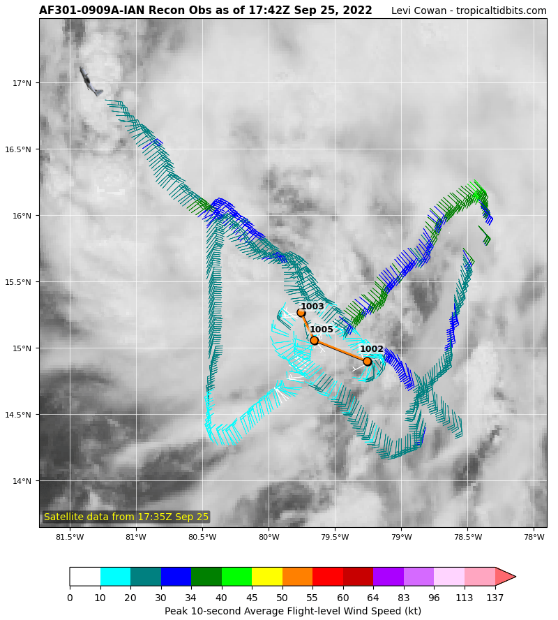
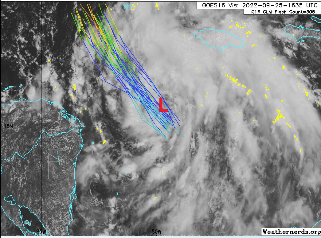
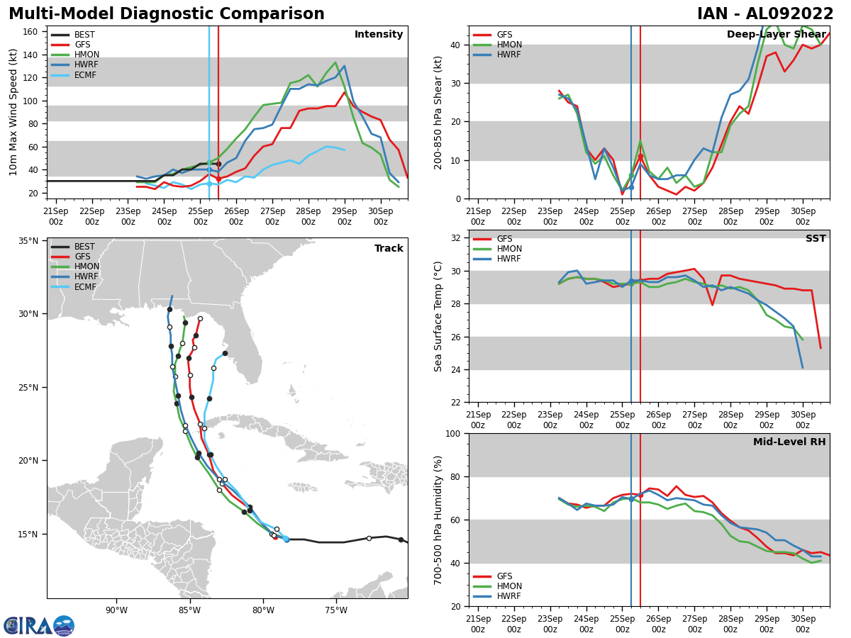
Despite a loose organizational structure, Ian remains likely to reach major hurricane intensity by the time it crosses into the eastern Gulf of Mexico on Tuesday. Sunday’s reconnaissance aircraft data shows that Ian’s mid- and low-level circulations are becoming better aligned, which is a necessary precondition for explosive strengthening. Look for probable rapid intensification starting Monday once Ian fully consolidates its vertical storm structure.
It’s not unusual for predicted rapid intensification cycles to take a little longer than expected to get going and then quickly make up for lost time once underway: Hurricanes Laura and Ida are recent examples of this. However, the delay in strengthening does have track implications. Sunday’s steering currents in the western Caribbean for a deeper, stronger storm are more oriented from east-to-west, while the guiding winds felt by a shallower, weaker storm have more of a northward component.
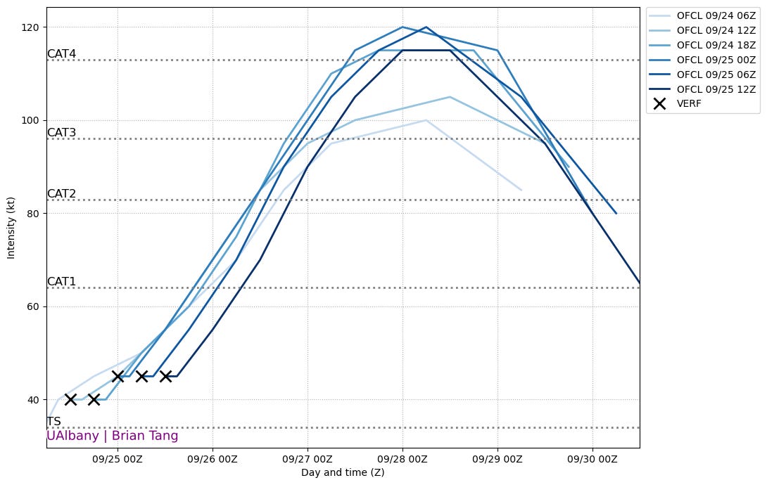
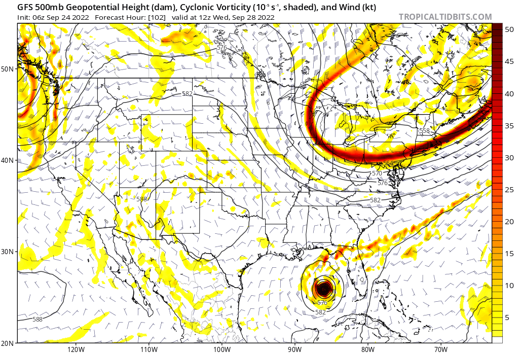
With Ian remaining weaker a bit longer, the tropical storm is starting to gain latitude as of Sunday afternoon, putting the surface circulation on the northern side of the spread in model guidance as seen above.
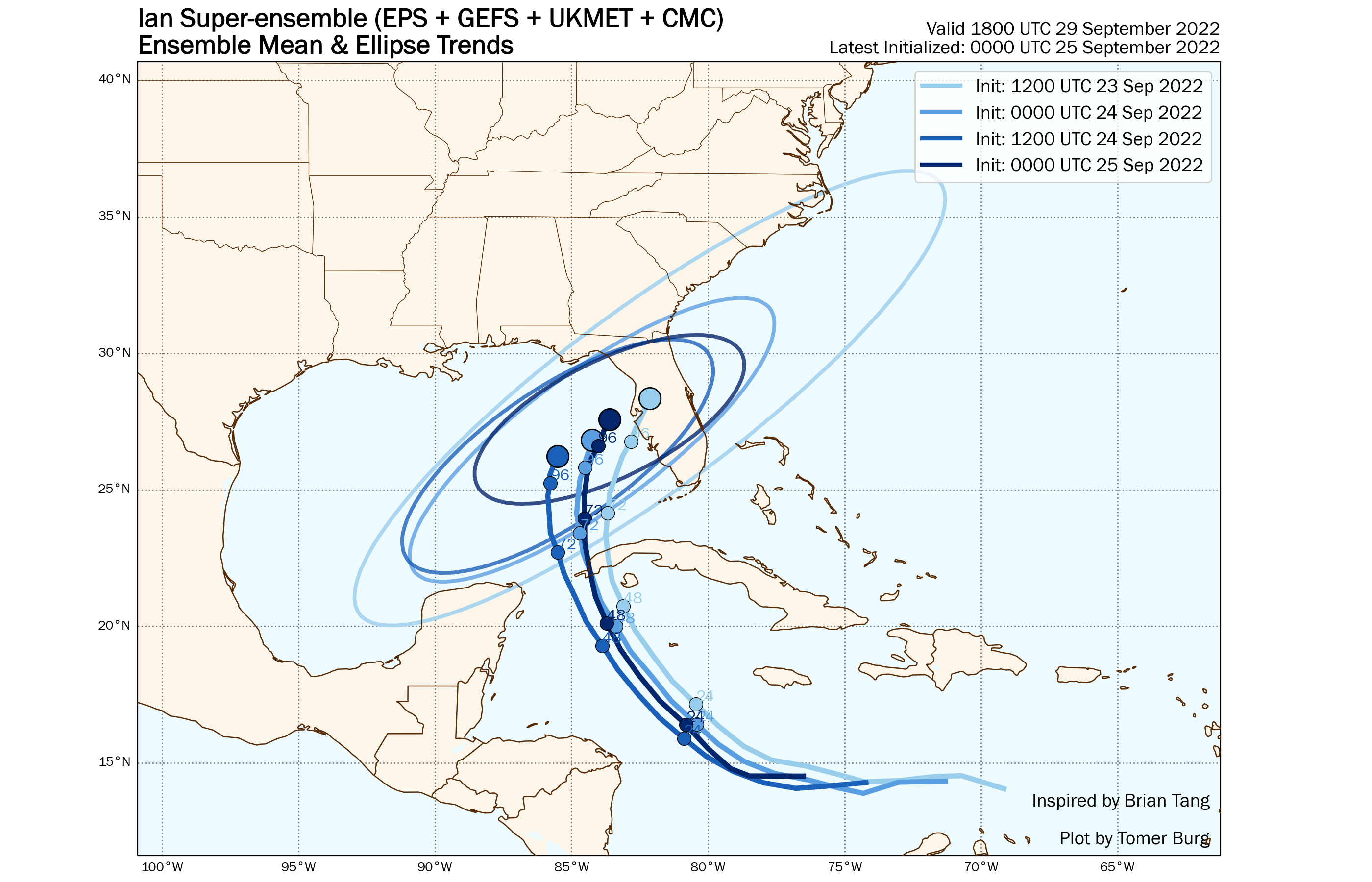
And what a spread that is, particularly once Ian enters the Gulf, when the hurricane will turn north in response to a sharp trough of upper-level low pressure over the eastern U.S. As of mid-day Sunday, the range of reputable forecast guidance extends from the western Panhandle to the Fort Myers area; the 11 a.m. NHC track forecast splits the difference between these clusters, showing a path into Apalachee Bay and directly over WeatherTiger World HQ in beautiful Tallahassee, Florida.

The split in the forecast guidance, which is larger than usual for a 3-to-4 day lead time, has two sources. First, models that are stronger with Ian over the next 24-36 hours swing the storm farther west into the Gulf of Mexico. The U.S. hurricane-specific models, the HWRF and HMON in particular, and both are overestimating the initial strength of Ian relative to what the Hurricane Hunters are observing. This likely accounts for their position as western outliers with Ian’s eventual track.
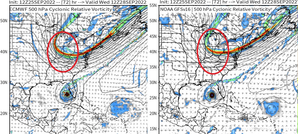
The other major disagreement is in the precise strength of the eastern U.S. steering trough midweek. The 12z European and UKMET models and their ensembles targeting west central Florida have that dip in the jet stream extending a little further south and hanging around the East Coast longer than the American GFS model, which brings Ian into the eastern Panhandle. A stronger trough would steer Ian into making a sharper and faster turn northeast and back towards Florida on Wednesday and Thursday.
Overall, the GFS is probably booting the eastern U.S. trough out-to-sea too quickly, given its bias to underestimate the strength of ridges in the western Atlantic. Recent GFS runs have also been trending stronger with this trough, hinting that Ian’s forecast may nudge a little bit back east over the next day.
Let’s see how those observations and model trends add up for four Florida impact scenarios:
Scenario 1: Keys and Southeast Florida (Minimal chance)
Ian has already moved too far west for a track through Southeast Florida. Rainfall and outer bands of Ian will move across the Keys and South Florida metro areas on Tuesday and Wednesday.
Scenario 2: Southwest Florida to Tampa Bay area (40% chance)
This region is in the eastern portion of the NHC cone of uncertainty, and a landfall in the Tampa Bay metro area or as far south as the Fort Myers vicinity is a major possibility. In addition to support from some models, delayed intensification and a trend towards slightly stronger troughing make this scenario physically plausible. Probable timing of landfall in this region would be Wednesday or early Thursday.
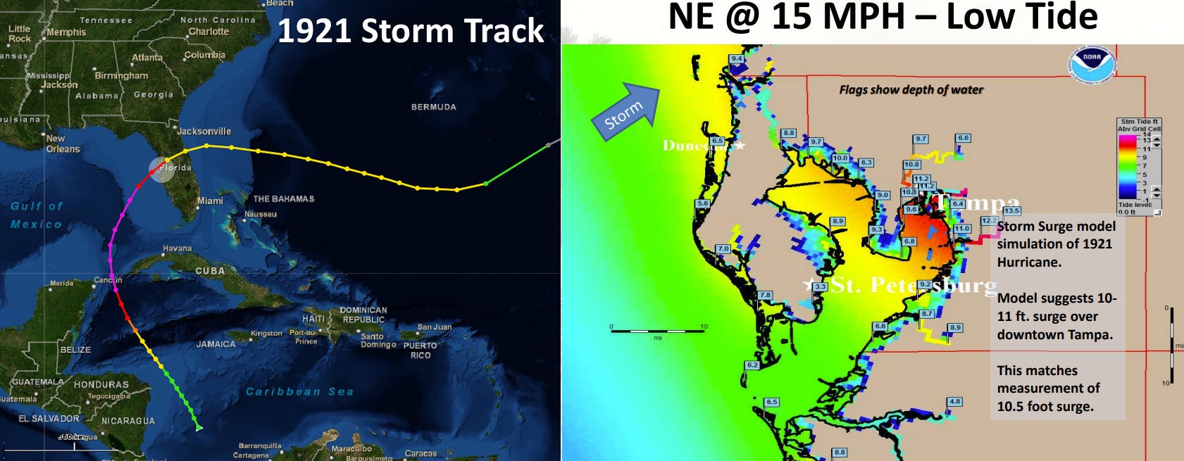
The faster Ian comes ashore, the less time it will have to weaken from its peak intensity. The last Category 3+ hurricane to directly strike the Tampa Bay region was in 1921, but that outcome is on the table. Note that major wind, wave, rain, and surge impacts are probable in this zone even without Ian making landfall near or south of Tampa.
Scenario 3: Tampa Bay area to Apalachee Bay (40% chance)
This outcome lies between the eastern and western clusters of modeling, and is the NHC official forecast as of mid-day Sunday, with a possible timing of landfall late Thursday or Friday. The longer Ian remains over the water, the more time wind shear and drier air to the west will have to scour the storm’s core, so a Thursday landfall in this region would likely deliver a more concentrated windfield with higher maximum sustained winds.
If the trough departs faster and Ian remains offshore south of the Big Bend on Thursday while moving more slowly north, an extended period of wind, rain, and especially destructive surge and waves over portions of this region would continue through Friday landfall, even though maximum winds would be diminished.
Scenario 4: West of Apalachee Bay (20% chance)
Current trends towards Ian moving a little further north through Monday and stronger troughing are tilting the odds of a landfall from the Panama City area west a bit lower this afternoon. However, the entire Panhandle should continue to watch Ian closely, and inclement weather will extend far from the storm’s center.
Keep in mind that these odds reflect general scenarios for possible tracks of Ian’s center. Hurricanes are not a point, and major wind, rain, and surge impacts are likely across much of the Florida peninsula and Gulf Coast no matter which of these scenarios play out. I would expect that the currently messy forecast guidance will start to home in on a more manageable range of possibilities on Monday. In the meantime, keep watching the skies.
Feel free to share this post with anyone you think would enjoy it.
Thank you Dr. Truchelut. This will really help explain these different scenarios to others.