Hurricane Ian Landfall Live Blog [Final Post: 6:30p.m.]
Tracking Ian moment-by-moment through landfall and beyond.
WeatherTiger’s Hurricane Ian landfall liveblog will update continuously through around 6:30 p.m. this evening.
Email users: Click here to access the newest version of the live blog throughout the day.
Web users: Refresh this page. New posts will appear at top.
6:30p: Signing off
With Ian moving inland, the focus now turns to the next 24-36 hours of tornado, surge, rain, and wind impacts for Central Florida and North Florida, and the emerging flood and surge threat to the Carolinas beyond that that I’ve laid out in previous posts. Surge and wind destruction is continuing at the moment in Southwest Florida, and will gradually subside tonight. The full picture of today’s calamity will take time to emerge, but the initial signs are not good. It is clear that Southwest Florida has taken a brutal hit with few parallels in their hurricane history.
As I sign off for the evening, residents of Southwest, Central, and Northeast Florida should continue to closely monitoring the latest information from the National Hurricane Center, your local National Weather Service office, and emergency management. Residents of the Big Bend and Panhandle should be thanking your lucky stars that this one didn’t have our name on it.
I’ll be back tomorrow morning to recap overnight developments and lay out Thursday’s threats to Florida from Ian. Until then, good night, and keep watching the skies.
6:20p: Threats Moving Forward #4: Winds
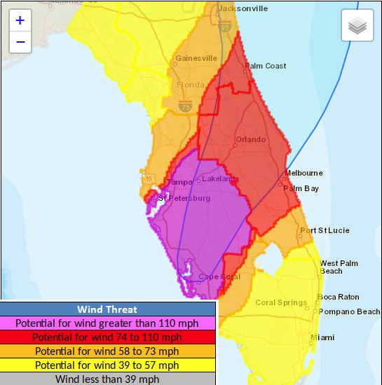
As I start to wrap up today’s live coverage of Hurricane Ian, the last threat to discuss is wind impacts. Obviously, these have already been catastrophic across much of coastal Southwest Florida today, but significant wind impacts will continue into the overnight hours for inland Southwest Florida and west Central Florida and potentially into tomorrow for east Central and Northeast Florida. The areas in purple on the NWS wind threat map above are those that will potentially see 110 mph+ gusts overnight; not everyone in this area will see gusts that strong, but some likely will.
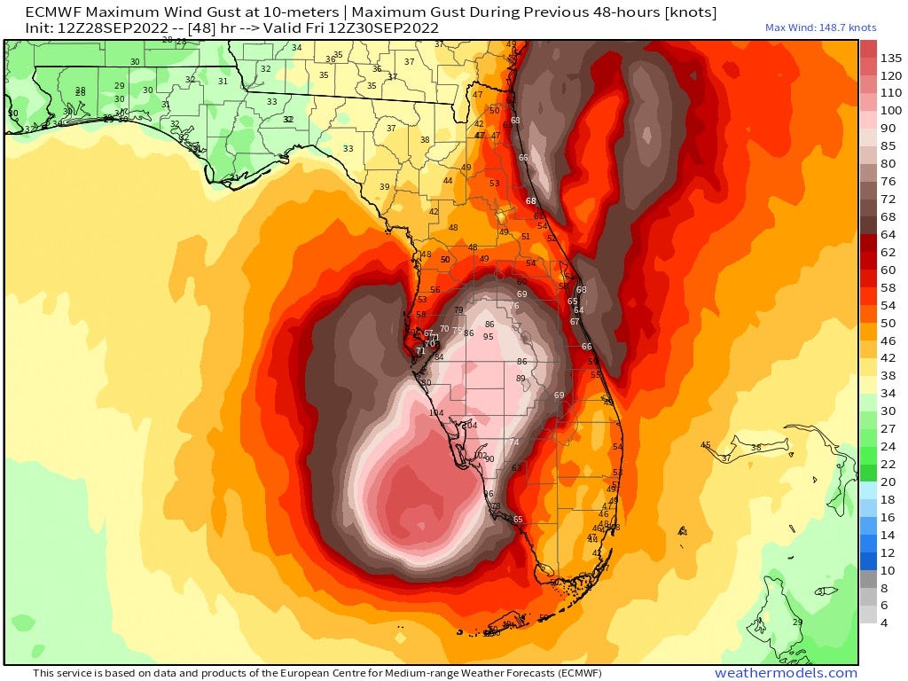
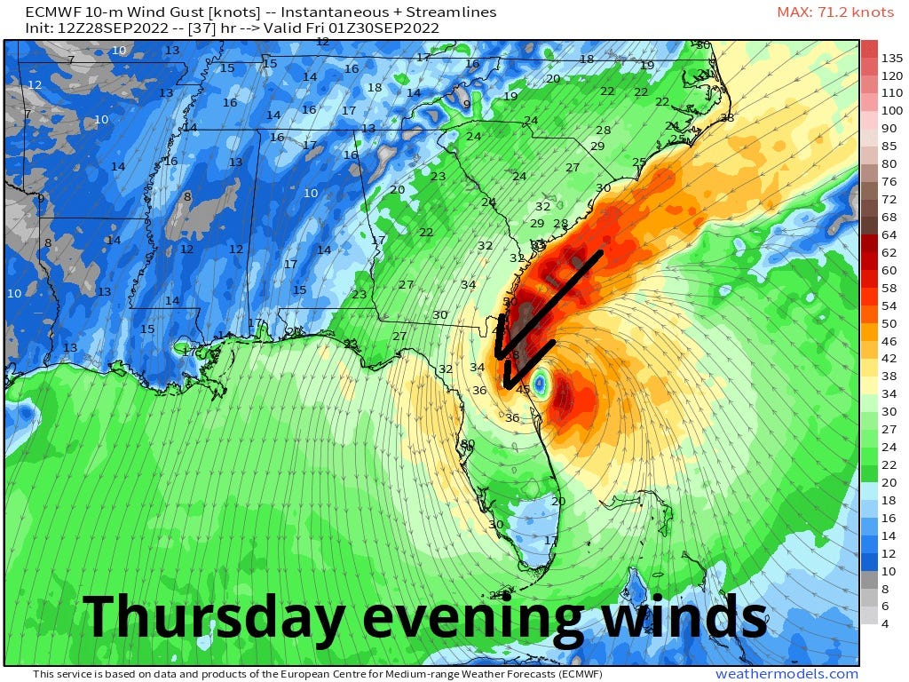
The area in red in east central Florida has a possibility of seeing hurricane force wind gusts tomorrow, but this is dependent on how long Ian’s core holds together over land. On the 12z Euro maximum gust map above, note that the hurricane-force gusts in brown abruptly end in south Orlando as the inner structure of Ian degrades tomorrow morning, with tropical storm force max gusts in the 50s and 60s for the rest of Central Florida through Thursday afternoon. This may be a more realistic picture of Ian’s inland wind impacts, which will still cause tree damage and power outages across Central Florida even in an optimistic scenario.
Note also that coastal gusts in Northeast Florida may approach hurricane force late Thursday into early Friday should Ian attempt to restrengthen when it reaches the Atlantic in around 24 hours.
6:05p: Southwest Florida Warnings
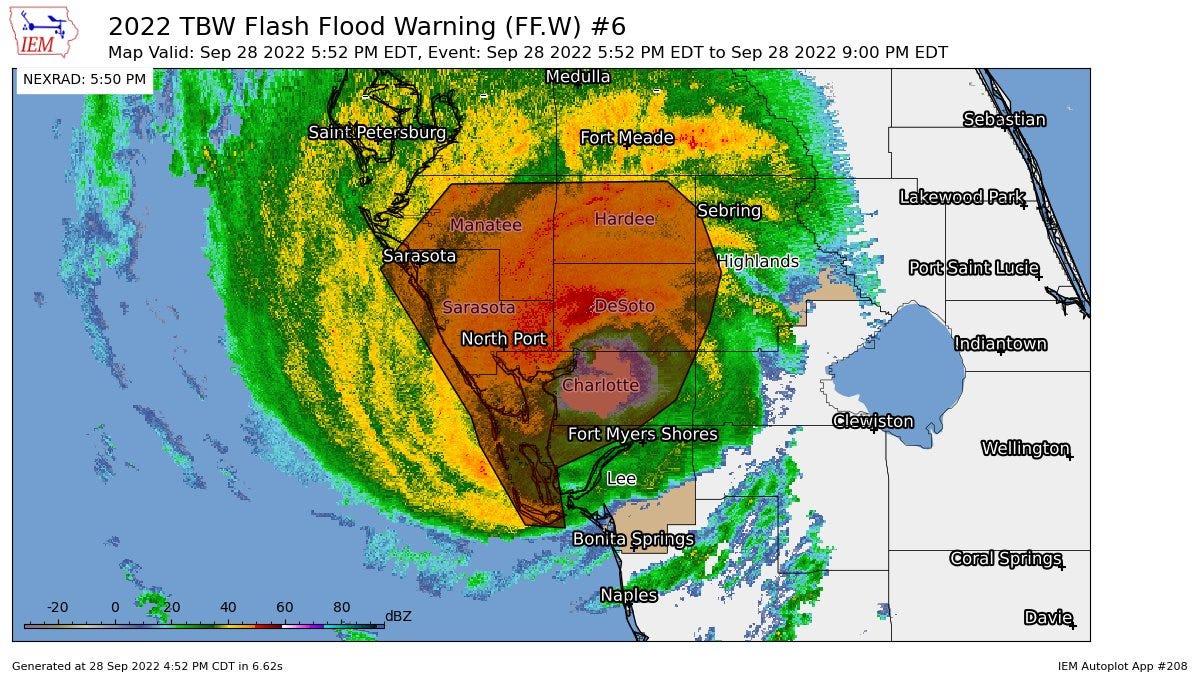
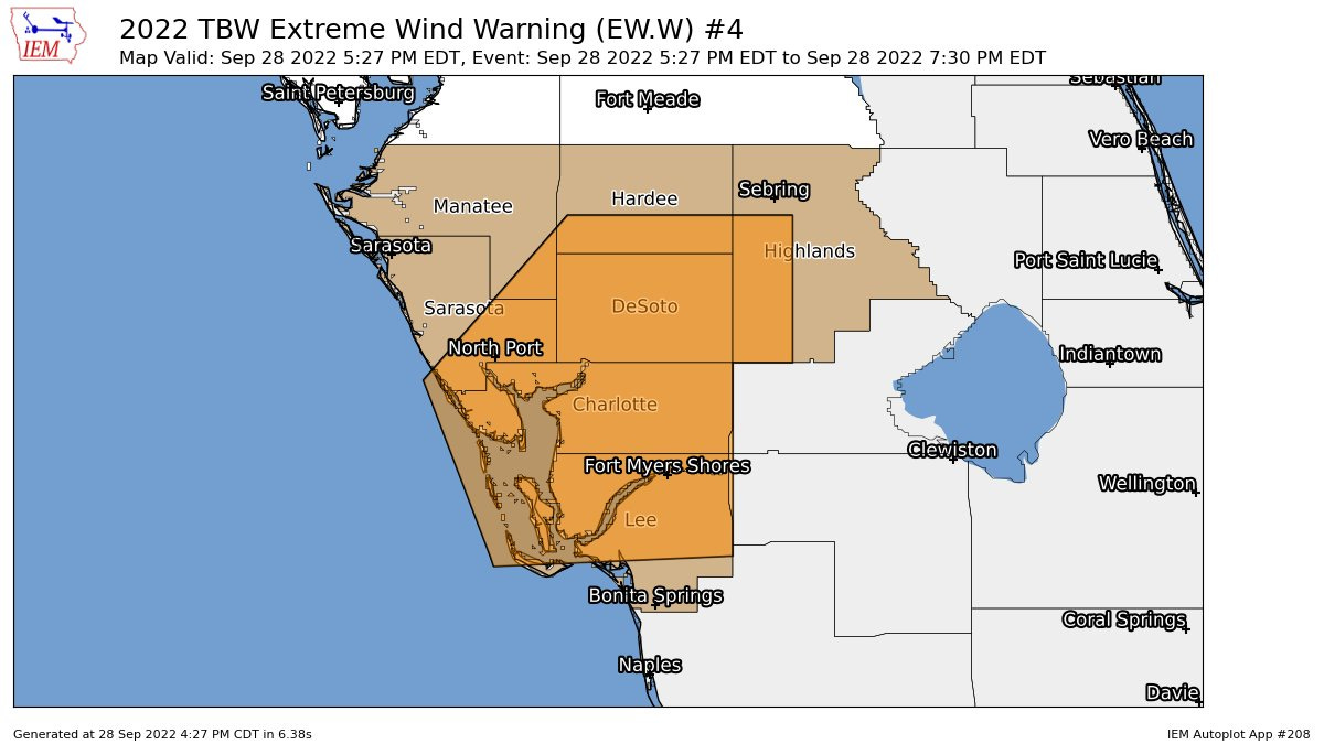
Much of Southwest Florida between Fort Myers and the southern Tampa Bay area remains under one or both of an Extreme Wind Warning for the northwest eyewall of Ian, and/or a Flash Flood Warning due to short-term accumulations of over 6” of rainfall in several hours in these areas.
Stay in an interior room and away from windows if you are under an Extreme Wind Warning.
5:55p: Threats Moving Forward #3: Rainfall
The updated 5 p.m. outlook for extreme rainfall and risks narrows and focuses the area at greatest threat of flash flooding. With dry air already cutting into rain coverage east of Ian’s center, the greatest flood potential going along with 10”+ rainfall totals through Friday will extend roughly from Tampa to Daytona Beach to Jacksonville, along and north of I-4.
The heaviest rainfall is expected in Central Florida tonight into early tomorrow, and in North Florida tomorrow through early Friday. Ian is also a flood risk for the Carolinas into the weekend, after making a second landfall somewhere near Savannah late Friday.
5:45p: Threats Moving Forward #2: Surge
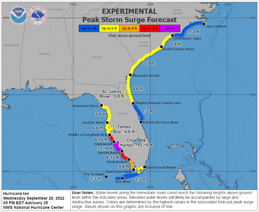
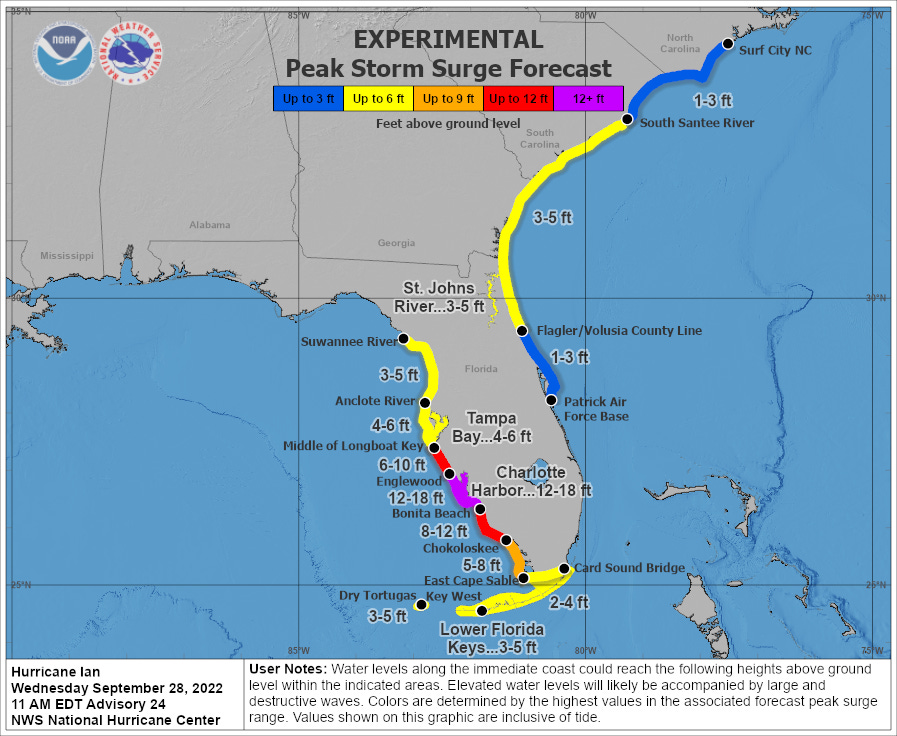
The NHC peak surge expectations for Southwest Florida have not changed as of the 5 pm advisory, where by all reports these values are unfortunately being met south of Charlotte Harbor, with devastating results.
Surge expectations in northeast Florida have continued to tick higher since yesterday, and are now 4-6’ along the First Coast and coastal Georgia, and 3-5’ in the Saint Johns River. Peak surge is likely in these areas late Thursday into early Friday, as Ian moves back offshore and then arcs toward coastal Georgia, pointing a strong onshore flow of tropical storm force winds towards Northeast Florida, including the Jacksonville area.
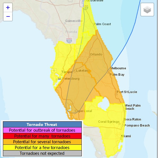
5:30p: Threats Moving Forward #1: Tornadoes
With the new NHC advisory package and track issued at 5 pm, there are also updated predictions for each of the four hurricane hazards—surge, wind, rain, and tornadoes—that Florida will continue to face over the next 36 hours.
There have been numerous confirmed tornadoes in bands east of the center over the last two days, and the tornado threat will continue through the night tonight into tomorrow morning.
The threat is currently most acute in east Central Florida, where a Tornado Watch is in place, and should end by midday tomorrow as dry air wraps east of Ian’s circulation center.
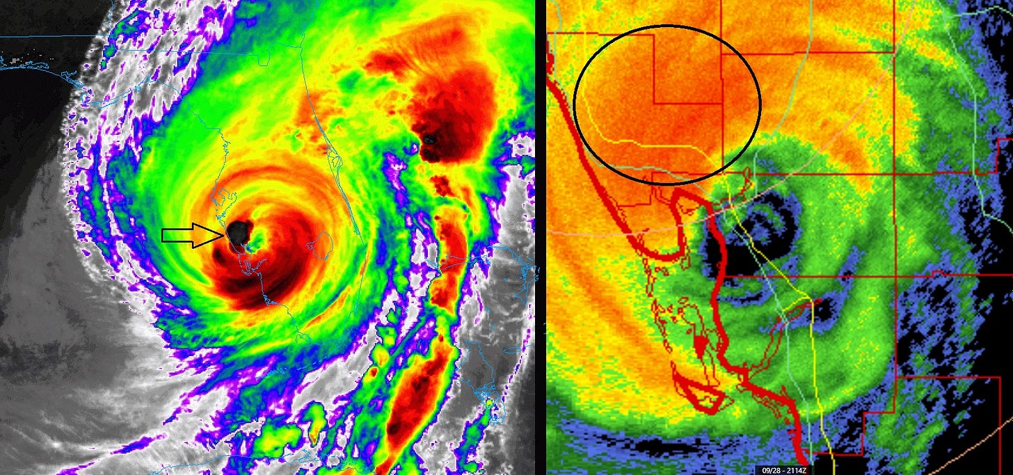
5:20p: Convective burst
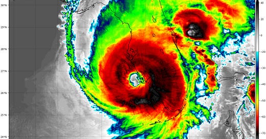
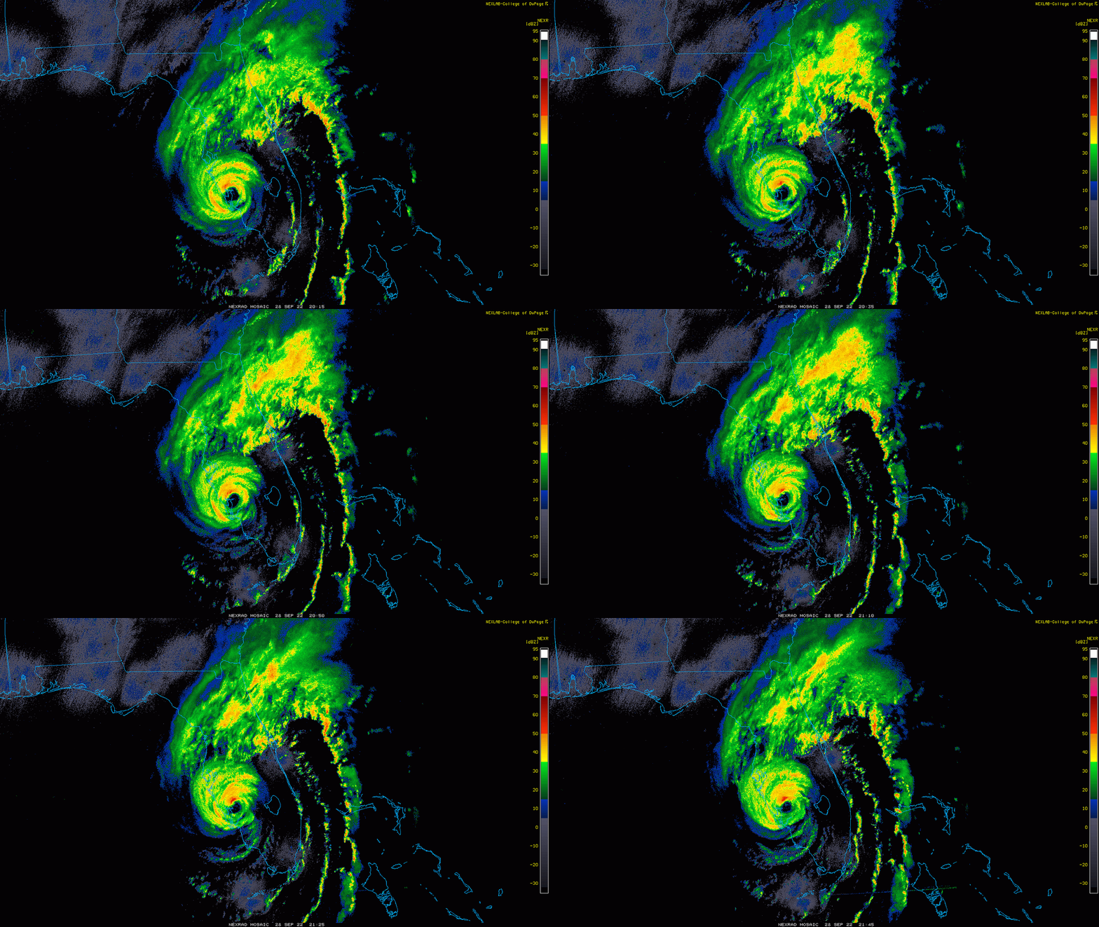
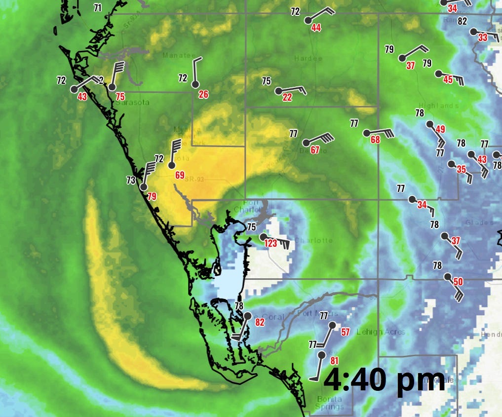
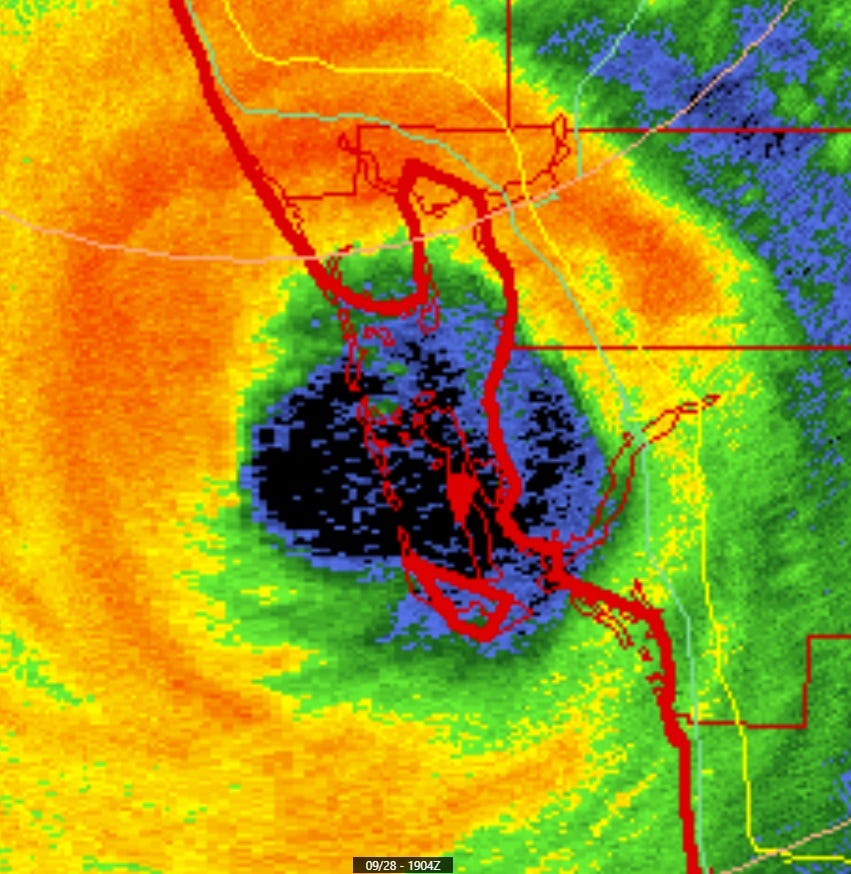
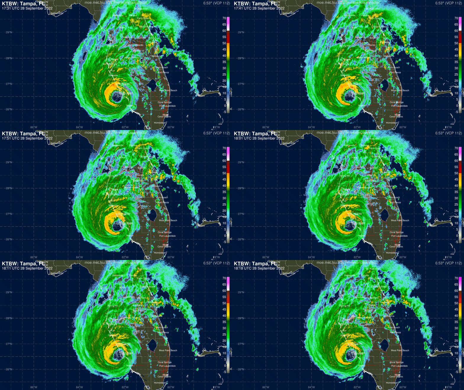
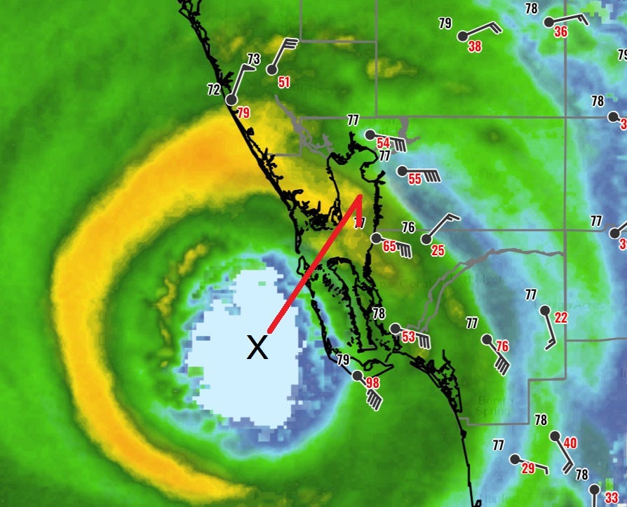
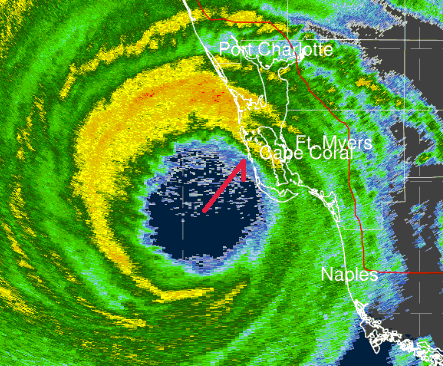
Unfortunately, Ian is still sending up new convective bursts in its western eyewall even after landfall. This is likely to lead to destructive wind gusts to 115 mph or greater in the portion of northwestern eyewall highlighted on radar above. Not what you want to see post-landfall.
By all accounts, life-threatening surge is continuing to build in the areas south of the center where strong winds are out of the west and southwest.
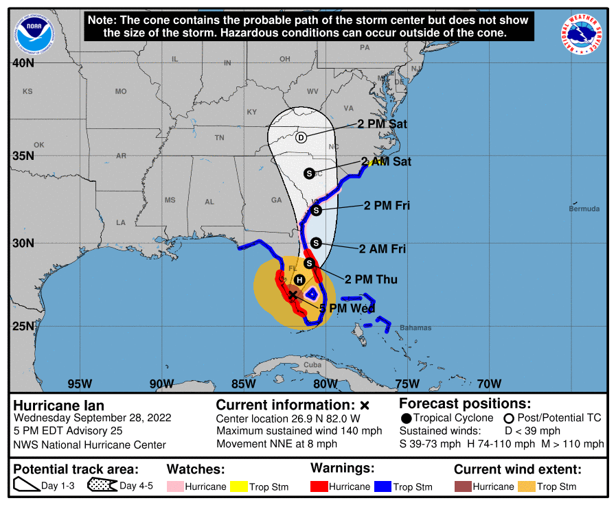
5:05p: New NHC advisory package
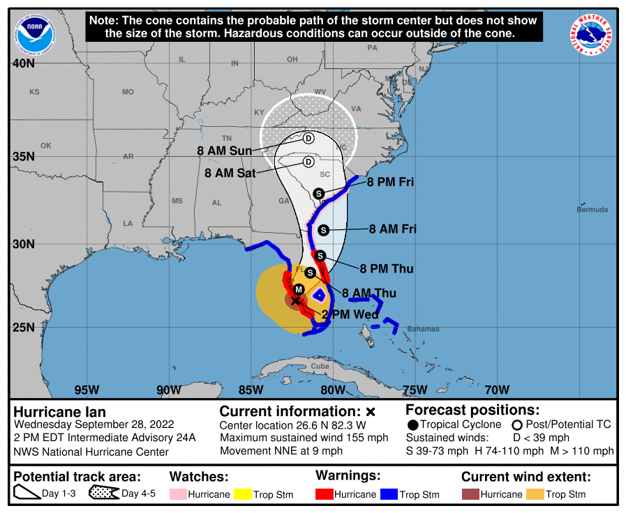
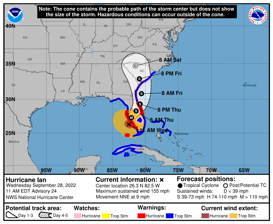
The brand new NHC 5 p.m. advisory has Ian located about 5 miles east of Punta Gorda, inland over Charlotte County. Winds are down to 140 mph, and movement is now north-northeast on a 20 degree heading at 8 mph.
The new track has Ian crossing Central Florida over the next 24 hours, and emerging back into the Atlantic late tomorrow.
Will dig in on the updated impacts in subsequent posts.
4:55p: Still cranking
While Ian is now inland over Charlotte County, destructive wind and surge threats are by no means over in Southwest Florida. NWS Tampa Bay received a report at 4:30pm of sustained 112 mph winds in Cape Coral with a gust to 135 mph, and wind gusts over 115 mph are still expected where the formidable northern and eastern eyewall are moving over southern Sarasota, southwest Manatee, Desoto, and Charlotte Counties over the next hour.
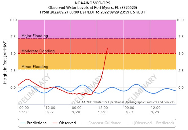
Additionally, winds out of the southwest are still piling destructive surge into Southwest Florida south of Charlotte Harbor. Water levels continue to rise in Mort Myers.
Standing by for new advisory from NHC at 5pm with updated track and impacts graphics.
4:45p: Charley Comparison, Part 2: Differences
While Charley and Ian share a landfall point, intensity, and track, there are some key differences that makes the threats posed by each storm quite different, especially from this point on.
First key difference: forward speed. Charley raced north-northeast at around 25 mph after reaching Charlotte Harbor at 4 pm, exiting the Florida peninsula near Daytona Beach around midnight. In contrast, Ian is moving at around 8-9 mph, and will likely slow down more overnight.
Second key difference: intensity trend. Charley made landfall in the middle of a rapid intensification cycle, with winds increasing 35 kt in the 7 hours prior to landfall. Ian finished a rapid intensification cycle about 7 hours before landfall, plateauing as it reached land.
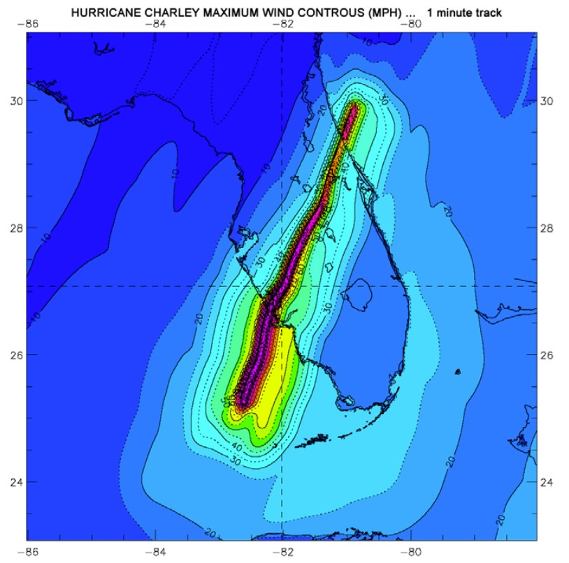
These two differences mean Charley was extraordinarily effective at bringing damaging winds deep inland. Strengthening storms are more effective at bringing winds aloft to the surface as gusts, and Charley’s decay over land was slow enough that the hurricane’s core was still intact in Central Florida 4-6 hours after landfall, including a 105 mph gust recorded at Orlando Airport.
The tale is yet to be told with Ian, but the slower motion and flat intensity trend into landfall, should mean much lower wind gusts across Central Florida than seen
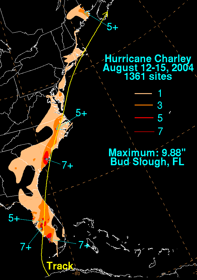
Finally, Ian is much larger than Charley, and so will cause far more widespread rainfall impacts in the state; most areas of Southwest and Central Florida saw only 2-4” of rain from Charley, but may crack 10” or more with Ian.
I’ll be taking a closer look at the impacts of the days ahead with Ian in the next hour.
4:20p: Broader wind impacts
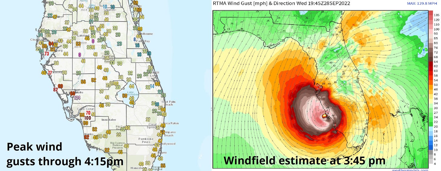
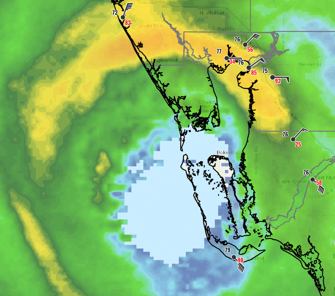
Checking in on today’s maximum wind gusts observed so far during Ian, hurricane force wind gusts and above are so far mostly limited to the southern Tampa Bay area south to Naples, and around 20 miles inland across Southwest Florida so far. That matches up well with current windfield estimates.
Look for stronger gusts to advance inland as Ian leaves Charlotte Harbor behind in the next hour.
Part 2 of the Charley comparison coming up next.
4:05pm: NHC hourly update
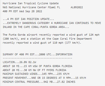
The latest NHC hourly position and intensity update has Ian still over Charlotte Harbor, with sustained winds down another tick to 145 mph and pressure up 2mb to 942 mb.
Punta Gorda, just now entering the eye, reported a wind gust of 124 mph in the last hour.
4:00p: Satellite appearance changing
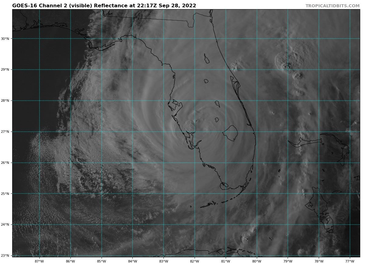
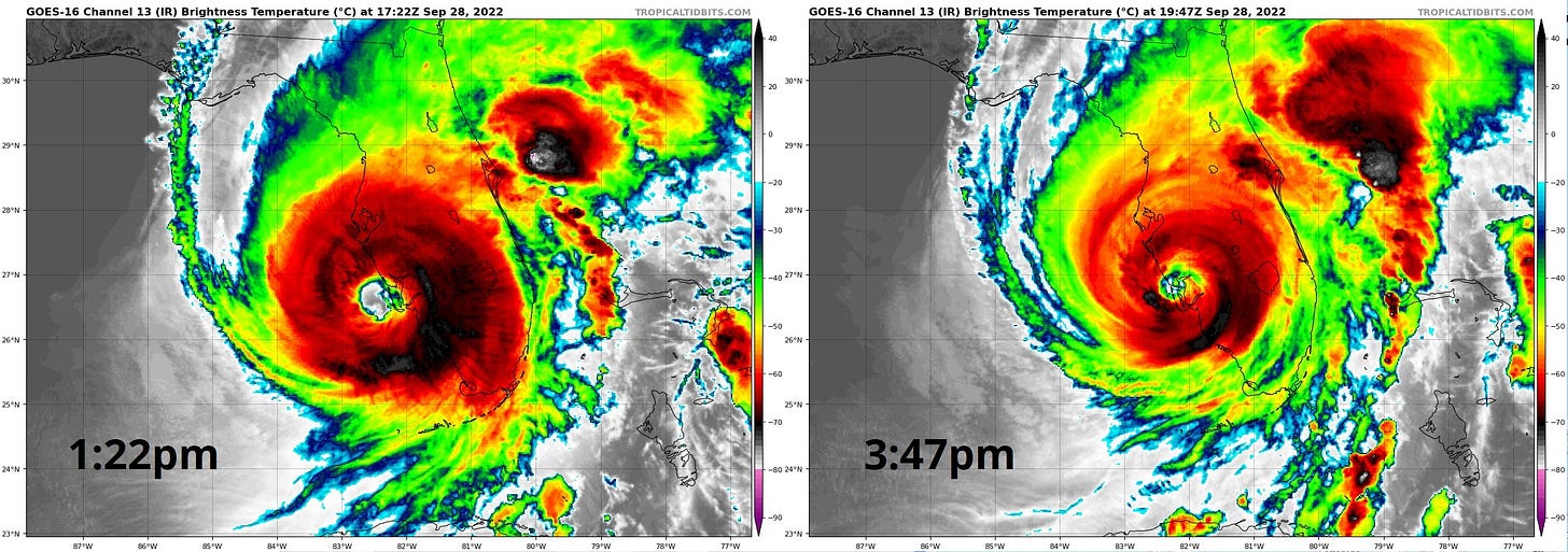
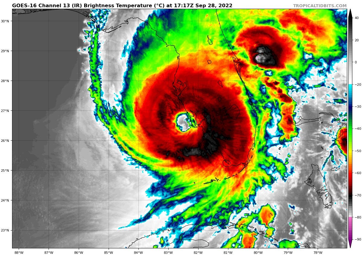
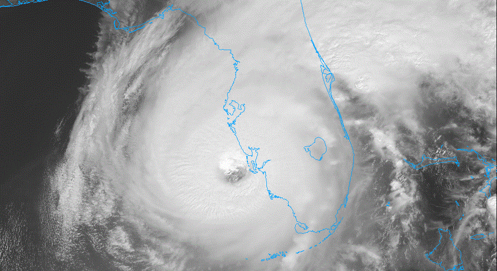
As Ian begins to move inland this afternoon, convection is becoming a little less intense and symmetrical, and the hurricane’s eye is becoming less clear compared to just two and a half hours ago. While Ian is still a powerful hurricane and any hint of weakening arrived far too little, too late for Southwest Florida, increasing shear out of the southwest and dry air to Ian’s west may start to weaken the inner core of the storm more quickly now that it is nearly cut off from its oceanic energy supply.
3:50p: Flash Flood Warning
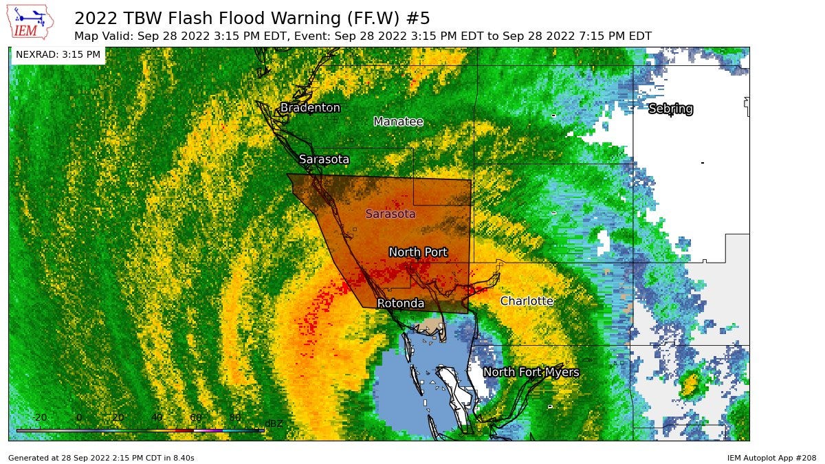
Before getting back to the Charley comparison, a new Flash Flood Warning is in effect for much of Sarasota County due to excessive rainfall from the northern eyewall in this area. While Charlotte Harbor and vicinity are continuing to suffer the extreme wind and surge associated with Ian’s eyewall, flash flooding is a very real risk here as well.
3:40p: Charley Comparison, Part 1: Similarities
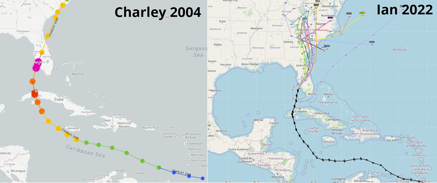
As Ian treks northeast across Charlotte Harbor just as Hurricane Charley did 18 years before, it’s worth noting how similar the tracks of the two hurricanes are.
Both took an unusual track that saw initial development in the usually hostile eastern Caribbean, followed by curves across western Cuba to a landfall point in Charlotte Harbor. Additionally, their maximum sustained winds at landfall are equal: 150 mph, tied for fifth-strongest continental U.S. landfall in hurricane history. Even their minimum pressures at first landfall are nearly indentical; 940 mb for Ian vs. 941 mb for Charley. And unfortunately, both are likely to do catastrophic wind damage in Southwest Florida.
3:15p: Official Landfall at Cayo Costa
The NHC has issued a statement confirming that Hurricane Ian official made first landfall at 3:05p.m. ET near Cayo Costa, a barrier island in the mouth of Charlotte Harbor.
Maximum sustained winds at landfall were estimated to be near 150 mph, precisely matching Hurricane Charley’s sustained winds at landfall 18 years ago.
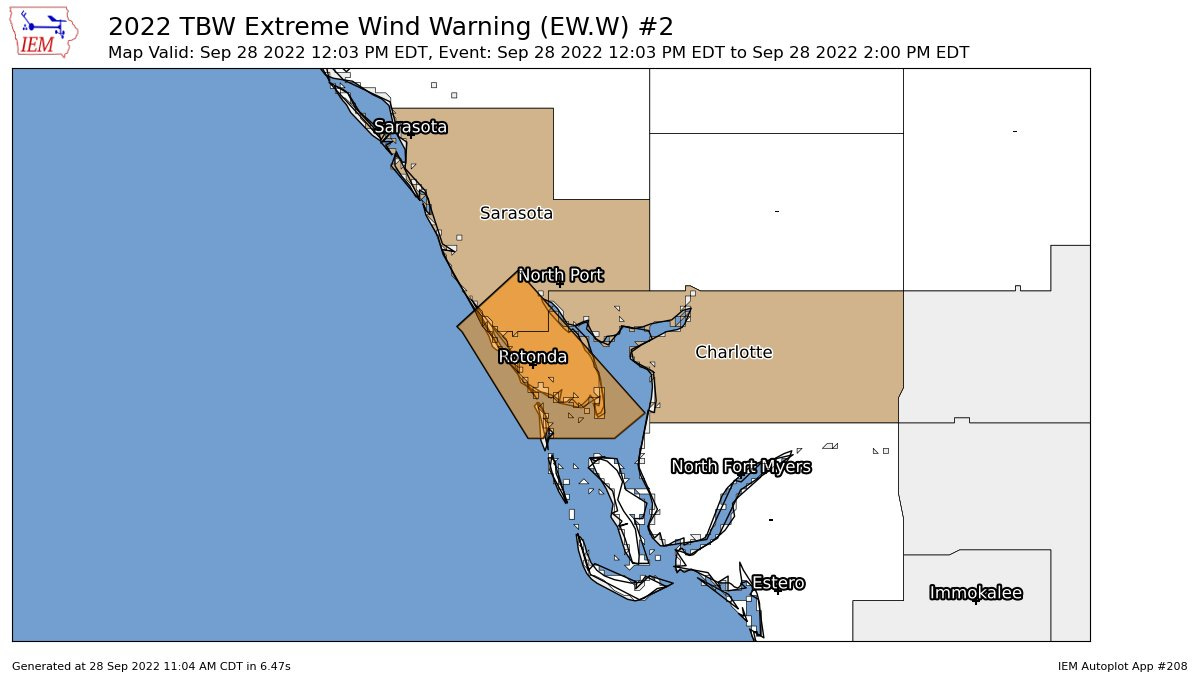
3:10p: New Extreme Wind Warning
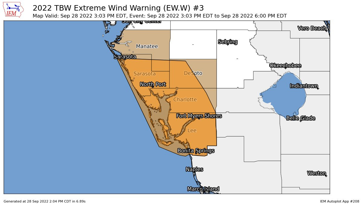
NWS Tampa Bay has issued an updated and much larger Extreme Wind Warning for all of Charlotte, Lee, Sarasota Counties, as well as western Desoto County and SE Manatee County. I will let the text of the Warning speak for itself.
At 303 PM EDT, National Weather Service Doppler radar indicated
  extreme winds, associated with the eyewall of Hurricane Ian, were
  moving onshore near North Port, moving northeast at 5 mph.
  THIS IS AN EXTREMELY DANGEROUS AND LIFE-THREATENING SITUATION!

PRECAUTIONARY/PREPAREDNESS ACTIONS...

TAKE COVER NOW! Treat these imminent extreme winds as if a tornado
was approaching and move immediately to the safe room in your
shelter. Take action now to protect your life!
3:05p: NHC update
Per the NHC 3 p.m. update statement, Hurricane Ian is about to make landfall with sustained winds remaining at 155 mph. Continued northeast motion will bring Ian fully onshore in Southwest Florida within 1-2 hours, after it finishes traversing Charlotte Harbor.
Extreme wind and surge impacts are continuing across Southwest Florida at this hour, with the NWS Tampa Bay office receiving multiple reports of surge up to first story roofs in Ft. Myers Beach and a 118 mph gust reported in Cape Coral.
2:50p: Exceedingly close to landfall
Per radar, Ian’s center is located very close to North Captiva Island and Cayo Costa, and official landfall is likely to be declared any minute now.
The extremely powerful inner eyewall continues to rake Venice, Englewood, Port Charlotte, Punta Gorda, and south. Weather stations are starting to go down, but Punta Gorda just recorded a 110 mph wind gust.
2:35p: Rainfall check
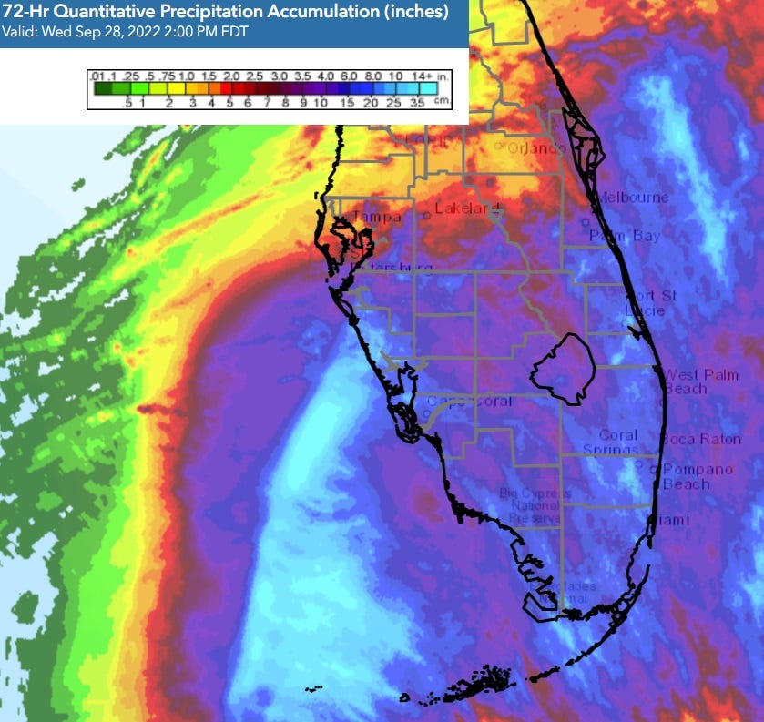
As we await landfall in the next half hour, let’s zoom out and take a look at heavy rainfall that Ian is spreading across much of Florida today, even well away from the region of catastrophic surge and wind impacts in Southwest Florida. While Tampa will fortunately miss out on the surge, torrential rain currently falling there and continuing into tomorrow is likely to cause significant flash and freshwater flooding issues. Heavy rain also continues in Central Florida and Northeast Florida.
Just a reminder that a hurricane is not a point, and Ian will have widespread wind, rain, and surge impacts over the next 48 hours, which I will cover later in the liveblog. Three-day rainfall totals across South and Central Florida in the areas in blue already range from 5-10”, as shown above.
2:20p: Last call for recon
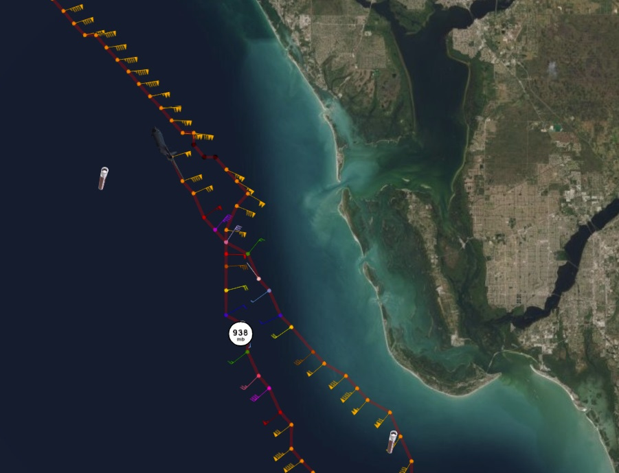
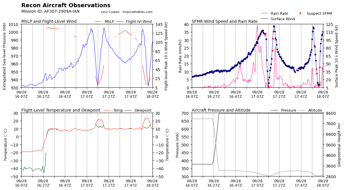
An Air Force Reserve Hurricane Hunter aircraft just made what is likely the final pass through the center of Hurricane Ian prior to landfall. Recon is confirming a continued northeast to north-northeast movement.
Their observations also suggest Ian’s intensity has plateaued at high-end Category 4 status; while Ian is certainly not weakening, pressures have not lowered nor have flight-level or surface estimated winds increased since the morning recon missions.
2:10p: Historical context
Within the hour, Hurricane Ian will become the 14th Category 4 or 5 hurricane to make landfall in the state of Florida in the last 100 years.
Charlotte Harbor was most recently struck by Hurricane Charley in 2004— much more on the Charley comparison later. However, note that Cat 4/5 landfalls are very rare on the Gulf Coast.
2:00p: New NHC advisory
The 2 p.m. intermediate advisory from the NHC is hot off the press. Maximum sustained winds are unchanged at 155 mph, a high-end Category 4 on the Saffir-Simpson Hurricane Wind Scale. It does not appear that Ian will strengthen further prior to landfall.
Ian is now per NHC reckoning moving north-northeast at 9 mph. This path should bring Ian over the barrier islands in the next hour. Next full advisory package updating the track forecast will be at 5 p.m.
1:50p: Sanibel and Captiva moving into eye
With the center of Ian now just 10 miles southwest of Boca Grande at the mouth of Charlotte Harbor, portions of Captiva and Sanibel are moving into the calmer eye as the northeast eyewall pushes towards Port Charlotte and the northern eyewall is nearing Venice. On this heading, Ian will make landfall in 60-90 minutes on the barrier island of Boca Grande or very close.
Extreme Wind Warnings remain in effect for portions of Lee, Charlotte, and Sarasota Counties, reflecting the imminent arrival or ongoing 115 mph+ winds capable of causing structural damage.
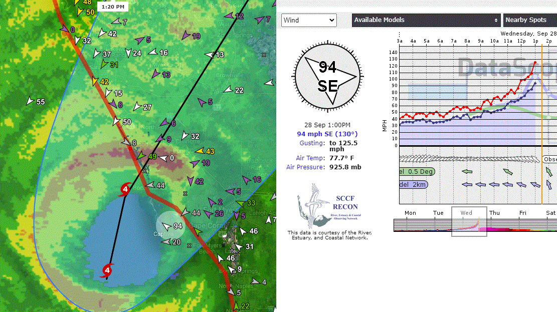
1:35p: New top gust of 126 mph
As Hurricane Ian’s inner eyewall continues to push north and east, Sanibel and Captiva are seeing the full brunt of the hurricane’s core.
A maximum gust of around 126 mph was recorded near Captiva around 1 p.m. before contact with the station was lost. This is the highest gust I have yet seen.
Englewood is in the heart of the northern eyewall right now and likely seeing wind gusts in the 130-150 mph range or greater.
1:25p: Fearful symmetry
There’s no other words for this.
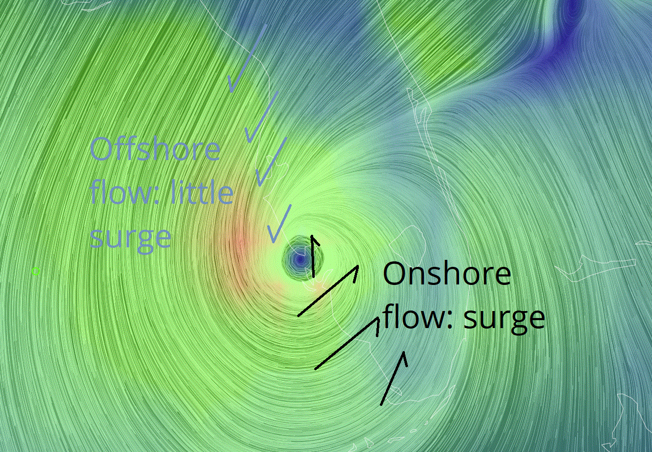
1:20p: Where will the surge be destructive?
In response to a reader question on the expected surge impacts, here’s a rough look at where in Southwest Florida will or won’t see the NHC worst-case scenario surge forecasts verify.
With Ian coming ashore in or near Port Charlotte, it is Charlotte Harbor and areas 30-40 miles south and east of the landfall point that will see life-threatening and destructive surge, as winds out of the south and west push water ashore. Areas northwest of the landfall point, including Tampa Bay, will see minimal surge impacts. A real bullet dodged in Tampa, at great cost for areas farther south in Southwest FL.
1:10p: Surge threat coming true
Foremost amongst a hurricane’s deadly threats is storm surge. Ian’s large windfield will drive a 12-18’ wall of water into Charlotte Harbor and areas southeast of the landfall point as it comes ashore this afternoon, per NHC model guidance.
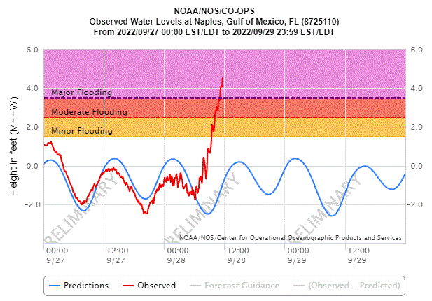
The projections in these forecasts are already verifying; a tidal gauge in Naples is already reporting nearly 6’ of surge, with the tide still coming in for a few more hours.
1:00p: NHC position update
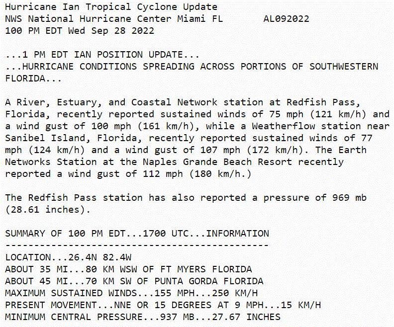
Per the NHC’s 1 p.m. position and intensity update, Ian continues to have maximum sustained winds of 155 mph. Several wind gust reports in excess of 100 mph have also been received from the areas under Extreme Wind Warnings.
12:55p: Angling northeast
Tracking Ian’s eyewall radar image by radar image, the hurricane has been moving more northeast than north-northeast over the last few hours. This accelerates the landfall timeline.
On its current heading, the center of Ian will be passing very close to Boca Grande at the mouth of Charlotte Harbor within the next two hours, and subsequently moving up the harbor into the mid-afternoon.
The northern eyewall is now approaching Englewood and wind gusts of 115 mph+ are likely to begin there soon.
12:45p: Eastern eyewall moving ashore
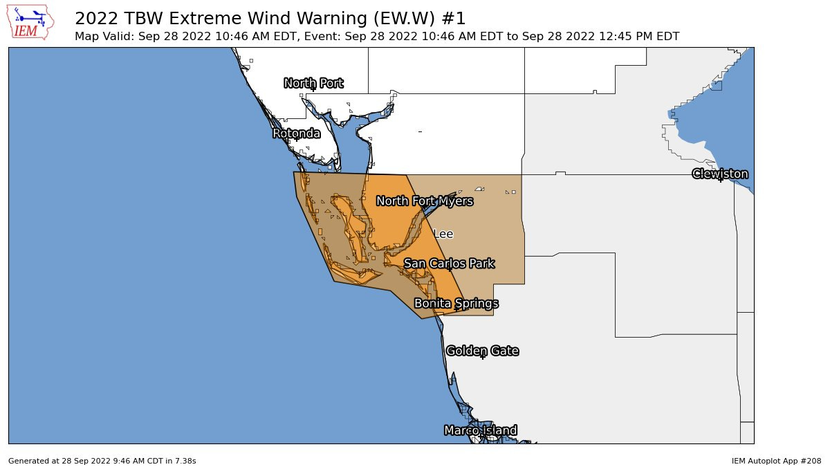
With the eastern eyewall of Hurricane Ian pushing across Sanibel, Captiva, and the barrier islands of Charlotte Harbor, the NWS has issued the rare Extreme Wind Warnings for portions of Charlotte, Sarasota, and Lee Counties as of 12:45pm. The areas of those Warnings are shown here:
The National Weather Service issues Extreme Wind Warnings for the areas directly impacted by the eyewall and likely to see wind gusts at or above 115 mph. You need to treat these as you would a Tornado Warning– doing so may very well save your life. If you are under an Extreme Wind Warning, go immediately to a windowless, interior room in a sound structure and remain there until the warning expires.
12:30p: Welcome and Overview
Welcome to WeatherTiger’s Hurricane Ian landfall live blog. If you’ve never read WeatherTiger’s Hurricane Watch prior to this, I’m Ryan Truchelut, Chief Meteorologist at WeatherTiger, a Tallahassee-based weather consulting and forecasting company. In addition to my professional forecasting experience, I’ve been researching hurricanes for over 15 years and graduated from FSU’s doctoral meteorology program. I also went through the eye of Hurricane Charley. I’ve been preparing for days like this my entire life.
Over the next 7 hours or so, I’ll be frequently updating this page with my insights on minute-by-minute developments with Hurricane Ian: the latest NHC advisories, NWS Warnings, local weather observations, and my forecasting insights on all aspects of this catastrophic storm. My goal is to keep you safe by providing accurate, no-hype, no-lag expert information until Ian is inland.
If you’re just getting caught up on Hurricane Ian, well, it’s been a morning like just a handful of others in hurricane history. Ian strengthened from a Category 3 to a high-end Category 4 hurricane overnight and maximum sustained winds are now estimated at 155 mph, or category 4 intensity on the Saffir-Simpson Hurricane Wind Scale. It is possible that Ian intensifies just a little more and becomes a Category 5 hurricane by landfall, which is expected just west of Port Charlotte in several hours, likely between 2-5pm. The powerful eyewall is already clipping the barrier islands.
Massive surge, wind, and rain impacts will last through tomorrow across much of Florida. I’ll dig into all these risks and more in subsequent posts. You can also watch a replay of our watch our Noon ET live forecast below to get up to speed. Welcome, and stay safe, Florida.
12:00p: Live forecast video
Replay of our Noon ET live landfall forecast for Hurricane Ian, covering surge, wind, rain, and tornado threats to Florida.








Live in West Villages, between Northport and Venice. Currently on a road trip out of state but have been monitoring my Tempest Weather Station all day. Currently 18" of rain for the day, wind steady NNW AT 18, gust 39.1.
I feel we got lucky being on the north side of the storm, will continue to monitor as long as I have power and internet at home.
Thinking the next 3 - 4 hours will be the worst.
What will the water in Tampa bay do?