WeatherTiger's Tropical Depression 9 Forecast Analysis for September 23rd
Tropical Depression 9 has developed and the NHC is already calling for a major hurricane landfall in Florida next week.
If you are a paid subscriber, thank you for your continued support of WeatherTiger.
If you are a free subscriber or new to WeatherTiger’s Hurricane Watch, please consider signing up for a paid subscription. You’ll get Florida-focused tropical briefings each weekday, plus weekly columns, full coverage of every hurricane threat, our exclusive real-time seasonal forecast model, and the ability to comment and ask questions, for $7.99/mo. or $49.99/yr.
Florida has had a favorable run of tropical luck over the last three years. Though climatology says to expect a hurricane landfall in about 40% of seasons, there has not been a direct strike in the state since Michael’s apocalyptic haymaker in the Panhandle, give or take the eastern eyewall of 2020’s Sally in Pensacola. Consider the three major hurricanes that have brutalized Louisiana in that time, and Florida’s recent punishment has been light indeed.
Unfortunately, that hot streak could come to an end next week, with Florida facing its most serious threat since Dorian three years ago. And while the state is coming into focus as the target of a potential hurricane landfall, there remains significant uncertainty as to which part of Florida will take the brunt of it.
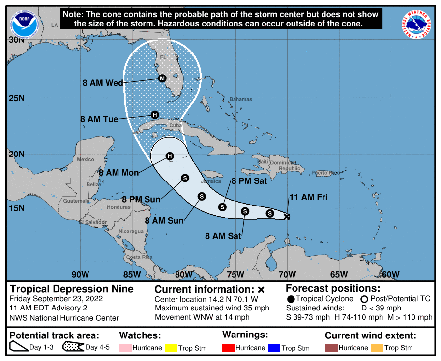
Here’s what we know now. Tropical Depression Nine developed early Friday morning in the east-central Caribbean, and as of the 11 a.m. NHC advisory has sustained winds of around 35 mph. The depression is moving a little north of west at around 15 mph, and a general westward track is likely through Saturday. Wind shear is displacing the depression’s deep convection west of the circulation center, which should keep strengthening gradual for the next 36 hours. Still, TD 9 may become a tropical storm at any time.
(Side note: as Tropical Depression 10 in the far eastern Atlantic has nabbed the name Hermine, Tropical Depression 9 will not be the second consecutive Hurricane Hermine in the Gulf, avoiding a ludicrous 2 Hermines, 2 furious scenario. The next name on the list is Ian.)
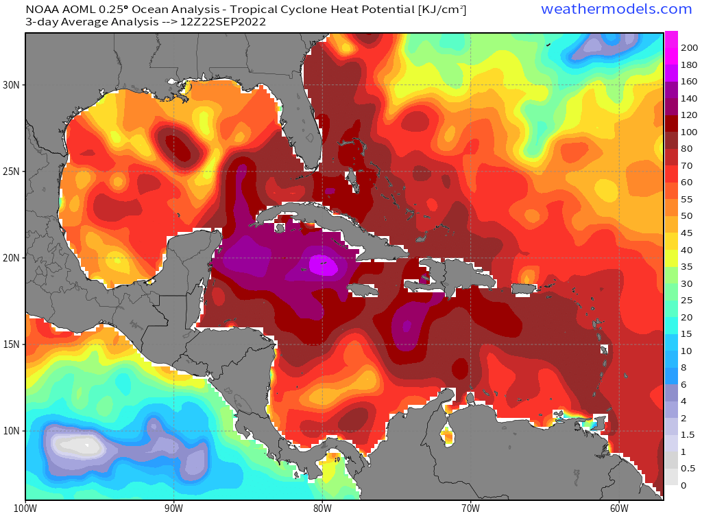
Sunday is when things start to get serious. TD 9 will be entering an environment in the western Caribbean in which upper-level outflow is excellent, mid-level moisture is abundant, and vertical wind shear is low. On top of that, the heat content of the northwestern Caribbean waters is the highest anywhere in the Atlantic basin. These factors are a perfect recipe for rapid intensification, which is defined as sustained winds jumping 30 knots or more in 24 hours.
The NHC intensity forecast is explicitly calling for rapid intensification Sunday into Monday, and TD 9 will likely be in favorable conditions for continued strengthening through Tuesday. The official forecast is for the storm to reach Category 3 strength by early Wednesday. That is a realistic base case, and I would caution that even faster strengthening is certainly possible between Sunday and Tuesday. It is exceptionally hard to predict how much strengthening will occur once rapid intensification is underway. History shows that major hurricanes can come together dizzyingly fast when the right ingredients are in place in the western Caribbean and southern Gulf.
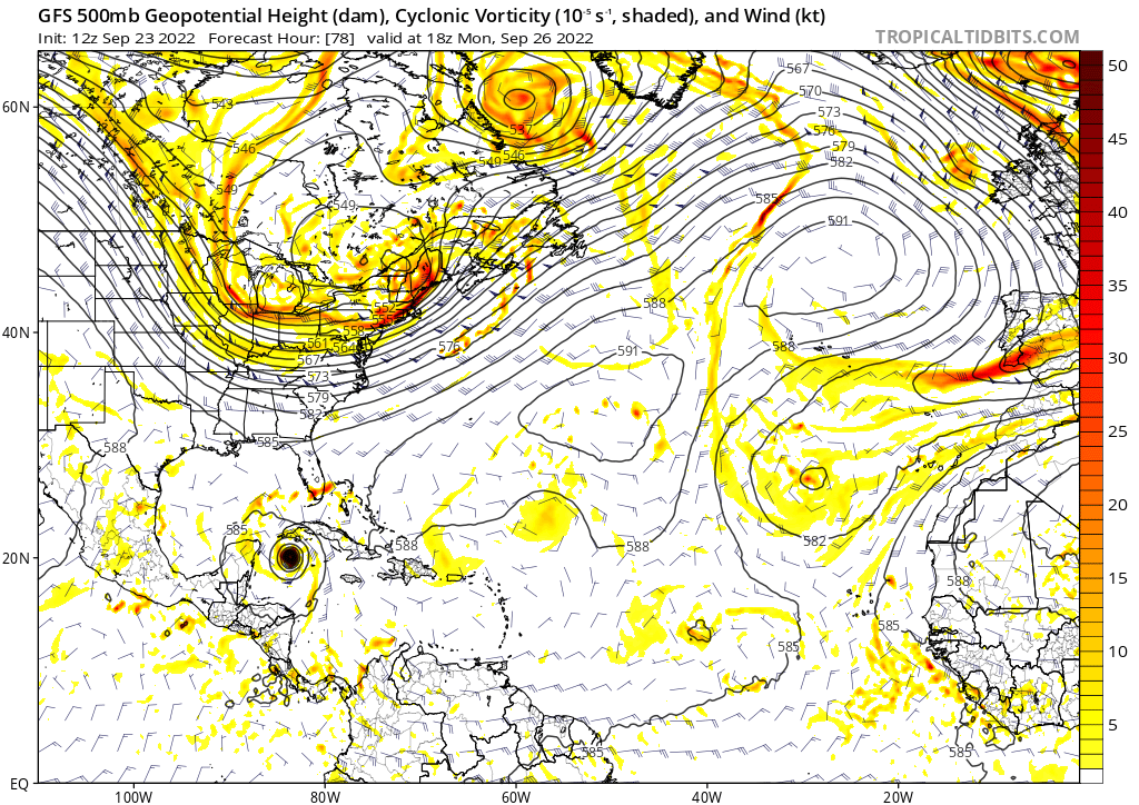
All forecast guidance suggests that TD 9’s track will gradually bend more northwestward on Sunday and Monday in response to a deep trough over the Eastern Seaboard, setting the storm on a path in the general direction of western Cuba by late Monday. Subtle differences in steering wind patterns will determine how far west TD 9 makes it before a more northward motion ensues on Tuesday. The most probable path will carry the storm into the eastern Gulf of Mexico, though a track further east into the Straits of Florida remains a possibility.
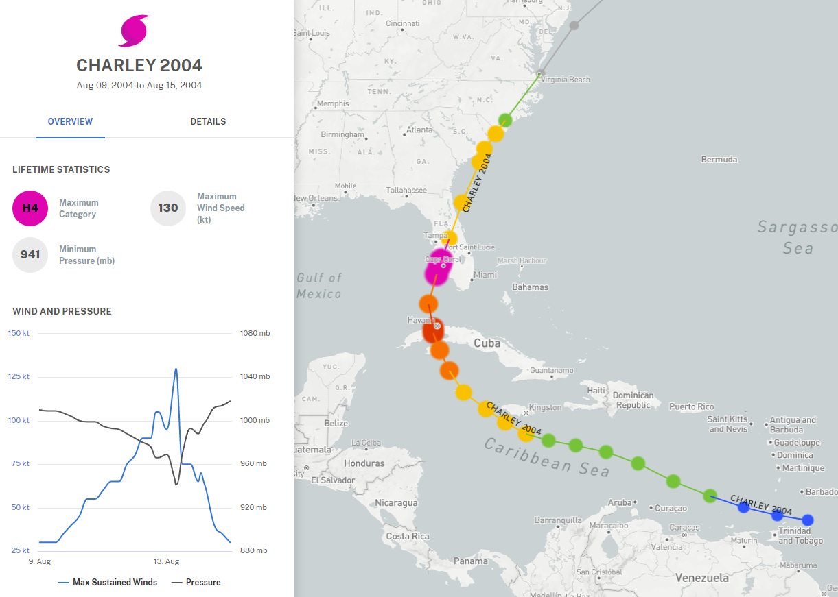
The forecast is uncertain beyond Tuesday. As of mid-day Friday, the official NHC track takes the storm close to Fort Myers on Wednesday morning as a major hurricane. This track is very similar to the one traced by Category 4 Hurricane Charley in August 2004, a sentence that will no doubt set everyone in Southwest and Central Florida on edge. This scenario, or one in which the turn north and northeast takes place even faster and puts the Keys and South Florida in the crosshairs on Tuesday, is probably the most dangerous scenario on the table. The combination of a short timeline for preparation, high population density, and the probable continuation of favorable conditions for strengthening through early Wednesday means that residents of the southern half of the Florida peninsula should begin preparing for a possible major hurricane now.
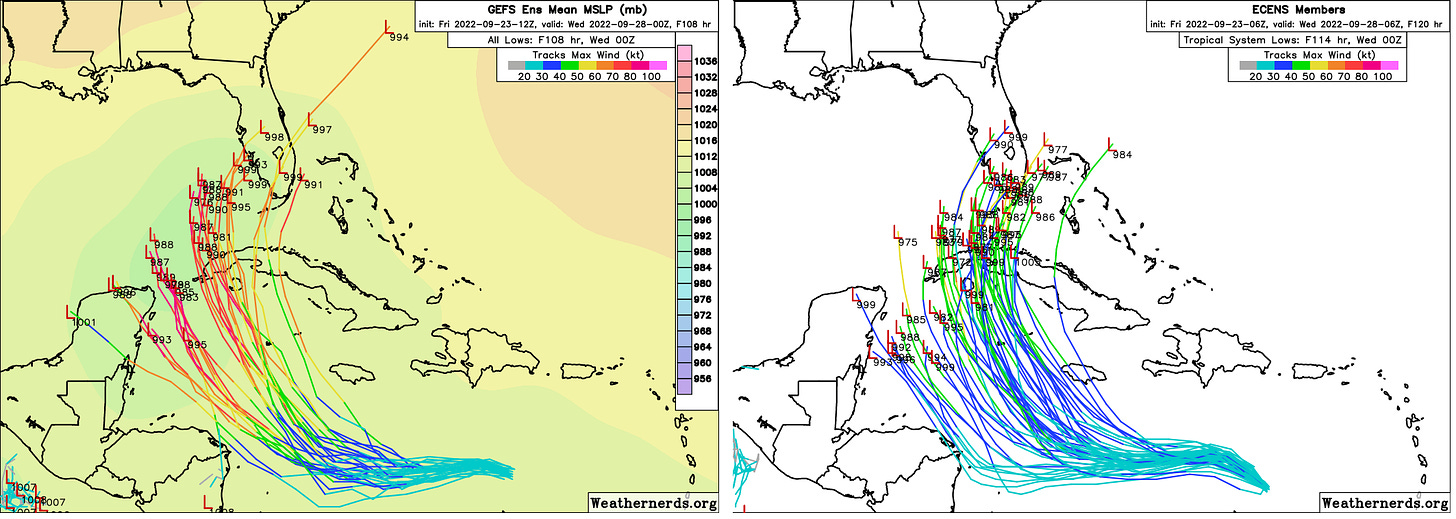
TD 9 could also swing farther west towards the Yucatan Channel before angling north and then north-northeast over the eastern Gulf. This scenario would increase the eventual risks for the Panhandle, Big Bend, and west Central Florida, and today’s model runs are edging back west after a sizeable jump east yesterday. While spending more time over the Gulf sounds like a bad deal, this could be offset by increasing shear and dry air intrusion into the storm beyond Wednesday. An additional complication is that the eastern U.S. trough will begin to depart in the middle of next week, causing steering currents in the eastern Gulf to weaken in 5-6 days and a period of slower or erratic motion to possibly ensue.
The bottom line is if TD 9 doesn’t sprint across South Florida or east-central Florida on Tuesday or Wednesday, which is possible, what might happen after that is unclear. Projecting a landfall point with this type of forecast track is impossible, as the narrow angle of approach between the storm’s motion and the orientation of the Florida Gulf coastline means small track deviations can have huge implications. During Hurricane Charley, a subtle shift in heading just prior to landfall brought the ferocious core of the storm into the Ft. Myers area, rather than Tampa Bay. Don’t focus on a forecast point: as of now, no one is off the hook in Florida.
There are many new Florida residents since the last serious hurricane threat, which I can tell because some of you are still using your turn signals. At this stage, know that this threat merits active preparation. In South Florida, you need to be putting your hurricane plans into action, including preparing to evacuate if an order is issued by your local authorities. In North Florida, get your hurricane plan and kit in order, and continue to monitor the situation. Hopefully Florida’s luck isn’t up this week, but if it is, preparation is essential. Keep watching the skies.
Next update: Tomorrow early afternoon.


