


Lee-gends of the Fall: Hurricane Watch Weekly Column for September 12th
As fake fall continues, Hurricane Lee will have weekend rain and wind impacts on New England, and drive heavy surf and beach erosion along Florida's East Coast.
This post is outdated. Click below for WeatherTiger’s Thursday (PM) Lee forecast:

WeatherTiger’s Hurricane Watch is a reader-supported publication. Paid subscribers get Florida-focused daily tropical briefings, plus weekly columns, full coverage of every hurricane threat, our exclusive real-time seasonal forecast model, and the ability to comment and ask questions for $49.99 per year.
Mid-September is a time of meteorological cognitive dissonance in the Southeast, as the ritual of fall is performed while high temperatures remain 93 degrees. Perhaps, the thinking goes, if we wear unnecessary scarves, patronize Spirit Halloween, and consume seasonal gourd coffees, autumn can be cargo-culted into existence.

Folks, don’t kid yourself. This is Florida. Your job is beach well into November. To be fair, high temperatures may pull back into the upper 80s this weekend, slightly decreasing the chances that wearing a scarf causes heat stroke. Nevertheless, our real season in September is not and will never be fall. The season is hurricane.

The second week of September is, in fact, the peak of hurricane season. Half of historical Atlantic activity and Florida hurricane landfalls have occurred prior to September 12th, and half remains ahead of us. This week alone is responsible for around one-eighth of total U.S. hurricane landfall activity since 1900, so getting through it un- or lightly scathed is a big deal, in and of itself.

Befitting the peak, the Atlantic is busy today, with two hurricanes churning and another storm likely to develop this week. However, the halftime report is optimistic, as the Gulf and Southeast Coasts are at no risk of landfall over the next 10 days. Rather, it is Florida’s cherished football squads bringing an I-formation blast of the Tropics with them as they venture into the nascent foliage of New England this weekend.
Hurricane Lee’s expected wind and rain impacts on the Northeast U.S. and Atlantic Canada are the focus, though Lee will also produce widespread heavy surf and rip currents along the entire U.S. East Coast this week. As of the NHC’s 2 p.m. Tuesday advisory, Lee is crawling west-northwest at a glacial 6 mph, and remains a Category 3 hurricane with maximum sustained winds of 115 mph.

While top winds are down from Lee’s Category 5 peak on Friday, successive eyewall replacement cycles and bouts with wind shear have resulted in a much larger hurricane than five days ago. Aircraft recon indicates Lee’s hurricane-force and tropical-storm-force winds have a diameter of more than 150 miles and 375 miles, respectively. With gales already covering an extent of open ocean greater than the distance between Jacksonville and Miami, be grateful Lee will pass over 700 miles east of Florida.
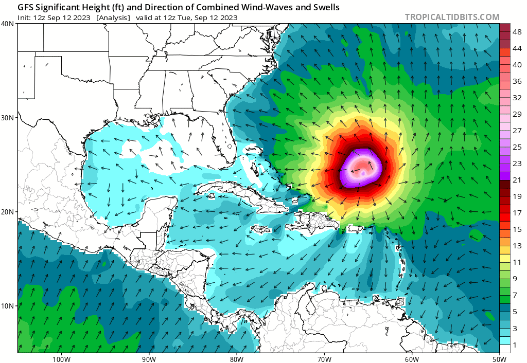
However, this massive windfield will expand further even as maximum winds decline, and that will drive heavy surf, rip current, and beach erosion impacts along the Florida East Coast north of Palm Beach between Wednesday and Sunday. Five days of near-shore seas of 5-10’ may cause particular issues in the sections of east-central and northeast Florida beaches badly depleted by Ian and Nicole. Unfortunately, rough surf and undertow from even distant hurricanes can be deadly; 2019’s Hurricane Lorenzo resulted in 8 U.S. deaths, despite remaining over 2,000 miles from the East Coast.
![[Image of probabilities of 34-kt winds]](https://substackcdn.com/image/fetch/f_auto,q_auto:good,fl_progressive:steep/https%3A%2F%2Fsubstack-post-media.s3.amazonaws.com%2Fpublic%2Fimages%2F08219d59-94d8-4e21-b963-98d1955e1fe1_897x738.png "[Image of probabilities of 34-kt winds]")
As anticipated, Lee is slowing down today and turning on its blinker as it prepares to turn right (just another reason it would not fit in in Florida), and by Friday morning all models agree than the hurricane will be accelerating north as it passes west of Bermuda. Lee will be crossing cooler waters churned up by Franklin and Idalia as it does, which should begin a gradual process of it becoming an even larger non-tropical cyclone as it makes a weekend approach to eastern New England or Atlantic Canada.
As Lee interacts with a front on Saturday, it will lose its inner core of hurricane-force winds, but tropical-storm-force winds and heavy rain are likely to extend across a Nor’easter-like 600-mile swath. Therefore, though Lee’s center is mostly likely to track over Maine or Nova Scotia on Sunday (probably after having lost residual tropical characteristics), hazardous wind, rain, and surge impacts are expected over a broad area including most of Atlantic Canada and eastern New England. Coastal gales are probable for Maine east, and possible in coastal Massachusetts Saturday and Sunday.

How far Lee’s heavy precip reaches into western New England is yet to be determined. In Boston, the ‘Noles may face driving rain and low-end tropical-storm-force gusts in Boston on Saturday if Lee tracks more towards Maine, or occasional showers and blustery winds with a path towards Nova Scotia. Either scenario is possible, though the eastern track is a bit more likely; either way, storm preparations should be underway in eastern New England. Rainfall may extend as far west as Vermont and western Connecticut if Lee tracks along the left edge of the ensemble envelope, but precip is unlikely to reach New York City. Flooding is also a realistic concern in eastern New England, as Lee will drop rains of 2-4” or more on saturated soils.

Elsewhere in the Tropics, Category 1 Hurricane Margot is meandering the open waters of the eastern subtropical Atlantic, and will continue to do so without bothering anyone for another five days before Mar-going away. Conditions also look favorable for another tropical storm to develop between West Africa and the Lesser Antilles by Saturday, but troughing over the western Atlantic should keep anything that develops east of the continental U.S. as well. No other tropical threats are on the horizon.

In conclusion, rather than attempting to manifest fall with The Secret-level magical thinking, I recommend Floridians focus their psychic energies on keeping this protective trough in place, a goal both practical and achievable. If we can make it another two weeks without incident, the historical rate of hurricanes approaching Florida from the east declines dramatically in late September. That leaves October to negotiate; I’ll be back next week with a look at what we might expect of the final third of hurricane season. Until then, don’t forget to ice your pumpkin spice, and keep watching the skies.
In other news: this evening at 7 pm, I will be presenting a webinar on WeatherTiger’s expectations for the rest of hurricane season via the American Meteorological Society. Registration is free and the link is below:

https://us06web.zoom.us/webinar/register/6316940222215/WN_yhHWMnmZR5uajTGJuLX3Aw#/registration
Hope to see you there! Originally I was supposed to do this on the evening of August 29th, but I turned out to be a little preoccupied that night.


Question: Given the size and duration of Lee, does that in effect cool however slightly a vast patch of the Western Atlantic thus resulting in cooler waters leading up to Florida and by implication lessening, however little, the potential for hurricanes for the remainder of the season?