WeatherTiger's Hurricane Idalia Landfall Live Blog [Final Post: 11:30 a.m.]
Tracking Idalia moment-by-moment through landfall and beyond.
WeatherTiger’s Hurricane Idalia landfall liveblog has concluded. Thanks for reading, and hope you stayed safe.
For complete Florida storm coverage, sign up for WeatherTiger’s hurricane forecast newsletter by clicking here:
A new daily (8/31) blog for paid supporters discussing Idalia, Franklin, Jose, and 3 regions of possible tropical development is available exclusively for subscribers here.
11:30a: NHC 11 a.m. advisory and wrapping up
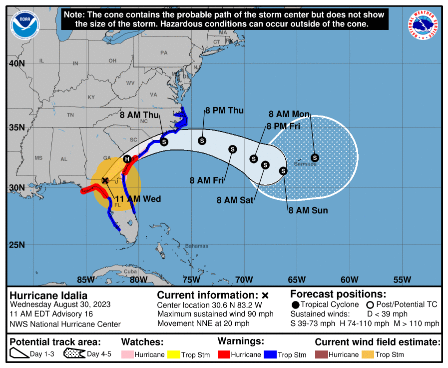
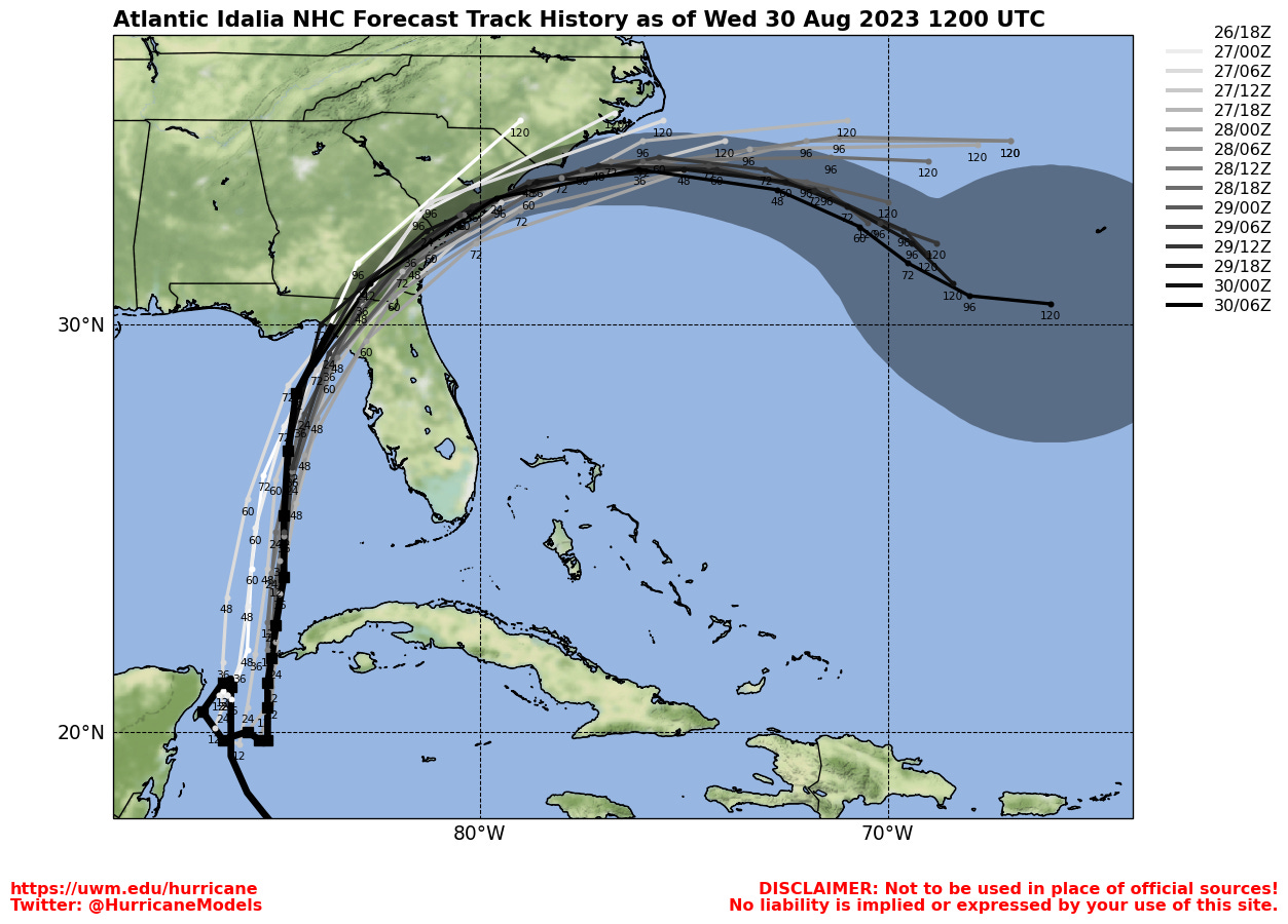
The NHC 11 a.m. advisory package finds Idalia centered on the Florida-Georgia line about 15 miles SSE of Valdosta, accelerating north-northeast at 20 mph. Maximum winds are down to 90 mph. Going forward, Idalia will move even faster northeast through south Georgia and the coastal Carolinas today, then punch into the open Atlantic tomorrow. Shear and dry air will have done a number on it by then, and it should drift generally east and out-to-sea thereafter. Some GFS forecasts in the last couple of days suggested that Idalia might loop back west towards Florida next week, but this idea has been dropped in the more recent runs. I think we’ve all had enough of the GFS’ zany ideas this week.
With rainfall gradually waning over the Panhandle over the next few hours, I’m going to wrap this morning’s live blog with that. Idalia kept North Florida guessing right down to the wire, but ultimately hewed closely to the exceptionally consistent NHC forecasts for a landfall in eastern Apalachee Bay. While Idalia was a devastating surge event for eastern Apalachee Bay and the Nature Coast and its eyewall winds have left a trail of destruction across the Big Bend, Tallahassee escaped with what I would characterize as light punishment with wind gusts mostly in the 50-60 mph range, potentially higher locally. I clocked 28 miles from WeatherTiger World HQ in southeastern Tallahassee to the western edge of the eyewall, so count your blessings, Leon County.
Thank you for reading, stay safe, Florida, and keep watching the skies.
10:55a: Winding down
With Idalia’s center entering Georgia, significant precip is wrapping up in the Panhandle with the exception of two narrow but potent bands— one over northern and eastern Leon County, and the other over northern Jefferson County. While winds are slowly falling across the region, Apalachee Regional Park just clocked a 55 mph gust under this band, so your mileage may vary.
10:35a: Historical context, part 2
With the initial assessment that Idalia made landfall south of Perry as a Category 3 hurricane, it becomes the 42nd major hurricane to make landfall in Florida since 1851. This is the first major hurricane to ever make landfall between Panama City and Cedar Key.
10:20a: The back side of water
As drier air works its way around the western and southern portions of Idalia’s circulation, precipitation is ending now in western Apalachee Bay and the Nature Coast. Periodic bands of showers will continue into the afternoon in northeast and central Florida.
In the eastern Panhandle, a heavier band of showers continued to hold serve and bring gusts in the 40-50 mph range. This should wane within the next hour from south to north across Leon county, with breezy conditions and only isolated showers for the rest of the day in Tallahassee. Almost done.
10:05a: NHC update
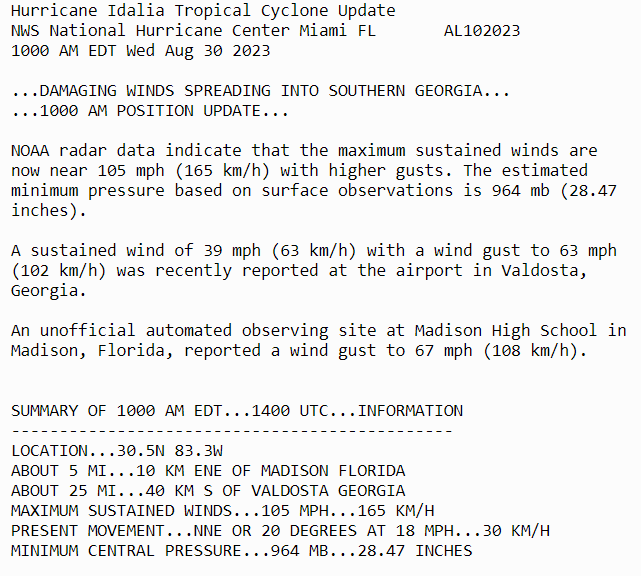
The NHC 10 a.m. hourly update find the center of Idalia is now very close to Madison, and highlights that the worst of the impacts are advancing into Georgia, where a flash flood warning is now in effect for Valdosta.
With Florida impacts starting to wane as the focus shifts north in the next hour, I will plan on wrapping the liveblog with the NHC 11 a.m. full advisory package. For now, 45-55 mph gusts and heavy rain are hanging on for a little while longer in Tallahassee.
9:50a: Still bubbling
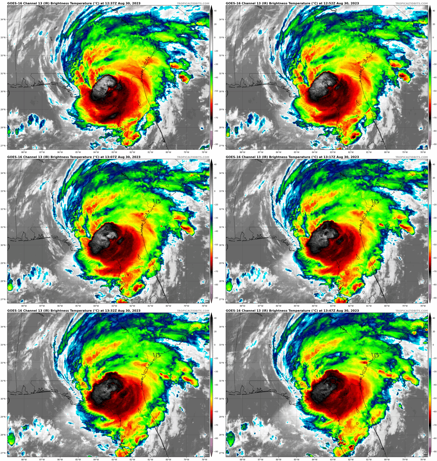
More than two hours after landfall, Idalia is still generating an impressive amount of very deep convection near its circulation center. However, cut off from its source of heat energy and with wind shear increasing, that deep convection is looking much less organized and more ragged than early this morning.
9:40a: Wind gust map
A selection of peak wind gust observations so far across the Big Bend. This map is somewhat limited, as it only includes stations still reporting; also, the Taylor and Dixie County coasts have few or no observation stations to begin with.
9:30a: Heading for Georgia
As of 9:30 a.m., the center of still-Category 2 Hurricane Idalia is located over southern Madison County, but starting to lose some definition as dry air works into the southern half of the eyewall. Central and Northern Madison County are still getting walloped, and Valdosta is next in line coming up next hour.
Further west, that stubborn stationary band of heavy rain and gusty wind continues to affect central and eastern Leon County. Of course, compared to the potential for a direct hit from the core of a major hurricane we were contemplating yesterday in Tallahassee, we’ll take it. The FAMU WeatherSTEM unit atop the highest of Tallahassee’s 7 hills has taken over the wind gust lead for Leon County at 54 mph.
9:15a: Double warnings in Madison Co.
In addition to an ongoing Extreme Wind Warning in Madison County, the extreme rain rates of 2”+ per hour associated with the eyewall of Idalia has triggered a Flash Flood Warning for Madison and portions of northern Taylor Counties good through noon.
If you’re in the region outlined in green, now you have two good reasons to shelter in place. Separately, I-10 is reported blocked by downed trees east of U.S. 19 in Jefferson County.
9:05a: NHC update
The 9 a.m. update from the NHC finds Idalia 20 miles south-southwest of Madison, moving north-northeast at 18 mph, and with maximum sustained winds now down to 110 mph (Category 2). Plenty of major wind and surge impacts still rolling, as they note.
Locally in Leon County, there have been a number of recent wind gusts of 50 to 55 mph in the past half hour, including a 53 mph gust in Killearn.
8:55a: Wind map
As a helpful, if rough aid in understanding the distribution of winds in Idalia, this is the 8:30 a.m. wind gust analysis from the National Weather Service’s Real Time Mesoscale Analysis.
Areas in brown and gray are those seeing 75-100+ mph gusts, oranges and reds are tropical-storm-force gusts. So far, Tallahassee airport has peaked out at 30 mph sustained with a 46 mph top gust as of just a moment ago. Still kicking and will be for at least another hour in Leon County, maybe two.
8:45a: Rain piling up
With an arc of nearly stationary heavy rainfall across eastern Leon, Jefferson, and Wakulla Counties, rainfall totals are starting to stack up. Just since midnight, many stations in the WeatherSTEM network across the Big Bend have seen anywhere from 2-5” of rainfall so far. I can confirm these totals in eastern Leon County, where the WeatherTiger World HQ station is reporting 2.59” so far today
These totals are in good agreement with the NHC rainfall assessments issued late yesterday, and localized flash flooding or river flooding may become an issue if these heavy rains remain in place for several more hours. Remember not to drive through flooded roads, or better yet, just don’t drive anywhere until the afternoon.
8:30a: On the move
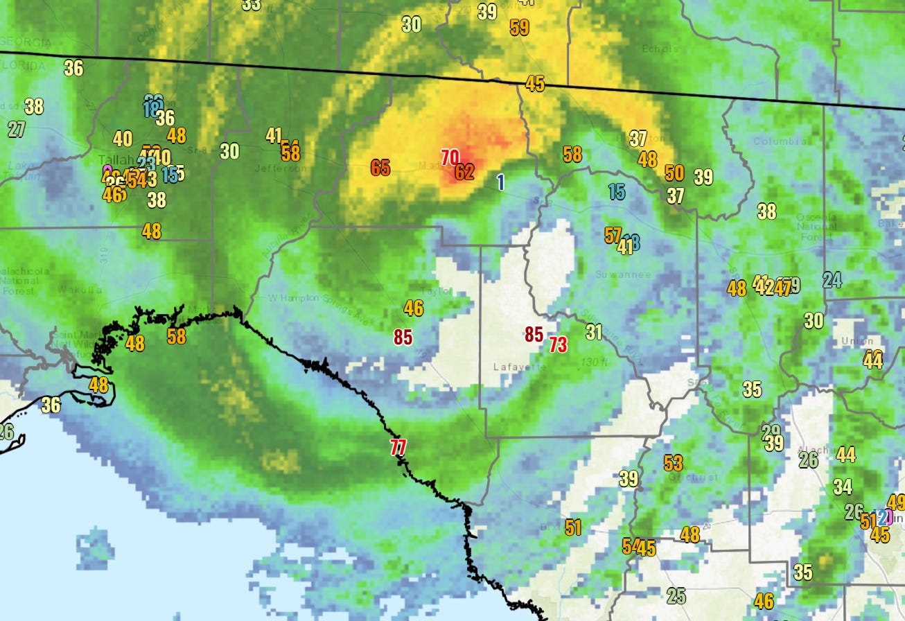
The northwestern quadrant of the eyewall is continuing to hammer Perry and north-central Taylor County. Perry Airport reported a top gust of 85 mph and a sustained wind of 62 mph at 8:15, and could easily be seeing worse now. Eyewall lightning is also occurring in Taylor and Lafayette Counties.
This core of destructive inland winds is still moving rapidly north-northeast, necessitating another Extreme Wind Warning for the potential of 110 mph+ wind gusts in central and eastern Madison County and Suwannee County, including Madison and Live Oak. Seek interior shelter immediately in these areas.
Outside of this core eyewall, wind gusts over the next 1-2 hours in North Central Florida and the eastern Panhandle will range from 45 to 60 mph. A large band moving into the Jacksonville area is kicking off tropical-storm-force gusts of 40-50 mph, and similar gusts will periodically continue there into the noon hour.
8:15a: Surge check
While the windspeeds are beginning to slowly subside in Dixie and Levy Counties, the catastrophic surge impacts along the Nature Coast and eastern Apalachee Bay continue to mount. Onshore winds will keep piling up water into the early afternoon in those areas, particularly as low tide is passing now and a very high high tide is set for around 1-2pm. As of 8:15am, real-time surge in Cedar Key is nearly 10’ and still rising steeply.
While observations are sparse, surge will likely turn out in general alignment with this model run from the 5 a.m. NHC forecast track: devastating for the northern Nature Coast and eastern Apalachee Bay, more manageable and localized in central and western Apalachee Bay.
8:05a: Eyewall moving inland
As Idalia’s eyewall plows north-northeast across inland Taylor County, Perry is in the heart of the inner eyewall at the top of the hour. Conditions should improve in Taylor County from southwest to northeast starting in about half an hour along the coast as the eyewall clears.
In Leon and Wakulla Counties, there has been the usual uptick in inland winds once the center of circulation is ashore. While Tallahassee, Monticello, and Crawfordville thankfully did not get the inner core of Idalia, an outer and weaker wind max is setting up over the area. Expect the worst conditions in Leon, Jefferson, and inland Wakulla County with periodic gusts in the 50-60 mph range through 10 a.m.
7:50a: Landfall.
The sun has risen on Hurricane Idalia as it officially makes landfall in Keaton Beach, FL, as a Category 3 hurricane with 125 mph sustained winds.
This is the first recorded landfall of a Category 3 or above hurricane in Apalachee Bay.
7:45a: More wind
With landfall imminent, there is more clarity in what peak wind gusts will be across the eastern Panhandle and Big Bend.
Look for hurricane-force wind gusts exceeding 110 mph to accompany landfall in Taylor and Dixie Counties, and these extreme winds to potentially spread inland over the next hour and the eyewall moves northeast. A new Extreme Wind Warning has just been issued by the National Weather Service for northern Taylor, Lafayette, and western Dixie Counties for this threat. Shelter time in these areas.
Outside of the eyewall, a broad area of peak wind gusts between 50 and 60 mph is likely through the mid-morning hours across much of the eastern Panhandle, including Tallahassee. NWS is projecting a peak gust of between 55 and 60 mph in Tallahassee, which would roughly slot Idalia in between Irma (55 mph) and Hermine (64 mph) and below Michael (lower 70s) and Kate (lower/mid 80s) in the echelons of Tallahassee windstorms.
7:25a: Landfall Nears
Per radar imagery, Idalia’s center of circulation is less than 10 miles offshore tiny Dekle Beach in east-central Taylor County (and 60 miles southeast of Tallahassee). With a little bit of a shift to the east in the past hour, this motion is likely to bring Idalia onshore sometime around 8 a.m.
With the hurricane tracking at a 25 degree heading at about 18 mph, the next places in line for the potential of major-hurricane-force wind gusts associated with Idalia’s inner core, at least in gusts, are Mayo and Perry. Madison is also in the firing line another hour down the road.
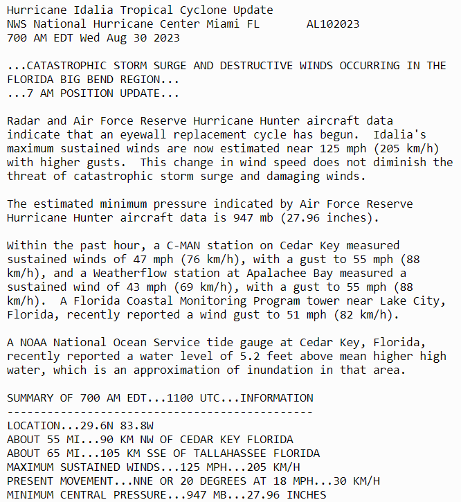
7:10a: Back to Cat 3, but not a “downgrade“
The 7 a.m. hourly update on Idalia from the NHC has is inching ever-closer to land, with maximum sustained winds down a hair to 125 mph. Here’s the update:
The key here is to not think of the slight reduction in maximum winds as weakening. When an eyewall replacement cycle occurs, it usually resulting in broadening the swath of tropical-storm and hurricane-force winds. The threats posed by Idalia are unchanged, as the NHC emphasizes. To underscore that point, storm surge has now risen to 7.5’ in Cedar Key, still climbing rapidly.
7:00a: Historical context
Speaking of Michael and Ian, if you’re new to Florida you might be forgiving for thinking that Category 4 and 5 hurricanes hit almost every year. This would be #4 since 2017, for those counting at home.
Historically, that isn’t the case. Only 16 Category 4 or 5 hurricanes have made landfall in Florida since 1900; should Idalia be unlucky #17, it will join Michael as the only Cat 4/5s to make landfall in Florida north of Charlotte Harbor.
6:50a: Zooming out
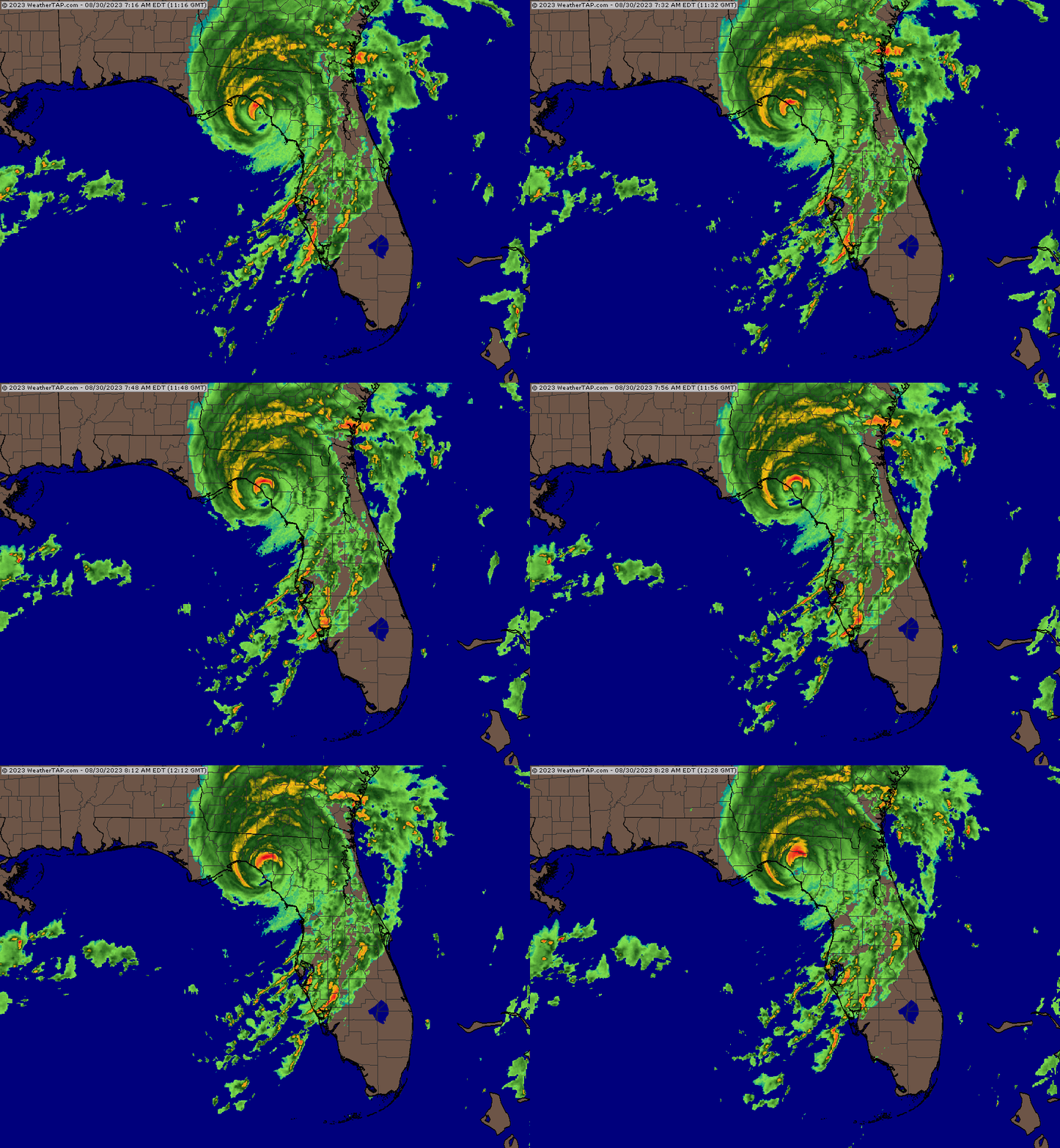
We’ve been looking closely at the granular impacts of Hurricane Idalia over the past hour, so let’s take a step back and see what this Category 4 storm looks like from space as it approaches landfall.
Not surprisingly, it’s a monster.
6:35a: Winds picking up
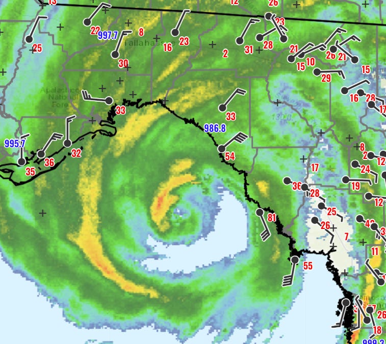
As the core of Category 4 Hurricane Idalia prepares to push onshore, tropical-storm-force gusts are overspreading broad sections of the Apalachee Bay coastline.
Top gusts so far across inland North Florida are mostly in the 30-40 mph range, with 40-50 mph gusts along the western Apalachee Bay coast. In eastern Apalachee Bay, hurricane-force winds are now moving ashore; a FSWN station in Horseshoe Beach, Dixie County notched a gust of 81 mph at 6:10 a.m.
6:20a: Extreme Wind Warning issued
With the eastern eyewall of Hurricane Idalia approaching Taylor County, the NWS has issued a rare Extreme Wind Warning for portions of Taylor and Dixie Counties until 9:15 a.m. The areas covered by those Warnings are shown here:
The National Weather Service issues Extreme Wind Warnings for the areas directly impacted by the eyewall and likely to see wind gusts at or above 115 mph. You need to treat these as you would a Tornado Warning. If you are under an Extreme Wind Warning, go immediately to a windowless, interior room in a sound structure and shelter there. You may also want to consider putting a helmet on yourself or your kids, especially if you are in a building surrounded by tall trees.
6:10a: Good news on surge for some
The other aspect of the surge story worth noting this morning for those anxiously eyeing Idalia from the western half of Apalachee Bay: due to the path of the center of the storm towards Taylor County, this areas will see much more muted surge than eastern Apalachee Bay due to offshore or along-shore wind during the peak of the storm.
For example, current water levels in Apalachicola are only running about 1.5’ above normal. A little more surge than that is probable in the western Bay, but it won’t be the catastrophic surge that would have accompanied a track into Franklin or Wakulla Counties.
6:00a: Current conditions: surge
The worst of the storm surge is still ahead in Apalachee Bay, rising quickly on the Nature Coast, and pushing towards its peak along the west-central Florida coastline.
In Cedar Key, where the NHC surge expectation exceeds 10’ above high tide, they are well on their way there, at about 5.5’ of surge through the 6 a.m. hour.
As predicted, there is also significant surge well east of the center of the storm in Tampa Bay. Most stations in the Bay region are peaking now at around 5’ of surge, closely in line with the NHC forecast. This is causing plenty of roadway flooding, so stay off the roads this morning.
You can follow the latest water levels along the Florida Gulf Coast in real-time here.
5:45a: Current conditions: precipitation
As shown on Tallahassee radar, the most intense portion of Idalia, the inner eyewall, remains about 30 miles offshore Taylor County and about 40 miles south-southeast of coastal Wakulla County. Note also that the center of circulation is now east of Tallahassee’s longitude, taking the worst-case scenarios of a direct hit off the table for Leon County.
Steady rainfall has overspread the eastern Panhandle and Big Bend overnight, with about 0.25” of rain falling in Tallahassee in the last hour and heavier precip is on the way. Stronger bands are also currently raking the Nature Coast with high winds and torrential rain. Persistent rain is likely to continue in the eastern Panhandle through roughly noon, bringing storm total rainfall of 4-8”.
Next up: a look at where surge is rising.
5:30a: Where to?
The question on everyone in North Florida’s mind as you rouse from a night of anxiety is: where is the eyewall of Hurricane Idalia going to come ashore?
Thanks to radar and reconnaissance aircraft sweeping the storm, we have a pretty good idea of the answer now. Over the last few hours, Idalia has been moving at a heading of about 20-25 degrees, or east of north. On this track, and potentially factoring in a little more angling to the east Idalia will be ashore somewhere south of Perry in central Taylor County between 8 and 9 a.m.
Much more on what this means for impacts in upcoming posts.
5:05a: Welcome and Overview
Welcome to WeatherTiger’s Hurricane Idalia landfall live blog. If you’ve never read WeatherTiger’s Hurricane Watch prior to today, I’m Ryan Truchelut, Chief Meteorologist at WeatherTiger, a Tallahassee-based weather consulting and forecasting company. In addition to my professional forecasting experience, I’ve been researching hurricanes for over 15 years and graduated from FSU’s doctoral meteorology program. I also went through the eye of Hurricane Charley. I’ve been preparing for days like this my entire life.
Over the next 6 hours or so, I’ll be frequently updating this page with my insights on minute-by-minute developments with Hurricane Idalia: the latest NHC advisories, National Weather Service warnings, local weather observations, and my forecasting insights on all aspects of this catastrophic storm. My goal is to keep you safe by providing accurate, no-hype, real-time information until Idalia has moved out of Florida. I did this last year with Hurricane Ian, and am back at it with yet another I-storm. It's always the I-storms, and it's always Wednesdays.
If you’re just getting caught up on Hurricane Idalia, well, it’s been busy through the overnight hours. Per the NHC's 5 a.m. advisory, Idalia has strengthened to a Category 4 hurricane, and maximum sustained winds are now estimated at 130 mph. Idalia is still strengthening and could intensify more before landfall, which is likely in Taylor County in another 3 hours or so.
Massive surge, wind, and rain impacts are spreading across North Florida and west-central Florida, and you should be sheltering in place in these areas into the afternoon. I’ll dig into all these threats and more in subsequent posts. Let's get through this together.












![[Image of WPC QPF U.S. rainfall potential] [Image of WPC QPF U.S. rainfall potential]](https://substackcdn.com/image/fetch/w_1456,c_limit,f_auto,q_auto:good,fl_lossy/https%3A%2F%2Fsubstack-post-media.s3.amazonaws.com%2Fpublic%2Fimages%2F258e7fa5-db8b-4e80-af74-59249cf99f41_892x716.gif)


Excellent work, Doc! Your insights and updates the last several days were invaluable. Fortunate to have discovered your channel. Patting myself on the back on the decision to subscribe. 😀
Your live blog was a resource of confidence in what was happening. I refreshed frequently to get the most recent update in real time. From pulling the "fire alarm" to landfall, your work, Ryan, was exceptional. Thank you!