WeatherTiger's Hurricane Watch for October 21st
Surprising Oscar meanders near the eastern tip of Cuba, but is not a U.S. threat.
Florida and continental U.S. tropical threat synopsis: No tropical threats to Florida or the continental U.S. for at least the next 7 days.
Almanac: It’s Monday, October 21st… day 142 of the 2024 hurricane season, 41 days to go. By total storm energy, the season is 90.1%, 96.2%, and 94% complete for the Atlantic, continental U.S., and Florida, respectively.
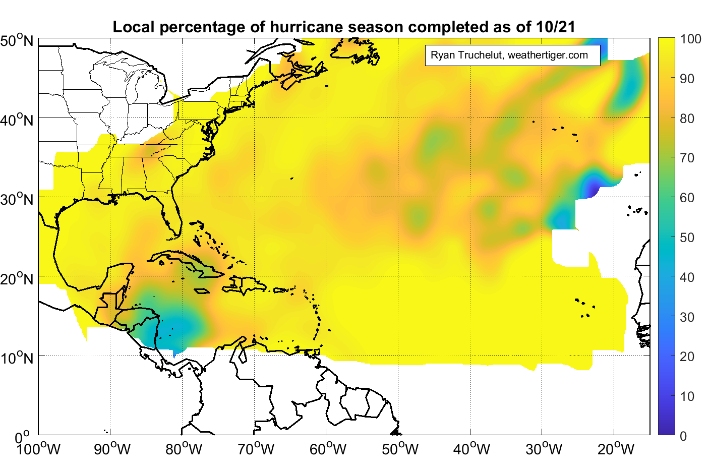
In total, only about 10% of Accumulated Cyclone Energy in the Atlantic, Caribbean, and Gulf occurs on or after October 21st. However, most locations in the Atlantic Basin are actually 95%+ done with hurricane season (shown in gold, above); the major exception to that is a portion of the western Caribbean near Honduras and Nicaragua, where up to half of historical hurricane activity actually happens after 10/21 (in green).
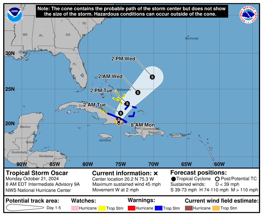
Active storms: Tropical Storm Oscar is drifting over mountainous eastern Cuba this morning, with maximum sustained winds estimated at around 40 mph. Diminutive Oscar seems to be moving little today, but a more definitive track to the northeast should develop in the next 12 to 24 hours as Oscar gets picked up by, then eventually merges with an upper low to its north. Tropical Storm Watches and Warnings are in effect for the central and eastern Bahamas, but Oscar remains no threat to Florida.
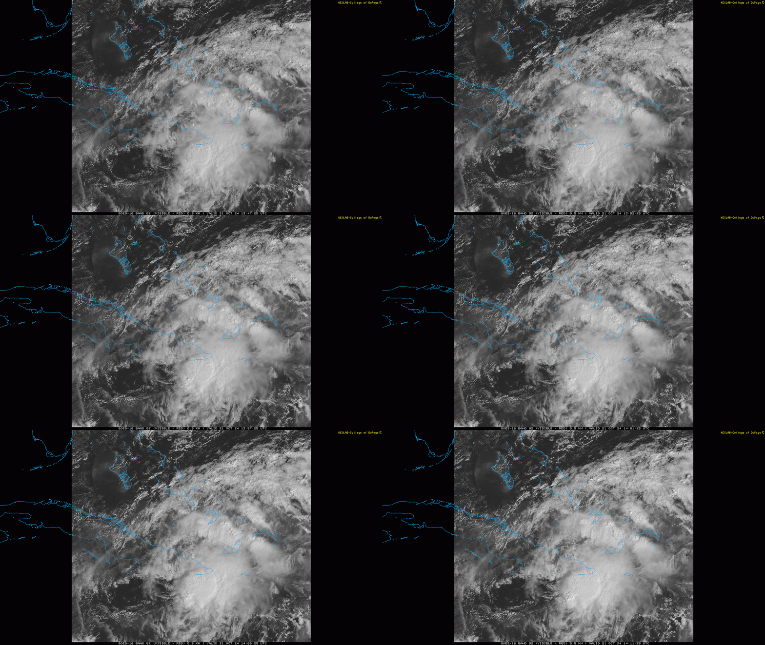
While there is no change to the U.S. forecast, Oscar has been a surprising little storm for many reasons. First, Oscar developed very quickly on Saturday morning, with reconnaissance aircraft confirming a tiny hurricane had developed just a couple of hours after the NHC initiated advisories on Tropical Storm Oscar. Additionally, per retired NHC forecaster James Franklin, Oscar’s radius of maximum winds of just five nautical miles outward from its pinhole eye makes it one of the smallest, if not the smallest hurricane ever on record in the Atlantic.
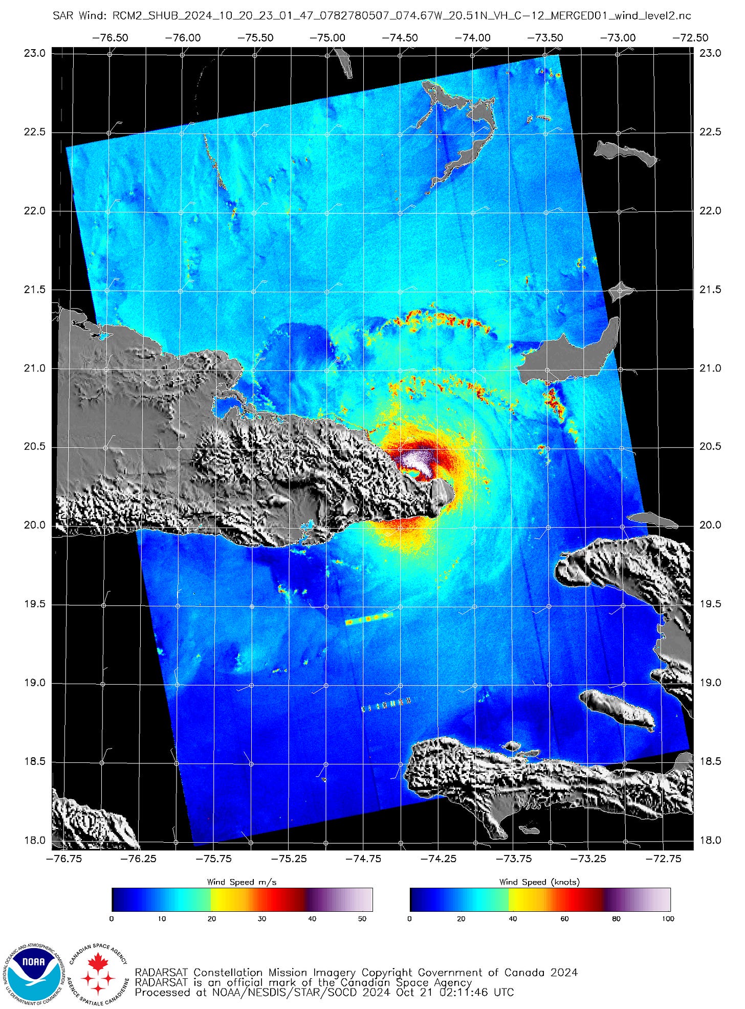
Because Oscar was scarcely bigger than a single thunderstorm complex, models and genesis forecasts whiffed on it in a way that is quite rare in the 21st Century. That’s not an academic concern, either, as Oscar also made landfall on Saturday evening in eastern Cuba as a hurricane. NHC estimated sustained winds at landfall of 80 mph, though a satellite-based platform hinted that winds in Oscar’s core may have been at least Category 2 intensity at landfall. Oscar is a case meriting further study in the off-season, as we need to figure out how to avoid similar surprises near land in the future.
Disturbances in the NHC tropical weather outlook: None.
Elsewhere: Spicy weekend in the Tropics. Not only did Oscar make its move, but PTC 15, as predicted, briefly became Tropical Storm Nadine before moving westward into Belize on Saturday, spreading significant rainfall across Central America as it did.
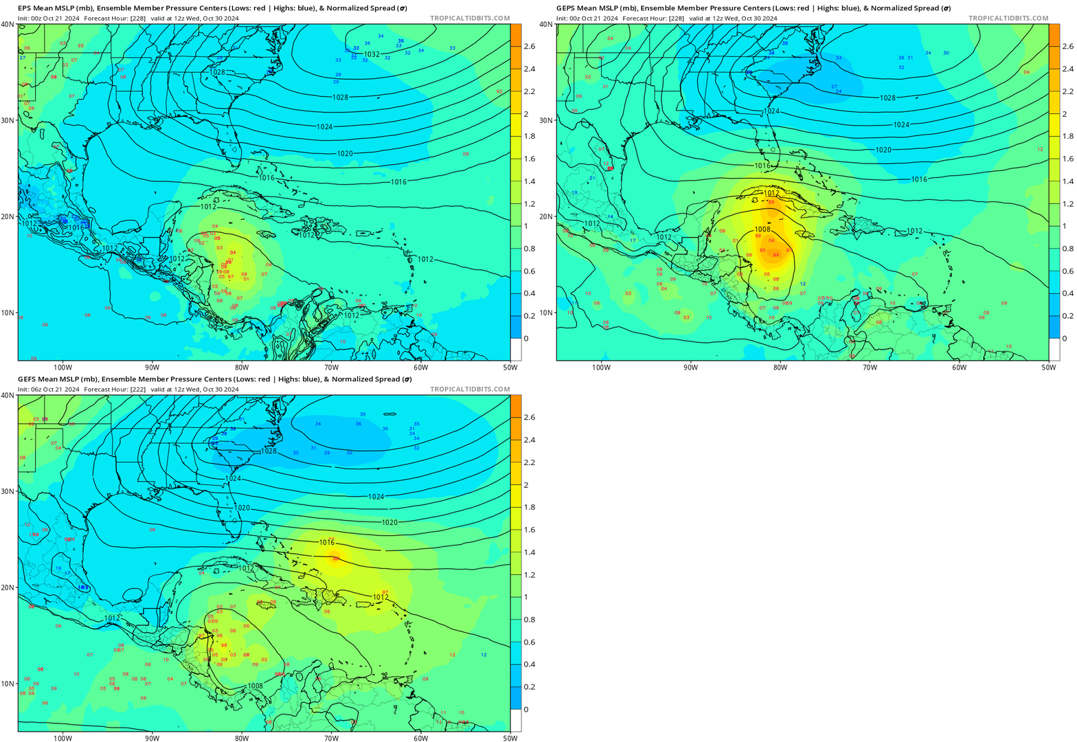
Interestingly and perhaps a bit alarmingly, that mini-burst of activity happened without support from large-scale upper-level wind patterns, as the MJO remains in unfavorable phases for Atlantic tropical activity for about another week. Models are in very good agreement on the MJO entering more supportive phases for Caribbean convection in the last few days of October, when long-range ensembles are lighting up with the prospect of potential tropical development right in that climatological sweet spot east of Nicaragua. With a tropical wave moving into the western Caribbean around then, development is quite plausible in the general 8-10 day timeframe. As previously indicated, this region is something to keep an eye on at the tail end of October and early in November.
Next update: Next subscriber update tomorrow morning.
https://www.dropbox.com/scl/fi/3ra6r5wb24q7gjsfit7j1/WeatherTiger_TUMC_final.pptx?rlkey=10i7uqakhnprklh1316lademo&st=1hlhh58n&dl=0


