WeatherTiger Tropical Storm Milton Update for October 5th (PM)
The threat to the Florida peninsula from newly formed Tropical Storm Milton has increased notably since yesterday. Time to react.
This forecast is outdated! Click the link below for the latest information.
This update has been sent to all subscribers. You may share it freely.
A quick and unscheduled Saturday update to bring you up to speed on today’s developments in the Gulf of Mexico, as the disturbance I’ve been monitoring all week has escalated quickly, becoming Tropical Storm Milton this afternoon.
If you read yesterday afternoon’s forecast, you’ll recall that I was targeting Monday for the development of a depression, so this is a big jump forward in time. An intense convective burst has been occurring for the last 24 hours in the southwestern Gulf in association with vorticity originating in the eastern Pacific, which has spurred the rapid redevelopment of a surface circulation. That’s not something models or observations were suggesting would occur; as recently as Friday afternoon, the NHC had a 0% chance of development in the next 48 hours on this. In general, tropical meteorologists are a little shocked about what’s happened with Milton. As likely are you, understandably so.
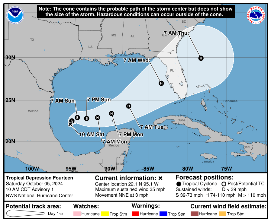
But life comes at you fast, so here we go again. The initial NHC advisory package issued at 11 a.m. Saturday takes Milton generally east for the next couple of days, brings it to hurricane strength by Monday, and then has it transit Central Florida on Wednesday as a strong Category 2, accelerating east-northeast. Florida Gulf Coast hurricane landfalls are common in October, but don’t usually cross all the way from the western Gulf to do so; historically, the only matches to Milton’s general track are east-northeast-bound hurricanes striking west-central Florida in 1859 and 1888.
Yesterday’s piece laid out a more comprehensive narrative of the environment around Milton and its likely impacts. Despite the rapid organizational trends, many things haven’t shifted much from that forecast, while other key considerations have changed dramatically. Let’s take a look at what Milton’s formation changes, and what it doesn’t:
Not changed: Impacts outside of Florida and in the Panhandle. There are no significant impacts expected outside of the Florida peninsula with Milton. The Panhandle will remain protected by a cold front and is not at risk of seeing a landfall, and no moisture from the storm will reach into the Appalachians.
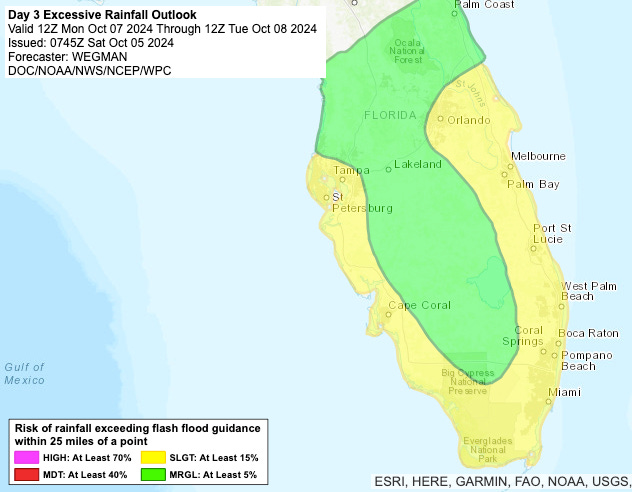
Not changed: The peninsula rain threat. I’ve been highlighting the significant risks of excessive rainfall to South and Central Florida for the past week, as these were likely no matter what form the low took. Milton developing early sharpens these risks a bit and stretches them further north into the eastern Big Bend or even northeast Florida. But overall, the entire peninsula is likely to see 5-10” rains in the next week, with an associated risk of flash flooding in low-lying or poorly drained areas.
Not changed: General track of system and timing of impacts. Early development doesn’t change the fact that the steering current winds across the Gulf this week will be mostly out of the west, blowing to the east. That accounts for Milton’s extremely unusual path to Florida, and why landfall is still expected to be somewhere between the southern Nature Coast and Marco Island midweek, only nudging a little north since yesterday. Intermittent heavy rain starts up tomorrow in the peninsula, and the worst weather will arrive around Wednesday.
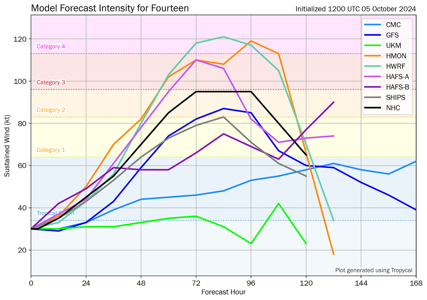
Changed: Intensity forecast. One reason I was more conservative in how strong I thought the storm might get yesterday is because wind shear is likely to pick up by Wednesday as Milton crosses the eastern Gulf and approaches Florida. That’s still true, but conditions are unfortunately quite favorable for strengthening over the next three days: low wind shear, plenty of moisture, and excessive heat content in the Gulf water. Some of the global and hurricane models are bringing Milton to major hurricane intensity by Tuesday, and given its quick development in the more sheltered southern Gulf, that sadly looks like a very realistic possibility now. Time plus Gulf, never a good thing.
With Milton potentially at or pushing major hurricane intensity by Tuesday, it will have the ability to modify its local upper-level environment somewhat, via all the air rising up through and then spreading out away from the storm. That outflow won’t stop the shear entirely, but it may deflect enough of it to prevent much or any weakening from happening on approach to landfall. The NHC intensity forecast plateaus maximum winds at 110 mph from Tuesday into Wednesday for this reason. Again, realistically, Milton could well be a category 3+ on final approach midweek. The key is the next couple of days, so hope for less short-term organization: a weaker storm won’t be able to push unfavorable shearing winds out of its way in the midweek as effectively, and that could result in a Category 1 or weaker 2 at landfall. That is still a realistic possibility, even if it feels like it’s always the worst-case scenarios that actually play out.

Changed: Wind and surge threats. While coastal flooding may well have been an issue even with a weaker, broader storm, a dramatic ramp up in potential landfall intensity hugely increases the surge and wind risks from Milton. NHC messaging is already discussing “life-threatening surge and wind impacts for portions of the west coast of the Florida peninsula beginning late Tuesday or Wednesday” in advisory #1, indicating this is something to take seriously.
Of particular concern is the fact that Milton will likely be large and strong enough to cause destructive storm surge along and south of its forecast track, wherever winds will be predominantly onshore. We don’t know whether Milton will track north, over, or south of Tampa at this point, but any track near or north of the Bay Area at/near major hurricane intensity is a very, very, very dangerous scenario for Tampa/St. Pete. This is especially true as the highest water levels since October 1921 in Tampa Bay occurred 10 days ago, already resulting in severe damage. The surge threat further south in Southwest Florida is also acute, and less sensitive to exact track. Bottom line, this is an extremely dangerous situation for the southern half of the peninsular Florida Gulf Coast, and you need to be seriously reviewing your hurricane plans now.

Coastal and inland wind impacts are also a potential major issue. Milton will be approaching the right entrance quadrant of a subtropical jet streak as it nears Florida, and the most lift will be on the north side of the storm in response to that. That interaction with a front/jet stream could mean a stronger “weak” side of the storm than we’re accustomed to, and potentially less asymmetry in the windfield than usual. We can’t put a fine point on potential wind impacts at this range, but they are certainly a major concern, both on the coast and inland across the Florida peninsula.
In short, while some aspects of the forecast remain unchanged since yesterday, for Central and South Florida things have changed and we need to pivot. This is true everywhere south of the Big Bend, but especially in the areas of the west-central and Southwest Florida coast already hammered by Helene’s surge. Coastal flooding will be destructive along and south of Milton’s eventual track, and Milton’s windfield may also be quite large on Wednesday as it interacts with the mid-latitude jet stream.
I hate that this is happening so, so much, but it is. Everyone in the Florida peninsula should start getting ready for a dangerous midweek hurricane landfall. Back tomorrow with a deeper dive on Milton’s threats.






I have 45 aluminum Miami-Dade shutters, most 7 feet long. I will start putting them up tomorrow cause at 85 it is a major task. Thanks for the Saturday post.
I really don’t think we pay you enough!
I really appreciate your explanations and always depend on your forecast to advise family & friends….thank you again!!