Before the Deluge: Hurricane Watch Column for October 4th
Odds of Gulf tropical development by early next week are rising, and Central and South Florida should be watching the heavy rain and coastal flood risks carefully.
This post is outdated! Click here for the latest with Milton as of October 5th.
WeatherTiger’s Hurricane Watch is a reader-supported publication. Paid subscribers get Florida-focused daily tropical briefings, plus coverage of every U.S. hurricane threat, our exclusive real-time seasonal forecast model, and the ability to comment and ask questions.
The Waffle Houses haven’t even all reopened, but I’m sorry to tell you that the eastern Gulf Coast has to cope with yet another tropical threat this week. However, much as many damaged Waffle Houses are serving a limited menu, so too will this round of potential Gulf activity be narrower in scope, impacts, and affected areas than horrific Helene. Heavy rainfall in the Florida peninsula starting this weekend is the key peril, but the coastal flooding and wind risks to Central and South Florida are unfortunately nudging higher as well.
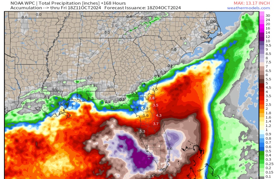
Let’s be clear about what this threat is NOT going to be, before delving into what it might be. First, this is not going to bring rainfall into the southern Appalachians or north Georgia. Thankfully, these decimated areas remain much drier than normal for at least the next week. Second, the Gulf environment is not historically ideal for another major hurricane forming, despite some of the more aggressive model solutions showing otherwise. Third, steering winds blowing from west-to-east should keep anything that develops in the Gulf south of the tattered Big Bend and exhausted Panhandle.
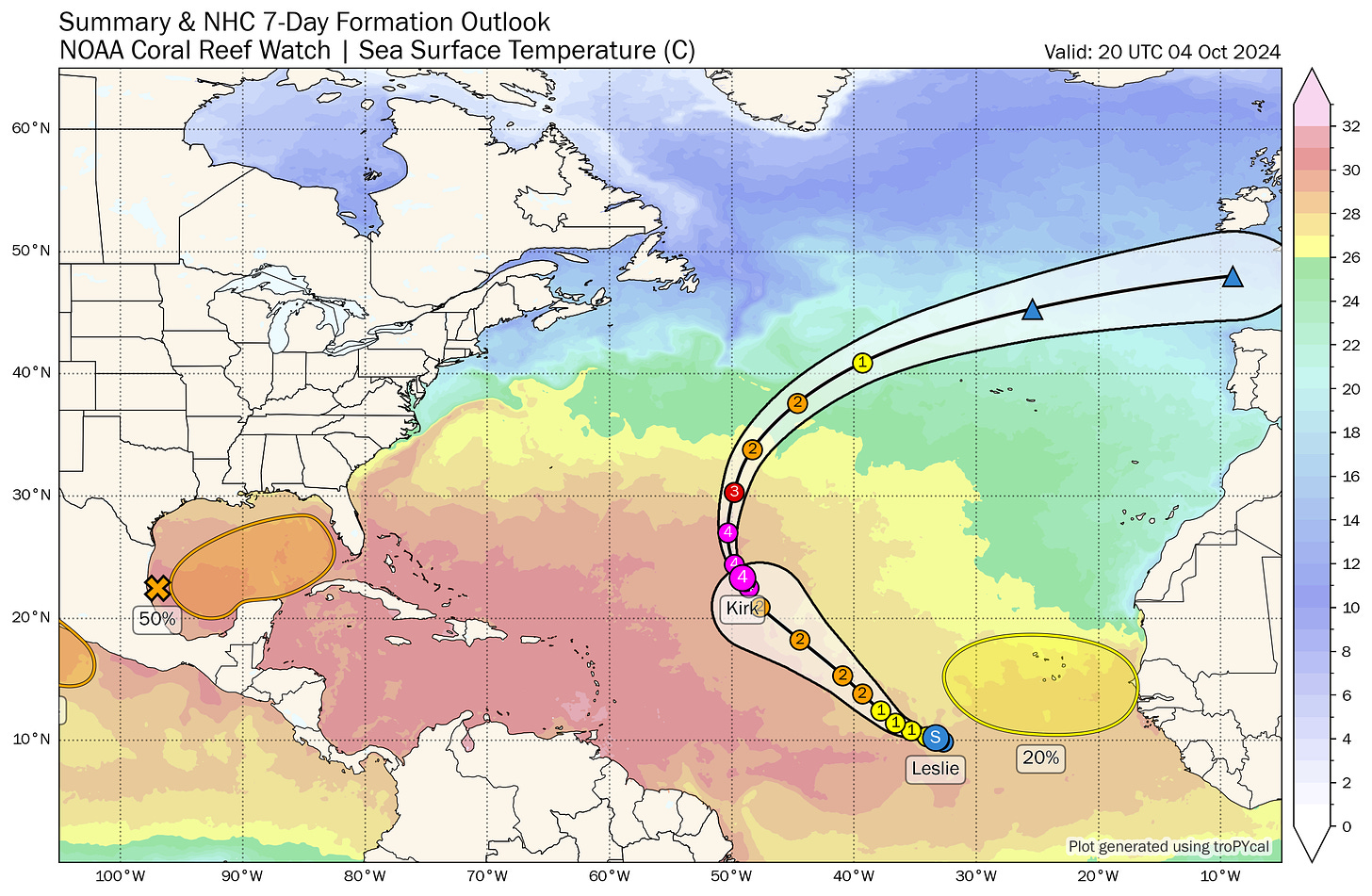
Additionally, there is no landfall threat from a formidable pair of storms in the Central Atlantic, Kirk and Leslie. Hurricane Kirk is 2024’s third Category 4 or higher storm, and the first to not grievously harm people. Kirk (and to a lesser extent, Leslie) will create a heavy surf and rip current hazard at Atlantic beaches over the upcoming week, but otherwise be nice to look at from a distance as they curve out to sea 1,000 miles from land. Here’s to you, Kirk and Leslie, you are today’s real storms of genius.
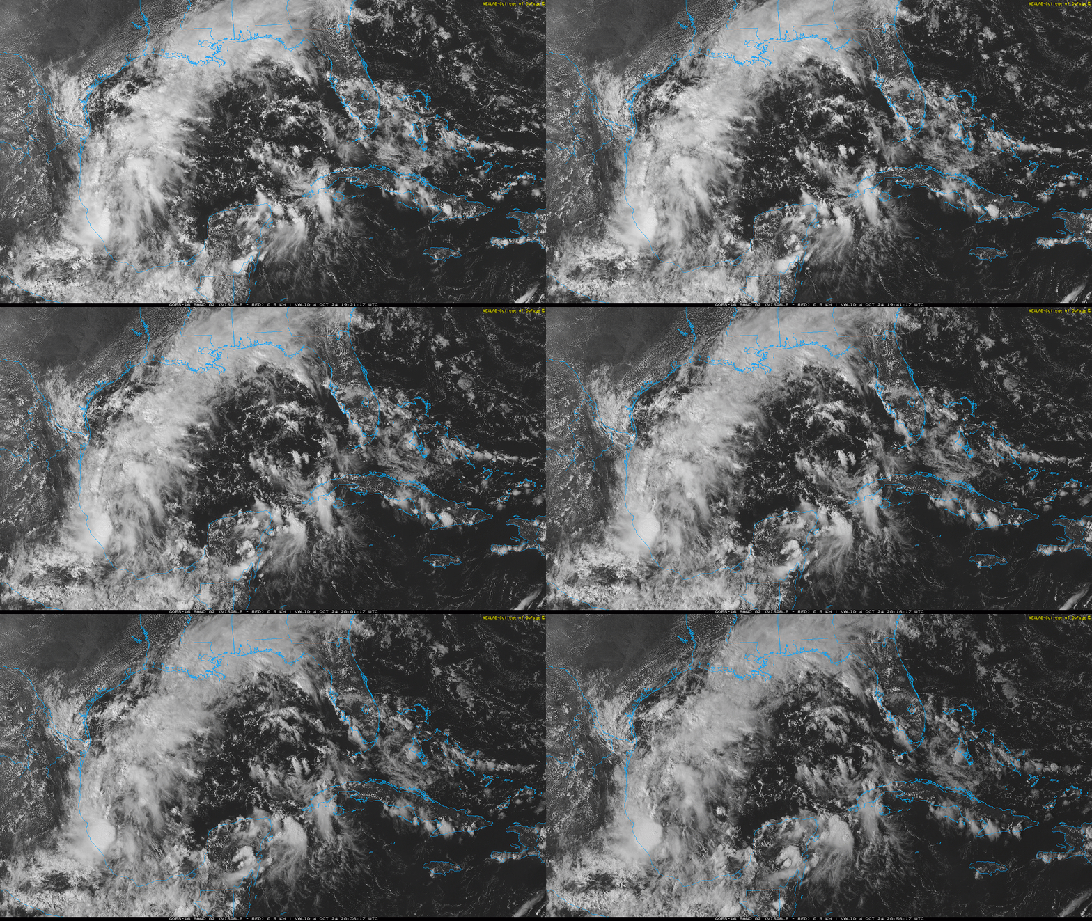
Unfortunately, not all tropical weather is going to follow that gallant example this week. I’ve been watching another Central American Gyre (CAG) take shape over the southern Gulf of Mexico and western Caribbean since last weekend, which has been lingering as a broad disturbance without focused convection. Over the last couple of days, a concentrated dollop of rotation left over from the Eastern Pacific’s Tropical Depression 11-E has crossed southern Mexico and entered the southwestern Gulf relatively intact, gathering storms in the Bay of Campeche. Over the weekend, this shot of energy may jolt the diffuse disturbance into doing what seemed less likely a few days ago: spinning up into a more organized, more tropical system by Monday or Tuesday, albeit one embedded in a complex, not purely tropical environment.
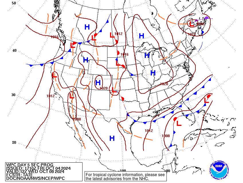
If you’ve been following my forecasts, I’ve been discussing how the several fronts draped across the Gulf in the upcoming week means the structure of low might be broader than that of a usual tropical storm or hurricane, and therefore that it wasn’t clear whether the resulting system would qualify to receive a name from the NHC. The fact that the Pacific disturbance is in the mix and storms are consolidating on the southwestern side of the CAG tilts the odds towards a tropical storm developing, though its interaction with those nearby fronts and jets means widespread rain impacts for Florida no matter whether the disturbance is or is not a named storm.
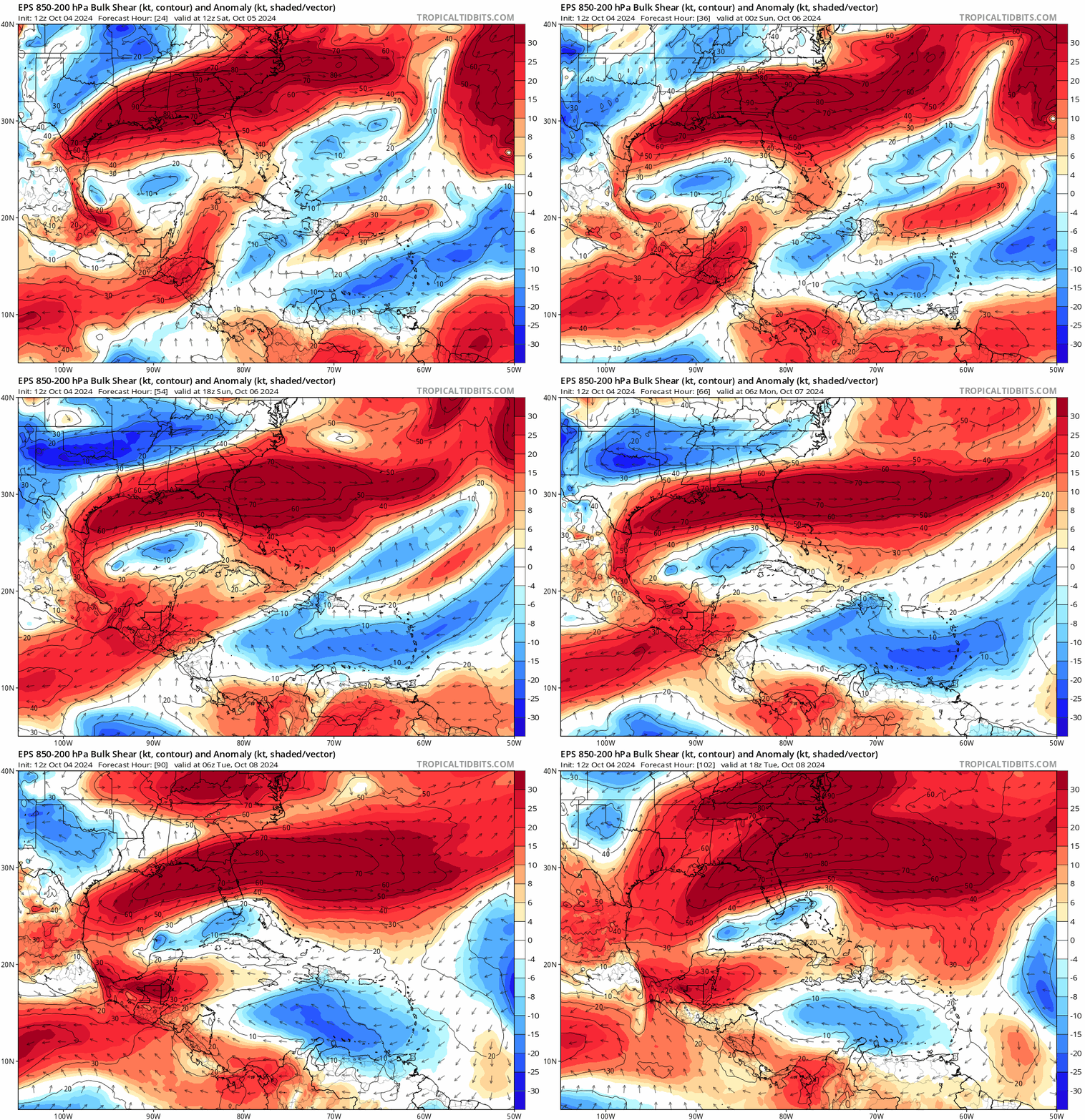
The Gulf is generally a hostile place for tropical activity this week, particularly its northern half where the subtropical jet stream will be blowing west-to-east as a deep trough of low pressure digs into the East Coast. In fact, after some rain chances through Monday, the Panhandle will be chilling on the other side of a protective cool front by Wednesday. As upper-level steering winds direct the low to the east-northeast across the southern Gulf, vertical wind shear is expected increase as it gains some latitude and approaches west-central or southwestern Florida midweek. Given the front to its north, the most probable path of the low is an east-northeastward track crossing the Florida coast somewhere between just north of the Tampa Bay region and the Keys, though that is a highly uncertain forecast at this stage.
If the disturbance comes together quickly through Monday while it is still in a favorable environment over the southern Gulf, hurricane intensity at a midweek landfall is on the table. However, it is also perfectly plausible given the expected uptick in shear starting Tuesday that a less intense, broader, and weaker tropical storm, hybrid low, or convective frontal system may be the end result here. There are still a lot of possibilities, so check back in a few days for a better, or at least less uncertain answer.

The excessive rainfall that will be the most widespread impact of this low is a high confidence forecast across the various scenarios, however. Heavy rain will push east from the Gulf and into South and Central Florida peninsula starting Sunday, particularly along and south of I-4. In Big Bend and north-central Florida, rainfall should be limited and end by Tuesday, with higher potential accumulations the farther south you go. With intermittent heavy rains continuing through at least Wednesday in South and Central Florida, 7-day accumulations there may generally exceed 5” and locally top 10”, and residents should be on alert for flash flood risks.
We’ll wait and see how things play out before discussing potential wind or surge issues, other than to note that the coastal flooding threat is higher in the areas more likely to be south of the track and have onshore flow. Still, this potential should be monitored from the entire Tampa Bay area and south, particularly as the region is still reeling from the aftermath of one of the most severe and widespread surge events on record along the peninsular Gulf Coast.
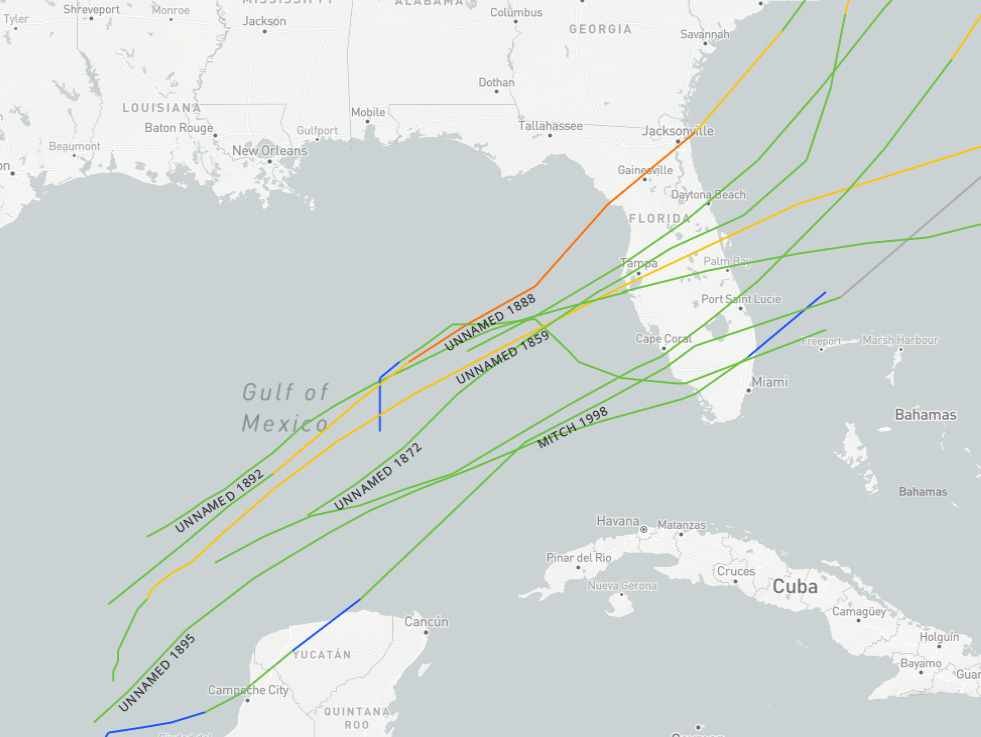
One final note: there’s little precedent for hurricanes striking the Florida Gulf Coast in October on an east-northeast approach, which indicates the shearing influence of mid-latitude weather. Most late-season Florida threats that developed in the southern Gulf hit as tropical storms or were non-tropical lows. However, there are more things in heaven and earth than are dreamt of in climatology, and as we’ve learned once again in the past couple of weeks, the events of our weather past unfortunately do not constrain the threats of the future.
History also shows that Florida’s late-season hurricane risks remain high into late October, shifting south with time. Thus, South and Central Florida will need to pay close attention in the upcoming week, as hurricane season refuses to give us what we all want, and just let us eat our waffles in peace. I’ll be back Monday with an update for all and over the weekend if necessary for paid supporters. Until then, keep watching the skies.


Thank you! I just upgraded my subscription to tell you that I really appreciate your thorough discussion in terms a “layperson “ can understand. I have at least five weather apps that never satisfy me up here on the western Florida Panhandle!
I'm a CoCoRaHS observer in Palm Bay (FL-BV-151), good thing I just got a bigger, shiny new gauge...I guess.
Thanks, as always, for looking out for us!