Major Hurricane Milton Florida Impacts Forecast for October 8th (PM)
Milton's surge, wind, rain, and tornado impacts in Florida, region-by-region.
This post is outdated! Read our landfall liveblog here:
This post may be freely shared. All subscribers will have access to a liveblog providing real-time analysis of Hurricane Milton’s landfall, at time to be announced tomorrow.
A morning briefing covering key overnight developments and forecast changes for paid supporters will continue through Milton. Please consider a paid subscription to support my work and get all of my (literally) round-the-clock coverage of Milton’s impacts on Florida. Back at 9 p.m. with a live forecast video via Facebook that I will also add to this blog post.
Updated 9:45 p.m. with new forecast video at the bottom of the page.
Milton remains on a collision course with west-central Florida, with landfall as a major hurricane expected overnight Wednesday into Thursday morning. Milton will bring catastrophic surge damage to a broad swath of west-central and Southwest Florida, potentially including Tampa Bay, as well as damaging coastal and inland winds and flooding rains to central and north-Central Florida.
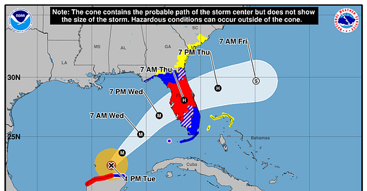
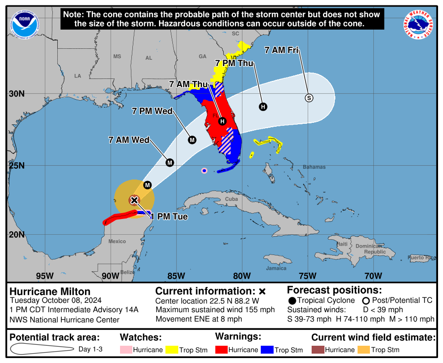
As of the NHC’s 2 p.m. advisory, the center of Hurricane Milton is passing about 65 miles north of the northern Yucatan peninsula and about 500 miles southwest of Tampa. Smoothing out wobbles, Milton is now moving east-northeast at about 8 mph. As tracked by Hurricane Hunter aircraft and Cancun radar, Milton is just a bit south of the NHC forecast track and model guidance through the early afternoon hours. Every mile of latitude matters to the final outcome, but overall there have been no significant changes to the official track forecast over the last several days, which continues to call for a most likely landfall just south of the mouth of Tampa Bay.
The most notable shift in the modeling over the last day has been a trend slower with the timing of the worst impacts in west-central and Southwest Florida, with landfall now expected overnight into Thursday and a possible range between Wednesday night and Thursday mid-morning. Timing uncertainty is greater than cross-track uncertainty with Milton, so while slight adjustments north or south are possible, major changes to the remarkably consistent NHC path prior to landfall are not likely.

Maximum sustained winds are around 155 mph, and Milton remains a powerful Category 4 hurricane. The storm peaked Monday evening as one of the top 5 strongest Atlantic hurricanes on record with sustained winds of 180 mph and a minimum pressure below 900 millibars. Since then, an eyewall replacement cycle diminished the maximum winds and also expanded Milton’s once-tiny windfield outward, though Milton is strengthening slightly again this afternoon. Expect the hurricane to fluctuate around its current intensity through mid-day Wednesday, likely as tropical-storm- and hurricane-force wind radii continue to broaden.
During the day on Wednesday, Milton will accelerate northeastward across the southeastern Gulf of Mexico as it slots into a tight channel of steering winds between a ridge over the western Caribbean and a west-to-east streak of strong winds in the mid-latitude jet stream over the Eastern Seaboard. As Milton approaches the jet streak, it will encounter increasing wind shear Wednesday afternoon and evening. This interaction with strong upper-level winds may result in maximum sustained winds falling a category or two prior to landfall, though I want to emphasize that decline will come at the cost of further expanding Milton’s windfield as it nears Florida. Shear and dry air will continue to impinge on Milton as it cross Central Florida early Thursday, and as it speeds eastward away from Florida by late Thursday.

Milton’s landfall on the Florida peninsula’s Gulf coast on an east-northeast trajectory is a worst-case scenario for the region. Even if the core smears out and maximum winds edge downward before Milton comes ashore, as in the NHC forecast, the cataclysmic coastal flooding impacts of the storm in portions of west-central and Southwest Florida are sealed by the hurricane’s high intensity over the Gulf on Tuesday and Wednesday. Milton is forecast to strike as a major hurricane, and would be the first Category 3+ since 1921 and only the sixth hurricane overall since the 1840s to make landfall between Pasco and Sarasota Counties
This rare trajectory means that a lot of communities directly in the path of Milton only have Helene as any kind of modern reference point, and the worst of Milton’s surge, wind, and rain will exceed Helene’s in west-central and Southwest Florida. Let’s go one-by-one through each of those hazards.
Storm Surge
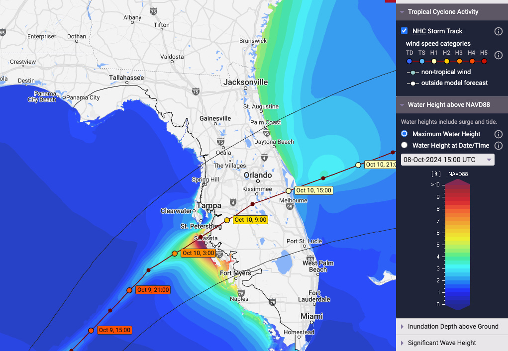
Milton will be a surge event unlike any hurricane in living memory for west-central Florida, with only major hurricane strikes in 1848 and 1921 comparable in scope and height of the coastal flooding. The powerful windfield in Milton’s eastern half will push a wall of water north onto the Gulf’s shallow continental shelf, and any last-minute reduction in maximum winds will not reduce the volume of that onslaught. Simply put, Milton is likely to be for the Tampa Bay to Englewood region what Hurricane Ian was to Charlotte Harbor and south.
As such, Storm Surge Warnings are in place for all of Florida’s Gulf Coast from Cedar Key south to the Everglades. In the Nature Coast, that threat is conditional; 5-10’ of surge is a possibility, but only if the track deviates north towards you, not if it passes south and your dominant wind direction through Milton is offshore. In the Tampa Bay area, NHC modeling calls for a reasonable worst case 10-15’ of surge, which will happen if Milton passes directly over Tampa Bay or tracks just north, as in 1921. This is life-threatening surge without precedent in the Tampa Bay area: as I stated in no uncertain terms yesterday, if you are told to evacuate, leave.
A last-minute escape from the worst of the surge threat is possible for Pinellas and Hillsborough Counties, but only if the center of Milton heads to Bradenton, Sarasota, or Venice. The reality is we likely won't know for sure whether Tampa Bay gets the worst surge impacts from Milton until mere hours before the storm makes landfall, when it is too late to leave. Plan and act for the worst here because the margins really are that thin and the bad outcomes really are that dire. The fact that high tide in Tampa Bay is around sunrise on Thursday further exacerbates the existential threat.

Catastrophic surge is more certain the further south you go across the west-central Florida coastline, as landfall is unlikely to be south of Englewood, and anyone along or south of the center will receive catastrophic coastal flooding from a combination of ill-timed high tide, extreme wave action, and onshore winds. Inundation above mean sea level of 10’ or more will exceed any recent storm at least south to Englewood, with a severe 6-10’ of surge expected in and around Charlotte Harbor and the barrier islands struck so fiercely by Ian. Significant, dangerous coastal flooding is baked in as well all the way south through Naples and Marco Island into the Everglades.
Finally, pivoting to a less-discussed aspect of Milton: coastal flood impacts on the northeast Florida and south Georgia coasts. Areas north of Cape Canaveral north to roughly Savannah will see strong onshore flow out of the northeast through the day on Thursday, worsened by Milton’s interaction with the jet streak. This area, including Jacksonville, St. Augustine, Daytona Beach and the St. Johns River, can expect 3-6’ of surge, likely worst during high tide late Thursday morning or early Thursday afternoon. Cape Canaveral to the Georgia border is also under a Storm Surge Warning, with a Storm Surge Watch extending north to Charleston.
Wind
Of the three main threats, Florida’s wind impacts forecast is the least certain at this time. The reason for that is that wind predictions not only have to take into account uncertainty in track and timing, but also how the storm’s windfield will be structured, and where it will be most conducive for stronger winds above the surface to mix down to ground level. The NHC forecast calls for Milton to make landfall as a Category 3 hurricane with an embattled inner core but an expanding outer windfield of tropical-storm-force winds, and is it unclear to what extent this core breakdown will or will not have occurred when the storm reaches land. All else equal, the trend towards pushing landfall back a few hours helps the west-central Florida coast a bit by giving the wind shear more time to do work against the hurricane’s powerful eyewall.
With that said, the Hurricane Threats and Impact wind risk product from the National Weather Service highlights the region from Brooksville to Lakeland to Englewood, including all of the Tampa Bay region, as having the highest odds of receiving structurally damaging wind gusts above 110 mph overnight Wednesday into Thursday. Not everywhere in this zone will see that, but this is the region where the threat to be directly struck by Milton’s eyewall containing those destructive gusts is greatest. As is the case during hurricane-jet stream interactions, the winds on the northern half of the storm may actually be strongest (despite the east-northeastward movement of the storm), as dry air works into the south side of the hurricane.
As the core weakens over land Thursday morning, near-hurricane and hurricane-force wind gusts are likely to overspread Central Florida at the height of the storm. East Central Florida, including the Orlando area, is not likely to see a concentrated blast of intense hurricane-force winds as in Charley. Rather, look for tropical-storm-force wind gusts beginning late Wednesday and peaking Thursday morning with the kind of 60 to 80 mph gusts generally experienced in the Orlando area in Jeanne, Irma, or Ian, gradually subsiding Thursday afternoon. Expect vicious hurricane-force wind gusts out of the northeast along the Atlantic coast on Thursday, roughly between Brevard and St. Johns Counties. Those regions are all under Hurricane Warnings.
South Florida and North Central Florida are under Tropical Storm Warnings, and wind impacts of Milton are likely to be more measured there. Areas south of Lake Okeechobee and away from the Gulf Coast will likely see occasional low-end tropical-storm-force winds gusts, mostly in bands on Wednesday. Lake City, Ocala, Gainesville, and the rest of north-central Florida and the eastern Big Bend will see peak gusts probably in the 40 to 60 mph range early Thursday. Again, local wind impacts a couple days out from a hurricane are a low confidence forecast, especially in this case, so regard this gust guidance as an initial guideline rather than a certainty and keep an eye on changes to the NWS Hurricane Threats and Impacts products.
Rainfall
When people think of hurricane threats, excessive rainfall causing flash, urban, and river flooding didn’t used to necessarily come to mind. Helene’s biblical deluge underscores the fact that more than a third of tropical cyclone-related casualties are caused by freshwater flooding, which was also a deadly inland hazard in Ian.
While surge remains the top water threat from Milton, particularly as the coast under the gun is densely developed, heavy rainfall is going to be a widespread impact. With much of the Florida peninsula either soaked by Helene or seeing several inches of rain this week not directly associated with Milton, some west-central and north-central Florida rivers are already at flood stage, and saturated ground is primed for flooding. Current guidance calls for general 5-10” storm rainfall totals in a box enclosing Jacksonville, Cedar Key, Venice, and Melbourne, with an embedded region of 10-15” accumulations most likely along or just north of the I-4 corridor. Rain totals drop rapidly to the northwest, with most of the Panhandle seeing little or nothing, though heavy rainfall is possible in the eastern Big Bend depending on Milton’s exact track. Dry air will wrap around the south side of the hurricane towards landfall, so look for 1-3” rain totals across South Florida, mostly in bands early Wednesday.
In west-central and north-central Florida, heavy and persistent rainfall beginning Wednesday afternoon and extending through mid-day Thursday will be fueled by the hurricane’s interaction with the jet streak to its north. The flood threat continues to rise in these areas, and the National Weather Service is highlighting the Tampa, Orlando, and Nature Coast areas as being at highest risk of excessive rainfall causing flash flooding. “High risk” rain forecasts (like those issued preceding Helene) are quite rare and account for much of recorded flood damage. We should know by now to take the flood threat as seriously as the surge or wind, including by not driving into floodwaters of any depth. There is also a slight risk of quick-developing tornadoes within bands over south-central and South Florida, mostly Wednesday afternoon, but this is less of a concern than the other hazards.
In short, it’s hard to find much of a forecast cause for optimism. Milton will combine a generational surge threat to west-central Florida with widespread wind impacts and a long tail of elevated river and flash flood potential. Everyone in the Florida peninsula should be closely monitoring the latest information from the National Hurricane Center, your local National Weather Service office, and your country’s emergency management office. If you still need to evacuate the Gulf Coast surge zone, you should, but do it before the weather turns bad tomorrow morning. Take the Coastal Highway for less traffic and to validate your decision by seeing what the aftermath of a Category 4 looks like in the Big Bend.
Good luck, Florida. Yet again, we need it, though our supply seems to be wearing thin. I will be continuing to cover Milton blow-by-blow until all threats ease. Until then, keep watching the skies.
Evening forecast video below:


![WeatherTiger's Hurricane Milton Landfall Live Blog [New Post: 5:35 p.m.]](https://substackcdn.com/image/fetch/w_1300,h_650,c_fill,f_auto,q_auto:good,fl_progressive:steep,g_auto/https%3A%2F%2Fsubstack-post-media.s3.amazonaws.com%2Fpublic%2Fimages%2F0b62ec3b-f387-46ea-8d8f-3d24639c625e_911x573.png)


![[Image of cumulative wind history] [Image of cumulative wind history]](https://substackcdn.com/image/fetch/w_1456,c_limit,f_auto,q_auto:good,fl_progressive:steep/https%3A%2F%2Fsubstack-post-media.s3.amazonaws.com%2Fpublic%2Fimages%2F6a443e5e-b1a8-443e-ab50-28c9163c30fb_897x736.png)


![[Image of Rainfall Potential] [Image of Rainfall Potential]](https://substackcdn.com/image/fetch/w_1456,c_limit,f_auto,q_auto:good,fl_lossy/https%3A%2F%2Fsubstack-post-media.s3.amazonaws.com%2Fpublic%2Fimages%2F131095f7-f239-4fe6-98f0-57744e442a07_892x716.gif)
![[Image of WPC Flash Flooding/Excessive Rainfall Outlook] [Image of WPC Flash Flooding/Excessive Rainfall Outlook]](https://substackcdn.com/image/fetch/w_1456,c_limit,f_auto,q_auto:good,fl_lossy/https%3A%2F%2Fsubstack-post-media.s3.amazonaws.com%2Fpublic%2Fimages%2F0e2f0609-d09a-4030-a39c-2536126d491d_1090x692.gif)
P.S., Ryan (aka Dr. Hurricane), you are doing a great thing for your fellow Americans by providing guidance and information that perhaps, may save many lives. For that, I am most grateful. Keep those LaCroix flavors close at hand @ WT World HQ's and keep hydrated through this awful mess.
Great job Ryan. I for one, and my family and friends really appreciate your hard work. Mark Hoffman