


Wake-Up Call: The Hurricane Watch for June 16th
Development is now more likely than not in the eastern Atlantic in the next 5 days.
Florida tropical threat synopsis: No tropical threats to Florida over the next 8-10 days. Enhanced rainfall coverage will continue over the state for the next week.
Almanac: It’s Friday, June 16th… day 16 of the 2023 hurricane season, 167 days to go. By total storm energy, the season is 1.5%, 3.7%, and 4.4% complete for the Atlantic, continental U.S., and Florida, respectively. On this date in 2015 (the most recent June with an active El Nino), TS Bill made landfall in Texas and caused significant flooding.

Active Storms: None.
Other Disturbances in NHC outlook, with 2-/7-day NHC development odds: NHC odds of development have increased to 20% in the next 2 days and 60% in the next 7 days as the wave in the eastern Atlantic between 20-25W has further consolidated in the last day. Deep convection is now along and east of the wave axis, and looking at the satellite loop below, you’d be hard-pressed to guess it was June rather than August or September.

And in many ways, it may as well be, with SSTs near peak season values, shear declining in the path of the wave to 10-15 knots, and mid-level moisture increasing over the weekend. With the ingredients of tropical development in place and a potent disturbance, there is a strong chance of a tropical storm developing in the next 3-6 days as the wave continues westward toward the Lesser Antilles. In fact, every single member of the Euro ensembles is showing at least some development.

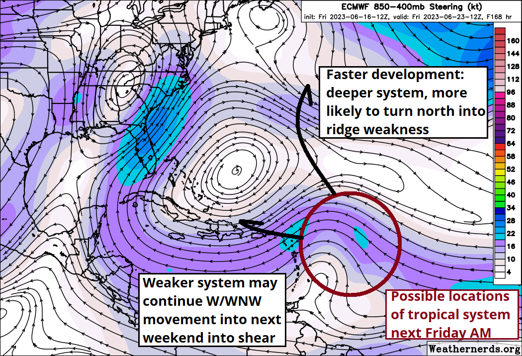
In fact, models are getting quite enthusiastic, with some even hinting at hurricane intensity in about a week— which would be truly unprecedented for the eastern Atlantic in June. This system should continue WNW until encountering a gap in subtropical ridging late next week, at which a stronger system would likely turn north into the open Atlantic, while a weaker system might keep moving west in the general direction of the Greater Antilles into days 8-10. However, the southwestern Atlantic does not look very conducive for significant tropical activity late next week, with shear picking up as eastern troughing re-develops.
Anyway, while development is likely early next week, anything that forms still doesn’t look like a concern for the continental U.S. coast. However, interests in the Antilles, including Puerto Rico, should be carefully following the situation.
Elsewhere: Nothing else in the Atlantic, Gulf, or Caribbean of note. The GFS has at long last thrown in the towel on spurious development of a storm in the Caribbean, though some disorganized moisture may move north towards Florida in 5 days or so and further enhance rain coverage in an already unsettled pattern for the state.
Next report: Subscriber bulletin Monday afternoon.


