Tropical Storm Debby Morning Briefing for August 4th
Debby is on track to strike the Big Bend as a Category 1 hurricane tomorrow. Here's what's changed overnight.
This forecast is outdated! View WeatherTiger’s Sunday evening Debby forecast here.
WeatherTiger’s Hurricane Watch is a reader-supported publication. Paid subscribers get Florida-focused daily tropical bulletins, plus weekly columns, full coverage of every hurricane threat, our real-time seasonal forecast, and the ability to comment on posts. Paid supporters will receive an exclusive morning forecast tomorrow with overnight developments on Debby.
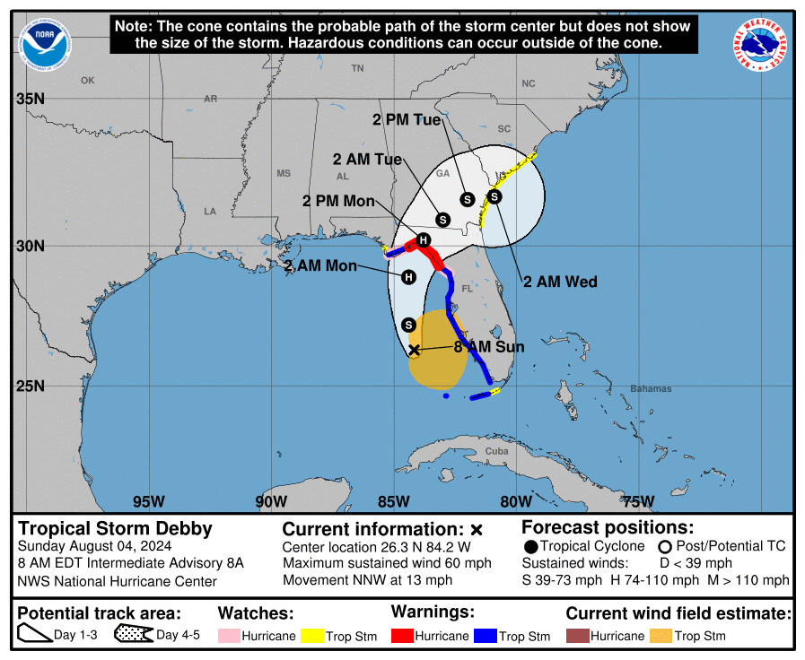
Debby has intensified to a tropical storm with sustained winds of 60 mph this morning while moving across the eastern Gulf of Mexico, with minimal changes in its expected path overnight. The official NHC track is still for a path into Apalachee Bay, meaning that Debby will bring dangerous surge and wind over at least eastern Apalachee Bay and possibly farther west, and may track close enough to cause wind impacts in Tallahassee.
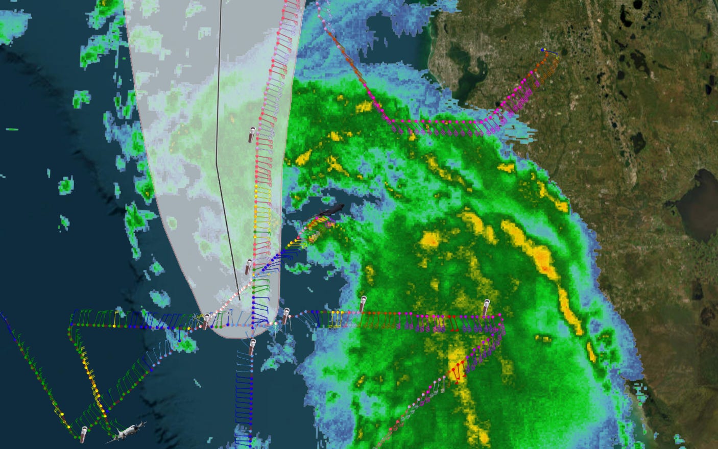
As of the NHC’s 8 a.m. intermediate advisory, Tropical Storm Debby is located about 150 miles southwest of Tampa, moving north-northwest at about 13 mph. Debby’s movement this morning is following the 5 a.m. NHC forecast track, and has bent more to the north overnight, as expected. However, ongoing Hurricane Hunter flights show that Debby’s vortex is quite tilted to the east going up in the atmosphere; recon data shows the surface center is right on the NHC track, but overlaying radar, the heavier storms (and highest winds) are 30 miles or more to the east and closer to the mid-level center of circulation. It appears that the low-level center may be reforming east to be under that mid-level center as of late Sunday morning, which might shift the track east but also set up more intensification.
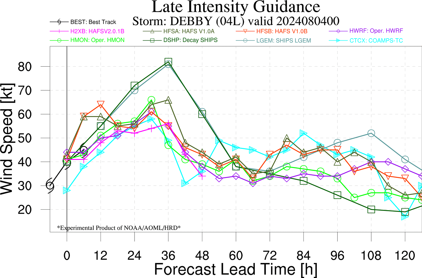
Maximum sustained winds have increased to 60 mph. Overnight, the NHC intensity nudged the expected peak intensity at landfall up to 85 mph, which is just slightly higher than Hurricane Hermine’s landfall intensity. Overall, hurricane intensity model guidance shows steady but not rapid intensification for the next 24 hours until Debby reaches North Florida. The misalignment of the low- and mid-level centers is an initial impediment to strengthening, but that appears to be changing in a way that might unlock the potential for faster intensification later today.
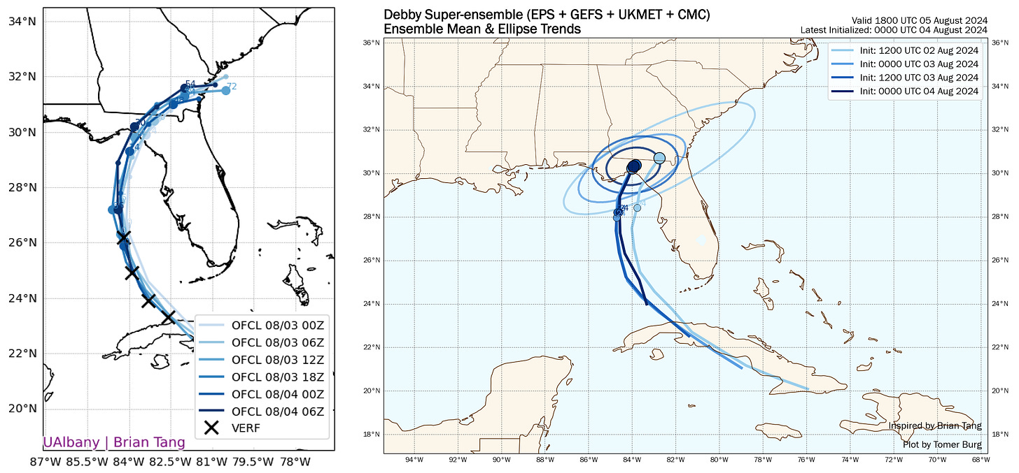
Another change to be aware of this morning is that the NHC track forecast has nudged ever so slightly west, and the 5 a.m. advisory track brings Debby to the the coastline somewhere in Taylor County by mid-day tomorrow. Overnight model guidance on the whole has not changed much and is zeroing in on the eastern Panhandle, though there is a split between the GFS and U.S. hurricane models taking Debby into western Apalachee Bay, then basically over of Tallahassee, and the European model taking Debby into eastern Apalachee Bay and just east of Tallahassee. This split is very similar to how the model tracks divided 24-36 hours before Idalia’s landfall, and the NHC’s track forecast may be a little east of the model consensus in recognition of the Euro’s more eastward scenario winning out that time.
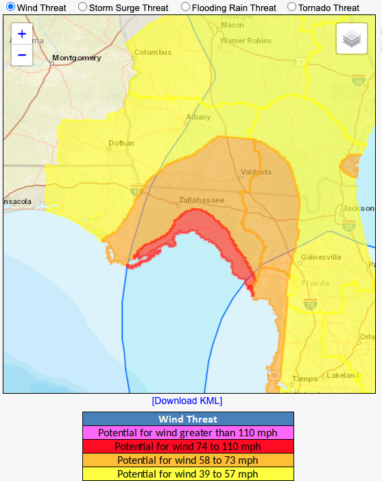
I’ll get deeper into impacts this afternoon, but my overall expectations haven’t changed all that much from what I laid out yesterday evening. Wind impacts are sensitive to the exact track, as the core of damaging winds will probably only be 40 or so miles wide and narrow quickly once the hurricane moves inland. If the western guidance cluster is accurate, Tallahassee would receive the what is left of the core of Debby post-landfall, and impacts might be similar to what we saw in 2016 with Hermine (though Debby may be moving a little slower, which would help inland areas). If the eastern Apalachee Bay track plays out, wind impacts in Tallahassee would be similar to but likely less than seen in Idalia. The latest wind risk product from the NWS highlights that all of the Apalachee Bay coast is at risk of seeing hurricane-force wind gusts, with high-end tropical-storm force gust risks extending across the eastern Panhandle and Big Bend. Not everywhere in those highlighted areas will see those winds, but those are the areas at risk.
Life-threatening storm surge of 6-10’ is now the peak range in eastern Apalachee Bay, and 4-8’ values are also possible in western Apalachee Bay if the track shifts in that direction. Surge is expected to be 2-4’ over much of the rest of the Florida Gulf Coast, where heavy bands are already overspreading the state north to Tampa as of 9 a.m. The area of highest surge danger is between roughly St. Marks and a little Cedar Key, where again, Hermine’s surge values are probably a decent guide as to what to expect. (Surge topped out at 7.5’ in Cedar Key then.)
Overall, the most likely outcome is that coastal counties of eastern Apalachee Bay (Taylor, Dixie, and Levy Counties) get the brunt of some dangerous storm surge as well as damaging winds from Debby tomorrow. In Tallahassee, we still don’t know if wind gusts will be in the Idalia-like 40-55 mph or the Hermine-like 55-70 mph range-it could still legitimately go either way, though I am leaning towards a more eastward track with a landfall near or just north of Steinhatchee. Finally, the real threat down the road, not just to North Florida but also eastern Georgia and the coastal Carolinas, remains the extreme rainfall totals caused by Debby’s expected slow motion between tomorrow and at least Thursday: rain totals of 5-15” are expected in these areas, causing a high risk of flash flooding. These risks are unchanged this morning.
I’ll be back around 5:30 p.m. with a full analysis of region-by-region impacts expectations and a live forecast video at 9:30 p.m. this evening.


![[Image of cumulative wind history] [Image of cumulative wind history]](https://substackcdn.com/image/fetch/w_1456,c_limit,f_auto,q_auto:good,fl_progressive:steep/https%3A%2F%2Fsubstack-post-media.s3.amazonaws.com%2Fpublic%2Fimages%2F6dae72e1-582f-4b10-924d-c5eaad1f56e8_897x736.png)
![[Image of WPC Flash Flooding/Excessive Rainfall Outlook] [Image of WPC Flash Flooding/Excessive Rainfall Outlook]](https://substackcdn.com/image/fetch/w_1456,c_limit,f_auto,q_auto:good,fl_lossy/https%3A%2F%2Fsubstack-post-media.s3.amazonaws.com%2Fpublic%2Fimages%2Ff81b42c1-91f8-4f14-8ec8-c16619182079_893x746.gif)
Doctor, you never have to answer my comments. Kind of a USF-UF struggle. Yesterday's track over UF now near FSU. I am neutral, my son graduated from FSU, my wife got her Masters at UF.
John
The 11 a.m. NHC forecast now calls for a landfall intensity Monday AM of 90 mph, with Debby's most likely landfall somewhere between Steinhatchee and St. Marks.
With low- and mid-level centers now better aligned, chances of rapid intensification have risen from earlier today.