Tropical Storm Debby Florida Impacts Forecast for August 3rd
Tropical Storm Debby will likely become a hurricane before reaching North Florida on Monday.
WeatherTiger’s Hurricane Watch is a reader-supported publication. Paid subscribers get Florida-focused daily tropical bulletins, plus weekly columns, full coverage of every hurricane threat, our real-time seasonal forecast, and the ability to comment on posts. Paid supporters will receive an exclusive morning forecast tomorrow with overnight developments on Debby.
Tropical Storm Debby has entered the southeastern Gulf of Mexico, hitting start on a countdown to an expected Monday landfall in Florida’s Big Bend or eastern Panhandle. While there is some clarity today on Debby more likely than not reaching North Florida as a hurricane, how long the storm’s heavy rains will linger over Florida, eastern Georgia, and the coastal Carolinas remains up in the air.
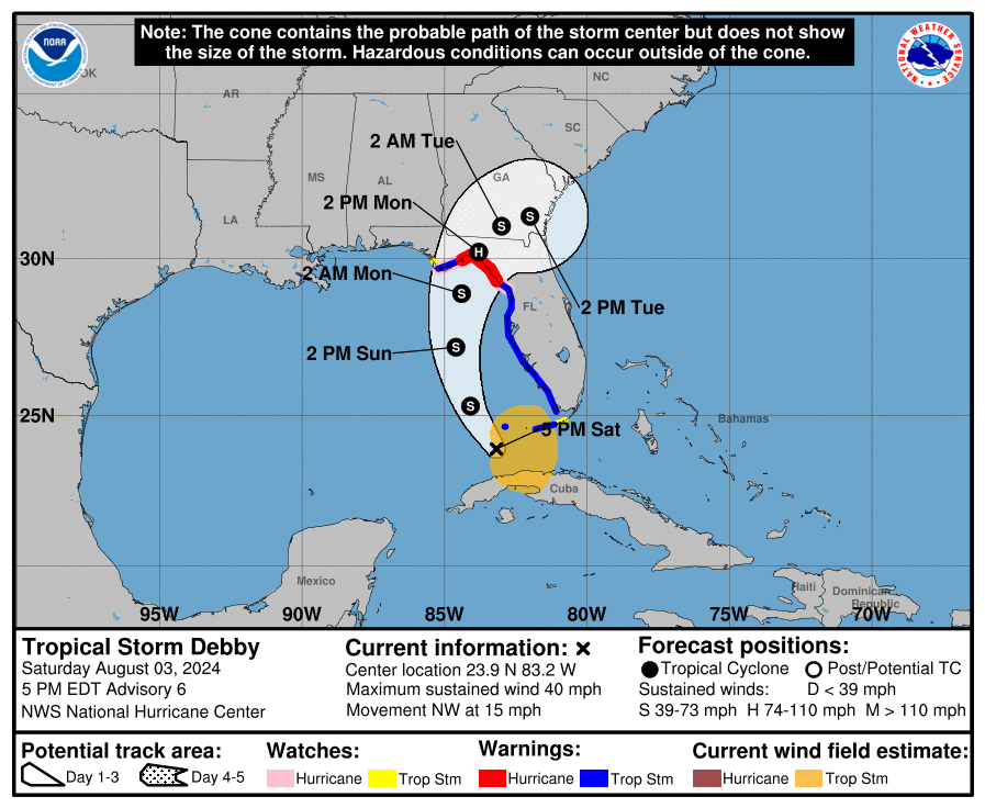
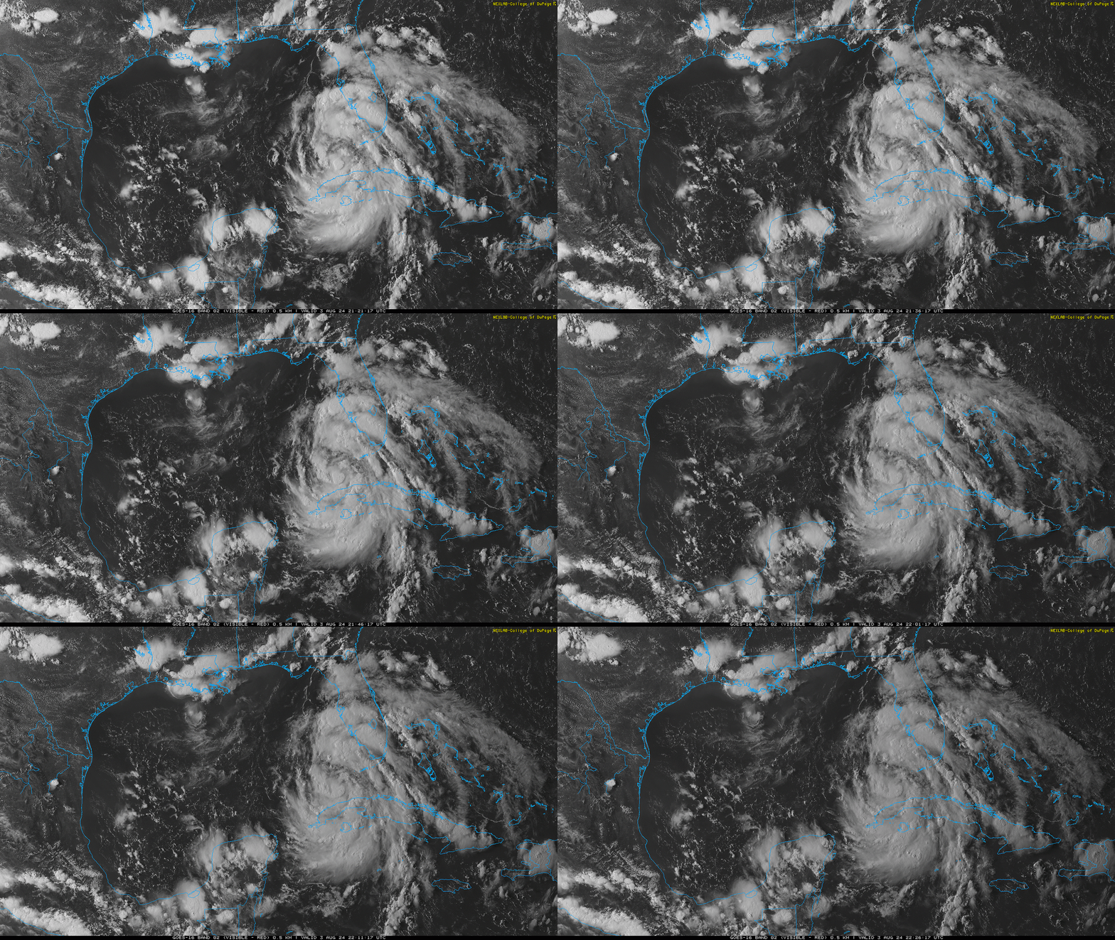
As of the 5 p.m. Saturday NHC advisory, Debby is located about 100 miles southwest of Key West, with sustained winds up to 40 mph. The storm is now moving northwest at about 15 mph, following a path that has bent more northwestward today as Debby connects with an eastern U.S. dip in the jet stream. With Debby’s circulation consolidating farther southwest than yesterday’s NHC forecasts suggested, the most likely path of the center has also shifted west, away from Florida’s Nature Coast and towards the eastern Panhandle over the last 24 hours.
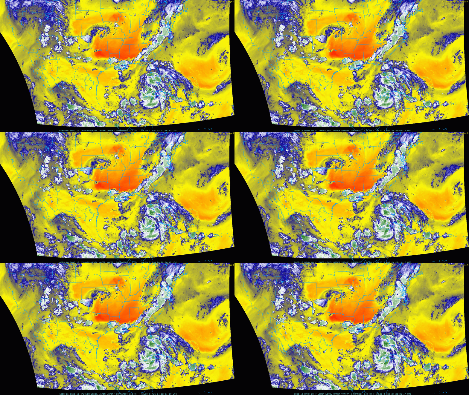
Though Debby formed farther west, water vapor imagery shows the upper-level trough pushing hard into the Deep South today, which will turn the storm north on Sunday, then north-northeast by early Monday. With that key steering feature developing as expected, I do not foresee further big shifts west in Debby’s track from what the NHC is predicting this evening. On this path, Debby will likely cross the coast between Carrabelle and Cedar Key by Monday afternoon. Hurricane Warnings are now in effect for much of Apalachee Bay, with Tropical Storm Warnings for the rest of Florida’s Gulf Coast west to Cape San Blas.
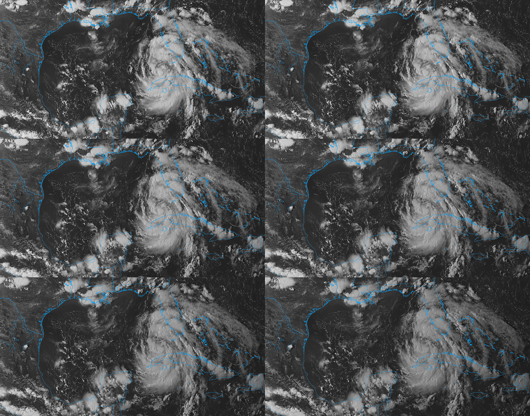
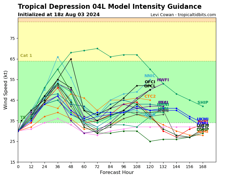
As the forecast track has evolved to give Debby more time over water, the forecast intensity at landfall has edged higher as well. This afternoon, deep convection has gathered closer to Debby’s center of circulation, with more organized outer bands spreading intermittent heavy rainfall over the Florida peninsula. This consolidation signals a strengthening storm, and continued steady intensification is likely through early Monday as Debby moves beneath a very favorable outflow environment in the eastern Gulf.
However, Debby’s circulation is large and sprawling, and the storm may ingest some drier air at the mid-levels of the atmosphere starting late Sunday. This should keep the rate of strengthening in check, and makes rapid intensification during the approach to North Florida less likely. The NHC is now predicting that Debby will reach Category 1 intensity by landfall, which seems like a reasonable balance of the positive and less supportive environmental and structural factors in play.
So, with first landfall around 36 hours out, let’s take a quick look at how the four main types of weather impacts of a hurricane (wind, surge, tornadoes, and flooding rainfall) are likely to play out in Debby. I’ll be refining these ideas further by region in tomorrow’s forecast, but this is the state of play as of Saturday evening.
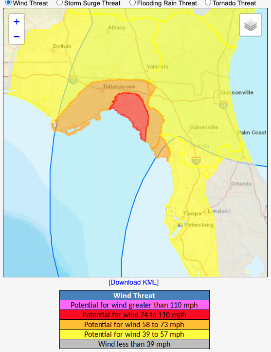
Wind
With Debby flexing to Category 1 intensity prior to landfall, wind impacts in northern Florida will be locally significant in the areas that receive the hurricane’s eyewall, and less severe but still damaging outside of that area. It’s too early to say exactly where the eyewall will come ashore, but right now eastern Apalachee Bay and areas immediately adjacent to it are at the highest risk of receiving at hurricane-force wind gusts. While I’m not talking about Debby’s worst being in the same league as Idalia’s worst, 65 to 85 mph wind gusts in same vulnerable areas of the eastern Big Bend that were walloped by Hurricane Idalia last year will do notable damage, especially to trees and powerlines.
Debby’s speed of forward motion is likely to diminish on Monday as it approaches the coast, which reduces its potential to carry hurricane-force gusts well inland. Nevertheless, the Panama City to Gainesville region should prepare for at least lower-end tropical-storm-force wind gusts, which are also probable along most of the Florida peninsula Gulf Coast through Monday. As in Idalia, the western half of Debby will see notably weaker wind gusts than the eastern half. It’s too soon to know whether Debby will move east or west of Tallahassee, which will make the difference between lower-end (east) or higher-end (west) tropical-storm-force wind gusts in the capitol region. I’d lean east, but stay tuned.
Storm Surge
As of 5 p.m. Saturday, Storm Surge Warnings are in effect for all of Apalachee Bay and most of the Nature Coast, with Storm Surge Watches for the Tampa Bay area south to Fort Myers. There is high confidence of 2-3’ of surge along the peninsular Gulf Coast north to Cedar Key with local values to 4’+ on the Nature Coast.
In Apalachee Bay, the threat is more conditional; as in Idalia, surge will be highest at 4-7’ along and just east of where the eyewall tracks, with little or no surge west of the center with offshore winds. The eastern half of Apalachee Bay is more likely to get those peak surge values, but you need to be preparing for destructive surge in western Apalachee Bay as well, even though it is less likely to actually occur. As always, monitor (and heed!) evacuation guidance from your county’s local emergency management office.
Tornadoes
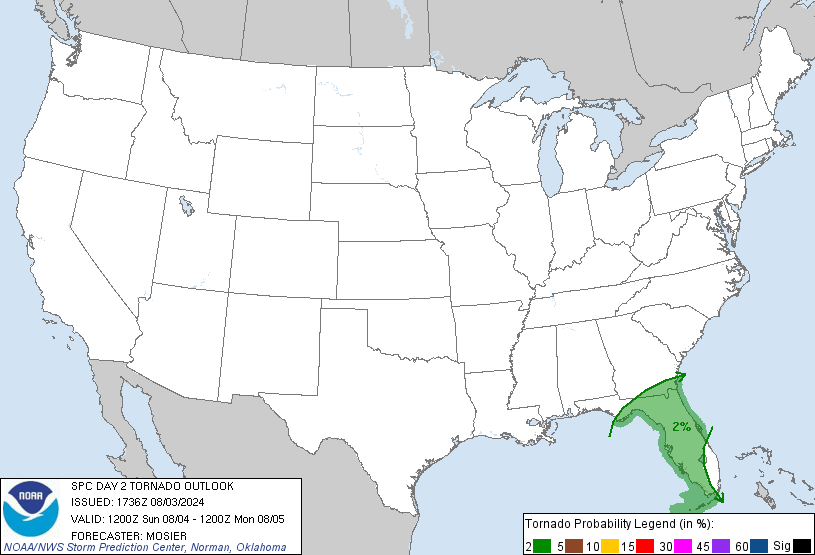
The tornado threat from Debby is not particularly acute. There is potential for some tornadoes over the peninsula and northeast Florida through mid-day Monday, but a major outbreak is unlikely.
Rainfall
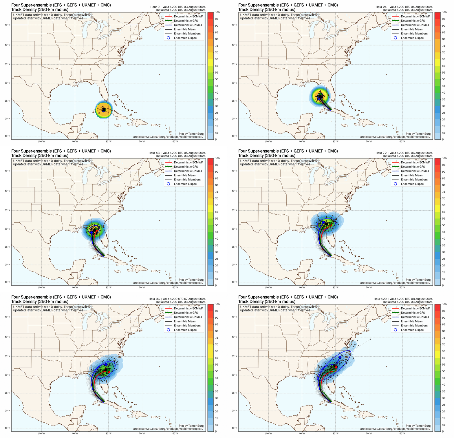
I’ve left heavy rainfall for last, even though it will likely be the most destructive impact of Debby. The reason for that is the long-term forecast for what will happen to the storm after it makes landfall remains a real enigma, other than we know it won’t be going anywhere in a hurry. With steering winds diminishing to next-to-nothing in the vicinity of the Southeast on Tuesday, Debby will likely slow down and turn more eastward into Georgia, the with official NHC track drifting Debby into coastal South Carolina by Thursday. That’s as good a guess as any, but with global models showing the dreaded “squashed spider” formation, in which model track “legs” bulge haphazardly in all directions beyond Tuesday, only a fool would be confident as to where Debby will drift over North Florida, Georgia, the Carolinas, next week.
This means all of those areas should be monitoring the possibility of flash flooding and river flooding into next weekend, by which point whatever is left of Debby should belatedly ease away to the northeast. In the shorter-term, tonight and Sunday will bring intermittent heavy rain bands to the Florida peninsula, most frequent in western sections. The eastern Panhandle and Big Bend will see periodic rainfall early Sunday, with steadier and heavier rain moving in late on Sunday and continuing through at least Monday. Northeast Florida into the coastal Carolinas will see steadier rain develop between late Sunday and Monday afternoon, persisting into midweek or beyond. Overall, look for 2-5” of rain in the Florida peninsula over the next 3 to 5 days, with a probable 6” and possible local totals to 15” in North Florida (minus the much drier western Panhandle), and eastern Georgia, South Carolina, and North Carolina through the next 7 days.
Overall, Tropical Storm Debby is a storm to take seriously. Debby isn’t going to pack the punch of a major hurricane like Michael or Idalia, but it might wind up crossing the notable coastal wind and surge impacts of Hermine with the flooding potential of 2008’s Tropical Storm Fay in North Florida. I’ll be back tomorrow with a region-by-region look at Florida’s expected impacts from Debby. In the meantime, use the next day to do what you need to do to be ready, and keep watching the skies.
Next update: Short update exclusively for paid subscribers tomorrow morning by 9 a.m.; complete forecast for all tomorrow afternoon.


![[Image of cumulative wind history] [Image of cumulative wind history]](https://substackcdn.com/image/fetch/w_1456,c_limit,f_auto,q_auto:good,fl_progressive:steep/https%3A%2F%2Fsubstack-post-media.s3.amazonaws.com%2Fpublic%2Fimages%2Fff35db6a-9570-4e61-820e-6a245a7728cf_897x736.png)
![[Image of U.S. rainfall potential] [Image of U.S. rainfall potential]](https://substackcdn.com/image/fetch/w_1456,c_limit,f_auto,q_auto:good,fl_lossy/https%3A%2F%2Fsubstack-post-media.s3.amazonaws.com%2Fpublic%2Fimages%2Fdb2fd15d-0a88-4c00-880f-763b0b0d0425_892x716.gif)
![[Image of WPC Flash Flooding/Excessive Rainfall Outlook] [Image of WPC Flash Flooding/Excessive Rainfall Outlook]](https://substackcdn.com/image/fetch/w_1456,c_limit,f_auto,q_auto:good,fl_lossy/https%3A%2F%2Fsubstack-post-media.s3.amazonaws.com%2Fpublic%2Fimages%2Feb1b504f-fd29-4cf8-9ac2-497c31f1ba83_893x746.gif)
Stay safe Doc!
Good morning. I am a paid subscriber looking for the 9:00 update. Thought perhaps I was not looking in the right place. I was hoping you could provide your best estimate of potential winds in Woodville and Capitola. Thank you.