


The Slope of Hope: Hurricane Watch Weekly Column for October 19th
Tropical Storm Tammy is a threat to the northern Lesser Antilles but not the continental U.S.; keep an eye on the tail end of October closer to home as the season wanes.
WeatherTiger’s Hurricane Watch is a reader-supported publication. Paid subscribers get Florida-focused daily tropical briefings, plus weekly columns, full coverage of every hurricane threat, our exclusive real-time seasonal forecast model, and the ability to comment and ask questions for $49.99 per year.
As the days of hurricane season dwindle to a precious few, both your patience for lingering tropical activity and my stamina to guide you through it are in short supply, as demonstrated by the crumpled burrito receipt on my desk with “Hocus Pocus theme??” scribbled on it. While I decline to follow the siren song of that receipt, I can reassure you that there are no indications of any tropical threats running amuck, amuck, amuck near Florida or the continental U.S. for at least the next week.
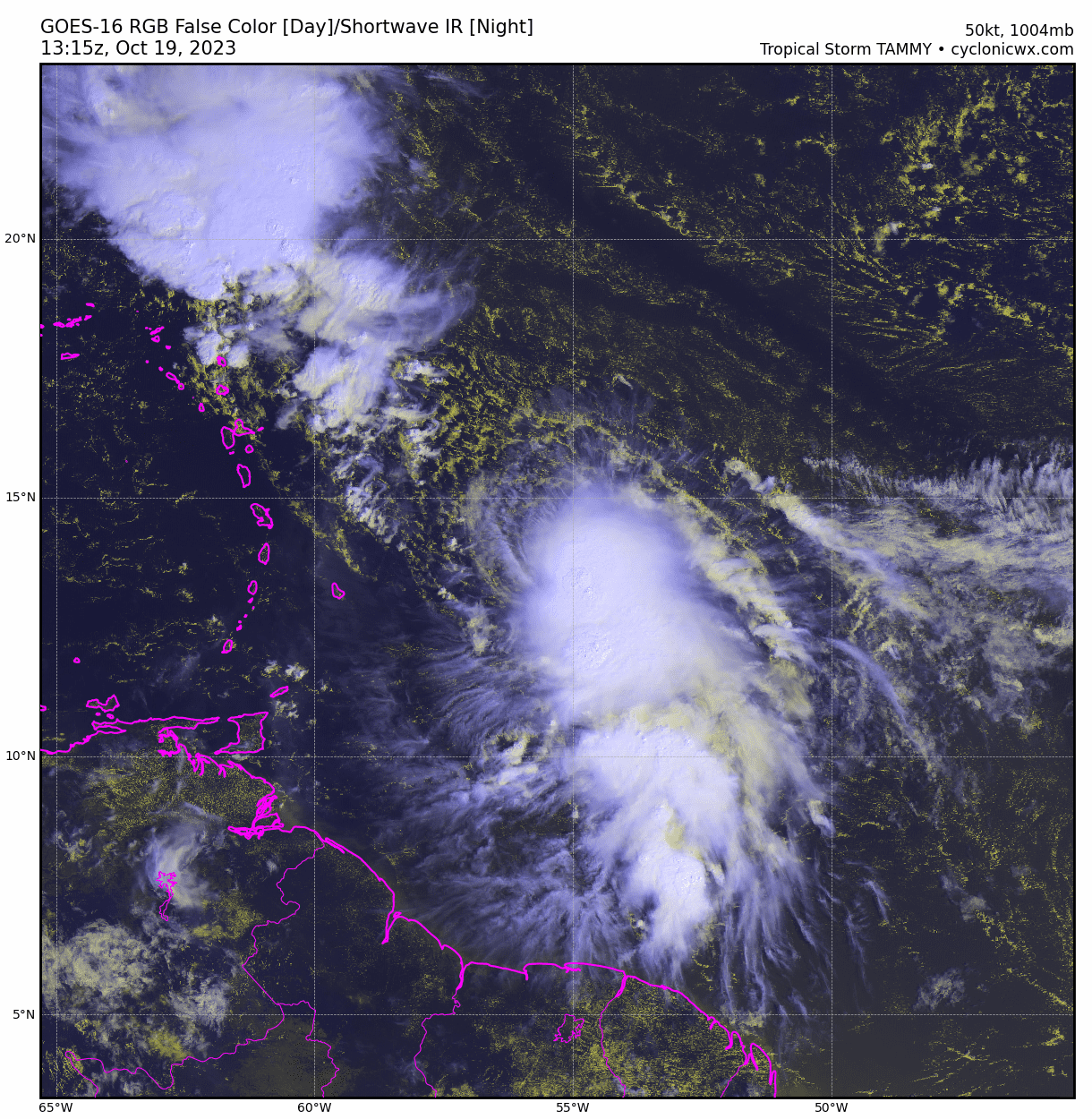
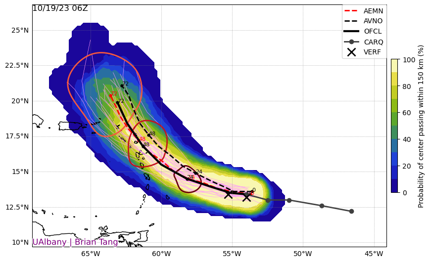
However, the Atlantic is not completely quiet, with newly developed Tropical Storm Tammy east of the Lesser Antilles becoming the 20th named storm of the 2023 hurricane season. As of the NHC’s Thursday morning 8 a.m. advisory, long-gestating Tammy is about 600 miles southeast of Puerto Rico, with maximum sustained winds of 60 mph. Tammy is moving west at around 15 mph, and on this track will move near or over the central and northern Windward Islands tomorrow.
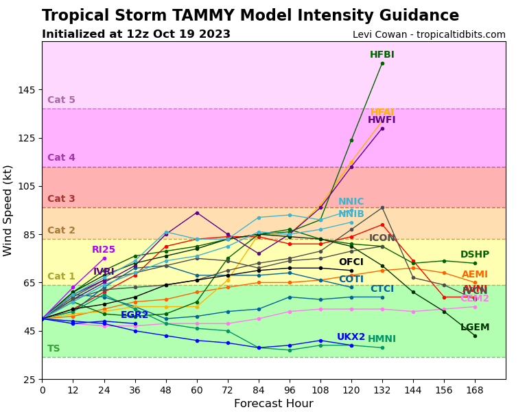
There is quite a bit of spread in how strong Tammy will get in the next few days, with model guidance ranging from a modest tropical storm to near-major hurricane intensity. Over the weekend, a dip in the jet stream should turn Tammy north a few hundred miles east of Puerto Rico, and then bring it into the open Atlantic next week. A stronger hurricane would make this turn earlier, while a weaker storm may make it farther west into the islands before angling north. Overall, given its healthy current appearance, Tammy has a good chance of becoming 2023’s seventh hurricane, and should be carefully monitored in the northern Lesser Antilles, Virgin Islands, and Puerto Rico, where heavy rain and some wind impacts are possible. No continental U.S. threat.
Development in the Tropical Atlantic east of the Lesser Antilles is quite rare after mid-October, last occurring as America’s Blockbusters became Chipotles in 2010, and fewer than 10 times in all since 1900. Typically, by the last third of October, elevated wind shear and rapidly cooling waters in the Main Development Region put an end to the Cape Verde season, but not in 2023. There is a silver lining to this: the strong mid-Atlantic ridging enabling Tammy to develop also promotes the trough keeping the Southeast cool and dry, and the Gulf and Caribbean unfavorable for tropical development. This general pattern will continue into the middle of next week, and the U.S. will be free of tropical threats until at least the final week of October.

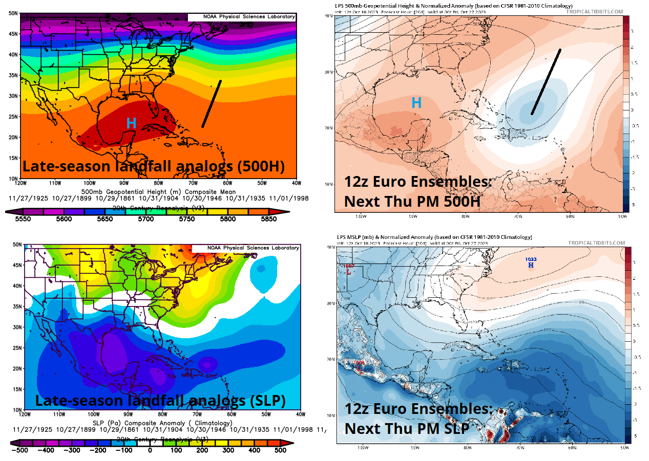
That is meaningful, because October 25th is an important milestone for two reasons. First, it is the date of the latest Category 3 or above hurricane landfall in Florida history, the Tarpon Springs hurricane of 1921. Second, climatological U.S. landfall rates fall so steeply beyond the 25th that there ought to be a runaway truck ramp at the bottom of it. With 97% of historical U.S. activity occurring prior to them, the last week of October and first week of November have just 25% of the landfalls of the previous two weeks. Only 19 tropical storms or hurricanes have made landfall in the continental U.S. after October 25th since 1900, so passing this date without further incident is an accomplishment.
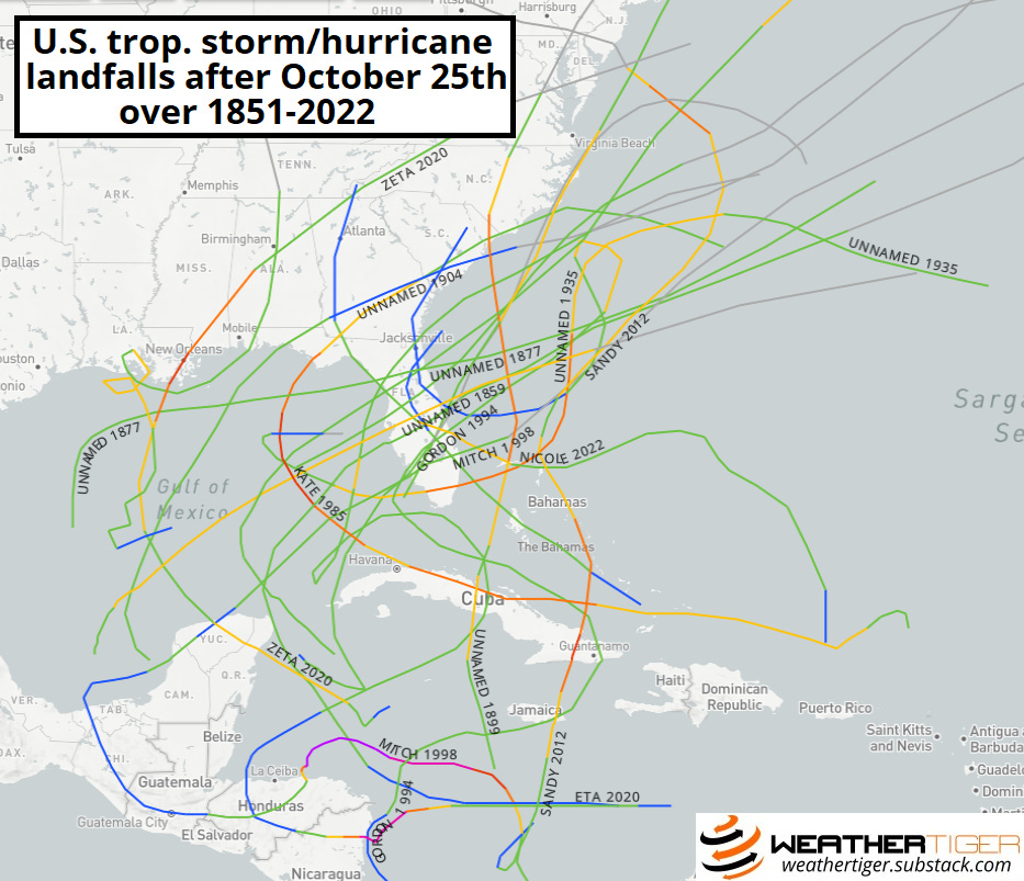
Yet every silver lining has a touch of grey. The majority of those 19 storms developed in the southeastern Gulf, western Caribbean, or southwestern Atlantic; looking at the general weather patterns four or five days prior to these landfalls, there tends to be a stout mid-level ridging extending from the Gulf to the Northeast U.S., with below-average sea-level pressures in the southern Gulf and Caribbean. Long-range ensemble guidance suggests a decent match to this pattern may take shape by the end of next week, so I’ll be keeping an eye on the Caribbean or Bahamas vicinity for a possible tropical system to slowly take shape towards the tail end of October. By no means does a late-season storm develop each time this pattern plays out, but it does suggest there is potential worth monitoring.
With luck, that scenario will not play out, allowing us to instead focus on key priorities like listening to the Shakira song with the werewolf howl, putting the finishing touches on our Krang costumes, and prank calling Congressional offices to propose alternate candidates for Speaker, like Werewolf Shakira and Krang. If so, next week’s column will be the final regularly scheduled one of the 2023 season. To celebrate, I’m inviting you to once again try your hand at stumping the Tiger by sending your burning hurricane questions to be answered in print next week. (The first two volumes of Stump the Tiger can be read here and here.) Please keep those queries on the zany side of lunatic fringe, and keep watching the skies.
Oh gee Ryan, Susan and I left SoFlo on Monday and are on the SW corner of Sint Maarten . . . thought the season was over. I searched today for St Martin hurricane history for the last half of October and could only find two. That means one of two things, it's not going to hit St Martin OR the law of averages is about to catch up. We will keep in touch as the storm goes by . . . hopefully 200+ miles east of us.
One more:
What does FEMA use to measure disaster recovery?