


Stump the Tiger: WeatherTiger's Weekly Column for October 29th
Ending regular season coverage of a quiet Tropics with a Q&A lightning round.

This week’s column is the final regularly scheduled article of the 2021 hurricane season for free subscribers; paid subscribers will receive weekly roundups through November. Free subscribers, I hope you have enjoyed our coverage this year, and you can look forward to receiving our 2021 season wrap-up at the end of November.
“Keep watching the skies.”
The last line of the 1951 B-movie “The Thing from Another World,” in addition to a prescient warning of the dangers of alien carnivorous plants, has closed five years of WeatherTiger missives. These words are there because they capture something of my philosophy on the riddles of the natural world, also approximated by the halfway point between Fox Mulder and Dana Katherine Scully.
Let’s face it: we don’t understand hurricanes. Not fully, not really. The science advances each year, but given the complexity of hurricanes, tropical weather will always have facets unknown and unknowable. When face-to-face with the vastness of the sky, the only move is to approach with humility, with respect, and, above all, with curiosity.

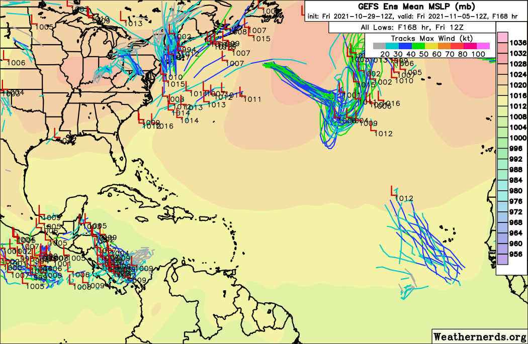
One thing that can be said with confidence is that hurricane season is winding down, with just 2% of U.S. landfall activity occurring in November. There is a moderate chance of subtropical development in the open Atlantic over the next 5 days, and a slight possibility of something firing in the southern Caribbean in 4 to 8 days. It’s worth monitoring the Caribbean as that is where the oddball roster of historical November threats originates, but if anything forms this week it would be more likely to continue west into Central America.
Anyhow, last week I asked for your curious questions. Time to teach the controversy, hurricane-style.
Q: Could you please explain the "ACE" contained in a hurricane season? I know it has something to do with the overall energy but what exactly is this energy? Where does it come from? How is it calculated? Is it static or does it vary by year and conditions and whatnot?
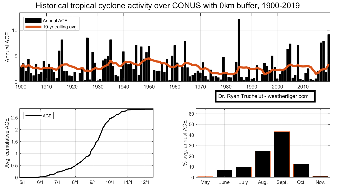
A: ACE stands for “Accumulated Cyclone Energy,” and is calculated by taking maximum sustained winds in knots, squaring, and dividing by 10,000. A minimal, 35-knot tropical storm produces about one-eighth of an ACE unit each six hours, while a 100-knot Category 3 hurricane produces one ACE unit in the same time.
Seasonal ACE sums all those individual pieces into an annual total. An average hurricane season comes in around 100 ACE units, but individual years vary greatly based on factors like ocean temperatures, El Nino status, and, yes, chance. Seasons since 2016 have dispensed ACE freely, averaging about 160 units, while 2013-15 clocked a mean of just 50 units.

Q: As I have observed land falling hurricanes in the central northern Gulf coast through the years I have recognized the reporting of maximum sustained winds from ground monitoring devices rarely if ever record sustained winds at the level reported by the National Weather Service. Gusts are even hard to find at the top hurricane strength. Please help us understand that observation.
A: Classifying tropical cyclones based on maximum wind speed reminds me of Winston Churchill’s quip about democracy: the worst form of government, except all the others. For a mature hurricane, the sustained wind reported in NHC advisories usually occurs only in a sliver of the eyewall, determined by exhaustive aircraft reconnaissance data.
Additionally, when a hurricane moves from the smooth ocean to rougher land, friction and turbulence slice at least 25% off top windspeeds. Thus, land-based wind observations are lower than the advisory intensity at landfall both because weather stations are too far apart to catch the highest winds, and also by nature of being located onshore.
Q: Years ago, when hurricanes hit and went inland, they seemed to lose strength quickly, usually within about 50-100 miles. Now, it seems that recent hurricanes are retaining their strength longer after they come ashore. Some are lasting hundreds of miles affecting two or three states before they weaken into storms or depressions. Even lower category 1 or 2 hurricanes appear to display this characteristic. What’s changed?
A: The inland destruction wrought by Harvey, Michael (see below), Laura, Ida, and others is historically unusual. These four storms have something in common: all rapidly intensified (strengthened by 30 knots or more in 24 hours) just prior to landfall. Controlling for a hurricane’s size, intensity, and forward speed, studies show a strengthening storm will deteriorate more slowly, and thus spread damaging winds further inland.
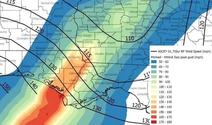
There are relatively few things in tropical meteorology that can be attributed to warming oceans and climate change with high confidence, but increased frequency of rapid intensification events is one of them. However, we don’t know if the recent spate of hurricanes rapidly intensifying up to landfall is the start of a climate-driven trend, or just extraordinarily bad luck. While the last six years have been wall-to-wall punishment, there is no long-term trend in U.S. landfalling ACE, and 2006 to 2015 was the calmest (luckiest?) decade for U.S. impacts since the 19th Century.
Thanks again to all who sent questions. That’s it for me other than a 2021 wrap-up when the season formally ends on November 30, unless an unexpected threat arises. I hope you found my forecasts useful and my dad-japery tolerable this year. Stay curious as you ponder the mysteries of this and other worlds, and keep watching the skies.