Potential Tropical Cyclone 4 Forecast for August 2nd
Potential Tropical Cyclone Four is expected to sweep across Florida starting tomorrow.
This forecast is outdated! Read WeatherTiger’s Saturday evening impacts forecast for Tropical Storm Debby here.
WeatherTiger’s Hurricane Watch is a reader-supported publication. Paid subscribers get Florida-focused daily tropical bulletins, plus weekly columns, full coverage of every hurricane threat, our real-time seasonal forecast, and the ability to comment on posts. If PTC 4 becomes more of a hurricane landfall threat to Florida, paid supporters will receive a subscriber-exclusive morning forecast briefing through the threat.
Don’t conepanic, but Florida is now beneath the first National Hurricane Center forecast track of the 2024 season. Potential Tropical Cyclone Four is forecast to sweep across the state between late Saturday and Monday, bringing heavy rain impacts to Florida. Significant uncertainty remains regarding the storm’s eventual fate.
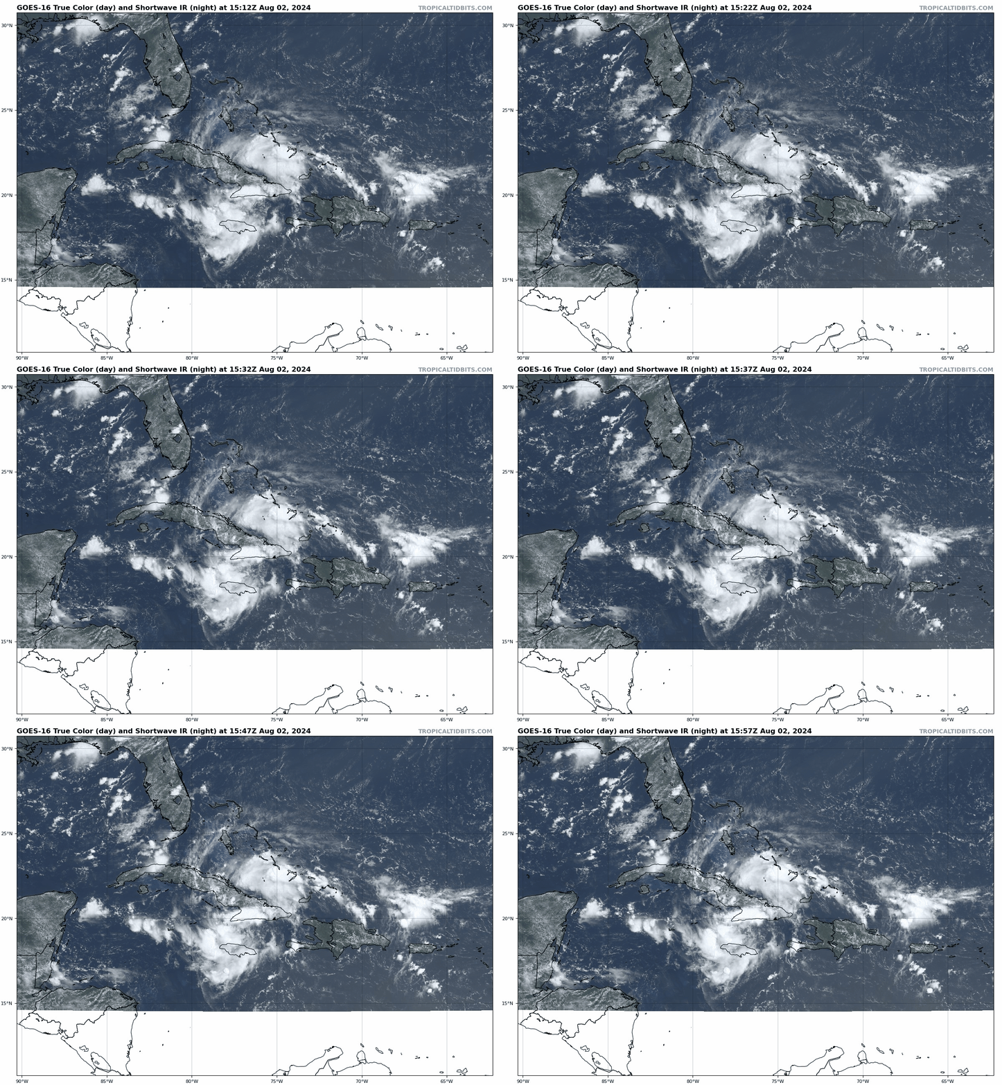
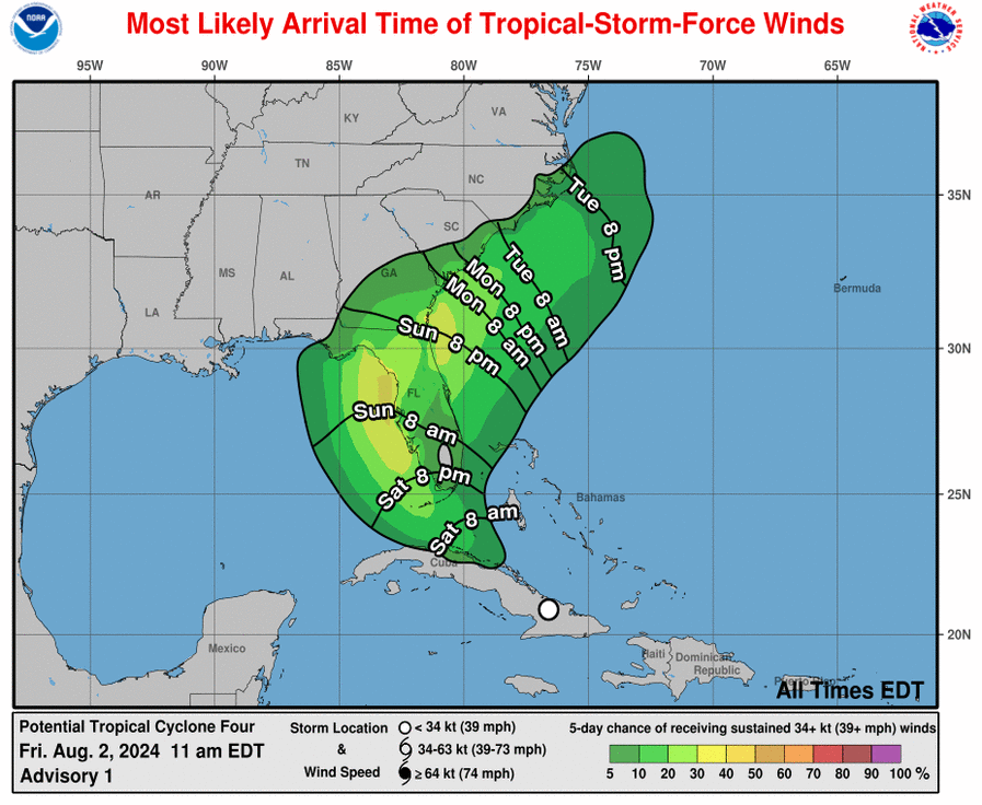
PTC 4, newly-designated as of 11 a.m. on Friday, is located near the southern coast of eastern Cuba, moving west-northwest at 16 mph. While the system is not yet organized enough to be called a tropical cyclone—that’s why we’ve got potential, rather than Tropical Depression Four or Tropical Storm Debby—the developing center of circulation has formed a little south of where yesterday’s models suggested it might. The first NHC forecast path brings PTC 4 into the Straits of Florida by mid-day Saturday, curves a tropical storm north towards the Nature Coast and eastern Big Bend by late Sunday, then slows it down near the Carolinas’ Atlantic coast midweek. Tropical Storm Warnings are now in effect for much of the Southwest Florida coast, with Tropical Storm Watches for the Keys and north to the Nature Coast.
In reality, there are two parts to the forecast for PTC 4: a shorter-term prognosis through Monday that is coming into a little better focus, and a longer-term outlook that remains riddled with doubt. In the first half of the forecast, the primary uncertainty has to do with land interaction with Cuba over the next day, which will result in the developing center of circulation consolidating somewhere between the Florida Keys and western Cuba by Saturday evening.
At that point, PTC 4 will turn north due to the influence of a dip in the upper-level jet stream over the eastern U.S.; models have been trending stronger with those south-to-north steering currents over the eastern Gulf since yesterday. If the center is closer to the Keys, the turn north will take PTC 4 through southwest Florida and up the Florida peninsula on Sunday, in which case it’ll likely be a depression or low-end tropical storm when crossing the coast. If the center is closer to western Cuba, PTC 4’s wider arc across the eastern Gulf will likely angle towards the Big Bend or central/eastern Panhandle on Monday. In that case, having an additional day over warm water and favorable outflow would boost probable landfall intensity into the moderate tropical storm to Category 1 hurricane range.
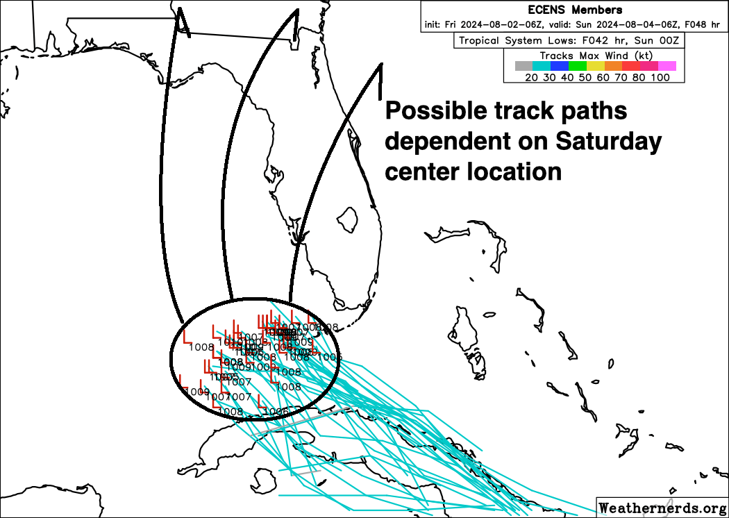
Thankfully, the trough is probably strong enough to bring PTC 4 inland over Florida by early Tuesday, even if the circulation starts out closer to western Cuba than the Keys. This is good because we (obviously) don’t want to see a stall close to the coast, not only because a near-shore stall would exacerbate flooding rain coverage, but because idle storms plus the 85-90F waters of the northeastern Gulf are the devil’s playthings. A Gulf stall track isn’t completely out of the realm of the possible, with some support on the Euro ensembles, but it’s less likely today than yesterday.
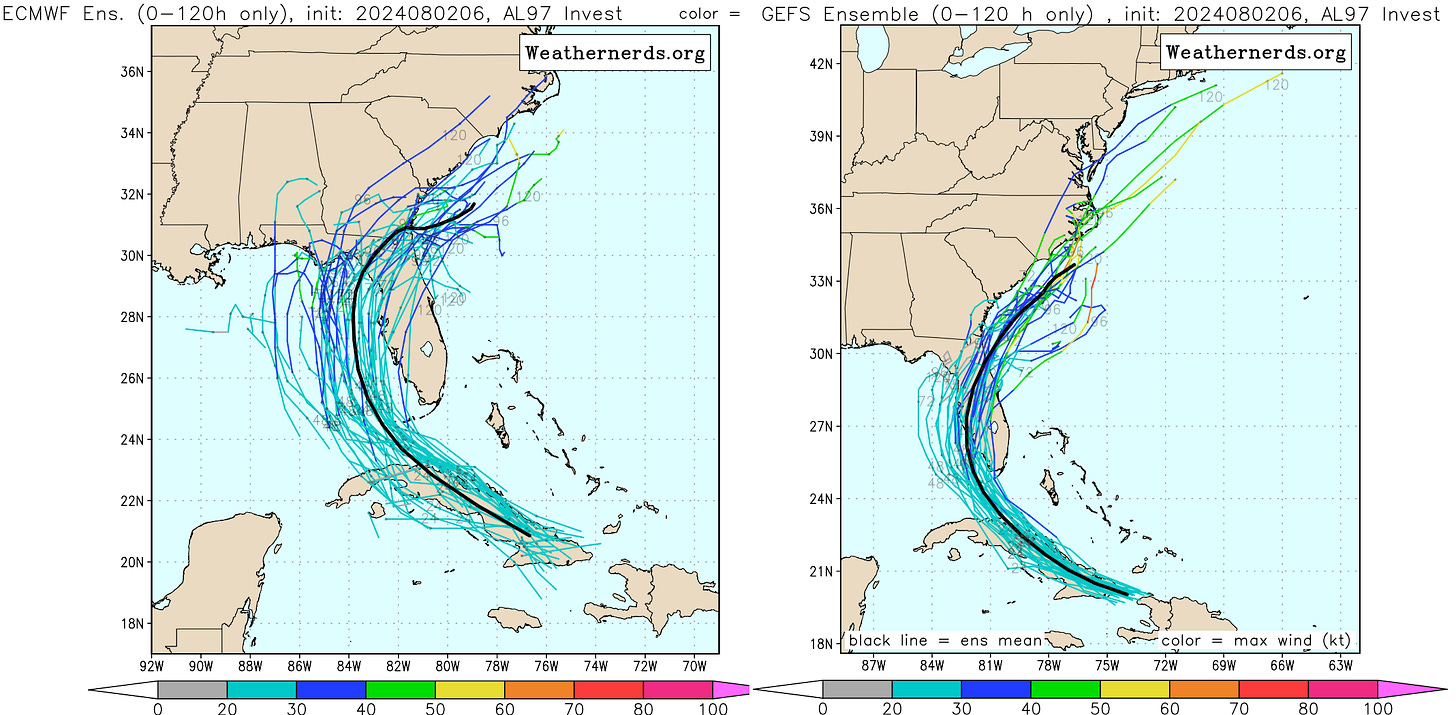
With that said, the fact that PTC 4’s incipient circulation is forming a bit south of expectations favors the scenario in which the storm has closer to two days over the Gulf rather than one. Thirty-six to forty-eight hours over the Gulf is enough to cause advanced mischief, and North Florida should be on alert at this point for a hurricane threat early next week. I’m not saying a hurricane will hit North Florida, but a farther west track with more time to intensify is well within the realm of the possible. This is definitely a case in which the NHC “cone of uncertainty” underestimates how uncertain the track forecast really is. We’ll have a better idea on the track trajectory and thus intensity upside on Saturday afternoon, once PTC 4 detangles from Cuba.
I’ll talk more about impacts once there’s more clarity, but for now, know that in both general scenarios, Central and South Florida can expect abundant rainfall between Saturday and Monday. Overall totals should be in the 3-6” range, with local accumulations up to 10”. Both scenarios also mean some tropical-storm-force wind gusts for the immediate peninsular Gulf Coast, but wind and surge impacts should be relatively modest overall in South and Central Florida either way.
In the Big Bend and Panhandle, there is a big difference in possible impacts between the east and west tracks. If PTC 4 moves over the peninsula on Sunday, there probably won’t be much (if any) rainfall west of Lake City, much less any notable wind or surge. Like a lot of Gulf systems, the western half of the storm should be much drier than the eastern (“dirty”) half. However, a track that arcs toward the Big Bend or Panhandle brings with it widespread heavy rainfall starting on Sunday, along with the possibility of more acute wind and surge threats near and east of wherever the center might track. It is too soon to put a finer point on the impact forecast than that, so stay tuned.
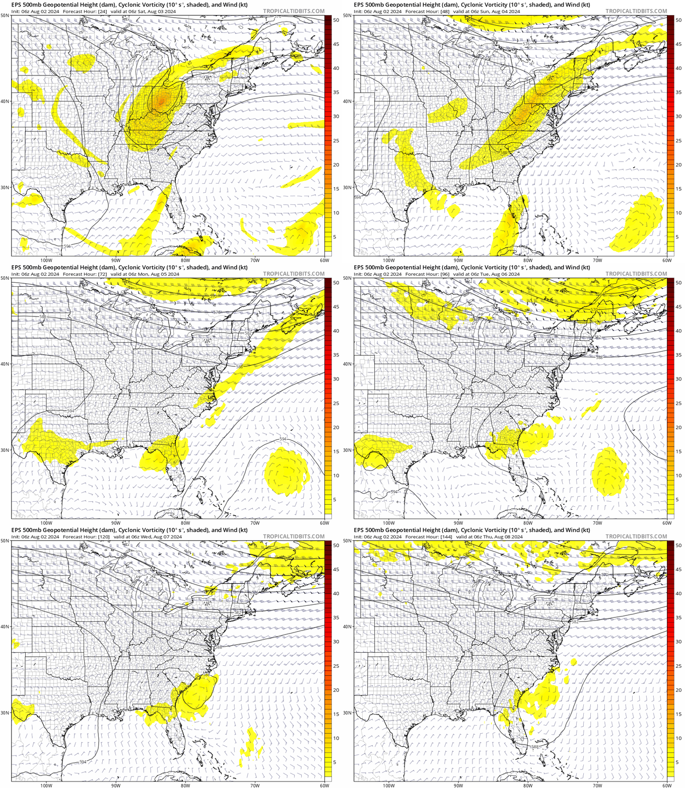
The long-term PTC 4 puzzle has to do with an expected collapse in steering winds starting on Tuesday. Global models are still hustling that eastern U.S. trough north and east in about five days, resulting in a region of minimal steering flow across the Gulf, Southeast U.S., and western Atlantic. Will PTC 4 be in the northeast Gulf, inland, or offshore near the Carolinas when that happens? The NHC’s initial wager is on the Carolinas, but as the NHC forecast discussion highlights, that may well change. In all honestly, there’s just no good answer to this question until at least a well-organized center of circulation forms. Even then, tropical cyclone forecasts in a weak steering flow environment have higher errors and lower confidence average. Expect the unexpected.
Prolonged periods of slow or no motion also are situations in which flooding rainfall, even well inland, become a primary hazard. With PTC 4 probably lingering somewhere near or over the Southeastern U.S. into late next week, Florida, Georgia, and the Carolinas should be on alert for a flash flooding and river flooding threat. There’s also the possibility of mid-week strengthening if the storm makes it offshore south of the Carolinas, but that is a problem for another day.
Overall, a potential Tropical Storm Debby will at the very least be a downer for Florida’s weather this weekend, spreading heavy rainfall over the peninsula and possibly the Panhandle through Monday. The eastern Panhandle and Big Bend coasts also need to monitor PTC 4’s progress closely as the forecast evolves. In the meantime, keep your wits about you, don’t panic, and keep watching the skies.
Next update: Tomorrow afternoon.


![[Image of U.S. rainfall potential] [Image of U.S. rainfall potential]](https://substackcdn.com/image/fetch/w_1456,c_limit,f_auto,q_auto:good,fl_lossy/https%3A%2F%2Fsubstack-post-media.s3.amazonaws.com%2Fpublic%2Fimages%2Fc72b682f-ef21-45f1-9e36-81e8a4f48453_892x716.gif)
Sorry you have to work the weekend but I am so glad you are here.
Is this the first time there’s ever been a probability cone for something that’s not a tropical storm? PTC is new to me! Ever since Aculpulco I fear rapid intensification every time I hear “tropical storm”. You have said that RI is difficult to predict…do you see anything like that happening with this storm?