Hitting Close to Home: Hurricane Watch Weekly Column for June 5th
A look at potential activity mid-month and a dive into June's colorful hurricane history.
WeatherTiger’s Hurricane Watch is a reader-supported publication. Paid subscribers get Florida-focused daily tropical briefings, plus weekly columns, full coverage of every hurricane threat, our exclusive real-time seasonal forecast model, and the ability to comment and ask questions for $49.99 per year.
In the words of Lao Tzu and the piano riffs of Vanessa Carlton, a walk of a thousand miles begins with a single step. Thankfully, our 2024 hurricane season journey has begun at a measured pace, with the first week of June lacking any notable disturbances in the Atlantic, Caribbean, or Gulf. The Tropics remain quiet today, with no credible indication of a near-term threat.
Still, June is a time of change in nature. Jeeps shed their doors, awkward teenage geese learn how to block sidewalks, and following suit, a dry Gulf Coast weather pattern is likely to soon shift. Caribbean moisture will stream north by Tuesday, enhancing Florida’s rainfall chances for the remainder of the week. While upper-level winds initially will not be supportive of tropical organization, that becomes less true with time, especially if convection festers over the Gulf into late next week or beyond. This set-up is messy and there’s nothing to watch yet, but the slow development of a wet, sprawling tropical system in the third week of June would not be a surprise.

That scenario is, in fact, common at this time of year. Let’s learn from the past as we keep an observant eye on the present with this first entry in a six-part guided tour of the how, why, and huh? of hurricane history. First up: June, a month an ancient mariners’ rhyme belittles as “too soon” for storms, though the facts say otherwise.

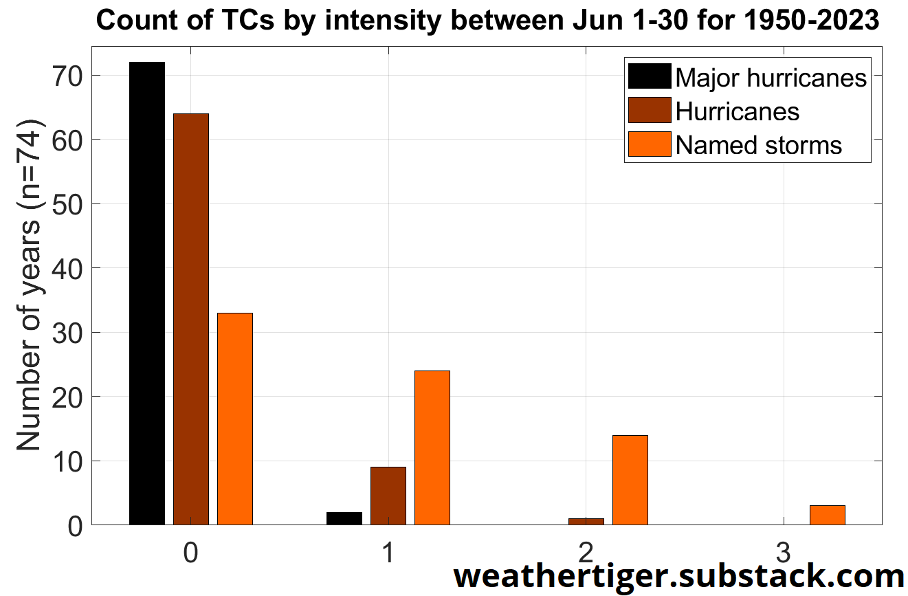
By the numbers: If hurricane season is a George Foreman grill, June is the bun-warming lid: it heats things up, but doesn’t get into the meat of the situation. June accounts for a scant 2% of historical Atlantic tropical cyclone activity, but punches above weight at 7% of U.S. landfall activity— about equal to July, and three times more than November. Since 1950, a little more than half of seasons have had at least one named storm develop in June. However, there are only about 15% and 2% odds of a hurricane or major hurricane, respectively.

While top shelf intensity is out-of-reach, June has far and away the highest proportion of impacts relative to total activity. Nearly 20% of June Atlantic storm energy occurs within 30 miles of the continental U.S., four times the ratio of the August-October peak of hurricane season. Florida alone snags about 7% of total June storm activity, well above the 2% baseline for all other months.

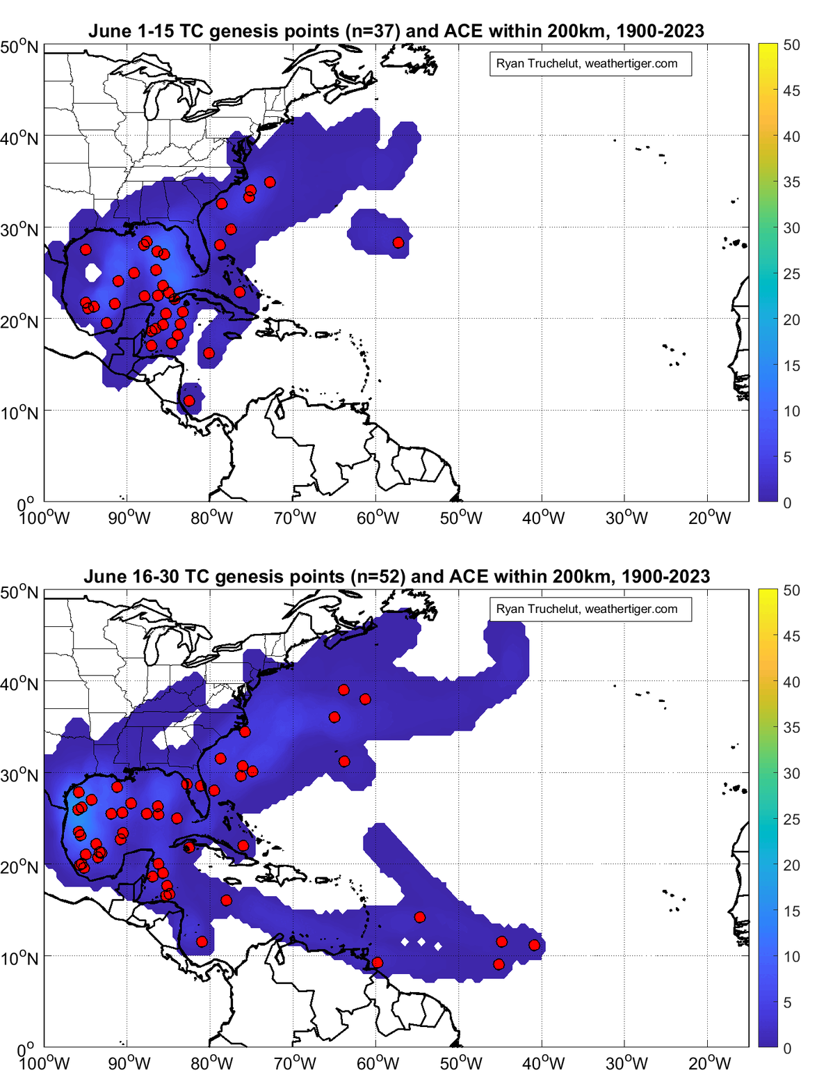
Where do they come from? As hinted above, the storm formation call is often coming from inside the house. In the first half of June, most named system development points are clustered close to land in the northwestern Caribbean and eastern Gulf of Mexico. The palette of the second half of the month is a little more expansive, with storm formation becoming more common in the western Gulf and still possible in the Caribbean and southwestern Atlantic. A smattering of depressions and storms have also formed east of the Lesser Antilles in late June, including a record two in 2023.

Where are they going? The Gulf Coast is in the climatological crosshairs, with a named storm landfall occurring every two to three years on average. The eastern Gulf Coast is the clear “winner” in the first half of June, with early season storms showing a curious proclivity for slogging ashore near the crab-catching paradise of Steinhatchee in Florida’s Big Bend. Steinhatchee Specials remain a possibility in the second half of June, but a greater percentage of landfalls shift west towards Texas due to changes in steering currents. Note that of the 20 June U.S. hurricane landfalls since 1851, 90% occurred after June 15.
Heavy hitters and worst-case scenarios: June’s sole major hurricane landfall is 1957’s Hurricane Audrey and the most recent U.S. hurricane strike is 1986’s Bonnie, so it’s been a minute since June meted out more than light punishment from a wind perspective. However, the most destructive historical June hurricane wasn’t a hurricane at all, but rather 2001’s Tropical Storm Allison. Allison parked for nearly a week over eastern Texas, inundating the Houston metro with 10-40” of rainfall, and causing 41 deaths and $16 billion in damage.
A close second is 1972’s Agnes, with northeastern U.S. flooding accounting for most of its $15.5 billion price tag despite an initial Category 1 landfall near Panama City. June hurricanes also hit Florida in 1906, 1945, and 1966, but the real high-water mark came under the cruel tutelage of Grover Cleveland in 1886. That June, three Category 2 hurricanes hammered the Gulf Coast in as many weeks, including twins striking the Panhandle on June 21 and June 30.
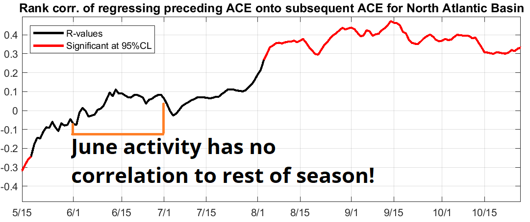
What it means: Really, not a lot. Like the symbolism of Lost, tropical activity in the first two months of hurricane season is best not overinterpreted. June storms tell us zip, zero, and bupkis about peak season U.S. landfall risks to come. Still, the opening act is a reminder that the human impacts of tropical cyclones are not necessarily tied to maximum winds; freshwater and flash flooding can be an equally if not more deadly and destructive threat.
By some measures, June is an incrementally gentler month. Average Florida high temperatures are a tasteful low-90s relative to the harsh mid-90s to come, destructive hurricane landfalls are rare, and young geese have not yet come into their full powers of obnoxiousness. With all Floridians enjoying sensational summer savings on disaster supplies through June 14, use that goose grace to put your hurricane plans and kits together, and as always keep watching the skies.


Thanks for Vanessa - I especially like the gratuitous owl on the piano! A very pleasant voice…
Tillman
ps. Welcome back😁