WeatherTiger's Atlantic Hurricane Season Outlook for August 2022
It's a little too quiet in the Atlantic. Our real-time model suggests that won't last forever.
If you enjoy this outlook, consider supporting WeatherTiger’s Hurricane Watch by signing up for our comprehensive coverage of what looks to be a busy 2022 season. Paid subscribers get Florida-focused daily tropical briefings, weekly columns, full forecasts of every U.S. hurricane threat, and our real-time seasonal hurricane outlook for $7.99/month or $49.99/year.
So far, the 2022 Atlantic hurricane season has been quiet. Perhaps, a chiaroscuro film noir detective might think to himself over a liquid lunch, a little too quiet.
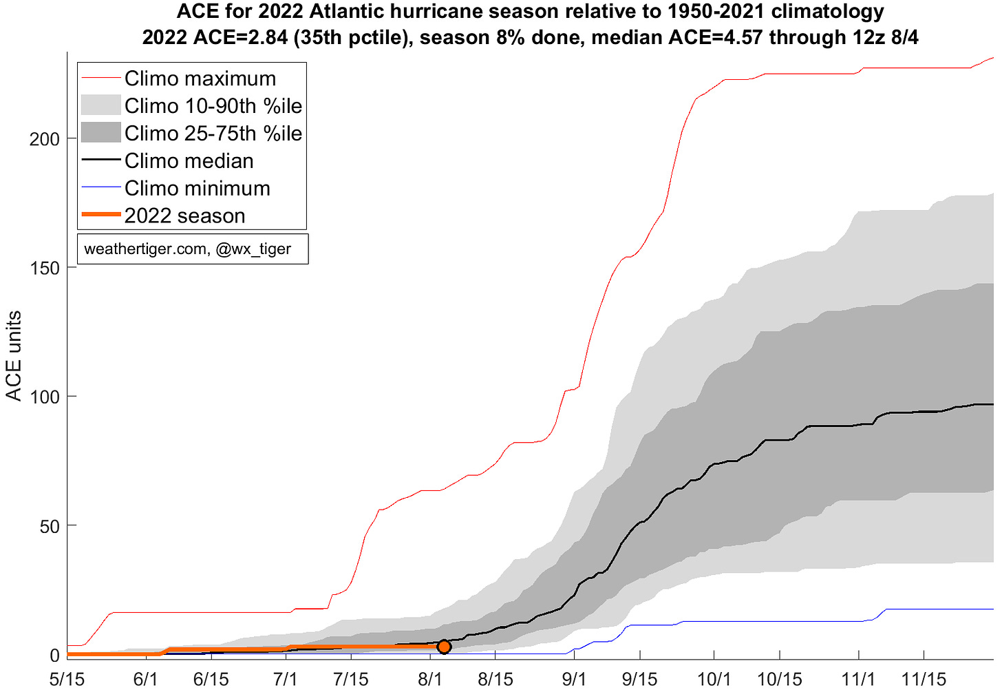
This perception is accurate. The three tropical storms that have developed this year have scraped together fewer than three units of Accumulated Cyclone Energy (ACE) to their forgettable names, less activity to date than two-thirds of all hurricane seasons since 1950. Of these, only the shambolic Colin impacted the continental U.S. as a named system. Planet Earth has had 99 problems this summer, but a busy June and July in the Atlantic hasn’t been one.
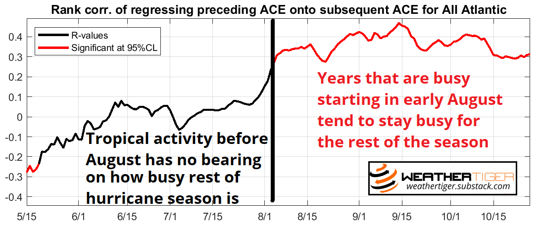
However, when it comes to the first third of hurricane season, past performance does not predict future results. Unfortunately, there is not a statistically significant relationship between tropical activity prior to early August and how busy the rest of the season turns out to be. In fact, the correlation is zero: all else equal, busy starts to hurricane season have equal chances of petering out or continuing, and so do languid summers like 2022.
This is because the historical distribution of hurricane activity is strongly peaked about the September 10th midpoint of the season, and thus we’re about to be running up a hill that even Kate Bush would deem formidable. Between early August and mid-September, average daily ACE rises eightfold. With over 80% of U.S. landfall risks ahead, what matters going forward is whether favorable conditions for hurricane development will exist during the busiest 8 weeks of the season from mid-August to mid-October.

This window is active as it is when low-level instability, mid-level moisture, and upper-level wind conditions align to support storm development over the Atlantic’s Main Development Region, stretching from West Africa into the Caribbean. WeatherTiger’s real-time seasonal forecasting algorithm takes the most reliable historical predictors of how the peak season environment will shake out into account, and has projected a busier than normal hurricane season in daily updates through the spring and summer.
With a new batch of data just in to WeatherTiger World HQ, the latest run of our seasonal forecast model remains in-line with those expectations. We project a most likely outcome of around 160 ACE, about 50% above the average of 100 ACE units over the past 50 years. This forecast remains halfway between the total activity observed during the hyperactive 2020 (180 ACE) and above-average 2021 (145 ACE) hurricane seasons.
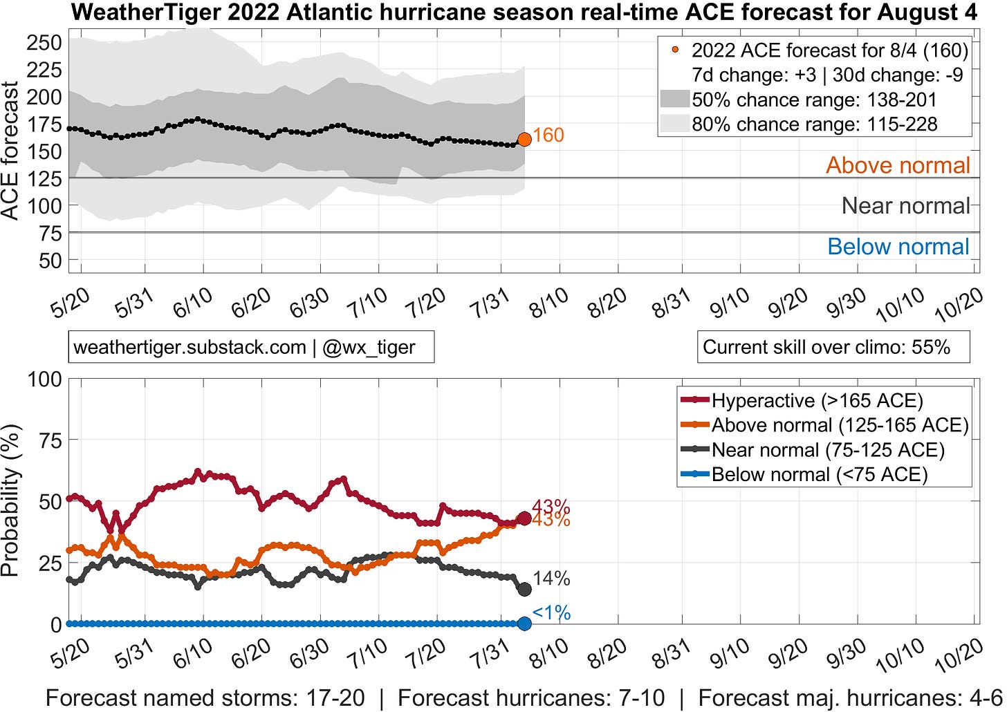
Based on our model’s prior forecast errors, there is a 50% chance of 2022 total Atlantic activity landing in the 140-200 ACE unit, 17-20 named storm, 7-10 hurricane, and 4-6 major hurricane ranges. That corresponds to around 40% chances each of a hyperactive (165+ ACE) or merely above average (125-165 ACE) season, with 20% odds of a near normal year. These odds will continue to shift as the peak approaches, and you can monitor WeatherTiger’s daily ACE model runs in real-time here.
This is only an incremental adjustment lower to our late May forecast, reflecting that the assumptions of our earlier predictions have played out as expected over summer. Most of the slate of leading indicators, including June and July sea surface temperatures (SSTs) in the Atlantic and Pacific, lower-atmospheric temperatures, and tropical trade wind strength, point to favorable conditions for Atlantic hurricanes during the peak season.

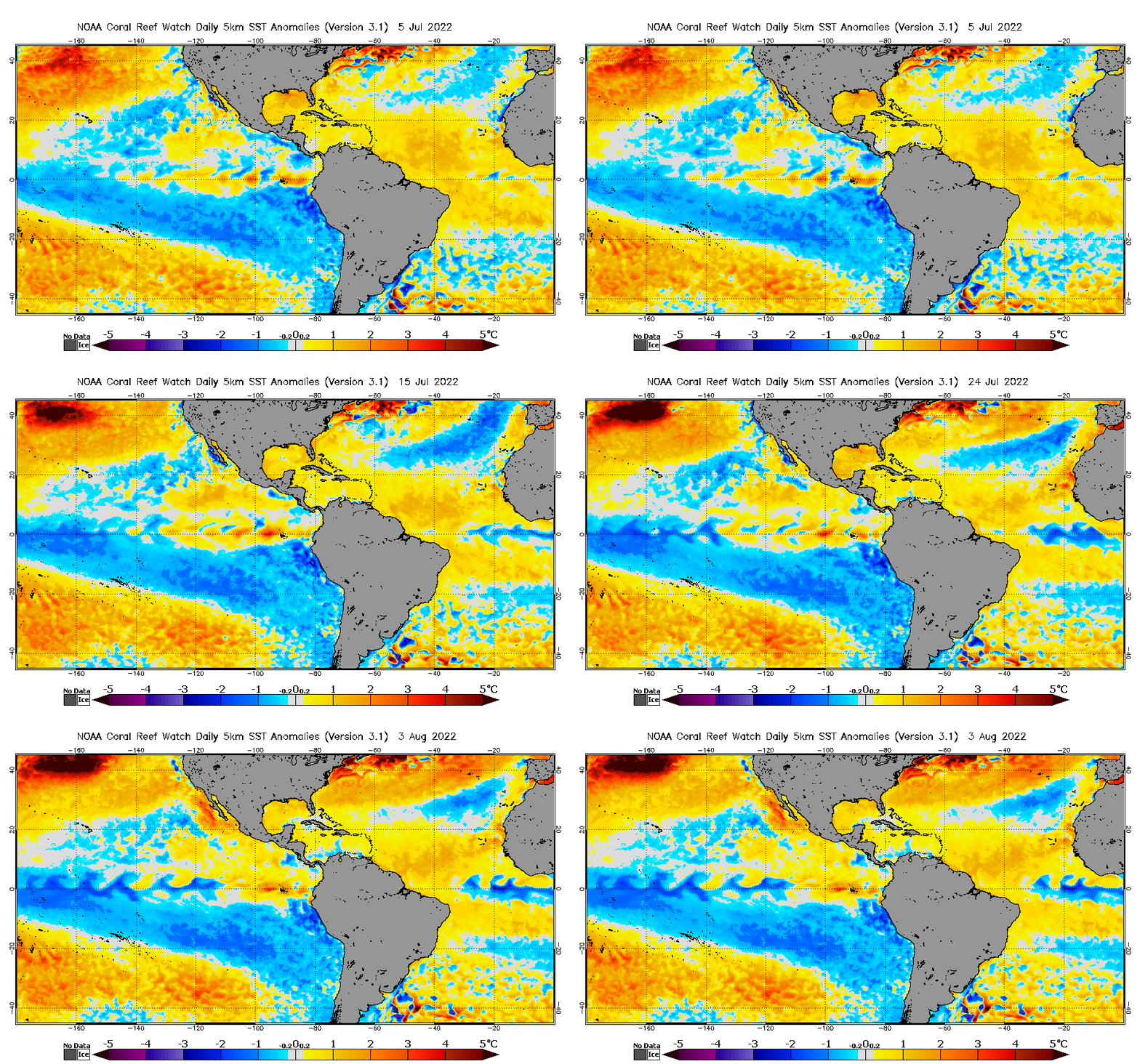
The first key to the forecast is the ongoing re-intensification of the endless La Niña event that, like certain viruses, has been refusing to take a freakin’ hint and vamoose since 2020. The central Equatorial Pacific waters moderated a bit towards normal over the summer as expected, but are cooling once again heading into fall. Updated projections including WeatherTiger’s own El Niño/La Niña model show a strong consensus for the return of moderate La Niña conditions by September or October. That’s not good news, as Atlantic seasons during a La Niña tend to be more active, and also stay busy deeper into the fall due to a reduction in hurricane-hindering wind shear. El Niño/La Niña forecast uncertainty is also much diminished in August vis-à-vis May, so we’re very likely stuck with La Niña, variant BA∞, into early 2023.
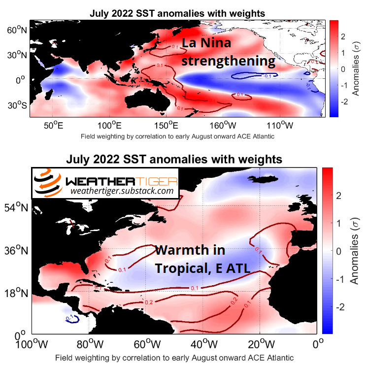
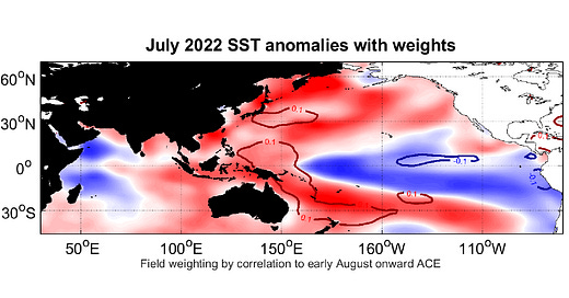
Atlantic SST anomalies matter as well. While early summer ocean temperatures languished a bit, there has been a notable warming of the Atlantic’s Main Development Region in the last two weeks, concentrated in the areas of the eastern Atlantic and Caribbean shown above to have the strongest historical relationship with future hurricane activity (above). Overall, mean July SST anomalies were above normal in the Gulf, across the Main Development Region, and northeast to western Europe. This hook of warmth closely matches the regions with the strongest historical relationship between warm water in July and an active hurricane reason. For the kids in the back of the class: this is not a good sign, though at least current water temps where it counts are less eye-popping than in hyperactive seasons like 2017 and 2020.
Atmospheric leading indicators are a little more of a mixed bag, hinting that 2022 probably isn’t on course for a 2020-style fire sale. Average air temperatures in July over the lowest 10,000 feet of the atmosphere in portions of the western Pacific near Australia are an important predictor in WeatherTiger’s seasonal model, as these regions give hints to future trends in El Niño or La Niña trajectory. In 2022, these areas were blazing hot, confirming the signal for a stronger La Niña into the fall. Warm air temps over the tropical and subtropical Atlantic also indicate the potential for incipient MDR warming.

On the other hand, relatively brisk east-to-west tropical trade winds across the central Atlantic and Caribbean in July suggest a somewhat more typical hurricane season. When these trade winds are stronger, tropical waves experience more unfavorable wind shear conditions, which has been a prime factor keeping the Atlantic quiet this July. As strong summer trades often last into fall, this is historically a predictor of August-October hurricane activity.
While July 2022’s modestly stronger than normal easterlies occupy a region where such winds usually mean lower future ACE, the shift back towards La Niña in the Pacific will probably lead to a slackening of these trades in the next few weeks to months. Still, this is one indication that the Atlantic will not quite be firing on all cylinders this year, at least for the near future, and accounts for our slight reduction in forecast activity. Colorado State and NOAA seasonal outlooks, also hot off the press, have also come down slightly from their June forecasts but remain well above average.
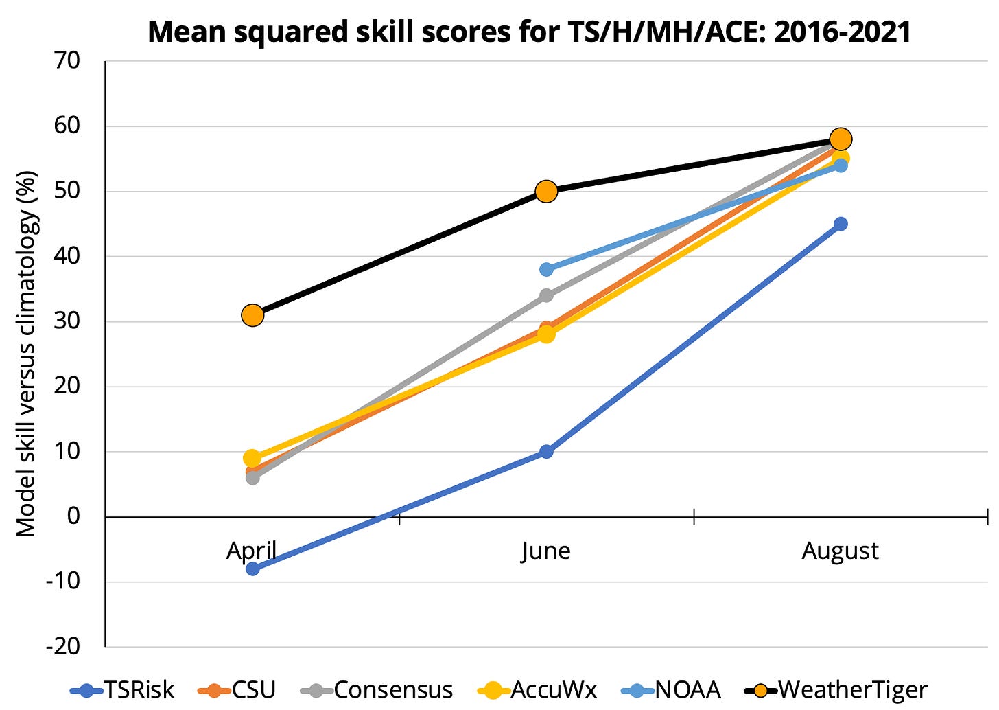
Overall, these oceanic and atmospheric conditions are solid predictors of peak season hurricane activity, with WeatherTiger’s model notching forecast skill for August seasonal outlooks since 2016 of over 50%, as seen below. This means the error of our recent forecasts is less than half of simply predicting average activity, similar to or a little lower than August predictions from other forecast groups. Our 2020 and 2021 August outlooks were both accurate to within a few units of ACE, though I’ll be the first to point out that such precision is a combination of some skill and a lot of luck.
What does this mean for U.S. impacts? Well, it’s not 2020 all over again (probably), but at least a couple of U.S. hurricane landfalls are more likely than not in 2022 given the expected amount of activity. Steering patterns heading into peak season are always a tough forecast, but I’ll dig in on what can be said about where hurricanes might be disposed to track this year in part II of WeatherTiger’s August outlook next week.
Overall, despite a quiet summer, Hurricane Season 2022 is still expected to be busy in the Tropics. I advise you to prepare your hurricane kits and plans right now while things remain disconcertingly calm, and, as always, to keep watching the skies.

