2022 Atlantic Hurricane Season Outlook
Introducing WeatherTiger's real-time seasonal model, predicting high chances of a busy year.
If you enjoy this free outlook, please consider supporting WeatherTiger’s Hurricane Watch by signing up for our comprehensive coverage of what looks to be a busy 2022 hurricane season. Premium subscribers get Florida-focused daily tropical briefings, weekly columns, full coverage of every U.S. hurricane threat, and expanded seasonal outlooks, all for $7.99 per month. Free subscribers receive our weekly newsletters.
To paraphrase Yogi Berra, it’s hard to make predictions, especially about the future. Consider the millions of hours of Imagineering that went into EPCOT Center, and then consider the only thing they got right about the future was the high cost of food.
Of late, forecasting Atlantic hurricane seasons has fallen into a predictable groove, with only fools betting against elevated activity. It chagrins but does not surprise me to say that WeatherTiger’s updated projection for the 2022 season once again calls for a busy year, with net activity about 60% higher than a typical season. Should this play out, 2022 would be the seventh-consecutive above normal year.
Yet, forecasting teaches humility, and a confident prediction deserves all the more scrutiny. With humanity committing classic blunders left and right in 2022 like starting land wars in/near Asia, is it possible that the conventional wisdom on the upcoming season is wrong?
While there are few hints to that end from our or other guidance, WeatherTiger is rolling out a major model upgrade this year designed to give an early heads-up on any swerves in seasonal expectations. More on that in a bit.
First, a quick orientation for new readers. I’m Dr. Ryan Truchelut, Chief Meteorologist at WeatherTiger, a weather analytics and forensic meteorology company. I have a doctorate in meteorology from Florida State and over 15 years of tropical forecasting and research experience. I’ve been providing scientific commentary and dad humor for the USA Today Florida Network for six years and here at the ‘Watch for two years, with nary a quiet season yet to the WeatherTiger name. Look for a column each Wednesday through October, with more frequent forecasts as the situation warrants.
As implied, I’m also the dad of a three- and a five-year-old. Therefore, the only thing I want more than my children to someday experience a normal hurricane season is for Facebook to not exist in five years, the greatest hope of all parents.
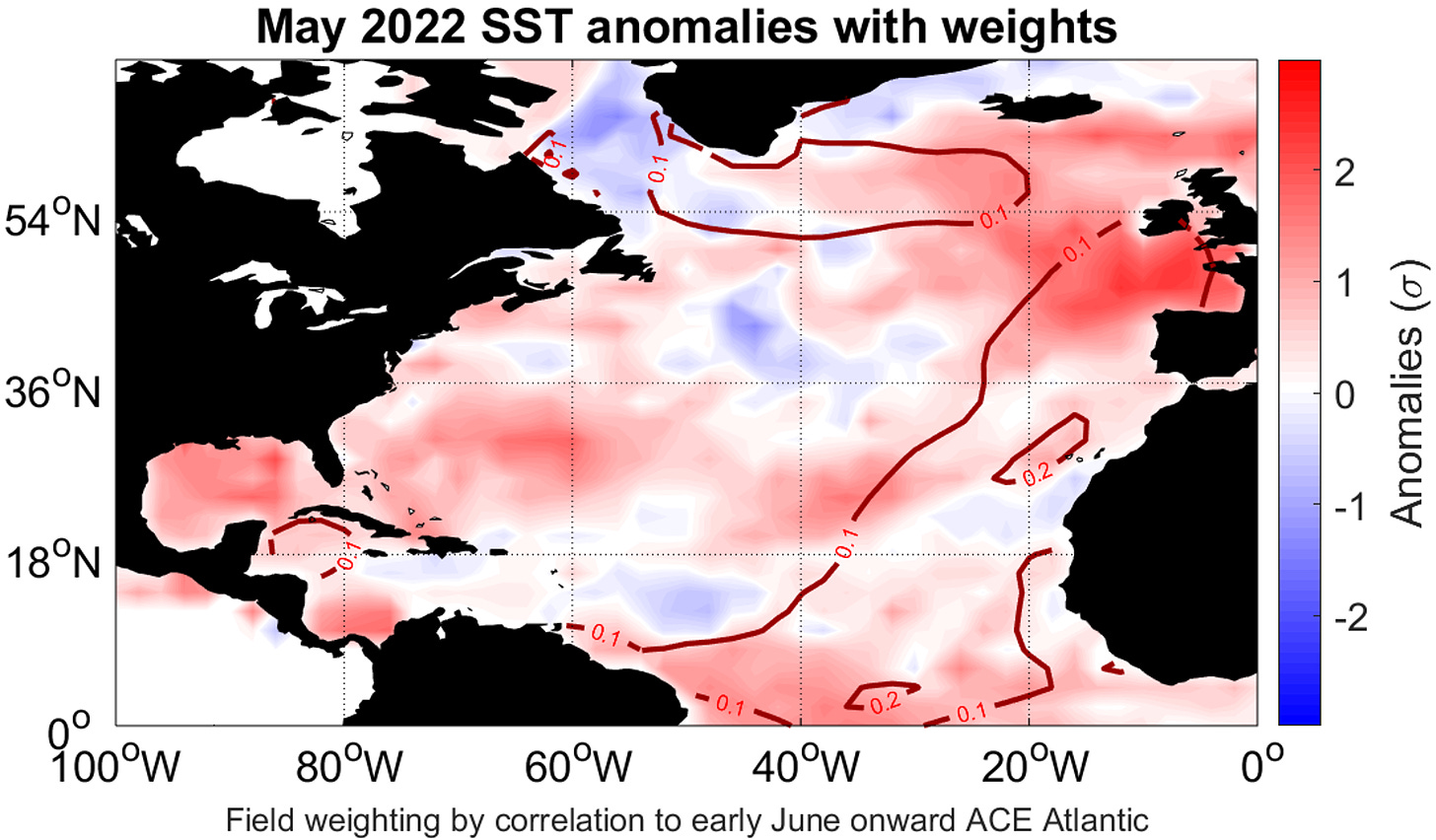
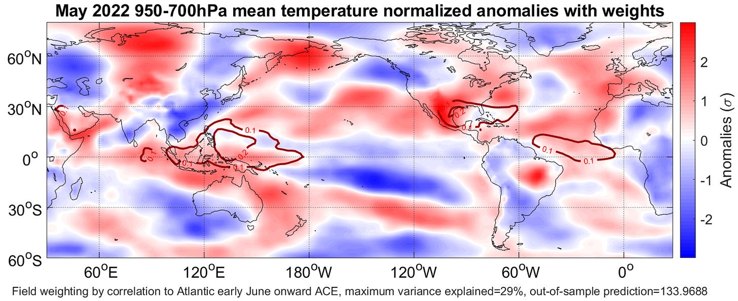
Sadly, the bullish fundamentals underpinning our outlook are unchanged since April, with trends in reliable predictors necessitating a slight upward revision to our spring forecast numbers. Over the course of May, Atlantic sea surface temperatures (SSTs) have taken on a look more reminiscent of the warm phase of the Atlantic Multidecadal Oscillation. This meathook of warmer than average waters arching from Brazil to Europe to Greenland tends to presage busy seasons, especially if it persists through summer. The oceanic signal is confirmed by robust spring heat in the lower atmosphere over the eastern Atlantic.
May temperature anomalies near Southeast Asia are another key predictor. Warmth there, as the case this spring, indicates a pattern of sinking air over the eastern Pacific and rising air over Africa is likely to set up this summer, boosting Atlantic SSTs and the convective potential of tropical waves. Expect continued warming of the Atlantic’s Main Development Region (MDR) for at least the next two or three weeks.
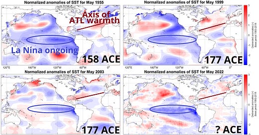
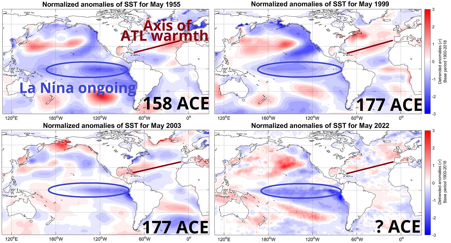
The waters of the equatorial Pacific remain around 1°C cooler than average. This indicates an ongoing La Nina, which is linked with less vertical wind shear in the Caribbean, Gulf, and western Atlantic. Wind shear weakens hurricanes, so La Nina-influenced seasons tend to be more active and destructive than their El Nino or neutral counterparts. WeatherTiger’s latest modeling indicates a moderating trend in the Pacific into July, but not enough to forestall a third consecutive summer of La Nina or dent Atlantic tropical expectations.
Weighting the May predictors that have the strongest relationship with storm energy in the following season, the top analogs for 2022 are a triad of active years: 1955, 1999, and 2003. In each, cool-neutral or La Nina conditions were present in the Pacific, and a band of warm subtropical waters later merged with Equatorial Atlantic warmth over the MDR, leading to favorable SSTs for the peak season. Average Accumulated Cyclone Energy (ACE) in these three years was 170, which agrees with our quantitative projection.
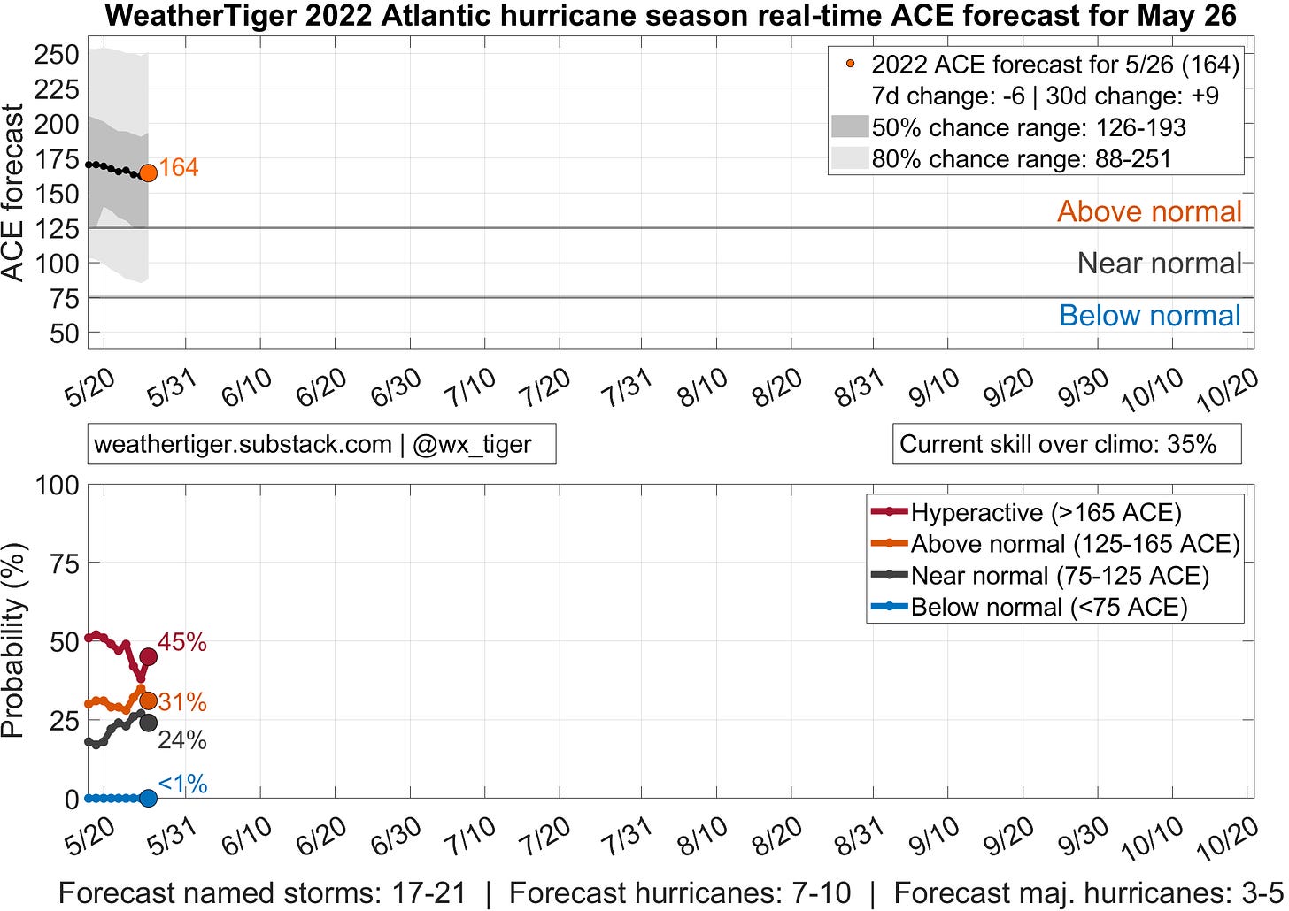
Using an ensemble of models with May SSTs, low-level temperatures, and a few other herbs and spices as forecast inputs, WeatherTiger’s most likely outcome for 2022 season is 160-165 units of ACE, versus an average of 100 units since 1970. There is a 50% chance of the season ending within the ranges of 125-190 ACE units, 17-21 named storms, 7-10 hurricanes, and 3-5 major hurricanes. The odds of a below normal, near normal, above normal, and hyperactive hurricane season, respectively, are less than 5%, 25%, 35%, and 40%.
None of these numbers are set in stone. As the ocean and atmosphere continuously evolve, so do the probabilities of various hurricane season scenarios. Sometimes, as in 2017, an innocuous spring pattern turns alarming over the summer; other years, like 2013, see early prospects for elevated activity shrivel into the season’s peak. The steepest changes in key predictors often occur from June through early August, a timeframe in which there has historically been a one- or two-month gap between seasonal forecasts.
No longer. For the 2022 hurricane season, WeatherTiger is debuting the first real-time seasonal hurricane model. Basically, if there was one seasonal forecast Jack Bauer or Chloe O’Brian would follow, it’s this one. Each day, our model will account for the latest changes in the leading indicators of Atlantic seasonal activity, giving an updated perspective on how much total ACE is expected and odds of the season slotting into below, near, above, or well above normal ranges.
While day-to-day changes should be modest, over time the live model will function as an early warning system for notable shifts in expected activity, as well as folding in new information about previous and ongoing storms. I’ll be weaving output from the real-time model into this year’s columns, as well as publishing the projections daily.
I wouldn’t call it necessary to check our seasonal forecast each day, but if you’d like to add it to your quotidian regimen of seeing whether your house’s Zestimate has increased by $54 and if Nate Silver has lowered the chances of the Dolphins winning the Super Bowl from 0.02% to 0.01%, you are welcome to do so. If you don’t like the forecast, well, check back tomorrow.
Some things in life are eminently predictable, like death, taxes, and the actual value of a JPEG of a moose smoking a cigarette being zero. Others, like hurricane season, are more difficult to predict—or should be. WeatherTiger’s forecast is currently calling for yet another active season, possibly one splitting the difference between the frenetic hyperactivity of 2020 and the more reasonably busy outcome of 2021.
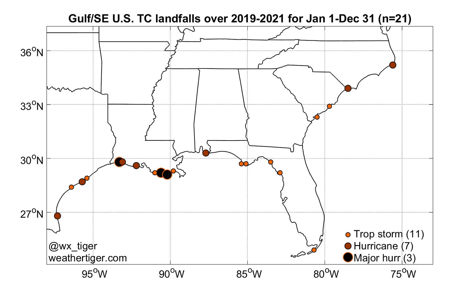
However, active years can have modest impacts, and vice versa. Despite busy seasons, no hurricanes have made landfall in Florida since 2018. More shockingly, no hurricanes have moved directly across the South Florida metro area since Wilma in 2005, when iPod clickwheel noise was still deafening. Florida’s relative good fortune in the face of hurricane onslaughts elsewhere engenders an unscientific yet pervasive sense that Something Worse Is Coming.
Is something worse coming in 2022? We don’t know. There is no ability to predict the seasonal U.S. landfall tally this far out, with only slight skill developing in summer. I’ll take a look at how steering patterns are shaping up and at WeatherTiger’s landfall risk projections when the time comes.
Meanwhile, keep an eye on our seasonal model for a real-time snapshot of which way 2022 hurricane season odds are trending, looking for any sign of a shank1. As always, prepare for the worst and hope for the best, and keep watching the skies.
Which meaning of “shank” is left as an exercise for the reader.

