


Storm Tracks: Generations: Hurricane Watch Weekly Column for September 26th
Bringing on outside help from the WeatherCub-ette to help weigh the risks from Philippe and other potential tropical threats heading into October.
WeatherTiger’s Hurricane Watch is a reader-supported publication. Paid subscribers get Florida-focused daily tropical briefings, plus weekly columns, full coverage of every hurricane threat, our exclusive real-time seasonal forecast model, and the ability to comment and ask questions for $49.99 per year.

In late September, hurricane season undergoes an abrupt key change more jarring than the last 40 seconds of “Livin’ on a Prayer.” Historically, the eastern Atlantic’s Cape Verde development pipeline enters steep decline at this time of year, with the rate of storm formation east of the Antilles falling 75% between the second half of September and the first half of October.
Of course, in 2023 the past is a foreign country. Though there are no medium-term threats to Florida or the continental U.S., the eastern Main Development Region is in mid-season form just as the early late season should begin, and elevated activity looks to continue into October.
Folks, it’s too much for this silverback millennial forecaster working through an 8th-straight active hurricane season to manage alone, so I’m enlisting some youthful help for this column. In honor of National Daughters Day, WeatherTiger’s commitment to robust inter-generational dialogue, and Yom Kippur, my 4-year-old daughter the WeatherCubette is bringing her powerful mind to bear on this week’s forecast.
Before you underestimate her, know that thanks to my pandemic-era tutelage, she knows more about ALF, the comparative merits of 10-10-220 and 10-10-321, and eyewall structure than the average member of the nascent Kid A generation. Her recent resume also includes counting to 100 at the Costco food court (no mistakes) and building hotels on Boardwalk and Park Place in an ongoing game of Monopoly, outcome TBD. Frankly, her perspective may be more reliable than mine at this point.
Let’s go circle time featuring ‘Cubette on today’s Atlantic tropical activity:

Tropical Storm Philippe
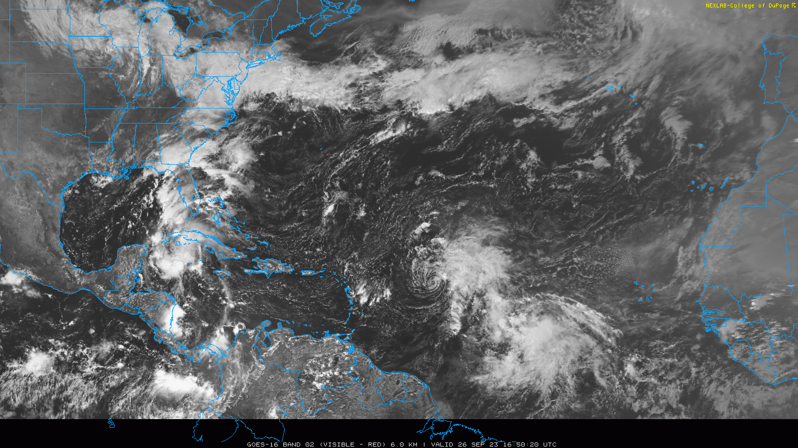
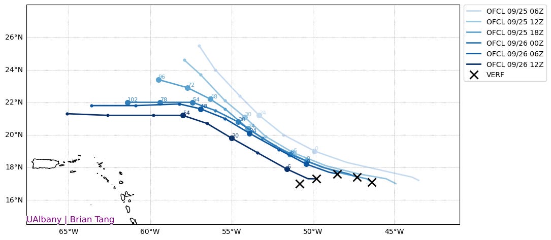
WeatherTiger’s take: The sole named storm as of Wednesday morning is Philippe, a minimal tropical storm around 400 miles east of the Lesser Antilles moving due west at 10 to 15 mph. Philippe is getting raked by strong wind shear, and its low-level circulation has been displaced west of most of its thunderstorm activity.
While Philippe previously was expected to strengthen and turn north, the forecast has shifted as the weaker circulation rides on shallower east-to-west steering currents. Unfavorable upper-level winds should weaken Philippe to a depression north of the Lesser Antilles this weekend. Whatever remains of it may lurk near Puerto Rico for a while, increasing rain chances in that vicinity, and could eventually
WeatherCubette counterpoint: “It looks like a spider. Those are its legs on that side, and those are the others. Looks bad. What’s 3+13? What’s 10+0? [The models] look like a lot of scribbles. Tropical storm.”
Invest 91L
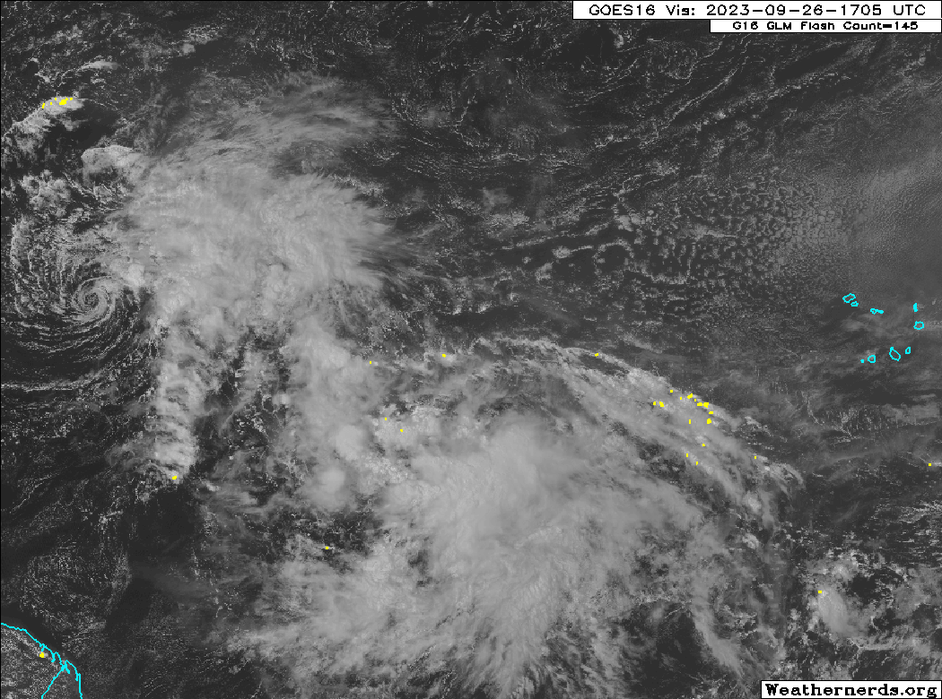
WeatherTiger’s take: A tropical wave, Invest 91L, is currently halfway between West Africa and the Lesser Antilles. This disturbance is a good bet for eventual development and could become Tropical Storm Rina by the weekend. There’s plenty of deep convection and low-level rotation associated with this wave, but its proximity to Philippe may slow organization in the short term. Longer range, conducive upper-level winds and record sea surface temperatures support further strengthening, and 91L may become a hurricane next week.
This system will probably not be a threat to any land areas, though uncertainty in how quickly it organizes and its messy entanglement with Philippe means there is some chance it could move towards the northern Antilles in 5 to 7 days. However, there is no threat to Florida or the rest of the continental U.S, as a west-central Atlantic trough will hustle whatever becomes of 91L north next week.

WeatherCubette counterpoint: “Looks like a U, like the letter U but sideways. Storm in seven days, hurricane. [Points to Venezuela] Green apples have more juice than red apples.”
Gulf of Mexico
WeatherTiger’s take: Earlier in the week, the NHC was highlighting an area of disturbed weather in the southern Gulf of Mexico. Since then, it has been dropped from the NHC tropical weather outlook, but an upper-level level low is still triggering disorganized showers and storms from North Florida to the western Caribbean. Enhanced rain chances will continue here for a few more days before diminishing.

WeatherCubette counterpoint: “That looks like a tree when it puffs out and it looks like a T when it isn’t puffed out. I’m going the opposite way of it. Can I watch Bluey on the iPad?”
WeatherTiger’s Final Thoughts
Despite an unorthodox, kinetic approach to forecasting, the WeatherCubette is on to something: we truly have reached the can-I-watch-Bluey part of the season, in which storm fatigue set in long ago and we’re more interested in something (anything) else than the possibility of more hurricanes. Still, while I concur with my colleague on the lack of immediate threats, one possibility that was a little too esoteric for the Cub to quotably comment on is the need to watch the southwestern Atlantic or eastern Gulf towards the end of next week. With high pressure slated to develop along the East Coast in early October, there may be a sweet spot of favorable conditions south of that ridge in 7 to 12 days. There is no specific threat, but the pattern is one to keep an eye on. Thankfully, no signs of any Caribbean activity brewing as yet.

Overall, despite continued activity, we’ll take a landfall-free end to September and start to October as the one-year anniversary of Hurricane Ian arrives. Let’s hope that the haters are right, and my job really is so easy that a child could do it for the rest of the season. Until then, keep watching the skies.
Storm fatigue….you know you have it when you wake up at 3 am and go to your pad/phone/laptop and read the latest NHC updates followed closely by the dozen or so apps you downloaded telling tales and presenting trails of “data model driven” forecasts. Aaaagh! I’d be better off if there was a forecast slot machine….But than you wait….impatiently…while the doc wakes up, has his micro-brew organic tea and decides to casually acquaint us like Wilderbeasts waiting to cross the river full of big box out of stuff stores, insurance adjuster-no-show, the proverbial Presidential helicopter blowing Aunt Martha’s sacred pictures away, a thousand ant like contractors who arrive at a disaster as if they were a FEMA-we-won’t-be-here-long-be-sure-your-forms-are-complete….and in an instant, we are fully informed, no bs, no Jim Cantore (although I think he should move to the cooking channel)….just the doc, our doc! Clarity matters!
Enjoyed Cubette's forecasting.