Restarting Outlook: The Hurricane Watch Weekly Column for June 13th
Why is the spread between hurricane seasonal outlooks so much larger than usual?
WeatherTiger’s Hurricane Watch is a reader-supported publication. Paid subscribers get Florida-focused tropical briefings each weekday, plus weekly columns, full coverage of every hurricane threat, our exclusive real-time seasonal forecast model, and the ability to comment and ask questions for $49.99 per year.
Whenever hurricane season turns grim and existential, a picture circulates on the sarcastic part of the Internet, also known as the Internet. It consists of an impenetrable scrum of colorful hurricane model tracks, captioned “forecasters show their predictions;” there is also an animated variant consisting of a wad of spaghetti being thrown on a globe, from creators who have pivoted to Fazoli’s sponsored content.
This meme is an understandable response to the agita of hurricane threats, yet the truth is that forecast skill has been steadily increasing for decades. Average NHC forecast track errors are one-third to one-half of what they were in 2000, and reached record lows at several lead times during the 2022 season. However, the wise man knows himself to be a fool. As Ian reminds us, there are still individual forecasts that are highly uncertain, and as meteorologists, it is important to be honest that we do not know what is going to happen in these cases.
We do not know what is going to happen this hurricane season.
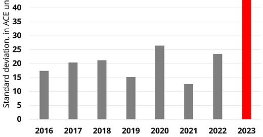
Three weeks ago, WeatherTiger issued our 2023 hurricane season outlook, laying out our reasoning for a potential near-normal season, and why that forecast is uncertain this year. Since then, many other groups have released their numbers. There is always some spread in the predictions due to the disparate techniques used to make the forecasts. However, in 2023, the disagreement amongst the leading forecast groups is massive— by far the largest since 2016, and over twice the average spread.
This year, the forecast scenarios range from total Atlantic tropical activity coming in somewhat below normal to double an the average hurricane season. With this round of seasonal prognostications in the can and no prospects for any tropical development of concern in the Atlantic, Caribbean, or Gulf over the next 7 days, I’m going to take a closer look at why the 2023’s seasonal forecasts are unusually divergent.
The near-normal cluster
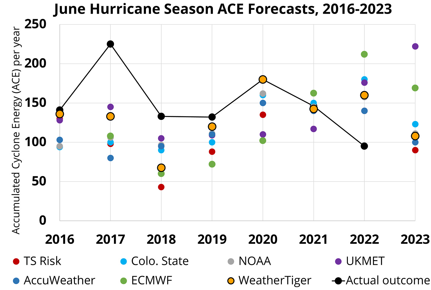
Of the seasonal outlooks from seven leading forecast groups, four predictions are quite close together: Tropical Storm Risk, AccuWeather, NOAA, and WeatherTiger’s own. As shown above, these four outlooks range from 90 to about 110 Accumulated Cyclone Energy units, clustered around the average since 1950 of about 105 units.

Each of these groups uses a slightly different method to grapple with the core paradox of Hurricane Season 2023: the Tropical Atlantic and Equatorial Pacific are both impressively warm. All else equal, the official onset of El Nino conditions last week and the 75% odds of moderate or strong Nino conditions by September would signal a quiet year ahead. All eight years since 1950 with August Equatorial Pacific SST anomalies greater than 1°C have been near, or more commonly, below normal for Atlantic tropical activity. Yet, as shown above, ongoing extreme heat in the eastern Atlantic puts 2023 in a league of its own with little or no historical precedent when jointly considering these two key predictors.

With the negative historical relationship between warm Pacific temperatures and Atlantic hurricane activity and the positive historical relationship between warm Atlantic temperatures and hurricane activity both in play, the statistical, analog, or hybrid models in cluster #1 are splitting the difference and projecting a most likely seasonal outcome close to average. The discussions accompanying these forecasts note that if the Atlantic or Pacific evolve in an unexpected way over the next couple of months, the season could turn out far from our uncertain expectations.
The active cluster
A contrarian take on the 2023 hurricane season is that the Atlantic marine heatwave is so extreme that it will warp the global wind patterns such that the typically detrimental effect of El Nino’s shear on hurricane activity is neutered, allowing an active or even hyperactive season to unfold.
The Atlantic sea surface temperature anomaly map shows why this is plausible. Eastern and Tropical Atlantic SSTs, already sublime three weeks ago, have since warmed to an absurd 1.5 to 4°C above normal and now resemble an angry hornet or fiery shrimp. Computer models simulating the ocean-atmosphere system run by the UK Met Office and European Center (ECMWF) are projecting net Atlantic tropical activity 50% to 100% above normal in 2023. The venerable Colorado State University outlook, which incorporates output from these computer models as well as statistical and analog methodologies, projects 125 ACE units, more than the near-normal cluster but far less than the UK and Euro calls.
Whom to believe?
So, like a bountiful harvest of Dominos, KFC, and the always delicious Taco Bell, there are a lot of possibilities on the table. While past performance is not necessarily indicative of future results, it is instructive to note how predictions have fared in recent seasons.

A few things stand out. First, despite its mighty imprimatur, the Euro has far and away the highest errors for June hurricane season outlooks since 2016, including a huge miss on the high side last year. While the UK’s average errors are lower and comparable to Colorado State and NOAA, it too overshot 2022 well beyond the consensus of other groups. This indicates caution in interpreting dynamical model-based forecasts in 2023, especially the UKMET’s extreme solution. On the other hand, with seasonal influences so far beyond historical ranges, the complex UKMET and Euro methodologies might catch something about the upcoming year that simpler statistical methods would miss. We just don’t know.
Finally, note that WeatherTiger’s June outlooks have averaged slightly lower errors than the rest of the field since 2016. While some of this could be luck, or our model overperforming in more active seasons, our algorithm is also very, very carefully designed to include the maximum number of skilled, physically meaningful predictors while filtering out background noise in the climate system. Suffice to say WeatherTiger is not free wine hour at the Embassy Suites. We do not do sloppy.
Unfortunately, our daily seasonal forecast numbers are drifting higher as June rolls along. Still, the increases are not profound, and I’m doubly hoping the normal camp has the edge this year. There’s nothing worse than predicting something you don’t want won’t happen, like a busy hurricane season, and then it occurring anyway. Overall, there are more things in heaven and earth than dreamt of in climatology, so let the uncertain forecast motivate you to stay nimble this hurricane season. Keep watching the skies.


I'm optimistic for this year. When one does spin up I am looking forward to your track predictions 10 days. As a former boat owner I had to haul my boat each time we were in the NHC forecast cone. Those hauls cast my about $2500 each and not one time was the NHC forecast correct. Of course you cannot count on that if your insurer tells you to pull or not be covered. Looking forward to seeing your track predictions when a storm spins up.