WeatherTiger's Hurricane Helene Florida Impacts Forecast for September 25th
Helene will make landfall on Thursday. These are the wind, surge, and rain impacts Florida and the Southeastern U.S. can expect.
WeatherTiger’s Hurricane Watch is a reader-supported publication. Paid subscribers get daily tropical bulletins, weekly columns, coverage of every hurricane threat, the ability to comment on posts and ask questions, and more. Paid supporters also receive a subscriber-exclusive morning forecast briefing through the threat from Hurricane Helene.
Florida tropical threat synopsis: A major hurricane landfall in North Florida is expected on Thursday, with extreme wind impacts probable in the eastern Panhandle and Big Bend, including Tallahassee, coupled with catastrophic surge in Apalachee Bay south to Tampa Bay. Evacuations/preps should be completed Wednesday night.
Hurricane Helene, an alliterative nightmare for Florida and the Southeastern U.S., remains on a collision course with the Florida Gulf Coast. Track expectations have changed little since Tuesday, and the strongest hurricane landfall to strike Apalachee Bay since the 1840s is expected to hit Thursday evening. Due to the intensity and extraordinary size of the storm, hellish Helene will bring catastrophic, life-threatening surge to the west-central Florida and Big Bend coasts, and a core of destructive winds to a broad swath of North Florida and Georgia that likely includes Tallahassee.
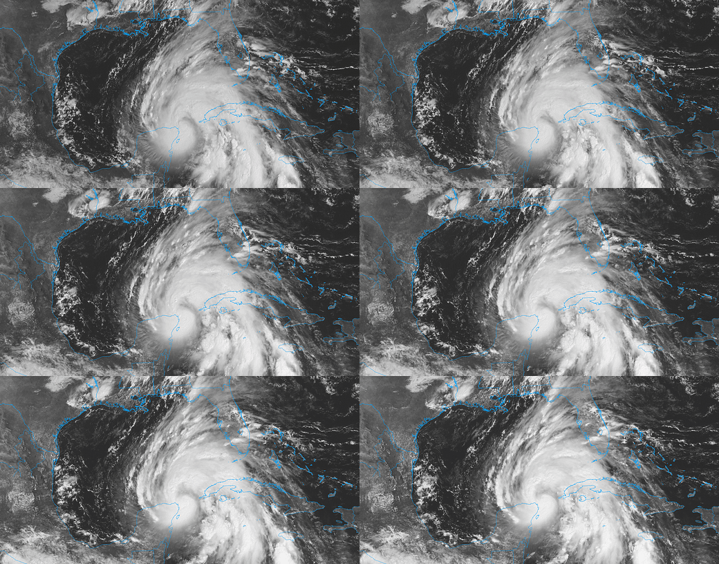
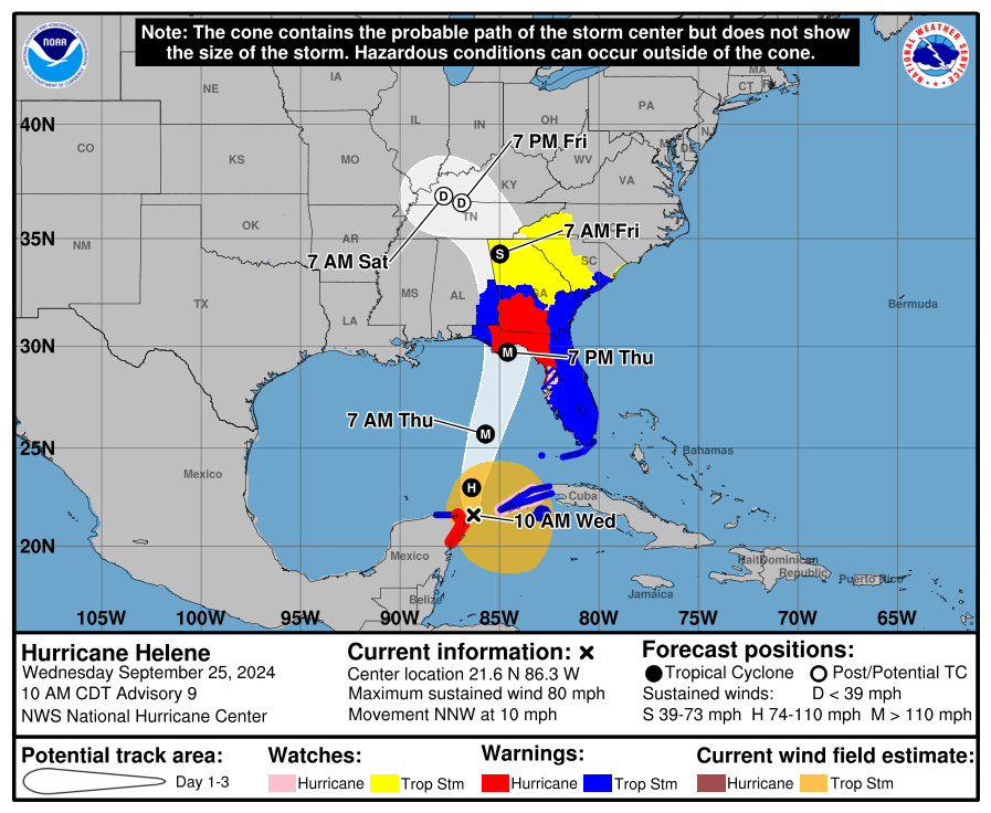
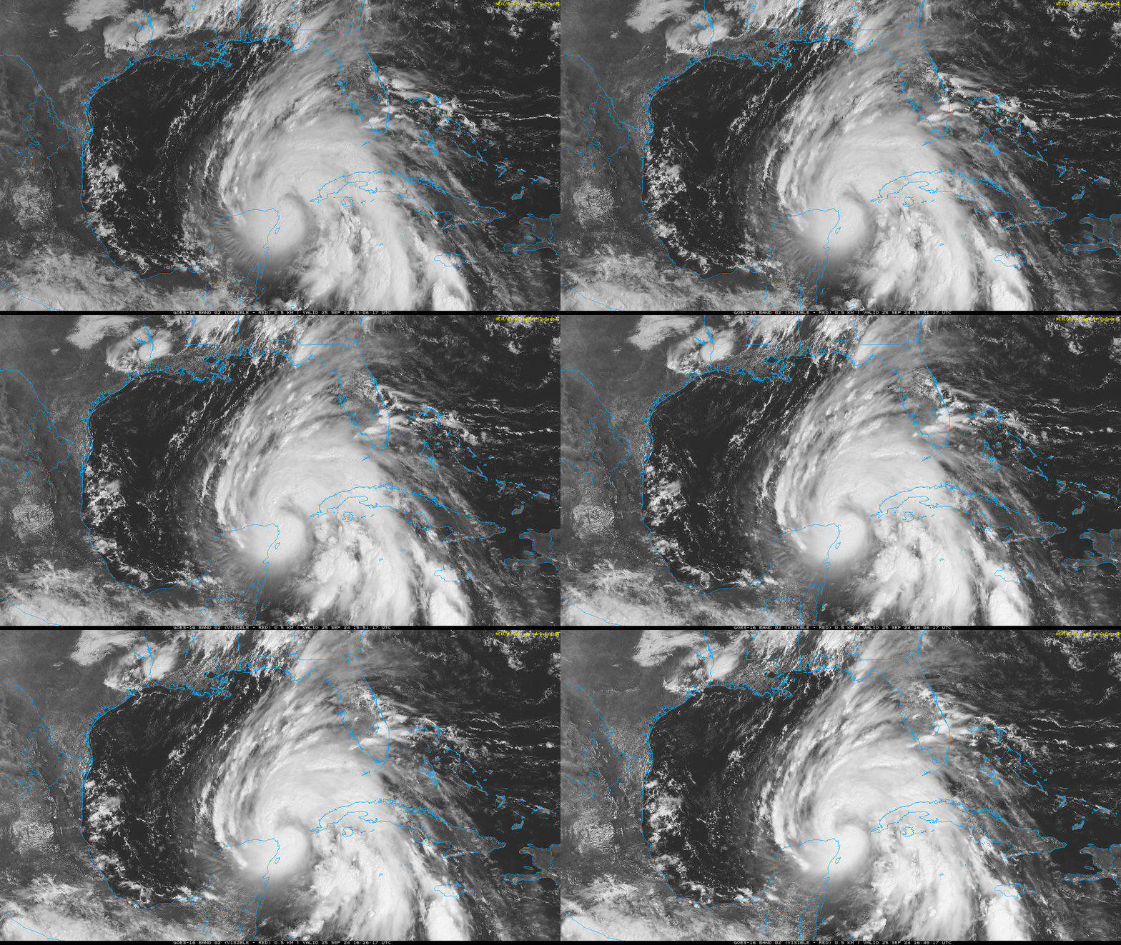
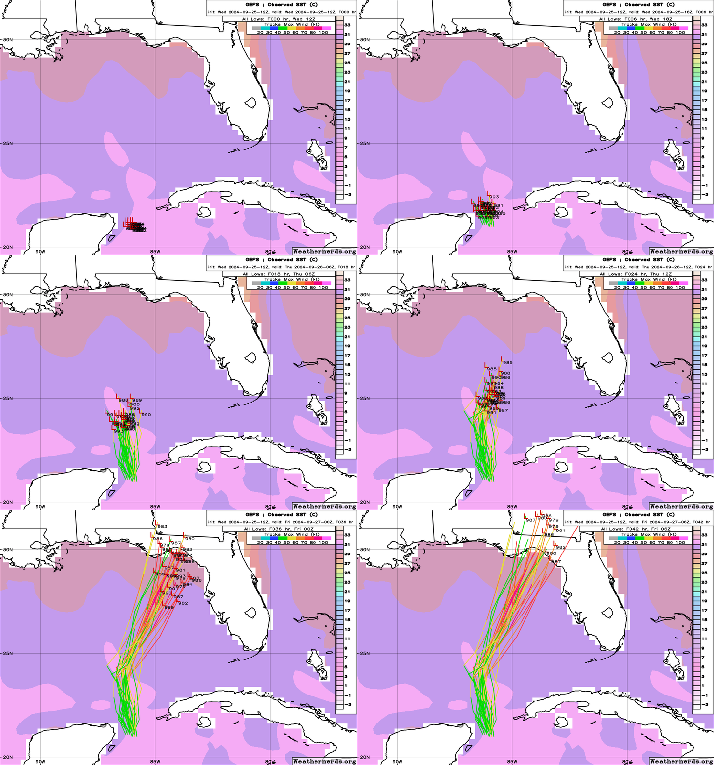
As of mid-day Wednesday, the center of Helene is entering the southern Gulf of Mexico, less than 600 miles south-southwest of Tallahassee and 475 miles southwest of Tampa. Helene’s movement as tracked by Hurricane Hunter aircraft and Cuban and Mexican radar is now just west of due north at about 10 mph. Unfortunately, Helene is shooting the Yucatan Channel gap, so the center of the hurricane will not move over land. That is bad news, as land interaction was a possible speed bump to Helene’s intensification. Rather, the hurricane has followed yesterday’s NHC forecast track and most of the model guidance, and remained over water.
The NHC track forecast has been remarkably consistent since advisory number one on Monday, and still shows a steady march north across the southern Gulf followed by an acceleration north-northeast Thursday, into a narrow channel of brisk steering winds between a upper-level low to Helene’s northwest and a ridge to its northeast. A landfall somewhere in Apalachee Bay on Thursday evening is expected, most likely between 6 p.m. and midnight. This is just a touch west of yesterday’s track.
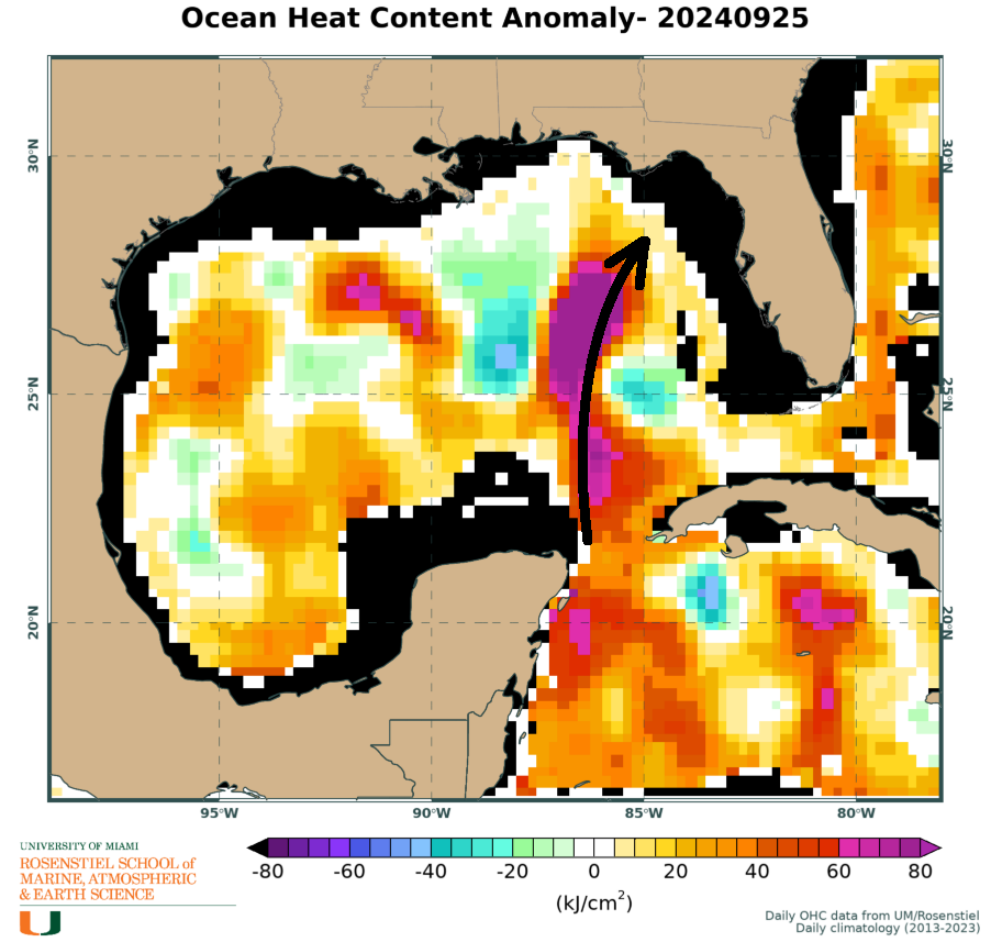
As of 11 a.m. on Tuesday, maximum sustained winds have increased to 80 mph, making Helene a hurricane. Reconnaissance observations and radar suggest Helene is assembling a well-organized inner core this afternoon. Unfortunately, this sets the hurricane up for rapid intensification, a process which may continue into Thursday afternoon. Helene will be crossing a plentiful source of oceanic heat, tracking longways down a finger of the Gulf’s infamous Loop Current, currently heated to a stupifying historical extreme. At the same time, it now appears likely that the spacing between Helene and the Mississippi Valley upper low will be such that it will mostly ventilate, not shear, the inner core of the hurricane during the day on Thursday.
This means yet another hurricane rapidly intensifying in the eastern Gulf on approach to land. It’s not possible to know how high this rapid intensification cycle will loft sustained winds, but a peak between high-end Category 2 and Category 4 intensity is in line with the 11 a.m. NHC forecast of a high-end Category 3, plus or minus typical forecast errors. There is some dependence of track on how fast Helene strengthens, with a bit slower strengthening perhaps tilting landfall odds towards western Apalachee Bay, and faster/more intensification possibly nudging landfall towards eastern Apalachee Bay or the northern Nature Coast.
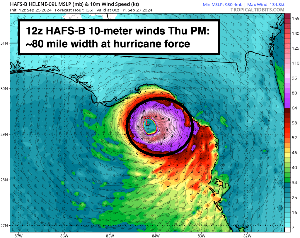
But we shouldn’t be thinking in terms of exact track or categories— really, ever, but especially with Helene. Hurricane categories are defined by the strongest winds at the surface anywhere in the storm, which are usually only are found in a small slice of the eyewall over water. In reality, Helene is a gigantic storm that will produce damaging winds, catastrophic surge, and flooding rainfall over most of Florida and well inland into Georgia and the mid-South, so “category” is going to vastly understate net impact. The “cone” estimates the region where there is a two-thirds probability the center of the hurricane will track. The NHC cone is, say it with me, NOT AN IMPACTS CONE. Severe and life-threatening impacts from Helene will occur hundreds of miles from the cone confines, especially on the eastern half of the storm.
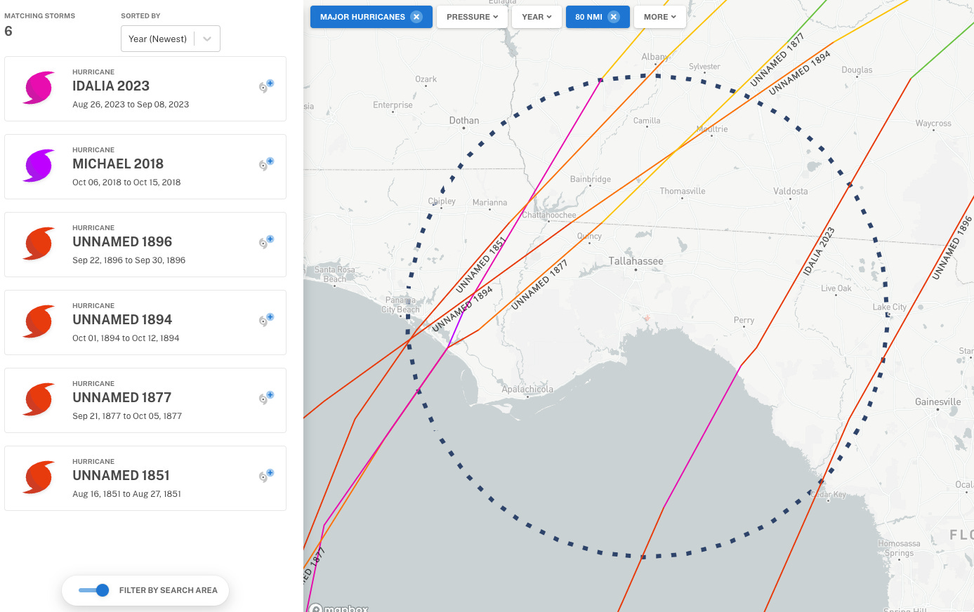
The anticipated landfall on Thursday is a truly unprecedented scenario for North Florida. Between Michael’s Category 5 landfall in Mexico Beach in 2018 and an 1896 Category 3 hit on Cedar Key, the only other major hurricane to make landfall anywhere in Apalachee Bay since 1851 is last year’s Idalia— which as a relatively compact storm, is a poor comparable to the gargantuan Helene. A major hurricane has never on record moved into Leon County, which the current NHC forecast shows.
There is no modern reference point for Helene. Between Tampa Bay and roughly Cape San Blas, this will very likely be the worst hurricane impact in living memory. Let’s go through the wind, surge, and rain hazards one-by-one to grapple with the myriad threats Helene poses to Florida and beyond.
Wind
In terms of winds impacts, there are two stories within Helene. The first is the certainty that tropical-storm-force gusts capable of knocking out power and damaging trees will occur over almost all of Florida starting Wednesday night in the Keys, South Florida early Thursday morning, and North Florida by early Thursday afternoon. A Tropical Storm Warning is in effect for literally the entire state other than the Hurricane Warning zones, excluding Destin and Pensacola), plus southeastern Alabama and south Georgia.
Periodic wind gusts of 40-60 mph, highest in bands, are expected in this Tropical Storm Warning area. Helene’s tropical-storm-force winds are predicted to extend up to 300 miles east of the center on Thursday. These wind radii are larger than more than 90% of comparable storms. Helene’s 20 mph+ forward speed at landfall will also rocket damaging winds far inland, and north Georgia (including Metro Atlanta), plus portions of the Carolinas, are under a Tropical Storm Watch as of Wednesday PM.
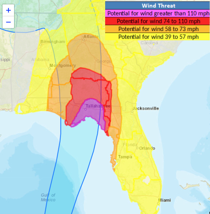
The second wind story is the extent and severity of Helene’s truly destructive winds, which will occur over a more limited but still expansive area closer to the center of circulation. Wind gusts of 75 mph are expected in the Hurricane Warning area, which includes the Central and Eastern Florida Panhandle, Big Bend, and Nature Coast, plus southwest Georgia.
Around a day out from landfall, it’s usually too soon to put a fine point on local wind expectations for the potential core strike zone, as maximum winds can ramp up or down quickly and occur in a limited area that can shift. This time, however, with the noose tightening on Apalachee Bay, there is much higher confidence than usual that destructive winds associated with Helene’s core will occur in the eastern Panhandle and Big Bend. The highest chances of catastrophic wind gusts exceeding 115 mph extend along the coast from roughly Steinhatchee to Apalachicola, then arc inland through Tallahassee towards Thomasville, reflecting the most probable path of Helene’s wide eyewall Thursday night.
This could change. For instance, it’s possible in Tallahassee that Helene edges just far enough south and east of us such that the 100 mph+ gusts that cause structural damage miss us. However, unlike in recent close calls, I wouldn’t bet on such luck holding out again this time. I’ll be tracking the core in real-time early Thursday to make a final forecast.
So: if you’re in Apalachee Bay, the Big Bend, and Tallahassee, your realistic worst case scenario is not thinking about what Michael was like for you. It’s thinking about how is was in Panama City inland to Marianna, and making your evacuation decision accordingly. If you are in the Hurricane Warning region and want to evacuate, head west. Pensacola, Destin, and vicinity is far enough. If you can safely leave, especially if you are in a house with tall trees overhead, you probably should. Weather will be fine to travel through Wednesday night into Thursday morning.
Also, turn off your water if you’re leaving town. Thank me later.
Storm Surge
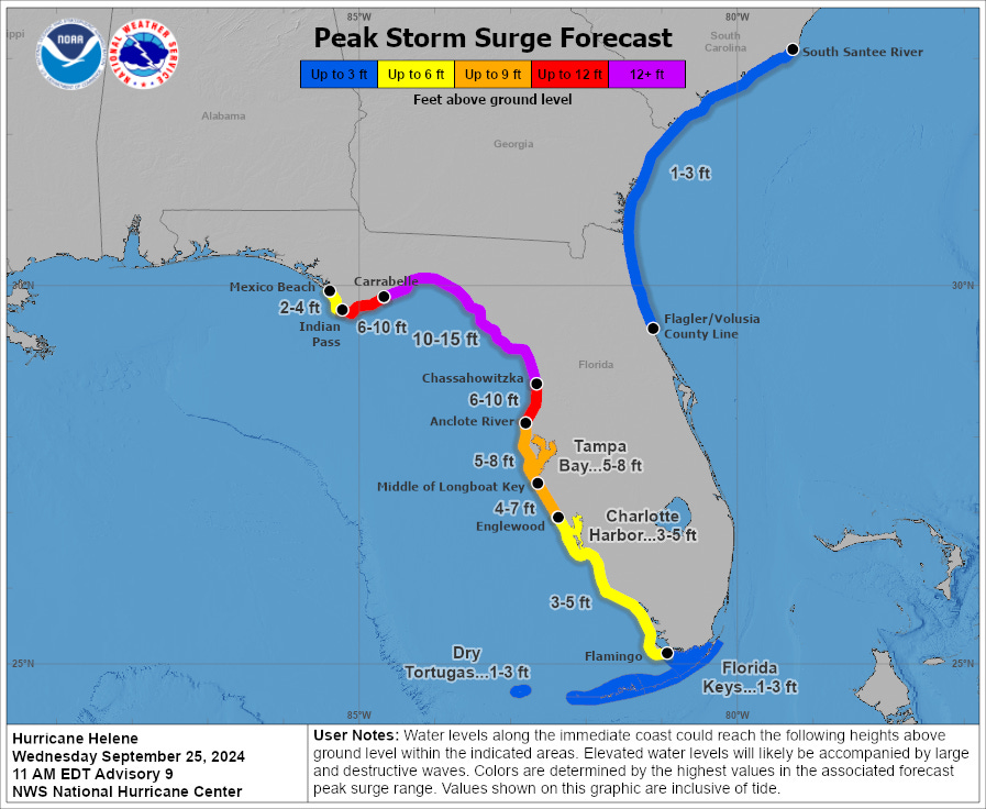
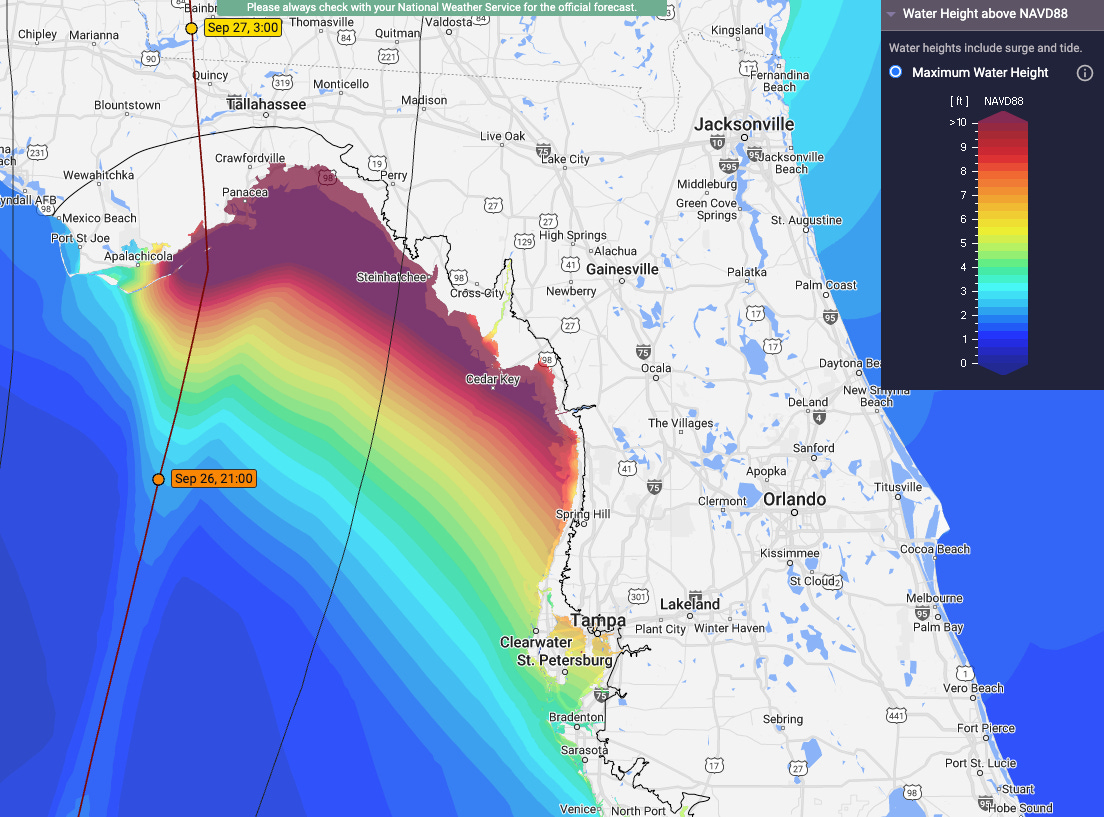
Water is the killer. There is no hurricane hazard more deadly or destructive than storm surge. No matter the precise track, Helene will be a widespread, cataclysmic surge event unlike any modern-era hurricane for Apalachee Bay and west-central Florida. This includes life-threatening surge in Tampa Bay, even with the expected track of the center passing around 100 miles offshore.
Helene’s eastern windfield will be both intense and enormous, pushing a wall of water north onto the shallow continental shelf of the northeastern Gulf that no last-minute adjustments in track or maximum winds will alter. Storm Surge Warnings are in place for the entire Florida Gulf Coast from Cape San Blas to the Everglades, including some areas up to 10 miles inland from the shore itself in the Big Bend, in recognition that the peak NHC modeled storm surge of 10-15’ will overspread huge areas of low-lying “dry land” adjacent to Apalachee Bay and the northern Nature Coast. The high tide on Thursday night at around 11 p.m. in Apalachee Bay is also ill-timed, coinciding with the strongest onshore flow during and post-landfall, further increasing the expected inundation.
As usual, areas west of the landfall point (past Cape San Blas) will see much lower, limited surge with offshore winds barring a dramatic change in the forecast. However, if you are east of the landfall point, a major surge event is essentially locked in by the size of Helene. This includes in Tampa Bay, where the NHC is predicting 5-8’ of storm surge. This would be the worst surge event since the 1921 Tarpon Spring hurricane in the Tampa area, and 3-5’ of surge is also expected in Southwest Florida. Remember, if you are evacuating to escape a surge threat, you don’t need to drive to Mississippi to avoid a life-endangering situation. You just need to go a few miles inland, to somewhere 30’ above sea level rather than 6’. Additionally, those surge numbers in Tampa Bay could go even higher and push above 8’ if Helene tracks more like 50 rather than 100 miles west, which would also increase surge in Southwest Florida.
Bottom line, if you get an evacuation order, you Just. Need. To. Leave. Go several miles inland to higher ground. Helene’s surge impacts are without living precedent and highly likely to happen. Just go inland!!
Rainfall
When people think of hurricane threats, excessive rainfall and flooding isn’t necessarily the first thing that comes to mind. But it should be—nearly one-third of tropical cyclone-related casualties are caused by freshwater flooding.
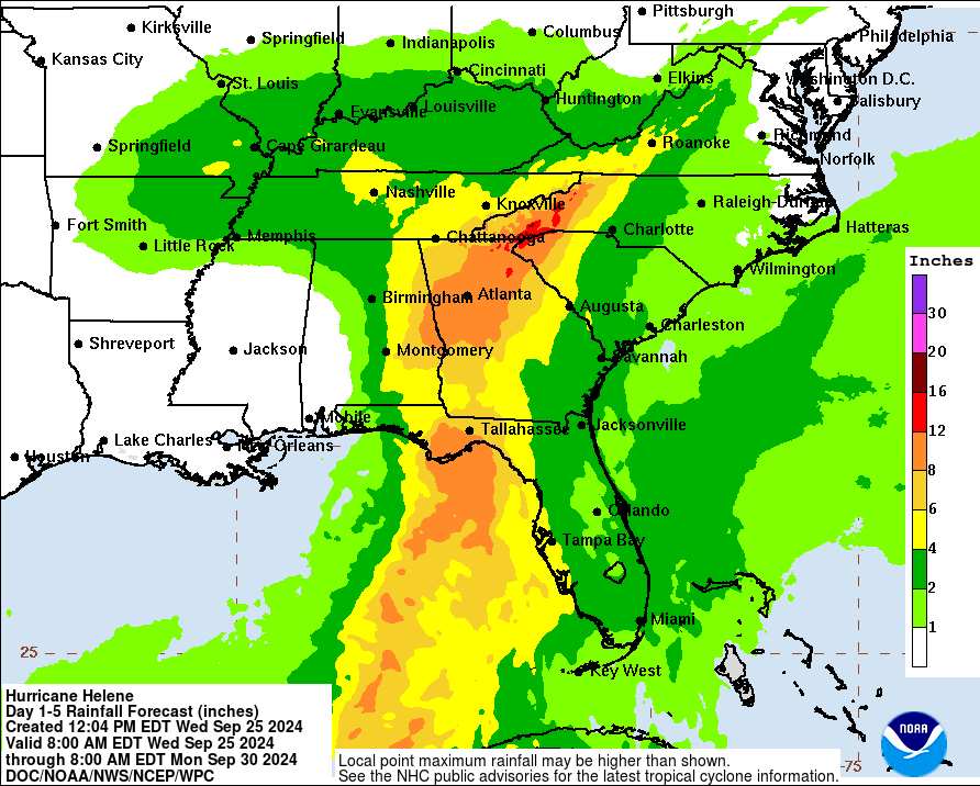
Helene will be accelerating by landfall to a forward speed of 20 mph or more, which all else equal increases the inland wind threat and lowers the flash flood threat. However, Helene is so large that widespread 4-8” rainfall totals across North Florida, much of Georgia, and north into the Appalachians equals flash and freshwater flood potential from Thursday into the weekend. A Flood Watch is in effect from South Florida to the Destin area and north to western Virginia for this reason. Local totals of 8”+ are possible in the eastern Panhandle as well as in the mountains of north Georgia and western North Carolina, where there is a high risk of flash flooding.
As far as timing, periodic rain bands will overspread the southern half of Florida overnight, and the remainder of the state Thursday morning. Look for rains to be heaviest and most persistent between early Thursday and early Friday in the eastern Panhandle, Big Bend, and west-central Florida, clearing Friday morning. Today’s rainfall will be scattered and intermittent, so finalize your evacuations and preparations prior to daybreak Thursday.
Honestly, folks, I’m running out of adjectives to describe the severity of the total situation with Helene, like something from a lingering bad dream. Unfortunately, this ain’t a dream no more, it’s the real thing. React. Prepare. Evacuate. Take care of yourself. Take care of your neighbor. Everyone across Florida and the Southeast U.S. should be closely monitoring the latest information from the National Hurricane Center, your National Weather Service office, and local emergency management. The expected worst-hit areas in Florida have through tonight to make preparations, so use that time. I’ll be back tomorrow with a region-by-region threat breakdown ahead of landfall, and tonight for a live forecast video at 9:30 p.m. via Facebook Live.
Good luck, Florida. Yet again, we’ll need it. Keep watching the skies.
Updated 10:00pm: Forecast video with latest information on Helene:



In your next update, please discuss why Helene is so large. (What determines the size of a hurricane?)
Question - do folks who live in Tallahassee need to turn off their water if they're leaving their home? Thanks!