


The Long Weekend Rule: WeatherTiger's Hurricane Watch for May 30th
South Florida is likely to see rainfall next weekend from a possible tropical storm.

Welcome back to WeatherTiger’s Hurricane Watch! A free preview of our daily briefing will continue into June. If you like what you read, please support us by signing up for our comprehensive coverage of the 2022 hurricane season. Premium subscribers get Florida-focused daily tropical briefings like this one each weekday, plus weekly columns, full coverage of every U.S. hurricane threat, and our real-time seasonal forecast, all for $7.99 per month.
Florida tropical threat synopsis: The southern half of the Florida peninsula may see impacts between Friday and Sunday from a tropical storm. Excessive rainfall is by far the greatest concern, though coastal waters may also see tropical-storm-force winds.
Active Storms: None.
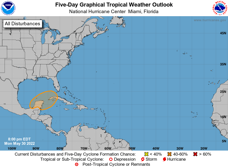
Current disturbances in NHC outlook, with 2-/5-day NHC development odds:
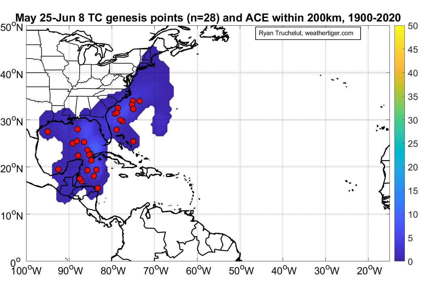
Southern Gulf/NW Caribbean (0/50%): It’s just not a three-day weekend without a tropical threat for Florida. The short version of the state of affairs is that the remnants of Hurricane Agatha in the eastern Pacific will merge with a broad area of rotation over Central America over the next few days, with the development of a large, messy tropical depression possible in the far southern Gulf or northwestern Caribbean on Thursday or Friday. As seen above, this is not an unusual timing or location for early season development.

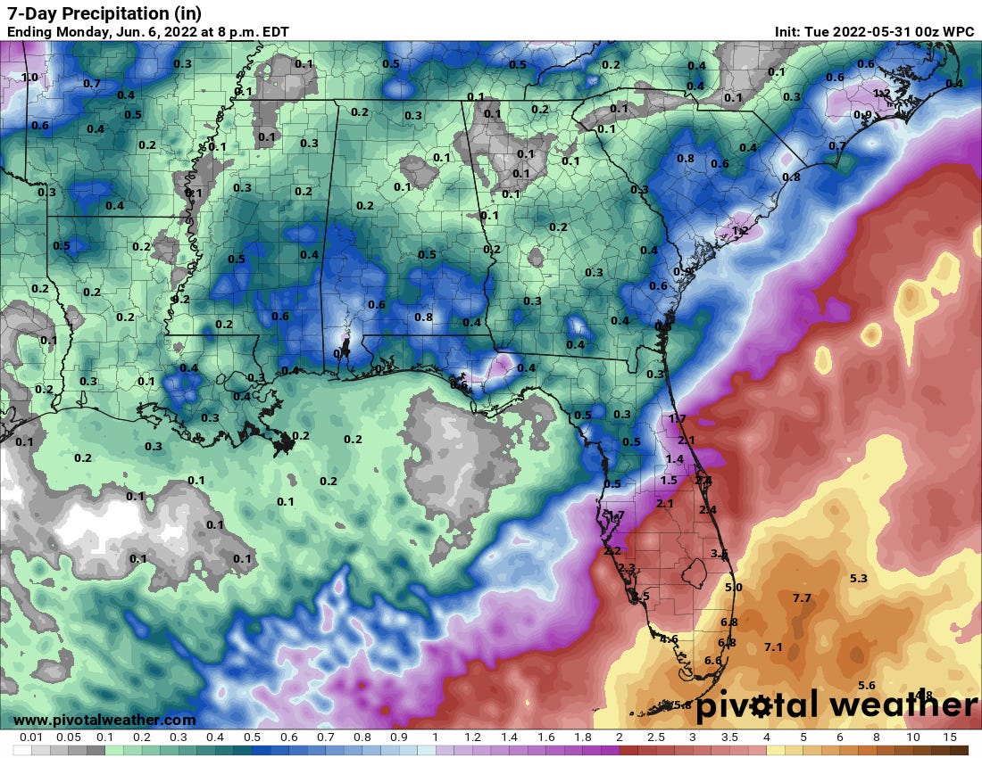
Chance of a TC passing within 300km from 5/30 12z Euro Ensembles. With troughing over the eastern U.S., anything that develops (or doesn’t develop) is likely to hustle northeast over the far southwest Gulf on Saturday, and be located east of the Florida peninsula by late Sunday. While I would give better than 50/50 odds of this system becoming the first named storm of 2022, its large size and loose structure likely mean maximum sustained winds will top out at 50 mph or below prior to reaching the southern half of the Florida peninsula or the Straits of Florida. While this certainly means gusty coastal winds are possible along the immediate SW/SE Florida coast, the primary impact of this system with or without development will be heavy rainfall. Totals of 3-6” are possible in the southern half of the peninsula, with the dividing line between wet weather south and more intermittent showers north to be determined by exactly when and where a distinct low center forms. Thus, there is a good deal of uncertainty in the forecast for Central Florida at this time.

Possible rain totals for Florida over the next 7 days. Overall, this is a typically wet early season tropical threat to Florida, and not something of deep concern. We’ll keep you posted on the particulars as the situation becomes clearer later this week.

Elsewhere: Nothing of note, though additional spin-ups in the Caribbean are plausible in this kind of pattern into mid-June.
Next report: On the road tomorrow, so look for the first column of the year detailing the latest on this threat by noon on Wednesday.
Glad to be a subscriber and to read your clear analysis of Agatha or potential Alex and their destinations and traveling gear.