Ship of Fuels: Hurricane Watch Weekly Column for June 26th
The Tropical Atlantic has several waves with a solid chance of development over the next week. Why is the Cape Verde season starting so much earlier than usual?
WeatherTiger’s Hurricane Watch is a reader-supported publication. Paid subscribers get comprehensive daily tropical briefings, weekly columns, full coverage of every hurricane threat, our exclusive real-time seasonal forecast model, and the ability to comment and ask questions for $49.99 per year. If you enjoy reading this newsletter, please consider supporting!
If you’re like me and your favorite four minutes of 2024 was when the moon blotted out the sun, June has been a tough month for you. While Central and South Florida have seen normal thunderstorm activity in the past few weeks, North Florida and the rest of the Gulf Coast have been broiling under what feels like the angry sun from Super Mario Bros 3. Temperatures haven’t broken records, but the cloudless heat has been consistently aggravating.
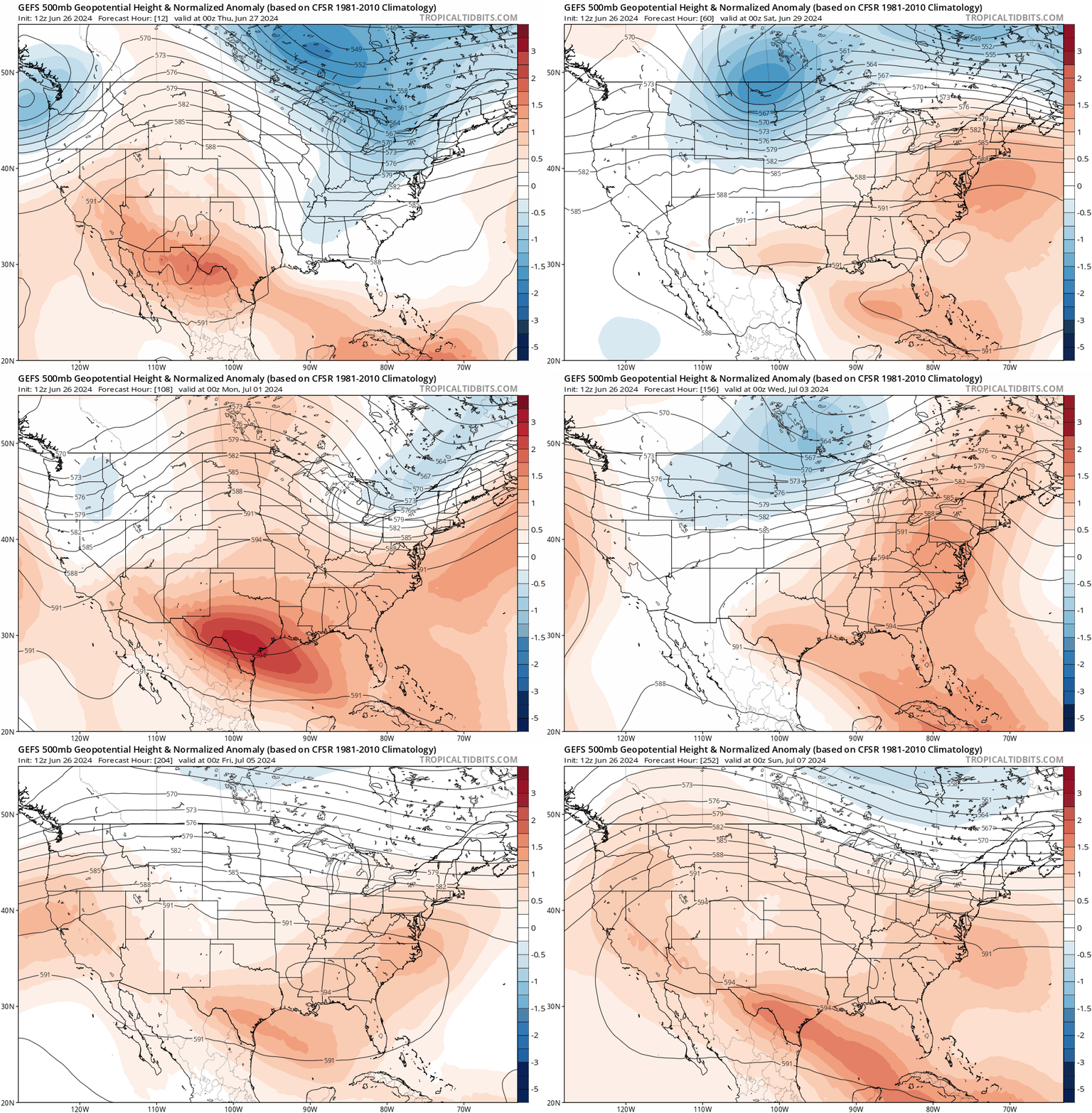
While daily rain chances in Florida creep higher over the next few days, temperatures will remain indefinitely above normal across the Southeast due to a ridge of high pressure aloft. This persistent ridge will keep conditions sweaty and irritating well into July, but its one upside is that it protects the continental U.S. from possible tropical threats that may arise in the Atlantic and Caribbean.
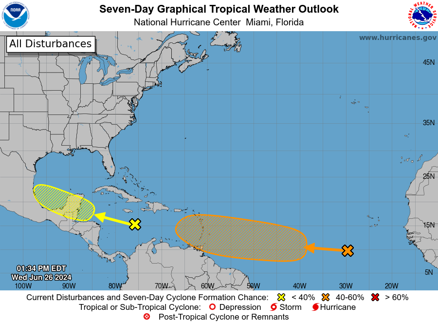
As I’ll discuss further next week, mid-summer marks the timeframe in which tropical waves emerging from the West African coast start to have some chance at development. Today, there are three waves with potential to become tropical storms over the next 10 days. The first is a tropical wave racing across the west-central Caribbean that will crash through Central America by Friday. It might briefly organize this weekend if it can gain enough latitude to reach the far southwestern Gulf, but I wouldn’t bet on that due to the smooshing influence of the southern U.S. ridge. The only Gulf impacts, if any, will be more rain for the Mexican coast.
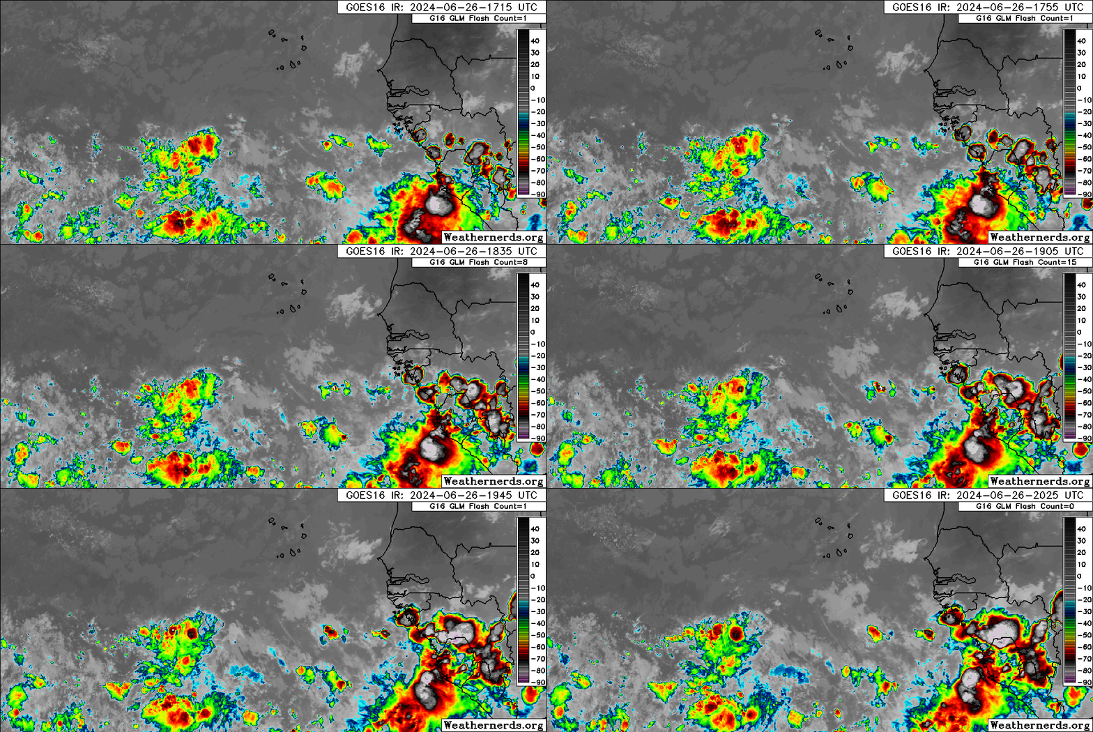
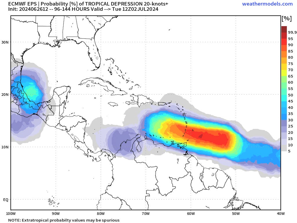
Waves two and three are in the eastern Atlantic and about to depart Africa. Historically, tropical storm formation is rare east of 60°W in June, though this may be changing. The more western of the two waves has some decent associated rotation, and seems far enough south to mostly avoid the dust, shear, and stable airmass to its north. If that continues to be true, this system has a good chance of organizing into a depression by the weekend as it continues west towards the southern Lesser Antilles. Interests in the Windward Islands should be monitoring this system as a flood threat with modest potential wind impacts.
Models are probably too aggressive in intensifying this wave, with the hurricane-strength solutions floating around as unrealistic as John Morgan’s physique on a Morgan & Morgan billboard. Still, a quick-moving, vigorous tropical storm cutting west between Trinidad and Barbados is a possibility come Monday. As the system continues west-northwest next week, the already brisk low-level trade winds accelerate further, and it is likely to either struggle, or revert to a wave in the central Caribbean, as suggested by the limited collection of similar historical events. Stout Gulf Coast ridging through the first week of July means there is a low chance of anything that would develop turning north towards the continental U.S., with Central America the most likely destination.
The easternmost tropical wave currently near Africa will also move west for the next week, trailing a few days behind the leading wave. If it can consolidate south of 10°N, this wave too has a chance of taking advantage of an unusually low-shear environment in the Tropical Atlantic. Consecutive tropical waves developed into Tropical Storms Bret and Cindy last June, so twinning wouldn’t be unprecedented. Either way, there’s a long time to watch that wave, and upper-level winds will likely revert to more typical hostility for early July in its wake.
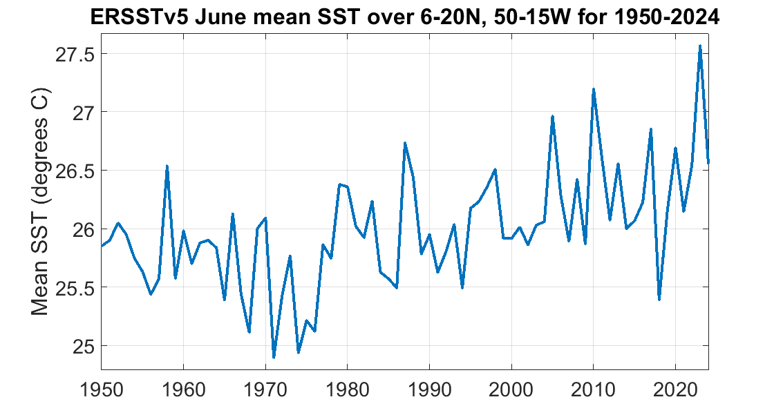
June activity in the Atlantic’s Main Development Region and may not feel unusual in the wake of Elsa (2021), Bonnie (2022), Bret, and Cindy (2023). However, there are only six total instances of June tropical storm formation east of the Lesser Antilles. That’s because both the ocean and atmosphere in the Tropical Atlantic are usually hurricane-hostile in early summer; the atmosphere is often sheared and choked with African dust, and the ocean is usually too tepid to support storms. While shear and dry air remain perennial impediments, ocean temperatures are much warmer in the eastern Atlantic than they used to be, so if the other pieces fall into place, tropical development becomes a possibility. While the world’s oceans have all warmed in the past few decades, this trend is pronounced in the eastern Tropical Atlantic. These waters average 1.5-2°F warmer now than 50 years ago, with four of the warmest nine Junes occurring since 2020. The specific reason for this has to do with the vagaries of maritime law, so get ready to throw the book at the pirate.

In 2020, a treaty changed the composition of marine shipping fuel to reduce its sulfur content, causing ship emissions to contain far fewer sulfate aerosols. While sulfate emissions have lots of nasty effects like acid rain, they also increase the local proportion of incoming sunlight reflected straight back into space without warming the ocean. Four years ago, those reflective sulfate clouds abruptly decreased, and water temperatures in busy shipping lanes like the northern and eastern Atlantic have since warmed disproportionately as more solar radiation is absorbed by the ocean.
Basically, without the Weezer Cruise featuring Weezer (America’s #1 Weezer cover band) pumping out sweet sulfate aerosols alongside crunchy riffs, an earlier start to tropical activity in the Main Development Region may become an enduring feature of hurricane season. While this fringe benefit of pollution may be gone, the fringe benefit of a hot, humid, and gross ridging pattern for the Gulf Coast may protect us from this week’s precocious crop of waves. Keep watching the skies.


Wow, the 2020 treaty. Actual evidence of man-made climate change.
"with the hurricane-strength solutions floating around as unrealistic as John Morgan’s physique on a Morgan & Morgan billboard."
Except that anatomically, if wearing pants, his pockets will be so bulging with thousands of $100 bills he will will look like a Joe Paloka punching bag that in my very younger days was impossible to knock over.