Outlook Cloudy: Invest 97L Update for August 1st
Odds of a tropical system in the eastern Gulf near Florida by the end of this weekend are increasing, but the ultimate outcome remains unclear.
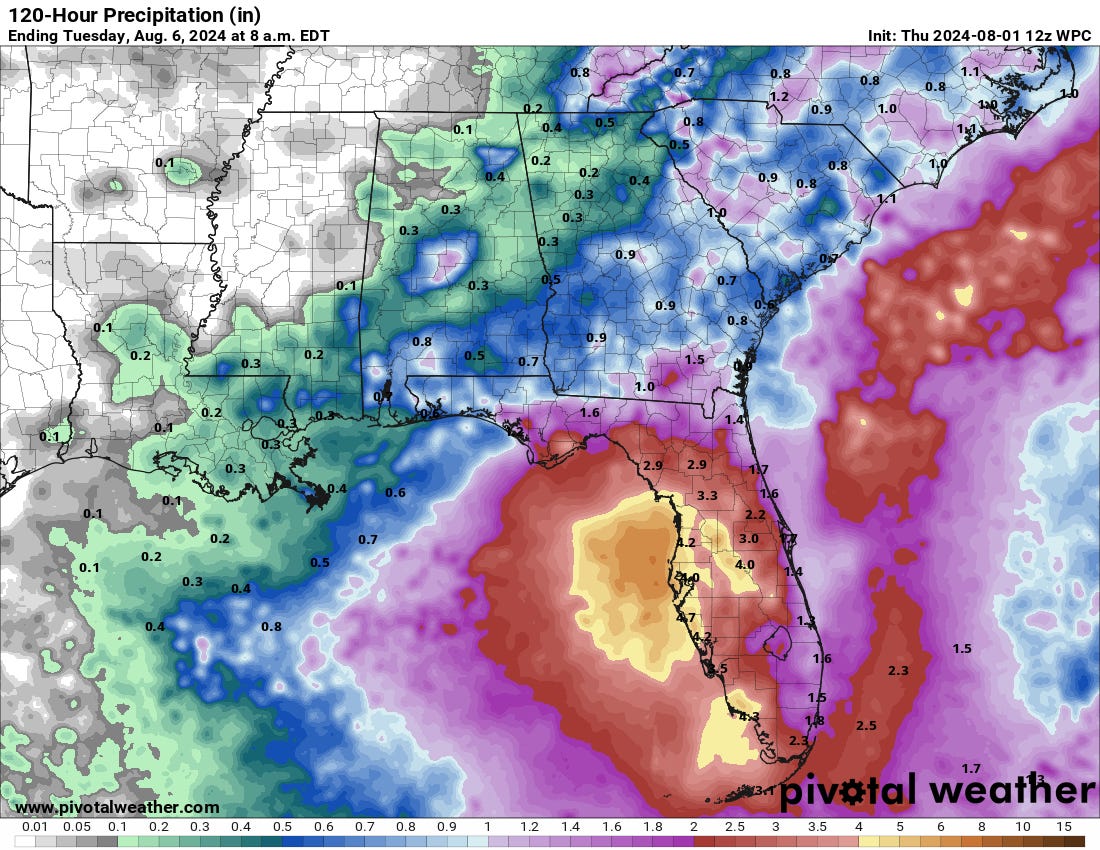
Florida and continental U.S. tropical threat synopsis: A tropical wave crossing Hispaniola is likely to become a depression or storm by Monday near or just west of the Florida peninsula. Look for rain impacts in Florida starting this weekend, with other potential impacts still up in the air as the longer-term forecast is very uncertain.
Almanac: It’s Thursday, August 1st… day 62 of the 2024 hurricane season, 121 days to go. By total storm energy, the season is 6.9%, 17.6%, and 12% complete for the Atlantic, continental U.S., and Florida, respectively.
Active storms: None.
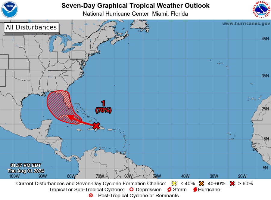
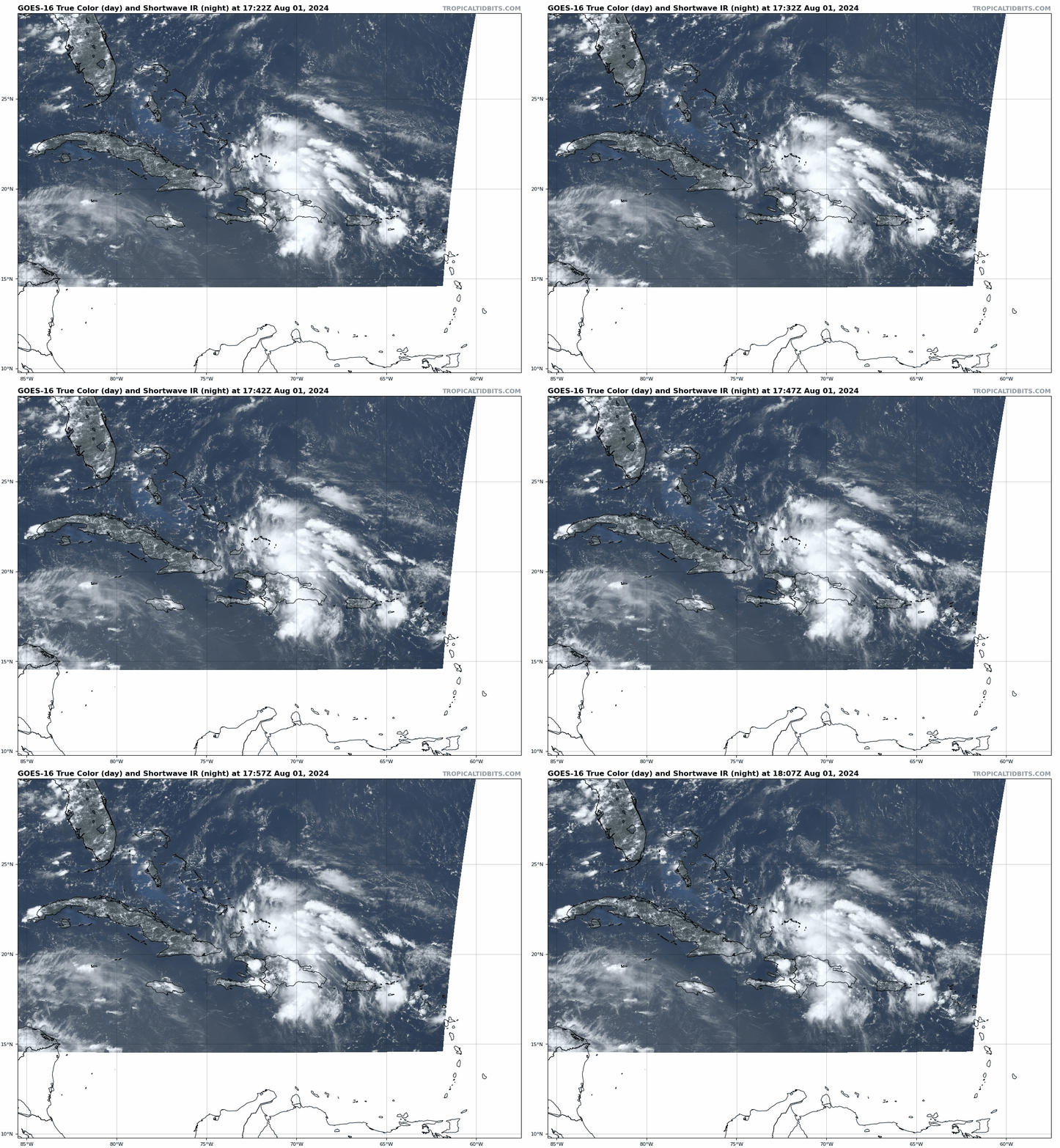
Disturbances in the NHC tropical weather outlook: The tropical wave of keen interest, now designated Invest 97L, is crossing Hispaniola this afternoon. NHC chances of development over the next seven days have increased to 70%, including a 30% chance through Saturday. This wave is now generating extensive convection over the Turks and Caicos, Dominican Republic, and Haiti, another big step up in coverage from yesterday.
In yesterday’s update, I discussed that where the incipient circulation started to develop along the long wave axis would make a big difference in whether the system eventually passed east, over, or west of Florida. This question is somewhat answered today, with the low-level rotation taking shape directly over Hispaniola. That means: 1) 97L is not going to develop north of the Greater Antilles, taking a track east of Florida mostly off the table and 2) significant land interaction will continue over the next 24-36 hours. With Hispaniola’s and Cuba’s mountains scrambling the low-level structure of 97L in the short-term, development is unlikely until Saturday, when the disturbance will be near the Straits of Florida.
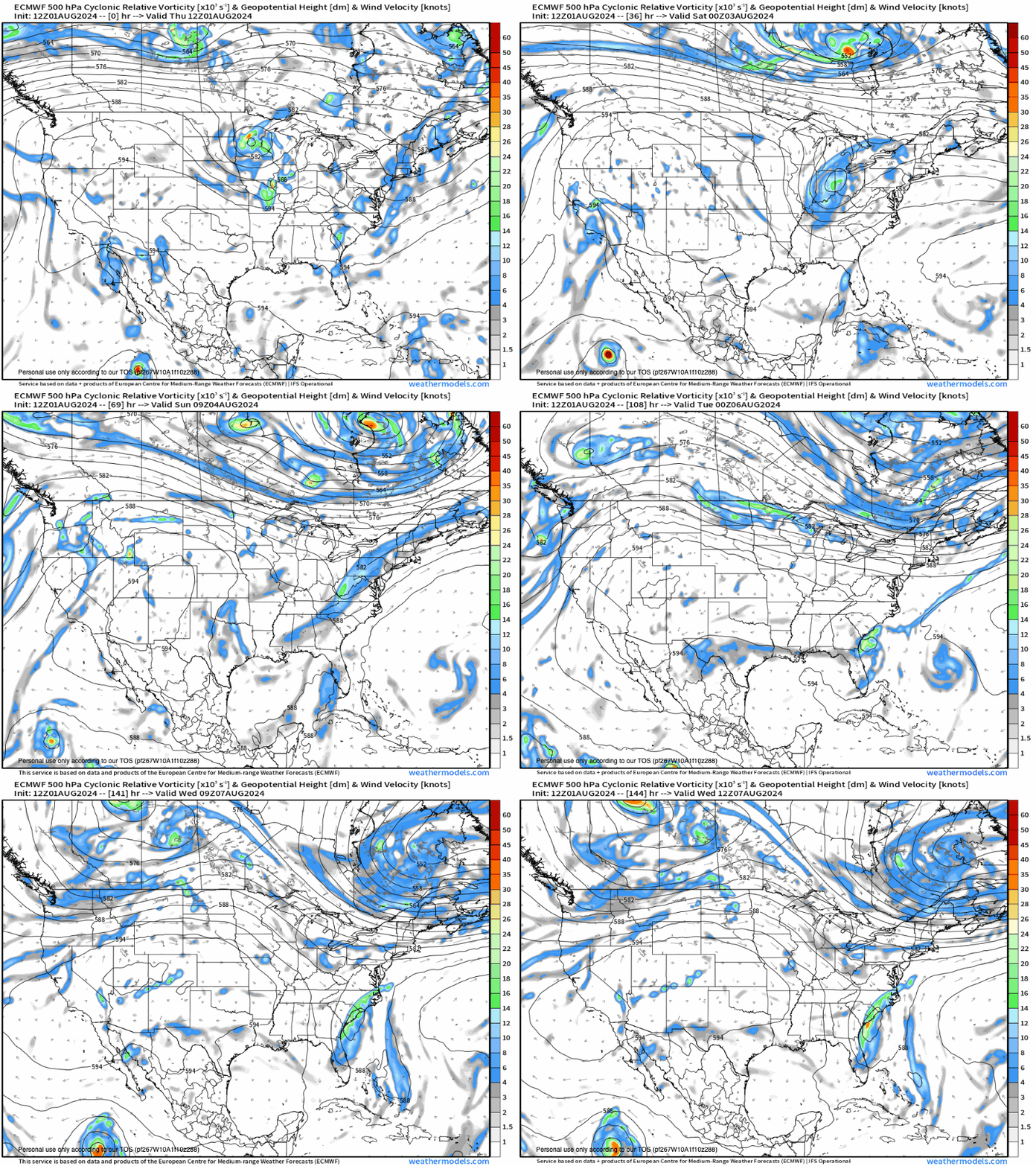
At that point, the disturbance will start to turn north as it feels the tug of an upper-level trough digging south over the U.S. East Coast. Once 97L is clear of land, the fact that it is generating plenty of convection already and that the outflow environment will be quite favorable mean that a tropical depression will likely develop in the eastern Gulf by Sunday. Alternatively, there is a chance the turn north takes the low directly over the Florida peninsula on Sunday, in which case there may not be enough time for a depression or storm to develop. Look for plenty of rain in the Florida peninsula between Saturday and Monday either way.
The other major piece of the puzzle has to do with the steering winds in the eastern Gulf (or inland) early next week (or lack thereof). While global models have been trending deeper with the eastern U.S. trough over the weekend, it is still expected to weaken and be replaced by a broad, flat south-central U.S. ridge by the middle of next week. That replacement will result in a region of minimal steering winds across the Gulf, Southeast U.S., and western Atlantic starting in about 5 days.
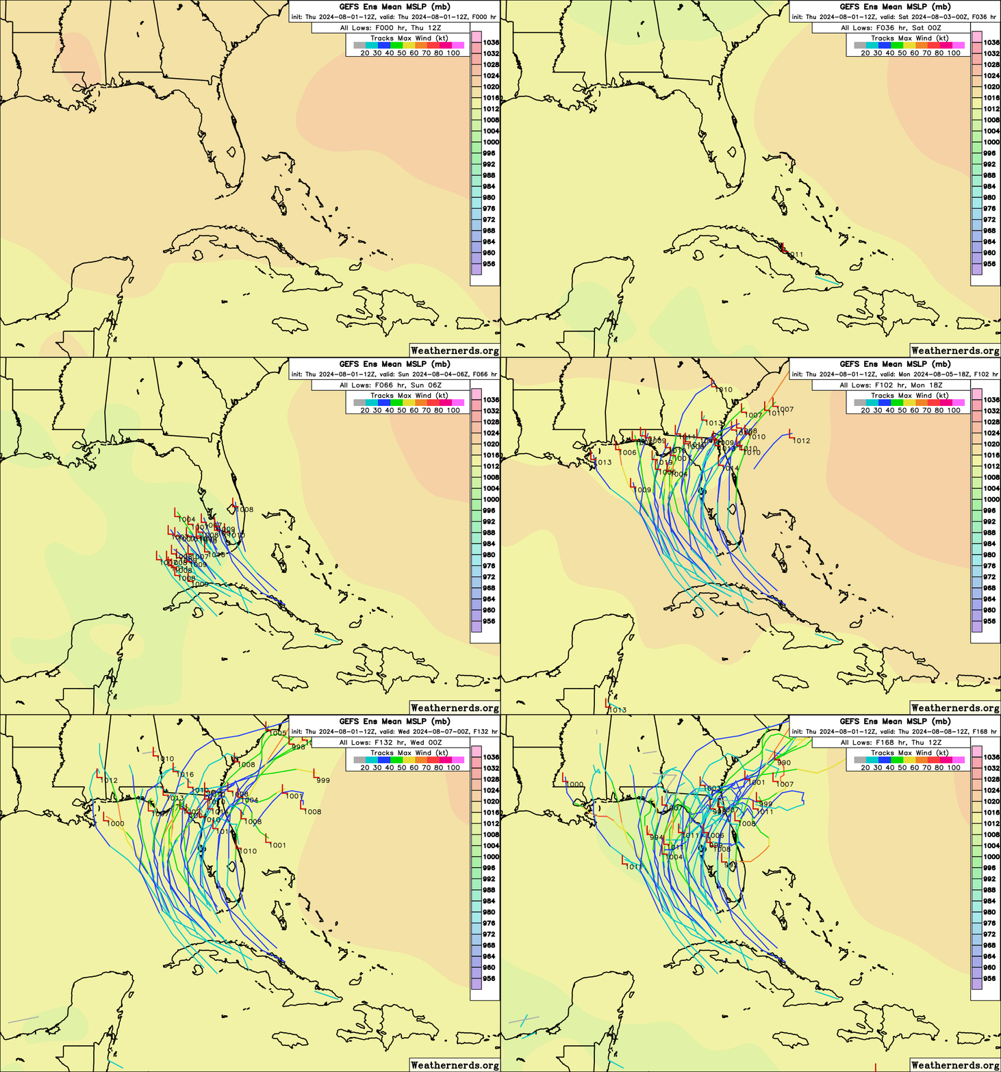
The question is whether 97L will be in the Gulf, inland, or back offshore south of the Carolinas in the Atlantic when steering winds go slack. If the system gets stuck under the ridge, it’ll likely be with us for a while in some form. A cleaner getaway in which the original trough captures 97L and hustles it to the northeast is also a possibility. Unfortunately, there’s still no good answer to this question today, with 97L remaining broad and another day of unpredictable land interaction still ahead.
Since yesterday, the potential for a track east of Florida has been mostly eliminated. Additionally, the stronger trend with the trough and increased chance of development of a depression on Saturday or Sunday argue for a curving track near or just west of the Florida peninsula Gulf Coast through Monday, with plenty of tropical rain in tow. The truly dangerous case, in 97L tracks farther into the eastern Gulf, misses the trough, and has the rest of the week to strengthen is a possibility, though perhaps not the favored one at this point given the trends highlighted and the more progressive 12z models.
Overall, the prognosis for 97L remains tricky and uncertain, just as it was yesterday. The out-to-see eastward track is out now, but I wouldn’t be surprised to see more jumps in the model guidance in the next day or so before more of a forecast consensus comes into focus. Stay tuned.
Elsewhere: No other disturbances to discuss.
Next update: Next bulletin tomorrow around noon.


Crossing fingers it stays east from Mississippi.