One Weird Trick to Make Hurricanes Disappear: Hurricane Watch Weekly Column for August 31st
An unprecedentedly quiet August closes with two disturbances poised to develop soon, but no U.S. threats for Labor Day weekend.
If you are not already a supporter, please consider signing up for a paid subscription to WeatherTiger’s Hurricane Watch. You’ll get Florida-focused tropical briefings each weekday, plus weekly columns, coverage of every U.S. hurricane threat, our exclusive real-time seasonal forecast model, and the ability to comment and ask questions, for $7.99/mo. or $49.99/yr.
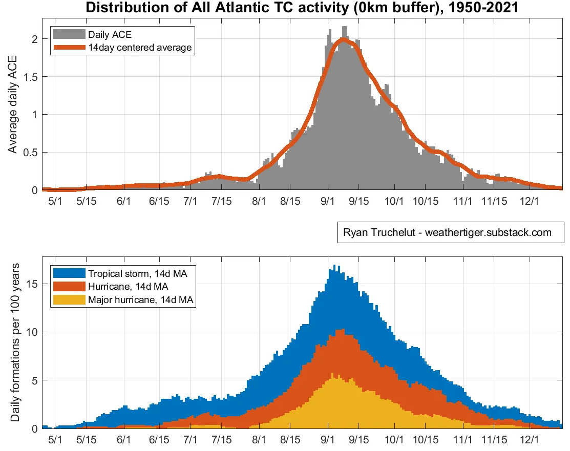
The hurricane climatology adage “June, too soon; July, stand by; August, come they must; September, remember; October, all over” is a hoary chestnut that inaccurately elides serious risks at the beginning and end of the season. However, it’s hard to argue with this rhyme of ancient mariners concerning an absolutist stance on the peak of hurricane season.
August, come they must. No asterisks, no footnotes, no equivocation.
Except 2022: no hurricanes. More like August, massive forecast bust.
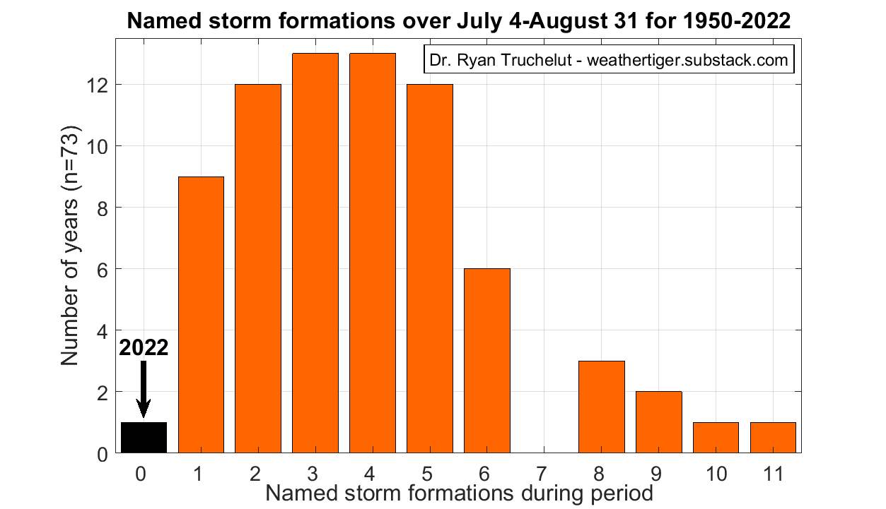
Since Colin weakened to a depression on July 2nd, there have been zero named storms in the Atlantic, Caribbean, and Gulf of Mexico. This is a feat without precedent since reliable records began around 1950, with a more typical number of storms in that interval three to six.
Unless a rabbit is pulled out of a hat later today, 2022 will be the first August since 1997 (a raging El Niño year) to be storm-free. Remarkably, it will have done so despite warmer than average waters in the Tropical Atlantic and a potent La Niña, both of which usually tilt the odds towards more frequent storm development.
That 2022 has seemingly discovered one weird trick to make hurricanes disappear is, of course, great news. Let’s hope that positive momentum towards cancelling undesired seasons also extends to flu season, love bug season, the season in which tree gametes cause uncontrollable sneezing fits, and all seasons of Dexter other than 1, 2, and 4.
While the Atlantic is slowly but surely becoming more active today, there continue to no threats to Florida or the continental U.S. on the map. This is especially welcome as a full 25% of Florida’s historical landfall activity is crammed into the first two weeks of September; assuming nothing shocking happens, we will have escaped the first half of hurricane season scot-free.
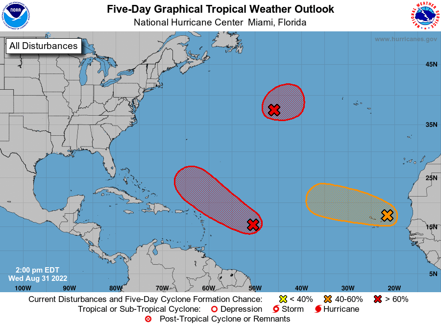
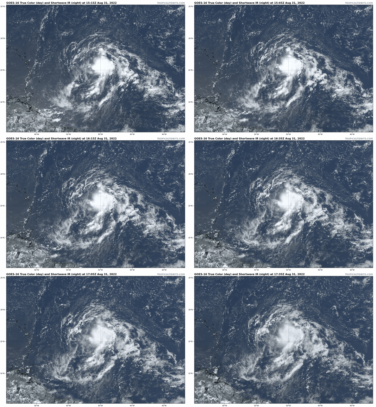
However, early September is not likely to continue the stormless streak, with four areas of disturbed weather in the mix. The first is an area of low pressure around 500 miles east of the northern Lesser Antilles, Invest 91L. This low has become more organized in the last 48 hours, with increased deep convection located to the east of a better-defined low-level circulation center. While this disturbance is still contending with an arid airmass to its west, slow development into a depression or tropical storm is likely into the weekend as it moves west-northwest and passes north of the islands.
This system may intensify further next week as it is turned north by an upper-level trough well east of the Bahamas. Bermuda should keep an eye on this storm, but as of now it is no threat to the U.S. coast.
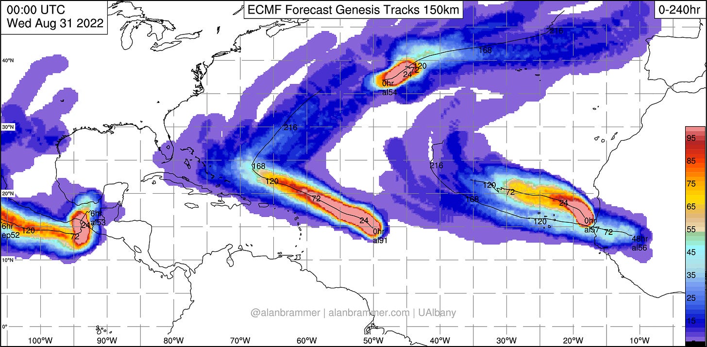
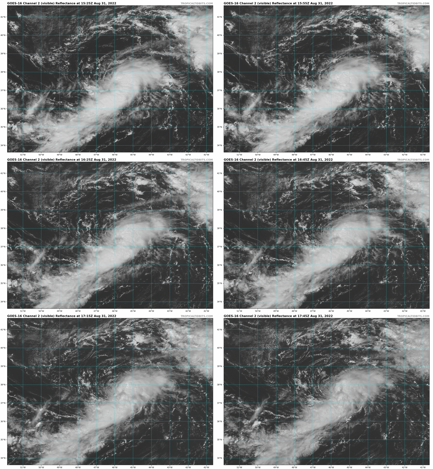
A second candidate to check a name off the list this week is Invest 93L, a non-tropical low in the north central Atlantic, about halfway between New Jersey and the Azores. The mid-latitude Atlantic is much warmer than normal this year, so this low is likely to take on subtropical or tropical characteristics as it meanders and strengthens through early next week. This low will accelerate east towards western Europe late next week, where it could result in a significant storm. You know it’s a quiet hurricane season when there are more threats to France than Florida. J’accuse, Saharan Air Layer!
Finally, two Cape Verde tropical waves each have a brief window for limited development this week before propagating northwest into the who-cares zone of the tepid subtropical eastern Atlantic. Neither is a threat to any landmass.
Adding it up, WeatherTiger’s live seasonal forecast model has shed another 20-25 ACE units since last week thanks to continued calm, and is now projecting a 55% chance of a near-normal hurricane season and a 25% chance of a below normal year.
To channel either Chubby Checker or Ludacris depending on your age, how low can seasonal ACE go? Well, assuming a couple of named storms develop over the next five to seven days, that projection may start to stabilize, or at least decline less quickly heading into the historical apogee of hurricane season in the second week of September.
The hurricane climatology curve is “strongly peaked,” as there is only a narrow window in which favorable ocean, mid-level humidity, and shear conditions for development in the Tropical Atlantic overlap. Early in hurricane season, shear is typically lower, while sea surface temperatures and moisture lag; late in the season, those two ingredients are present, but upper-level shearing winds flense easterly waves. All three conditions are usually conducive in September alone, which is why half of Atlantic hurricane activity occurs during the month, with the peak of the season around the 10th.
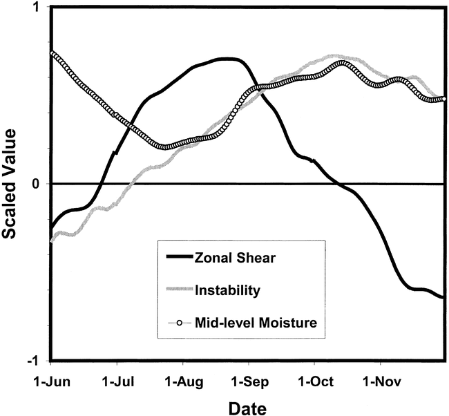
Recently, ocean temperatures have been plenty warm and shear generally lower than average, but dry air has put the kibosh on development time and again. You can’t bake a cake with two-thirds of the ingredients, and lacking moisture, this August has been an inert pile of flour and baking powder.
Still, with just one missing ingredient that is capable changing rapidly, there remains the possibility of a busier second half of the season, particularly with a Pacific typhoon likely to throw a diabatic heat bomb into the Northern Hemisphere jet stream pattern next week with unknown consequences. So, enjoy the rarest of all meteorological phenomena, the quiet Labor Day weekend in the Tropics, for the gift that it is and keep watching the skies.


