


Lee Cyclogenesis: Hurricane Watch Weekly Column for September 5th
Major Hurricane Lee is likely this week; Florida is safe, but the rest of the U.S. East Coast should keep an eye on it.
WeatherTiger’s Hurricane Watch is a reader-supported publication. Paid subscribers get Florida-focused daily tropical briefings, plus weekly columns, full coverage of every hurricane threat, our exclusive real-time seasonal forecast model, and the ability to comment and ask questions for $49.99 per year.
There are more things in heaven and earth than are dreamt of in climatology. In non-Shakespearean terms, this means that weather events that haven’t been observed in our short span of reliable records can and will happen.

For instance, in August, Tallahassee and many other Florida cities smashed the record for warmest month by nearly a full degree; we also closed out a cruel summer with the first-ever major hurricane landfall between the Panama City and Cedar Key areas, and the first hurricane-force inland wind event in the Big Bend in at least 75 years. Usually anything traveling faster than 74 miles per hour in that part of Florida is immediately pulled over and issued a $295 ticket. Not this time.
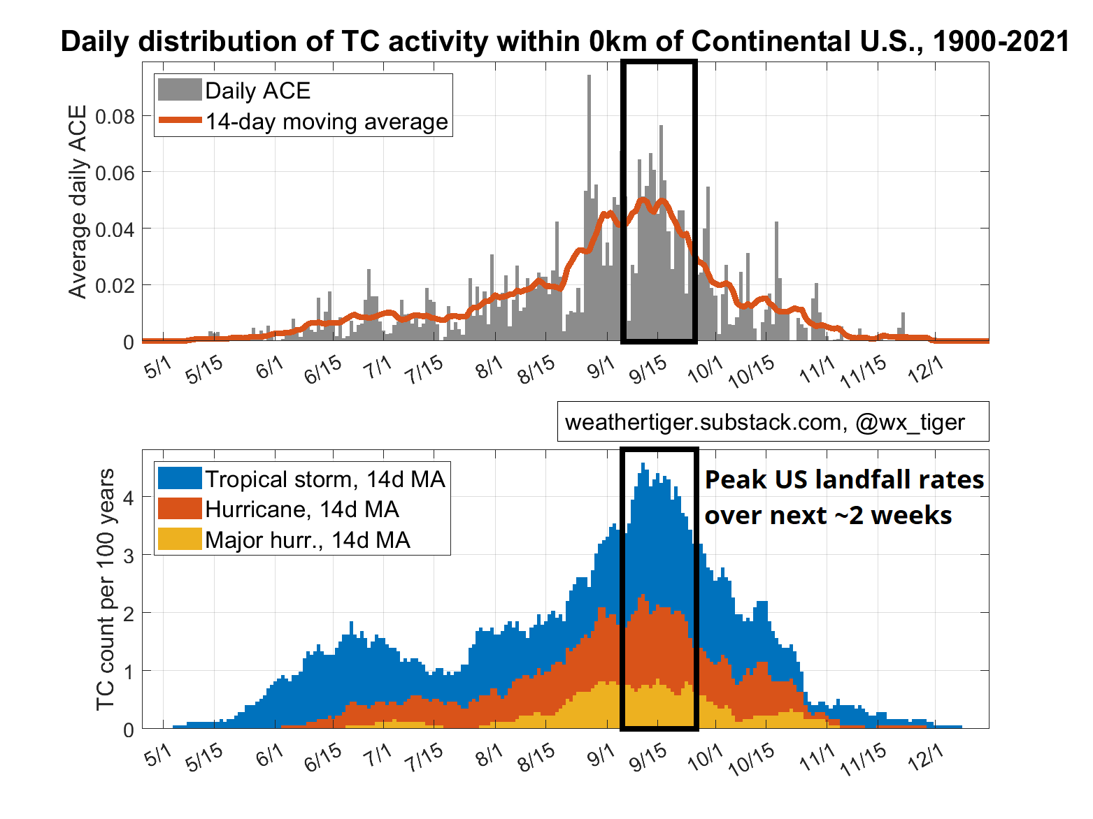
As Florida’s Gulf Coast again digs out from a regionally devastating and broadly exhausting storm, the Tropics continue to roil entering the most active two weeks of the season, in which around one-quarter of the Atlantic’s hurricane activity has historically occurred.
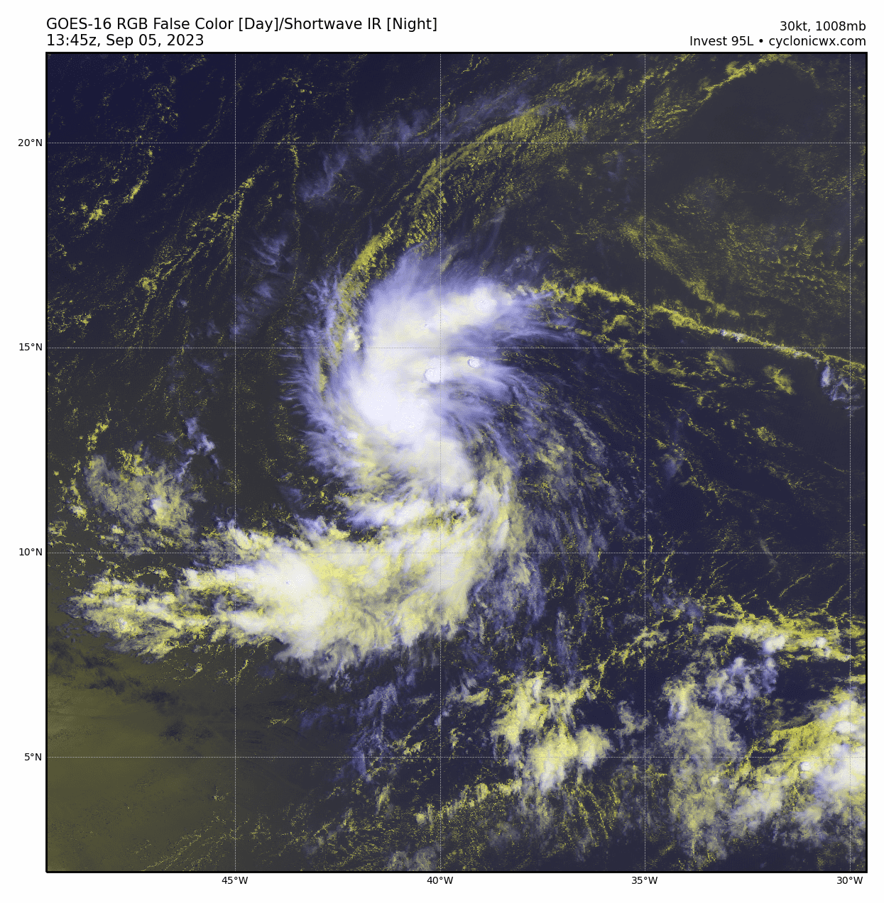
Today, at least, that activity is concentrated in areas where hurricanes are common in September, and does not immediately threaten the continental United States. As of mid-day Tuesday, the National Hurricane Center has started issuing advisories on Tropical Depression 13, which will become Tropical Storm Lee by early Wednesday.

Future Lee is currently located about halfway between West Africa and the Lesser Antilles, in the heart of the Tropical Atlantic’s Main Development Region, moving west-northwest at about 15 miles per hour. This general forward motion will continue into the weekend, and Lee should gain enough latitude to pass safely north of the U.S. Virgin Islands and Puerto Rico in around 5 days.
However, the northern Antilles should monitor Lee carefully, as the intensity expectations for this hurricane are wild. Lee will be moving across untouched Tropical Atlantic waters that are two to four degrees warmer than average, with ideal mid-level moisture and upper-level wind conditions for rapid intensification. The official forecast has Lee as a Category 4 Hurricane by Saturday morning, which is handily the most intensification ever predicted by an initial NHC advisory.
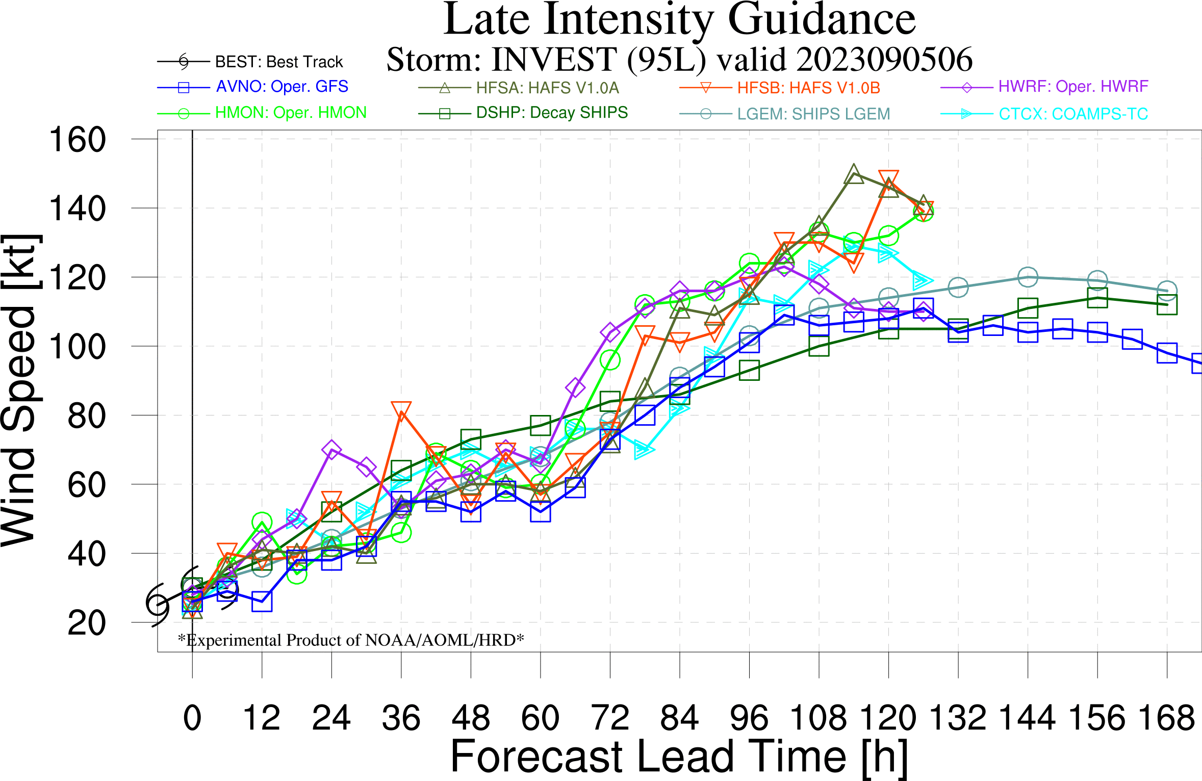
Even this forecast may be a bit conservative, with the hurricane-specific models that performed well with Idalia’s intensity forecast calling for near-Category 5 strength by late in the weekend. The specifics are to be determined, but it is likely that a powerful hurricane will be located south of Bermuda and east of the Bahamas early next week.
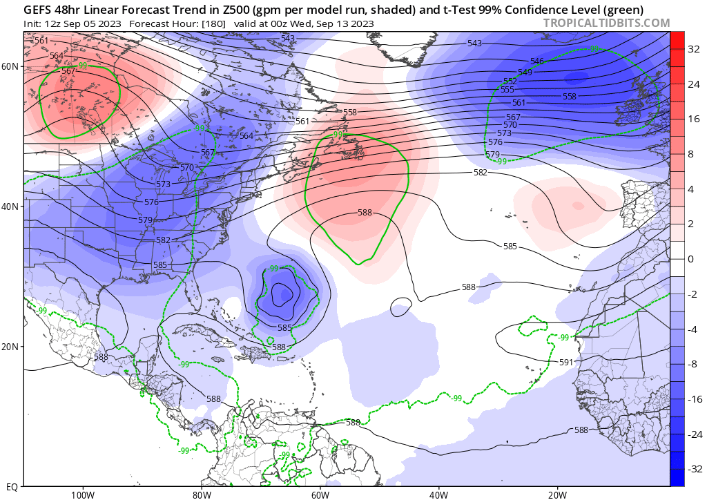
While the specter of an Irma-like Cape Verde beast is alarming, the good news is that all models show a deep trough of low pressure over the eastern United States six to ten days from now. All else equal, this protective dip in the jet stream should turn Lee more to the north around this time next week.
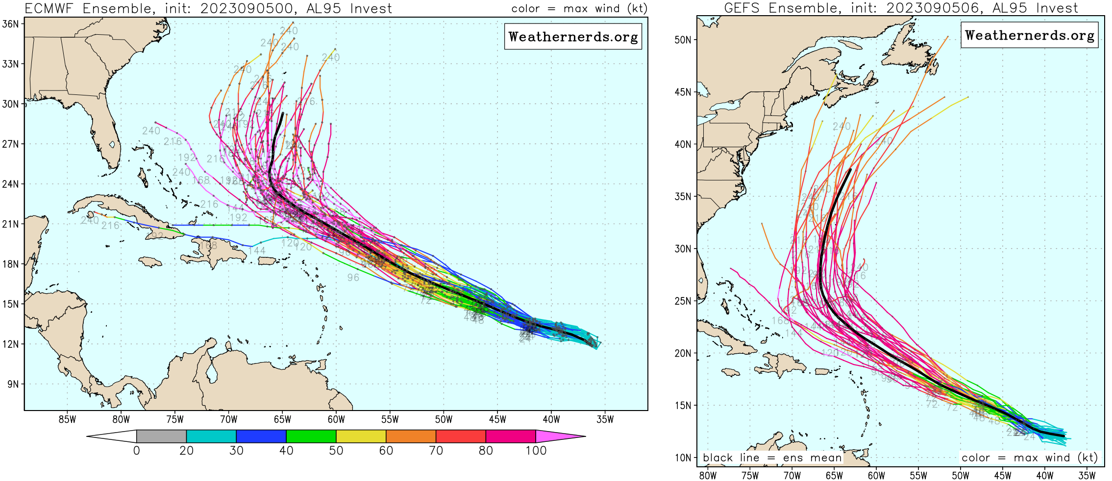
Unless something very weird happens, that northward movement should occur well east of Florida, and Lee does not look like a threat to the state. On the other hand, the indeterminate details of the squeeze play between that eastern U.S. trough and a resilient ridge of west-central Atlantic high pressure does not completely rule out an eventual threat to the mid-Atlantic or New England.
The most likely outcome is that Lee remains offshore, but with Lee ten or more days out, there is sufficient uncertainty in the forecast such that the Eastern Seaboard should keep close tabs on Lee, especially as it will be a strong hurricane. Tropical cyclone (TC) threats to the northern half of the U.S. East Coast are uncommon, but happen predominantly in September when they occur. I’m not saying there will be a TC north of DC, but it can’t yet be eliminated as a possibility. Stay tuned.
Elsewhere, befitting the peak of hurricane season, look for one or two more storms to develop through mid-September to the east of Lee. None of these will be any threat to land. Overall, there are no tropical threats to Florida over the next 10 days, and hopefully that will continue into the second half of September so devastated Big Bend communities can start the long process of recovery.
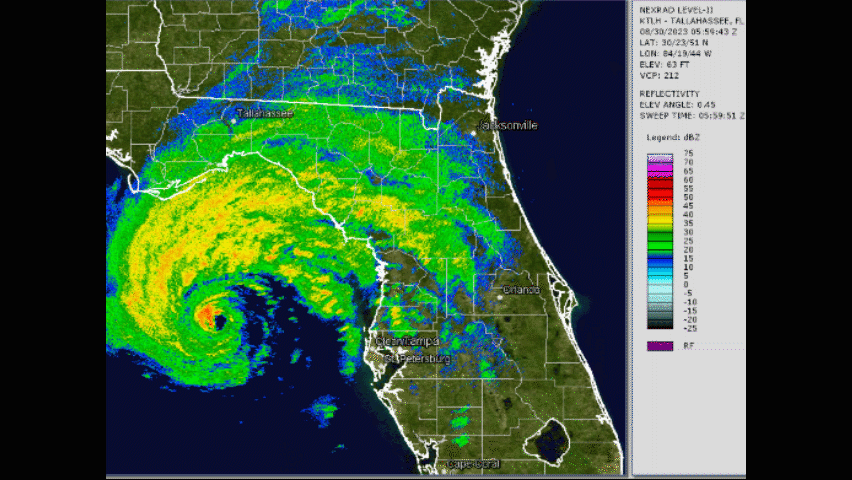
These towns—Steinhatchee, Cedar Key, Perry, Mayo, Madison, Live Oak, and many others—deserve long-term support and gratitude, as they have absorbed a devastating trolley problem punch in lieu of more densely populated parts of Florida. A track just 30 miles farther west would have brought the western eyewall of Idalia into Tallahassee, pushing the manageable 45-60 mph gusts observed into the destructive 80-100 mph range.
Conversely, a track 50 miles east might have doubled the already formidable 4-5’ of surge seen in Tampa Bay. Idalia hit an area with few observing stations, and National Weather Service damage surveys are ongoing, so the full portrait of exactly what happened in Idalia is yet to completely emerge.

However, from what we already know, it’s clear that history isn’t the guide it seems to be. In an age of illogic in which major hurricanes prowl the shallow waters of Apalachee Bay and Rice-a-Roni is now the Atlantic Coast treat, nothing can be taken for granted in the Tropics. The next few weeks of hurricane season look tame for Florida, but the fridge at WeatherTiger’s World Headquarters remains fully stocked with two of every flavor of LaCroix just in case, as we lick our wounds and keep watching the skies.