Heads Up, TD 7 Up: Hurricane Watch Weekly Column for September 14th
Tropical Depression Seven will bring rain to the Islands over the weekend, and bears watching for U.S. interests down the road.
If you are not already a supporter, please consider signing up for a paid subscription to WeatherTiger’s Hurricane Watch. You’ll get Florida-focused tropical briefings each weekday, plus weekly columns, coverage of every U.S. hurricane threat, our exclusive real-time seasonal forecast model, and the ability to comment and ask questions, for $7.99/mo. or $49.99/yr.
WeatherTiger World HQ is home to one of the most accurate measurements of integrated U.S. hurricane season severity known to mankind. You might think that means our running tally of U.S. Accumulated Cyclone Energy (below), or something else science-adjacent, but I actually am referring to one of our most cherished hurricane season traditions: the office LaCroix can pyramid.
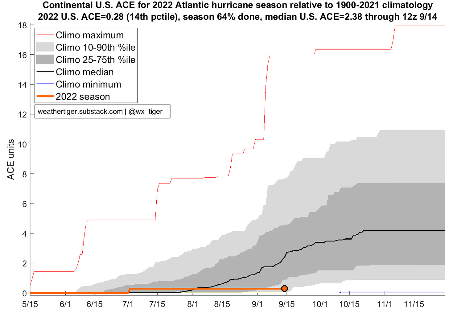
You see, whenever I pull overtime for hurricane threats, the detritus from the naturally essenced sparkling water that underpins every WeatherTiger forecast is added to an aluminum edifice. Each of the last six years, the can pyramid has risen by September to formidable, Kool Aid Man-tempting heights; this year, it’s thankfully a wimpy trapezoid of just five cans.
In the upcoming week, there is a slight chance of stacking some pamplemousse, as newly formed Tropical Depression Seven bears watching for the Southeast U.S. coast. However, the most likely outcome is TD 7 remaining well east of Florida, with little additional LaCroix activity.
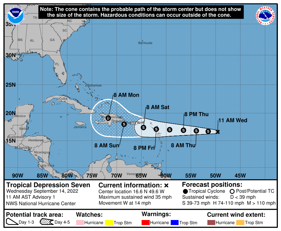
As of Wednesday afternoon, Tropical Depression Seven is located a little less than 1,000 miles east-southeast of Puerto Rico, moving west at about 15 mph. Maximum sustained winds are around 35 mph, and TD 7 is likely to become Tropical Storm Fiona by late Thursday. A westward motion is expected to continue into the weekend, and the system will cross near or over the northern Lesser Antilles on Friday, Puerto Rico by late Saturday, and Hispaniola late Sunday or early Monday.
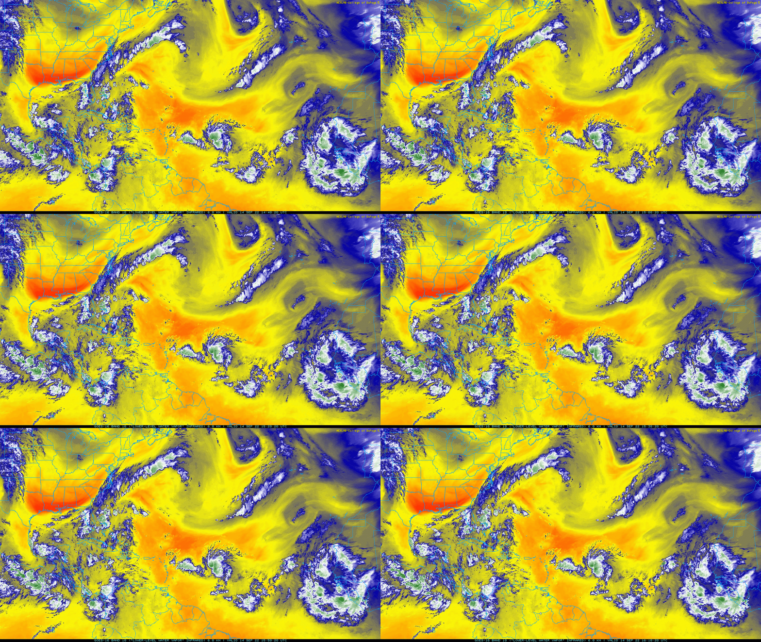
The good news is there’s not much upside to the intensity forecast. A very dry airmass two to four miles off the ground is lurking just to the depression’s west, and shear out of the southwest is periodically pushing that arid air over the developing circulation center. That combination should keep a well-defined core from developing before the storm reaches the Greater Antilles, probably limiting potential Fiona to low-end tropical storm intensity through Sunday. Nevertheless, gusty coastal winds and 3-6” of rainfall with locally higher totals are expected in the northern Lesser Antilles, Puerto Rico, and Hispaniola this weekend.
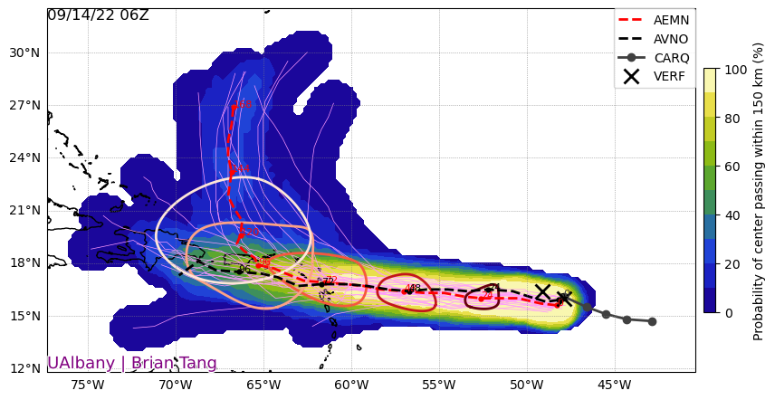
The longer-term prognosis for TD 7 is uncertain. The odds of the storm being a major problem for the U.S. down the road are low, but non-zero. If the system remains sheared and shambolic, interaction with the mountains of Puerto Rico and Hispaniola could weaken it further, with a remnant tropical wave then continuing west into the western Caribbean. If TD 7 is a little more organized, with low- and mid-level circulations more stacked on top of each other, the storm will likely turn to the northwest early next week, and possibly be in the general vicinity of the Turks and Caicos Islands by Tuesday. There are also some hints of a bit more favorable environment around that time should TD 7 reach the area.
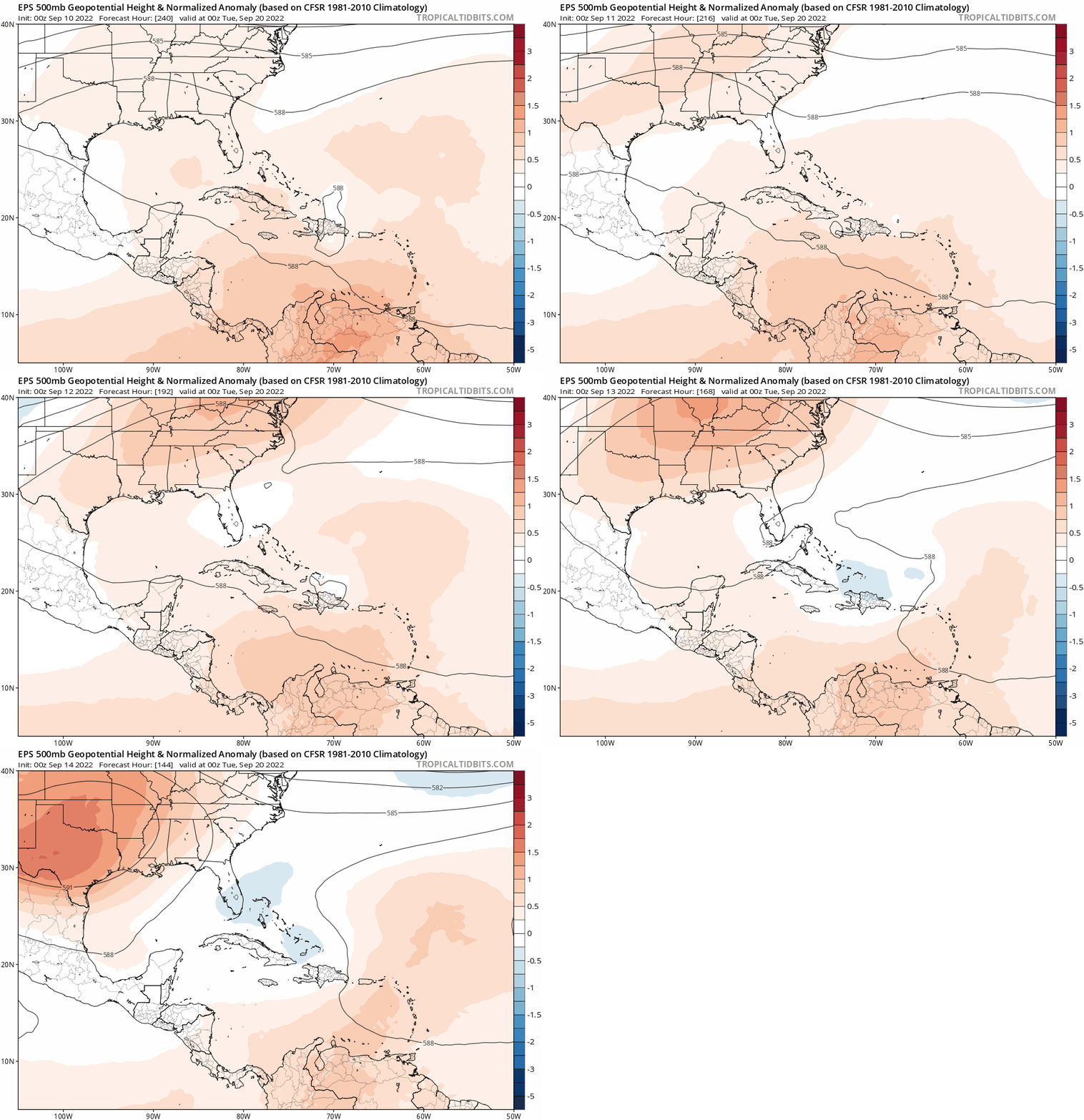
I had mentioned last week that the steering winds over the eastern U.S. were somewhat worrisome heading into the second half of September, and that there was at least a slight possibility of the overlap between means (storm activity) and opportunity (steering winds) necessary for a threat. While the prospect of means has firmed up with the development of TD 7, the opportunity has diminished. Models now suggest that a ridge of high pressure will be centered over the Southern Plains rather than the Southeastern U.S. in 6 to 10 days, which would allow a dip in the jet stream over the western Atlantic to turn a stronger potential Fiona to the north, rather than keep it tracking generally westward.
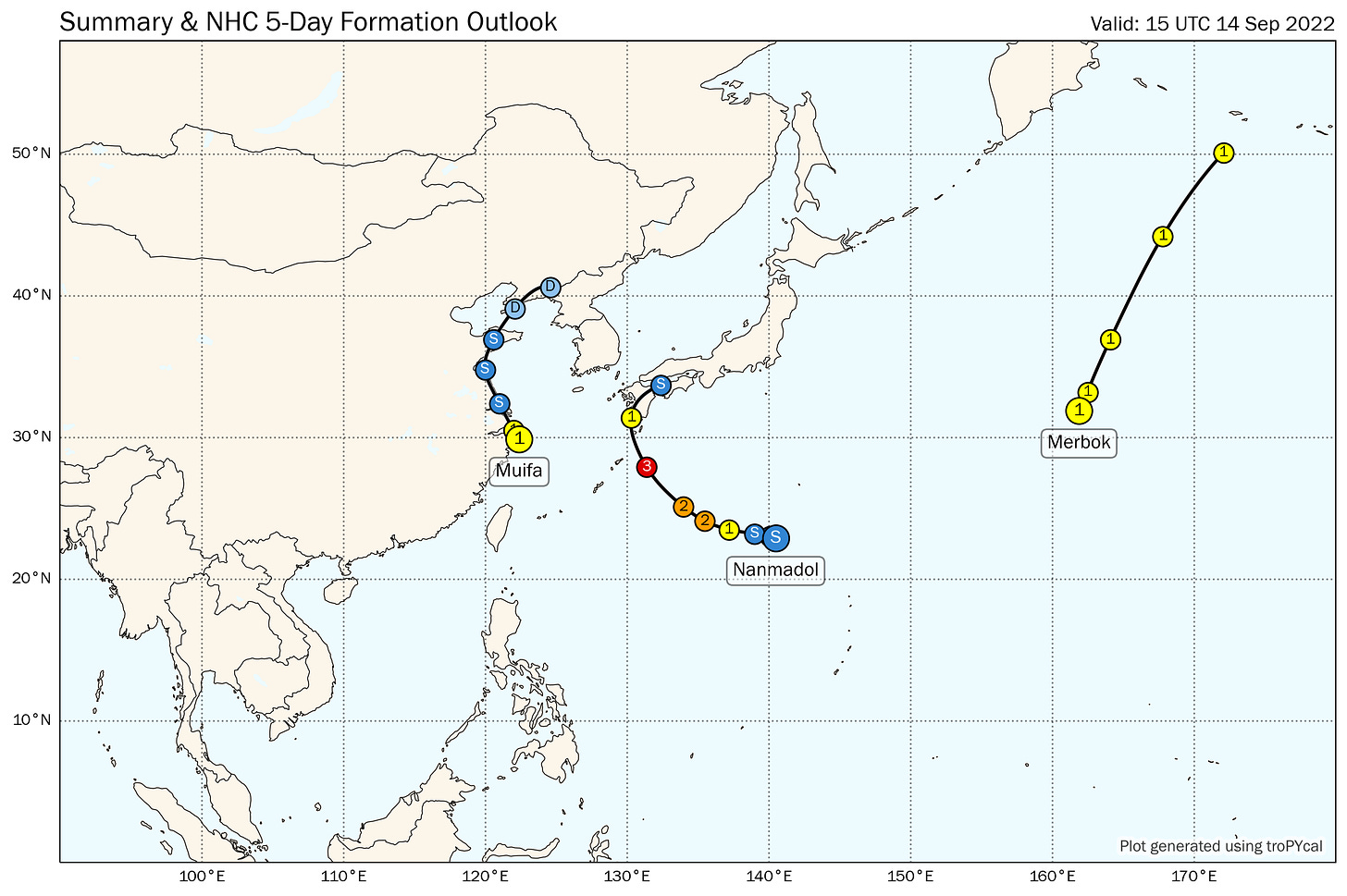
Still, while either dissipation or a track offshore are the most probable outcomes with TD 7, forecast uncertainty is high. Model guidance has been jumping around quite a bit over the last few days, and there is still time for next week’s steering wind forecasts to change yet again. The predictability of the jet stream pattern is much lower than normal following the entrance of Western Pacific typhoons into the mid-latitudes, and two or three such events are likely in the next week. (That includes Typhoon Merbok, which will be undergoing extratropical transition while crossing the far western Aleutian Islands in a few days, so you can add Alaska to southern California and western France as regions seeing more indirect tropical cyclone impacts than Florida so far in 2022.)
The bottom line is TD 7 isn’t an imminent threat to Florida or the U.S. coastline as it stands, but there are also reasons why that could change over the next 10 days and I wouldn’t write it off entirely. Heck, North Florida is already receiving oddly pleasant weather, with a few blessed days of dewpoints ahead in which sweat has a rare chance of evaporating. Expect the unexpected.
In a typical mid-September, the hurricane lilies are coming up, the beautyberries are a nuclear shade of purple, and the WeatherTiger LaCroix pyramid is as high as an elephant’s eye. To quote Meat Loaf, two out of three ain’t bad. I’ll be hoping it stays that way this week as the TD 7 forecast evolves. Keep watching the skies.


Pics of the LaCroix pyramid or it didn’t happen!