Giving Off Sparks: The WeatherTiger Newsletter for April 2024
Breaking down the total eclipse cloud cover prognosis as hyperactive hurricane season outlooks continue rolling in.
Enjoy this free sample of WeatherTiger’s monthly subscriber newsletter, which keeps our supporters informed on key developments in the weather world during the hurricane off-season. And don’t forget to read our 2024 Hurricane Season Outlook and sign up below for free hurricane coverage all season long.
Mood music:
A shadow on me: Eclipse weather forecast
For the second time in seven years, solar eclipse mania has seized the nation, and even the planet itself quakes in anticipation. And with good reason: the opportunity to see a literal black hole sun, the delicate beauty of the corona, and 360 degrees of twilight dark in the middle of the day comes but for a few minutes each generation, and is not to return to much of the United States until 2045.
Unfortunately, it takes three to tango, with the dance of the sun and moon requiring co-operation from the weather for the spectacle to be observed in its full, spectacular glory. As I was making plans last year, I researched the cloud cover climatology for early April along the path of totality (top panel, below) to help choose an ideal viewing location. However, climate is what you expect and weather is what you get, and the actual National Weather Service cloud coverage forecast map (bottom panel, below) for Monday at 2 p.m. Eastern is almost diametrically different from climatology.
While clouds are notoriously capricious to forecast, as of Friday afternoon the best outlook for clear skies is in northern New England, where the last 30 years of cloud data would predict the lowest chance of high eclipse visibility. (Dim, damp, brooding April in the Northeast is National Poetry Month for a reason.) The opposite is true in Texas north to central Arkansas, where April is historically sunnier, but an upper-level disturbance will be kicking up low clouds and rain chances. The Midwest is a mixed bag, with a generally positive prognosis from Missouri into eastern Ohio with some risk of high clouds, and broken but extensive frontal cloud cover in the eastern Great Lakes. Updated NWS forecasts and a nifty city-by-city ensemble cloud forecast dashboard can be found at Dr. Tomer Burg’s eclipse site here.
Fortunately I opted against Texas for logistical reasons, and the WeatherTiger Eclipse Intercept Research Deployment (W.E.I.R.D.) is rolling out tomorrow for the Lower Midwest to catch the cosmic ballet in its celestial majesty. I’ll be basing out of the Missouri Bootheel, but my tentative target is the Alpacalipse festival at Rolling Oaks Alpaca Ranch in Makanda, Illinois. While I hope to enjoy the once-in-a-lifetime opportunity to partake of the Universe’s #1 spectacle in the presence of Earth’s #1 ungulate, the wise eclipse chaser stays nimble; a last minute dash from Charleston to Columbia was necessary to catch cloudless totality in 2017. We’ll see where the road takes the W.E.I.R.D. team, including eclipse veteran WeatherCub and chase newbie WeatherCubette, on Monday.
Finally, if you enjoyed Willie’s mood music, our full AlpacEclipse 2024 ULTIMIX playlist can be sampled here, incorporating astronomical hits as well as regional bangers appropriate for meandering Illinois’ “Little Egypt” region.
Powder keg: Hurricane season outlook update
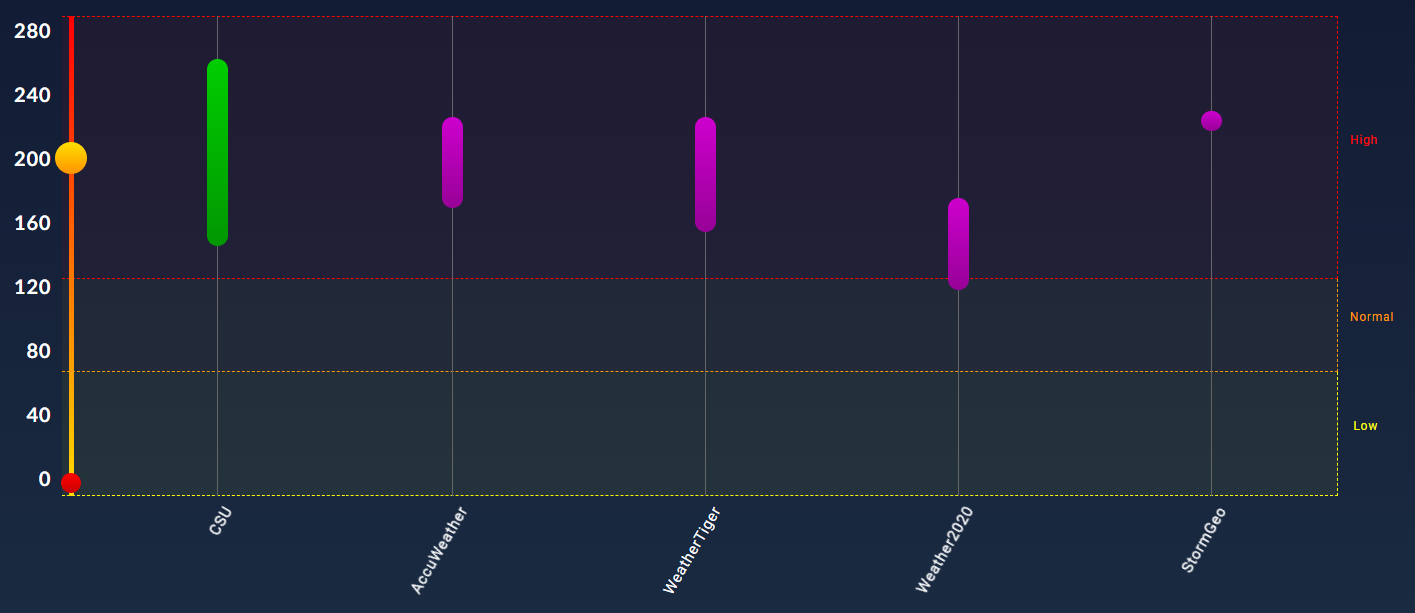
WeatherTiger’s initial 2024 hurricane season outlook has been out for two weeks, and in that time, evidence continues to stack up favoring an active season. We’re no longer alone in calling for a probable hyperactive season, though we continue to be the only seasonal outlook tapping into the allegorical potential of the Big Dogs lifestyle. On Thursday, Colorado State’s outlook was even higher than ours at ~210 Accumulated Cyclone Energy (ACE) units, and this morning, the European Center’s model-based forecast also came in around 210-215 ACE units as a starting point. In fact, as shown below, all the reputable seasonal outlooks released so far as indexed by seasonalhurricanepredictions.org are tilting well above normal.
I’m currently running WeatherTiger’s real-time model internally to shake any bugs out of the system before daily updates for clients resume in early May. Suffice to say, there has been very little change to our model’s numbers over the last two weeks, with our most likely ACE remaining near 195 and no shift in elevated U.S. landfall odds.
Only falling apart: April ENSO Whisperer forecast
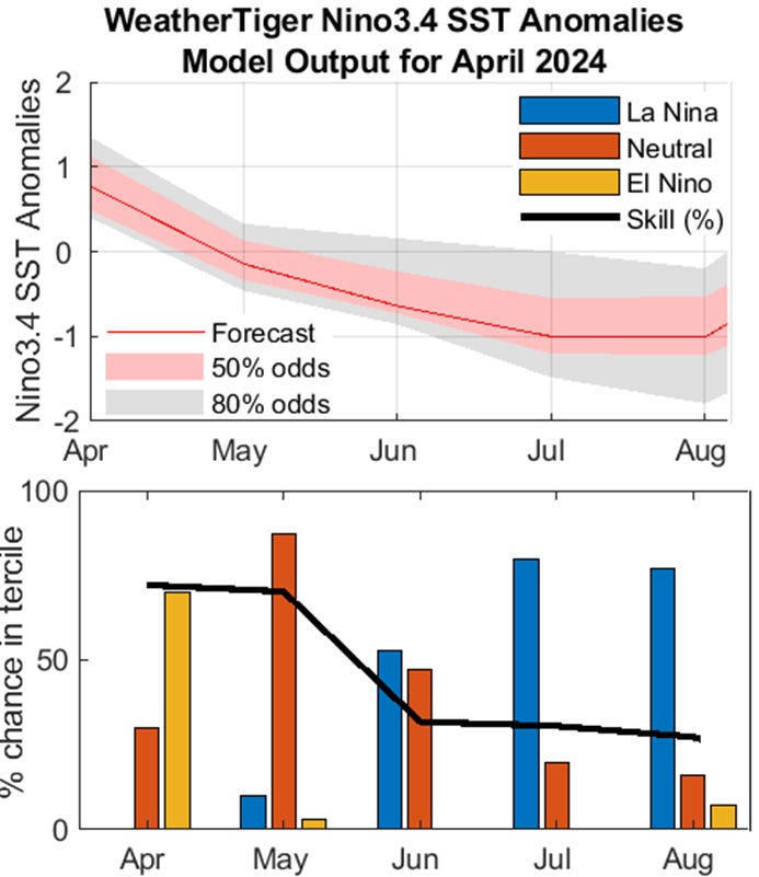
WeatherTiger’s in-house El Nino/La Nina modeling has been consistent in predicting the demise of El Nino in the next four to six weeks. El Nino is currently enjoying one final pop thanks to a period of weak trade winds, but colder waters beneath the surface are likely to rise and return the Pacific to neutral conditions in May.
Our model continues to show about a 75% chance of La Nina developing by July, little changed from last month, and that the most likely outcome is a borderline weak/moderate La Nina in place heading into the August-October heart of hurricane season. Even if La Nina is slower to develop, as the European model suggests, it is very unlikely that ENSO will exercise a significant drag on Atlantic tropical activity.
Turn around: Florida temperature/precip forecast
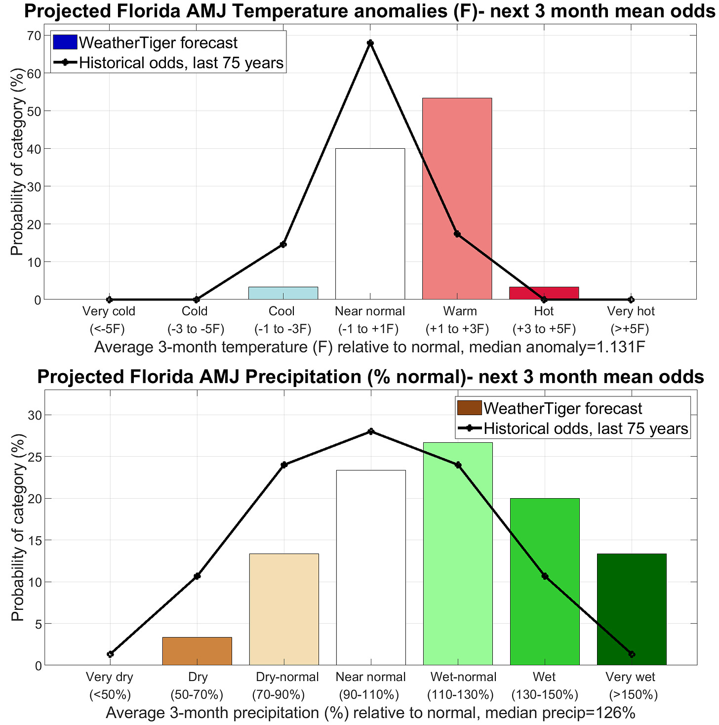
Though El Nino is likely to dissipate in the near future, its influence will not vanish overnight. This means that through the end of June, there is about a 60% chance of wetter than normal conditions, with 20-25% and 10-15% chances of near- or below-normal precipitation, respectively, for Florida as a whole, with a most likely outcome of about 25% more rain than normal over the next 3 months. The caveat here is that those rains might be front-loaded in the spring: a fast Nino>Nina transition means an underperforming thunderstorm season in Florida, so gather ye rains while ye may.
On the other hand, the coolish expectations for early spring are waning into summer, with about a 40% chance of average April-June temperatures within a degree of normal and a 60% chance of temps more than 1F above normal. As the season in which cold fronts are in the realm of possibility comes to a close, surrounding water temperatures and subtropical ridge positioning take pre-eminence in influencing Florida’s temperature profile, and both suggest a warmer than average tilt into June.
End of the line: Next reports schedule
In the end matters of last month’s newsletter, I promised to take a look at the doings at the World Meteorological Organization regional hurricane meeting, which took place in March. Not a lot of headlines to report from this year’s meeting— the key takeaway is that Idalia was not retired, and thus will return on the 2029 name list. The 2023 Atlantic hurricane season is thus the first year to not have a name retired since 2014, which is fortunate because not only does it mean Idalia’s impacts were limited, but also that the critical shortage of female “I” names will not worsen, at least for now.
Anyway, expect the next monthly newsletter update in the first week of May, and our updated hurricane season outlook on May 22. In the meantime, if you’re chasing the eclipse, here’s wishing you 100% positive alpaca energy to keep watching the 100% clear skies.


Update: The threat of mid-level clouds sent the WeatherTiger intercept team south to Cave City, Arkansas on Monday, so no eclipse alpacas. But we had a cloudless view of all 4 minutes and 9 seconds of totality.
Ryan, what is ENSO ?
Mark Hoffman