


Final Lee: Hurricane Lee Updated Impacts Forecast for September 15th
Lee is on approach to eastern New England and Atlantic Canada. These are the updated wind, surge, wave, and rain impacts in the forecast.
Florida tropical threat synopsis: High seas, rip currents, and beach erosion from Hurricane Lee will persist on the Atlantic coast for two more days before subsiding. Otherwise, a stalled frontal boundary east of Florida will be worth keeping an eye on in 7-10 days.
Almanac: It’s Friday, September 15th… day 106 of the 2023 hurricane season, 77 days to go. By total storm energy, the season is 54.7%, 64.5%, and 53% complete for the Atlantic, continental U.S., and Florida.
Heading into the second half of September, tropical storm development continues to be evenly distributed across the Atlantic Basin, including the eastern Main Development between West Africa and the Lesser Antilles. However, the rate of development in this region typically begins to slow towards the end of the month.
Active Storms:
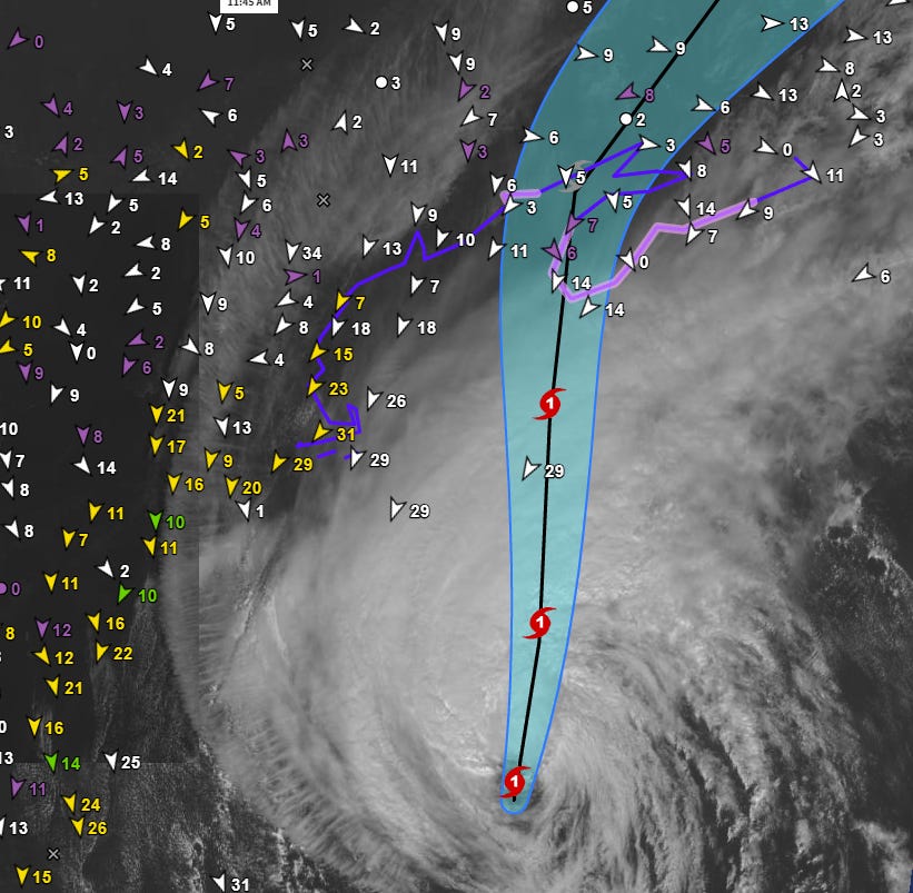
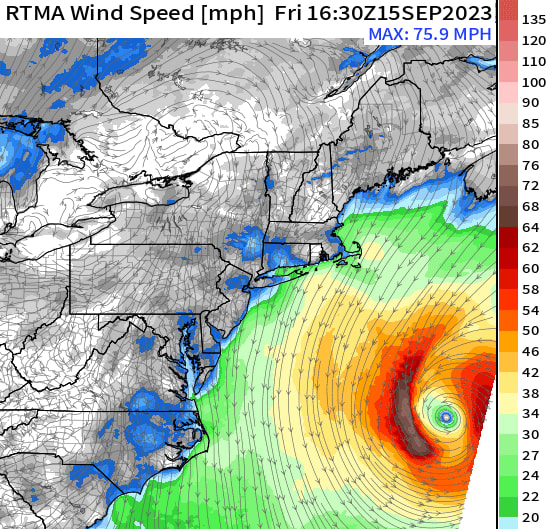
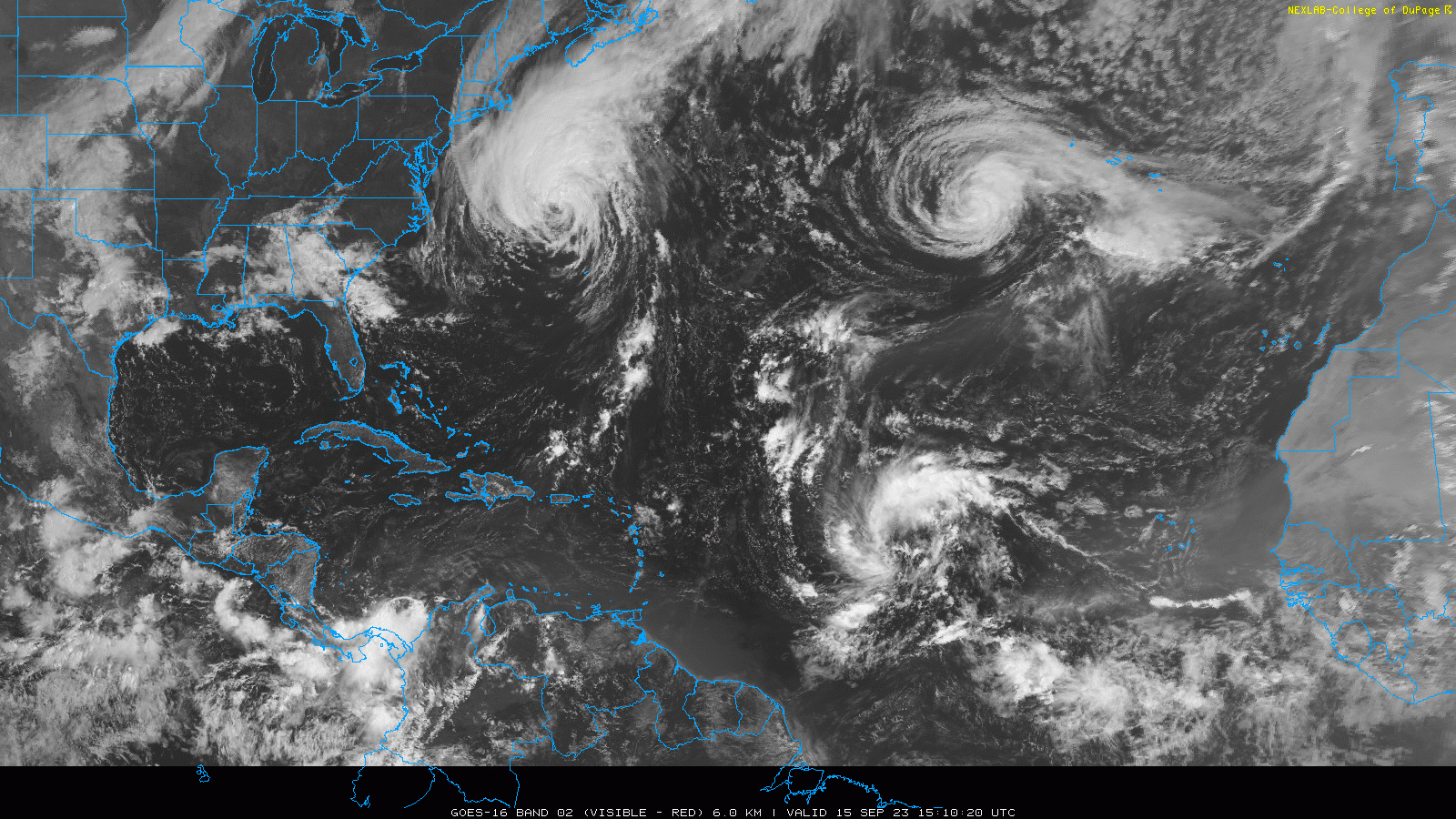
Hurricane Lee is plowing north today at around 20 mph, with maximum sustained winds down to 80 mph as of the 11 a.m. NHC advisory. As Lee spreads out further while beginning to transition to a non-tropical cyclone, the more pertinent numbers for this hurricane remain the wind radii, which are still exceptionally large: the region of tropical-storm-force winds is over 575 miles in diameter, and the region of hurricane-force winds is still 175 miles in diameter, even as the max winds decline.

Current sustained wind fields as of Friday afternoon. The NHC forecast track and intensity are essentially unchanged since yesterday. Lee will move into the Gulf of Maine around 200 miles east of Cape Cod tomorrow morning and then across Nova Scotia and New Brunswick as a hybrid low tomorrow evening. As there is little change to the broad strokes of the forecast, I’m going to refer you back to yesterday’s bulletin for a more detailed discussion of impacts. Instead, I’m simply going to update wind, surge, wave, and rain expectations relative to that baseline today.
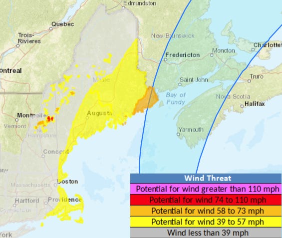
In wind terms, Lee continues to look like just a blustery and gusty day for most of New England. Look for 40-60 mph winds along the coast north of Rhode Island, and the potential for 60+ mph gusts in eastern Maine and Cape Cod. The region of these stronger winds has retreated east since yesterday.
![[Image of cumulative wind history]](https://substackcdn.com/image/fetch/w_1456,c_limit,f_auto,q_auto:good,fl_progressive:steep/https%3A%2F%2Fsubstack-post-media.s3.amazonaws.com%2Fpublic%2Fimages%2Fc5b505c1-64d8-4496-8613-5d7ce0c67804_897x736.png "[Image of cumulative wind history]")
There have also been modestly positive changes to the U.S. surge forecast, with the Storm Surge Watch for Cape Cod Bay dropped as peak surge expectations there have dropped from 2-4’ to 1-3’. Surge of 3-6’+ remains likely along and right of the track in Atlantic Canada, so monitor statements from the Canadian Hurricane Center for additional details.

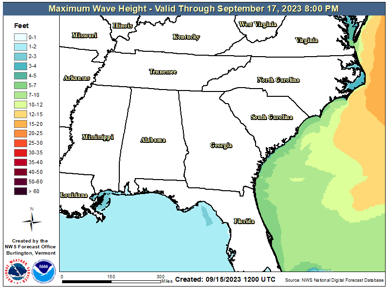
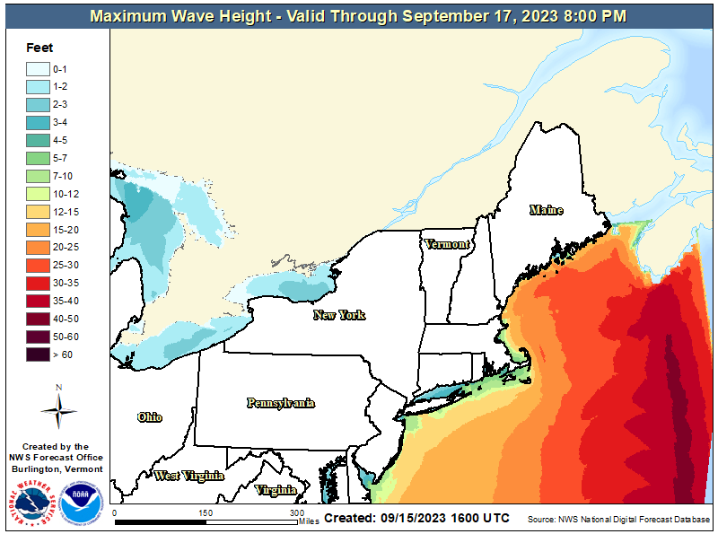
Maximum expected wave action in the Gulf of Maine is unchanged since yesterday, at anywhere from 15-25’. The highest seas of 25-40’ will be pointed at western Nova Scotia.
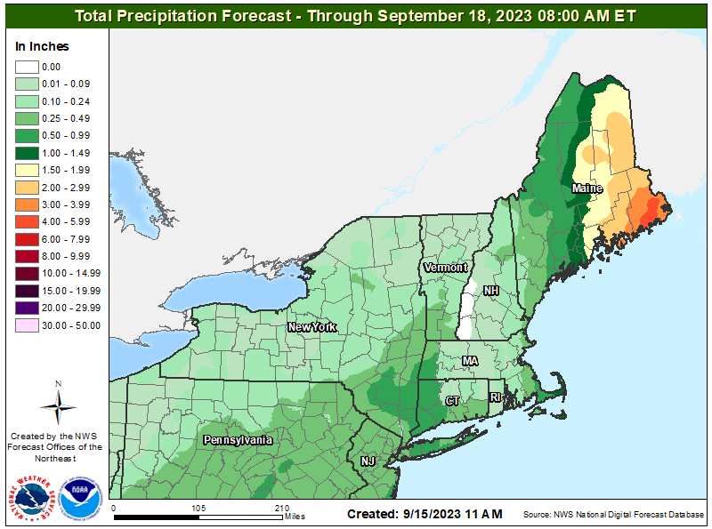
Finally, rainfall expectations have ticked down a bit for much of New England in the last 24 hours, and Boston and vicinity will see occasional showers tomorrow morning into early afternoon, totaling less than 1”. Rainfall of 1-4” and more widespread flash flood potential will be limited to eastern Maine in the U.S., and New Brunswick and western Nova Scotia in Atlantic Canada.
![[Image of WPC Flash Flooding/Excessive Rainfall Outlook]](https://substackcdn.com/image/fetch/w_1456,c_limit,f_auto,q_auto:good,fl_lossy/https%3A%2F%2Fsubstack-post-media.s3.amazonaws.com%2Fpublic%2Fimages%2Fd7a0f2a5-d7bb-4bd1-9f37-302241f2eba8_892x716.gif "[Image of WPC Flash Flooding/Excessive Rainfall Outlook]")
Bottom line, Lee will be a glancing blow for New England, with widespread but manageable impacts on the U.S. coastline. The story may well be different in Atlantic Canada, where the combined surge and wave impacts could be severe where local geography funnels a massive influx of water into narrow channels.
Tropical Storm Margot has weakened since yesterday well west of the Azores, with sustained winds now down to 65 mph. Margot will weaken further as it whirls about in the open Atlantic for the next 3-4 days, then will likely accelerate east towards the Azores by the middle of next week.
As of 11 a.m., newly developed Tropical Depression 15 has formed about 1,000 miles east of the Lesser Antilles. TD 15 already moving northwest and will continue to do so over the next 5 days, heading in the general direction of Bermuda as it becomes Tropical Storm and then Hurricane Nigel. The NHC intensity forecast is quite aggressive, bringing TD 15 to a major hurricane by Tuesday, as supported by most dynamical models and a favorable shear, moisture, and SST environment in the Subtropics. This storm is definitely one to watch for interests in Bermuda, but is no threat to the U.S. or even Atlantic Canada.

![[Image of cumulative wind history]](https://substackcdn.com/image/fetch/f_auto,q_auto:good,fl_progressive:steep/https%3A%2F%2Fsubstack-post-media.s3.amazonaws.com%2Fpublic%2Fimages%2Fc5b505c1-64d8-4496-8613-5d7ce0c67804_897x736.png "[Image of cumulative wind history]")

![[Image of WPC Flash Flooding/Excessive Rainfall Outlook]](https://substackcdn.com/image/fetch/f_auto,q_auto:good,fl_progressive:steep/https%3A%2F%2Fsubstack-post-media.s3.amazonaws.com%2Fpublic%2Fimages%2Fd7a0f2a5-d7bb-4bd1-9f37-302241f2eba8_892x716.gif "[Image of WPC Flash Flooding/Excessive Rainfall Outlook]")
Other disturbances in NHC outlook, with 2-/7-day NHC development odds: A tropical wave will roll west off the African coast by early next week, and the NHC is giving it a 20% chance of becoming a depression in 5-7 days. Model support for development is pretty robust for this range, and given the successful track record of recent tropical waves, it’s tough to bet against eventual development.
Elsewhere: No other features of note in the Atlantic today. A front will push across Florida in 4-5 days, bringing some relief from continued summer-like conditions next week. However, we’ll need to watch to see if low pressure tries to develop east of Florida along the stationary boundary once it stalls out over warm water late next week, as the GFS and Euro both hint. No cause for concern at this time, as conditions do not appear favorable for a strong storm to develop, if anything at all gets going.
Next report: Daily bulletin out Monday morning for subscribers.
As always, very good update!
With regards to hurricane development in the Western Caribbean region, what months are more prone to this activity? The way Idalia popped into existence scared the pants off me.