Fairytale of New Jersey: The WeatherTiger Newsletter for December 2024
Looking ahead to what 2025 may have in store for La Nina, Florida weather, and hurricane/drone activity.
Enjoy this free sample of WeatherTiger’s monthly off-season newsletter, with an exclusive preview of the 2025 hurricane season. Also, all annual subscriptions, including gifts, are 24% off through the end of 2024— click below to take advantage of this once-a-year deal.
A quick look ahead to the 2025 hurricane season
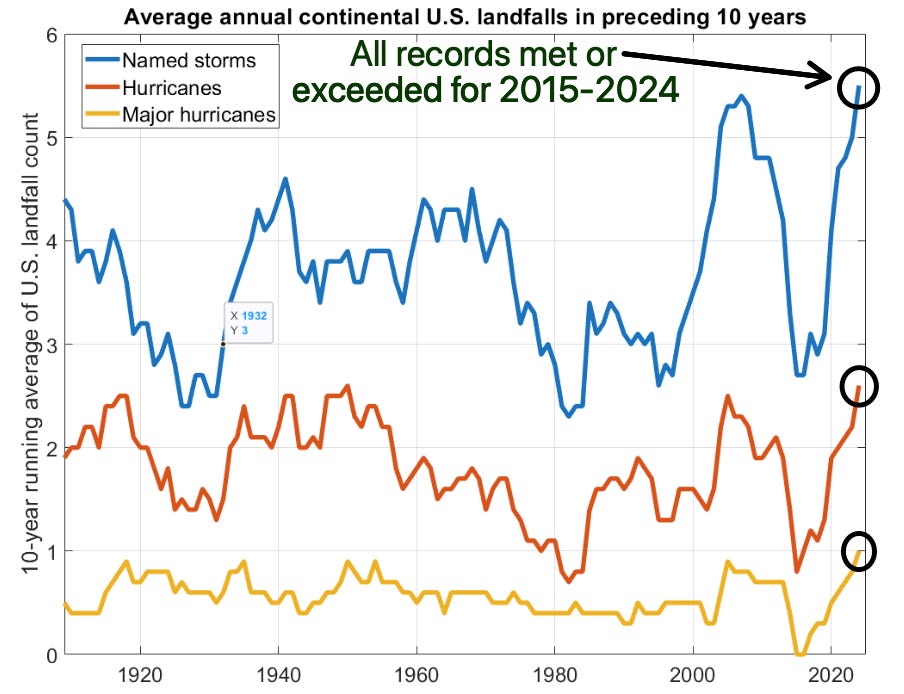
If you’re still exhausted by the 2024 hurricane season and in no mood to interrogate 2025, well, I’m right with you, with my mind still in self-cleaning mode in the wake of this rough year. As I detailed in the 2024 review, the five continental U.S. hurricane and two major hurricane landfalls this year stand toe-to-toe with the worst seasons on record, with dollar damages only exceeded by 2017. Zooming out even further, the last decade has been historically impactful for the continental United States. In fact, the number of CONUS named storm (55), hurricane (26), and major hurricane (10) landfalls occurring since 2015 are all the highest 10-year totals going back to the beginning of reliable records in 1900. Coming on the heels of a remarkably quiet period between 2006 and 2015, I think we could all use some bedrest for whiplash. Unfortunately, I cannot recommend the Netflix original film Hot Frosty as convalescence viewing, as it is simply not very good.
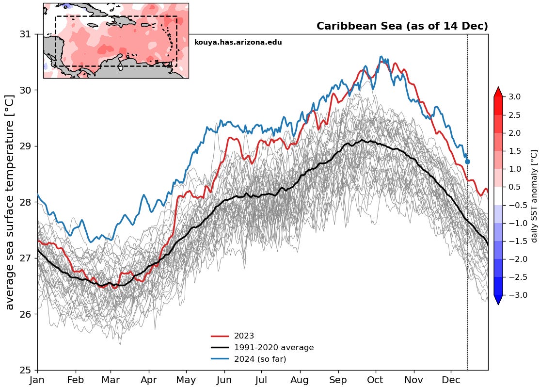
Nevertheless, time’s arrow neither stands still nor reverses, and there’s already chatter about the potential for another busy hurricane season in 2025. This conversation is primarily driven by the Tropical Atlantic remaining much warmer than average even after a hyperactive 2024, with only 2023 a comparable analog in terms of widespread anomalous warmth. However, the overall vibe contemplating the season ahead is a bit less apocalyptic than this time last year due to El Nino/La Nina considerations. As a reminder, whether La Nina or El Nino is active during the peak of hurricane season plays a huge role in modulating U.S. landfall risks, with major hurricane landfalls three times more frequent during La Nina versus El Nino seasons.
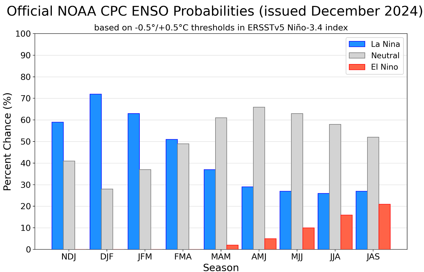
The 2024 hurricane season did not take place during an officially declared La Nina, but overall atmospheric conditions in the late summer and fall were the effective equivalent of at least a weak La Nina. If you’re counting, that makes four of the last five years as being dominated by Nina influences, which likely has played a key role setting in the rapid tempo of U.S. landfalls. While the skill of El Nino/La Nina forecasts beyond the “spring predictability barrier” is poor, the good news is that it is quite unlikely that summer 2025 will bring yet another Groundhog Nina. Since 1950, there are only three other cases in which the Oceanic Nino Index has been below -0.5C in four of the five previous December-February averaging periods (1972-1976, 1997-2001, and 2008-2012); in all three instances, the following summer and fall saw neutral conditions, with neither an El Nino nor La Nina ongoing.
Just for fun, it’s worth noting that the 1976, 2001, and 2012 hurricane seasons averaged “only” about 15% more Accumulated Cyclone Energy (~110 ACE) than the median year since 1950 (~95 ACE). That’s not exactly a robust sample, but taking La Nina out of the mix does help diminish the odds of a hyperactive season, as non-Nina years have less of a tendency for continued hurricane activity into late October and November.
If I had to make a way-too-early guess of how the 2025 Atlantic hurricane season will play out, I’d say there’s about a 40% chance of ACE landing in the top third of seasons since 1950, a 40% chance of middle third ACE, and a 20% chance of bottom third ACE. In other words, while I’d love for things to be so boring next year that I have to review and rate Kirkland products and tactical flashlights to generate newsletter content, don’t count on it. I’ll have a more formal outlook for the season in March.
The ENSO whisperer
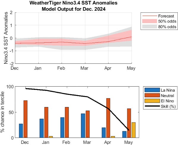
As shown above, a key influence on next hurricane season will be how quickly the winter 2024-25 La Nina, likely to be peaking over the next couple of months, fades out in the spring and early summer. WeatherTiger’s ENSO Whisperer model run for December shows La Nina is likely to weaken in February or March, with a most probable return of neutral ENSO conditions by April. Pretty much all other reliable guidance shows a neutral late spring, though some have a brief stronger Nina peak.
The bigger question is whether El Nino will develop over the summer and fall. Right now, that’s not showing up in WeatherTiger’s model, which runs through May. All seven of the seasonal climate models included in the North American Multi-Model Ensemble are in neutral territory at the end of the run in July, as the slim roster of analog years would also suggest. Nevertheless, I’ll be watching ENSO carefully through the off-season, as faster Nino development would increase the odds of a quieter 2025 Atlantic hurricane season, especially in U.S. landfall terms.
For Florida specifically…
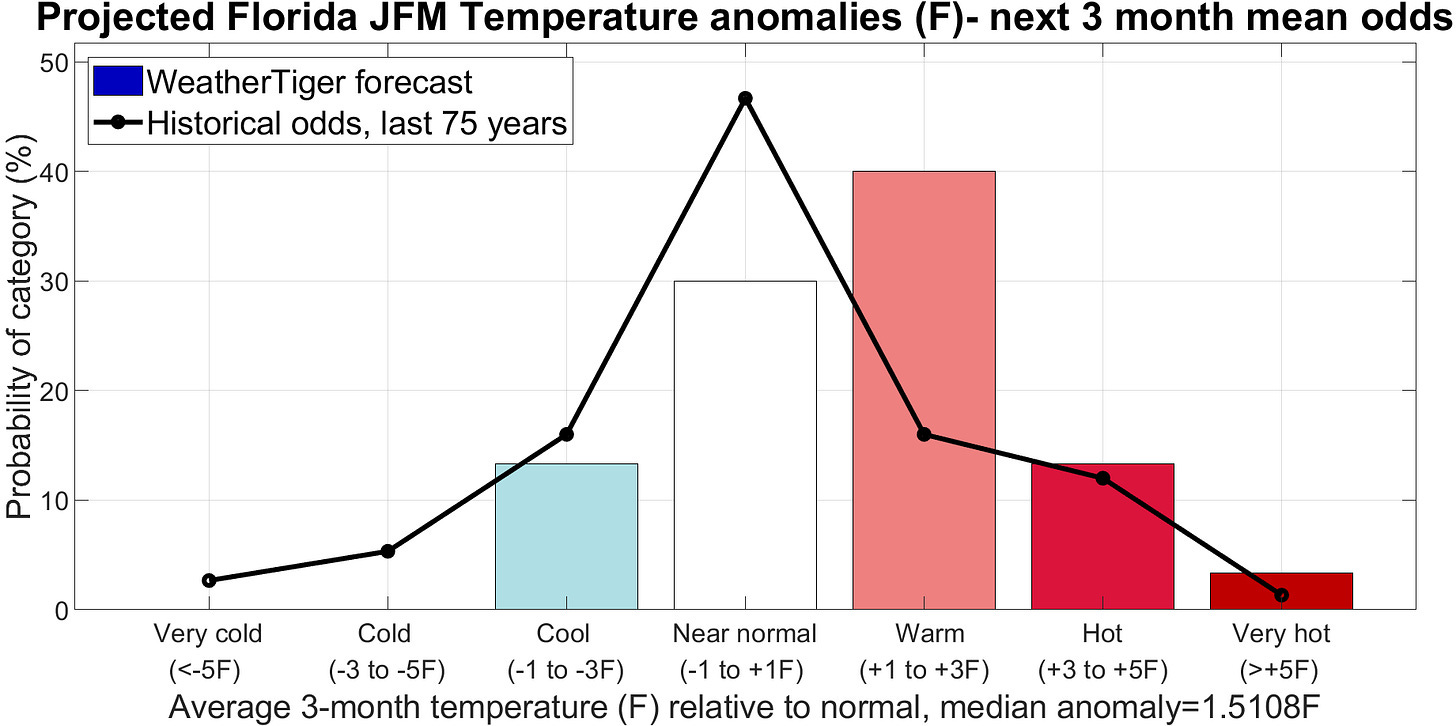
As the short-term forecast augurs, the first quarter of 2025 likely will be warm and dry in Florida, befitting the familiar, obnoxious rhythms of yet another La Nina winter. WeatherTiger’s model for January-February-March (JFM) average temperatures in Florida relative to normal calls for around a 30% chance of temps within 1F of average, with a 15% chance of cooler than normal and 55% chance of warmer than average temperatures. The best chance of an extended run of colder than normal temperatures is likely sometime in the January 5th to 20th range. I’d expect a warmer February and early spring.
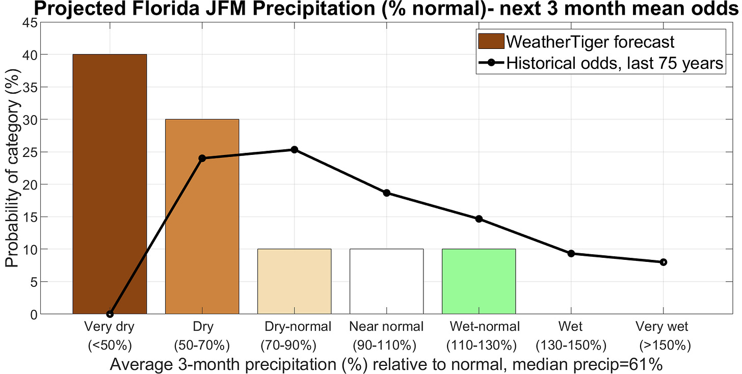
In terms of rainfall, Florida is already hurting for precipitation, especially in the southern half of the state. There’s no good news to be had here over the next three months, with below-normal rainfall overwhelmingly likely through March. There is about a 10% chance of above average rainfall, a 10% chance of near average rainfall, and an 80% chance of drier than normal conditions between January and March. Florida as a whole is most likely to see about 60% of typical winter and early spring rainfall. Precip prospects may improve deeper in spring as La Nina’s grip loosens.
#1 Christmas Mood Music
Finally, like a wayward Magi who followed mysterious drone lights westward to New Jersey and was promptly mugged for his gold, you may find yourself in need of a gift this holiday season. WeatherTiger has you covered! Share the gift of expert analysis of Florida hurricane threats with a twist of dad humor via a one-year gift subscription, now a whopping 24% off. Click below to access the sale, which ends on December 31st.
And so, dear reader, here’s offering a final thanks for your support in 2024. I’ll see you in 2025 for what we can only hope will be a kinder, gentler hurricane season. In the meantime, may your holidays shine with the luster of a Costco gold bar and the blinding brilliance of a tactical flashlight, and keep watching the skies.



This morning, I was looking at the lined parka from LL Bean in my closet. Bought it in the early 2000's for dog walking on cold mornings. Remembering frozen pump station bubbler pumps on Siesta Key. A touch of snow one night in Southern Manatee at a Christmas party with my wife and a November a few years before Covid with temperatures in the 40's every night for a month. Don't think we will ever see those days again.
Best wishes to you and your family and again thanks for doing this for us.
John
Thank you again for broadening my weather knowledge & also my musical experience!!
Happy Holidays!!