Encyclopedia Atlantica: Hurricane Watch Weekly Column for June 27th
In a well-deserved lull, defining some of tropical forecasting's many vocab words.
WeatherTiger’s Hurricane Watch is a reader-supported publication. Paid subscribers get Florida-focused tropical briefings each weekday, plus weekly columns, full coverage of every hurricane threat, our exclusive real-time seasonal forecast model, and the ability to comment and ask questions for $49.99 per year.
Like Amelia Bedelia sitting on a watch so she can be on time, hurricane jargon can be baffling and opaque to the uninitiated. Here at WeatherTiger, we prize clarity and oppose misunderstandings, even hilariously literal ones; however, there are certain unavoidable bits of meteorological vocab needed to communicate forecasts pithily. Therefore, I’m taking advantage of a quiet Atlantic to put together this overdue clip-n-save guide to basic tropical terminology. Prepare to ace your MSATs, and to no longer need to email me asking what ACE means.
Tropical cyclone: A special type of low-pressure system forming over tropical or subtropical oceans. Distinguished from other storms by having a closed cyclonic circulation, no connection to fronts, a “warm core” aloft, organized and persistent convection, and a well-defined surface center. If it doesn’t have all five, it isn’t a tropical cyclone.
Atlantic Basin: A catch-all term for the areas where tropical cyclones can develop, including the Gulf of Mexico, Caribbean Sea, and open Atlantic waters.

Climatology: The history of weather, used to understand what “normal” means. To account for new observing technologies and data trends, climatology is typically defined over a 30- or 50-year base period and can change with time, the way Indiana Jones’ first movie is set in the 1930s and the new one has him searching for Taylor Swift’s lost Scarf of Destiny. It belongs in a museum!
Tropical wave: A westward-moving disturbance that sometimes develops into a tropical cyclone. Waves show cyclonic turning or curvature in low-level winds, but no closed circulation with winds from all compass points around a single center.
Vertical wind shear: A change in the direction or strength of wind with height. For instance, if low-level winds are out of the west at 10 knots, and upper-level winds are out of the east at 20 knots, that adds up to 30 knots of wind shear. In the same way blowing lightly on a candle makes it burn brighter but blowing hard extinguishes it, wind shear of less than 15 knots can help a hurricane by ventilating it, while more than 20-25 knots of shear weakens storms and makes development unlikely.
Convection: Air rising quickly through the atmosphere, often resulting in tall clouds, intense storms, and heavy precipitation in the humid Tropics. Nearly synonymous with thunderstorm activity, though tropical cyclones often do not produce much lightning.
Saharan Air Layer (SAL): Suspended sand and dust particles one to three miles up in the atmosphere caused by east-to-west winds blowing off the Sahara Desert. Unfavorable for tropical development because the dust absorbs sunlight and warms the middle atmosphere, reducing convective potential.
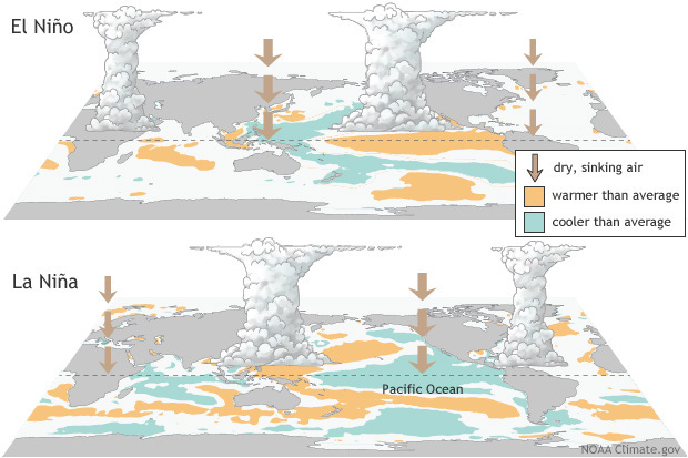
El Niño: Abnormally warm waters in the Equatorial Pacific in the general vicinity of the International Date Line. A key driver of weather patterns worldwide, including higher wind shear in the Tropical Atlantic.
Accumulated cyclone energy (ACE): A way of measuring the sum of tropical cyclone intensity over time. ACE is calculated by squaring a storm’s maximum wind speed (in knots) each six hours, dividing by 10,000, and then summing over the life of the storm or an entire season. A tropical storm produces about half to one ACE unit per day, while a major hurricane produces four or more ACE units per day.
Sea surface temperature anomaly: The difference between the current temperature of the top layer of the ocean and its normal temperature, with normal usually defined as a 30-year average for a particular location and date.
Keep watching the skies: The last line of the 1951 B-movie The Thing from Another World, a prescient warning of the dangers of alien carnivorous plants.
Got it? Good! Now you can appreciate the following forecast on a deeper level, like someone at a cocktail party loudly opining that The Wizard of Oz is really an allegory to late 19th Century monetary policy.
There are no tropical cyclones today in the Atlantic Basin as the environment reverts to unfavorable conditions more typical of midsummer climatology. The only disturbance of note is the remnants of Tropical Storm Cindy, now turning north towards Bermuda. Cindy opened to a tropical wave on Sunday in response to strong vertical wind shear east of the Lesser Antilles; however, convection is starting to creep a little closer to Cindy’s erstwhile center, and there is a slight chance of it regaining tropical storm status before Friday as it approaches eastern Canada. No threat to the U.S. coast.
Elsewhere, the Atlantic is calm, as strong shear controls the western half of the Basin and a Saharan Air Layer overspreads much of the eastern half. These conditions should persist and prevent new development over the next seven to ten days. Still, despite El Niño strengthening from weak into moderate territory over the last few weeks, Tropical Storms Arlene, Bret, and Cindy combined to produce triple the average June ACE, likely due to Atlantic sea surface temperature anomalies 3-5°F above normal. As SST anomaly maps look like a murder hornet preparing to sting South America, I would not be surprised to see another uptick in activity in the second half of July, so keep watching the skies.


Ominous
'the Day of the Triffids?'