


Consensus Building: The Hurricane Watch for September 16th
Tropical Storm Fiona will impact the Antilles this weekend. Odds of Fiona moving towards the continental U.S. next week are declining, but still not zero.

If you are a paid subscriber, thank you for your continued support of WeatherTiger’s Hurricane Watch— I could not do this without you.
If you are a free subscriber or new to the Watch, please enjoy this free preview of our premium service and consider signing up for a paid subscription. You’ll get these Florida-focused tropical briefings each weekday, plus weekly columns, coverage of every U.S. hurricane threat, our exclusive real-time seasonal forecast model, and the ability to comment and ask questions, for $7.99/mo. or $49.99/yr.
Florida tropical threat synopsis: No tropical threats to Florida in the next 5 days. The risk from Tropical Storm Fiona in the 6-10 day range is diminishing, though not gone.
Almanac: It’s Friday, September 16th… day 108 of the 2022 hurricane season, 77 days to go. By total storm energy, the season is 57.1%, 66.2%, and 56.1% complete for the Atlantic, continental U.S., and Florida, respectively.
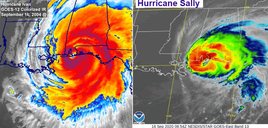
Today is a doubly punishing date in hurricane history for the east-central Gulf Coast, marking the 18th anniversary the landfall of Category 3 Hurricane Ivan and the 2nd anniversary of Category 2 Hurricane Sally, both of which struck near Gulf Shores, AL, causing major damage in coastal Alabama and the western Panhandle.

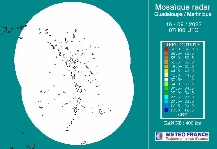
Active Storms: Tropical Storm Fiona is approaching the northern Lesser Antilles this afternoon, still sporting maximum sustained winds of about 50 mph, mostly north and east of the center. As seen on radar, Fiona’s low-level center remains well west of its deep convection due to westerly shear, which means little strengthening in the short term as Fiona moves west at around 15 mph for the next 36 hours or so.

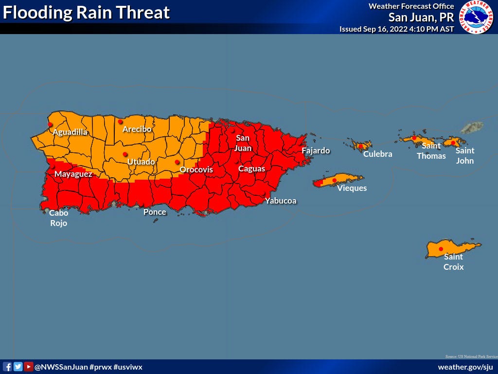
On this track, Fiona will pass just south of Puerto Rico between late Saturday and mid-day Sunday as a tropical storm. The overall forecast prognosis for the Virgin Islands, Puerto Rico, or Hispaniola has not changed much since yesterday; coastal areas in this region will likely see low-end tropical-storm-force wind gusts for 12-18 hours after the center of circulation passes. Heavy rainfall and flash flooding remains the primary threat, with 4-8” or more of rainfall expected, particularly in southern and eastern Puerto Rico.
After Fiona clears Puerto Rico on Sunday, it is likely to slow down, at which point it may begin to intensify once clear of land influences. Should this strengthening occur, it is increasingly likely that a weakness in subtropical ridging will be sufficiently strong to lift Fiona north well to the east of the U.S. East Coast by the end of next week. Global models are in better agreement today on preventing a ridge of high pressure over the U.S. Southern Plains from extending eastward next week, and thus the guidance consensus shown below has shifted north and east since yesterday. Under this scenario, Fiona would likely to continue to strengthen as it accelerates northeast, but would not be a land threat other than to Bermuda.
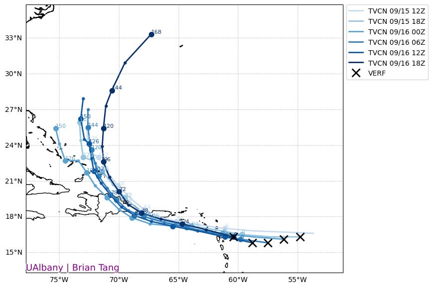
Alternately, there is still the possibility that Fiona either does not survive its transit of the Greater Antilles, like TS Erika in 2015, or remains weak and moves more slowly as it clears the islands. A few ensemble members, primarily from the 12z Euro run at left, show a weaker Fiona drifting west-northwest in 5-7 days; another small cluster moves Fiona north for a few days before the trough leaves it behind late next week, with a subsequent drift over the western Atlantic. The 12z GFS Ensemble members at right are almost all showing a faster and stronger track out to sea, though the GFS has been biased north and too strong for most of the last few days with Fiona.
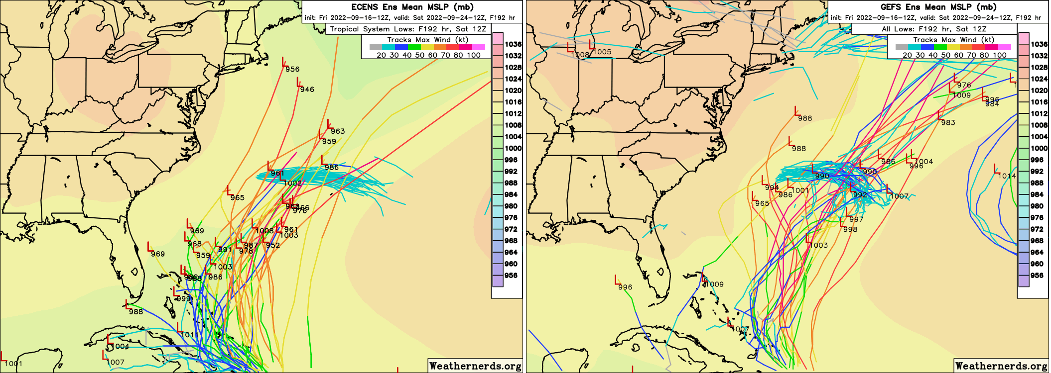
Overall, the steering pattern evolution since yesterday is good news, as the window for Fiona to hitch a ride out-to-sea is definitively wider than it was 24 hours ago, and that remains the most likely individual scenario by far. However, given the uncertainty in where and how strong Fiona will be in 3-4 days, the possibility of something else happening still can’t be ruled out. We’re trending in the right direction with Fiona, but not quite totally clear of a Florida or U.S. East Coast threat just yet.

Other Disturbances in NHC outlook, with 2-/5-day NHC development odds:
West of Bermuda (10/10%): A frontal low is moving east across the western subtropical Atlantic, as expected. This is not likely to acquire tropical characteristics before dissipating.
Tropical Atlantic (0/20%): A wave in the eastern MDR has a slight chance of development early next week as it moves into the mid-latitudes. No concern.
Elsewhere: Nothing else of note. Have a great weekend.
Next report: Daily update out Monday afternoon.