


Atmospheric Ignition (Remix): The Hurricane Watch for September 8th
Hurricane Lee reached Category 5 intensity yesterday, and will remain a powerful hurricane as it passes well east of Florida. The Northeast U.S. should watch closely.
Enjoy this sample of WeatherTiger’s daily tropical bulletins, just one of the benefits of being a paid supporter of the Hurricane Watch. Sign up here to receive these forecasts each weekday.
This post is outdated! Click below for WeatherTiger’s Tuesday update on Lee.

Florida tropical threat synopsis: No direct tropical threats to Florida over the next 10 days. Hurricane Lee will cause high seas and beach erosion on the Atlantic coast next week, as the storm itself tracks over 500 miles east of the state.
Mood music:
Almanac: It’s Friday, September 8th… day 99 of the 2023 hurricane season, 84 days to go. By total storm energy, the season is 41.4%, 53.1%, and 42.0% complete for the Atlantic, continental U.S., and Florida, respectively.
With the Atlantic on fire heading through the peak week of hurricane season, WeatherTiger’s real-time seasonal outlook model has shifted quite a bit recently. With over 65 ACE units on the books so far and another 40 ACE just in the NHC forecasts for Lee and Margot in the next 5 days, our seasonal ACE expectations have risen to around 170. This is a roughly two-thirds chance of a hyperactive (>165 ACE) season, up from about a 25% chance in July.
Active Storms:
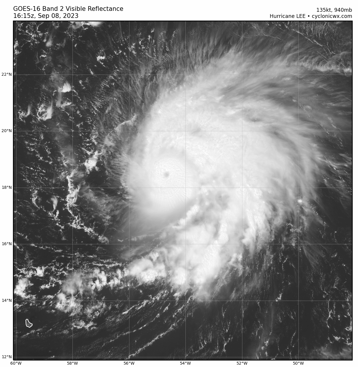
Hurricane Lee underwent head-spinning rapid intensification last night, bottoming out at Category 5 intensity in the early morning hours with top sustained winds of 165 mph. Since then, Lee has weakened a touch in response to some shear out of the southwest, with pressure rising about 15 millibars and sustained winds now in the high-end Category 4 range. Note that the leading edge of Lee’s cloud shield is distinctly flat on the western half of the storm; intensification is unlikely until outflow improves to the west.

This shear may ease tomorrow, and Lee could make another run at Category 5 strength over the weekend or early next week as it continues west-northwest on a path 300-400 miles north of the Lesser Antilles and Puerto Rico. The islands will only be affected by occasional showers and extremely high seas as Lee passes to the north, likely continuing at Category 4-5 strength through Tuesday or Wednesday. There is no change to the 5-day forecast since yesterday.
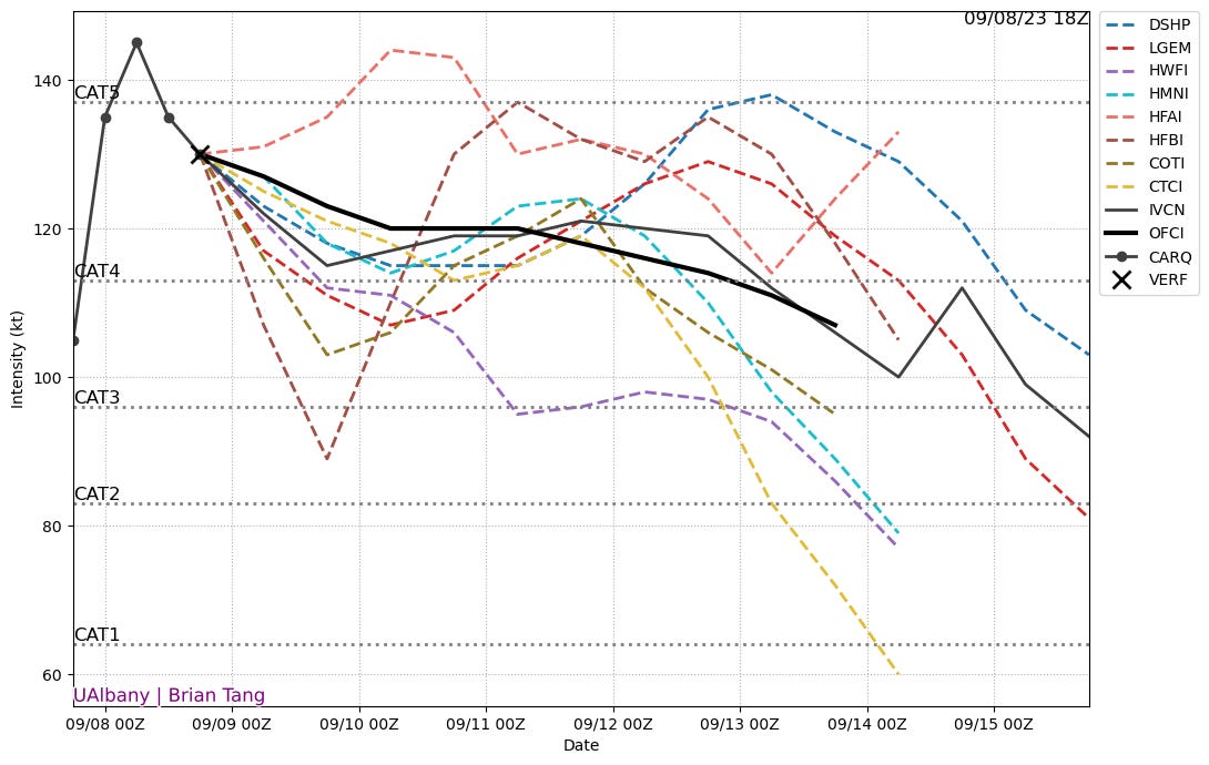
Intensity models show another ~4 days of Category 4 or 5 fluctuations. Lee is moving at 10-15 mph to the WNW today and this general motion will continue into early next week, with forward speed slowing Monday and Tuesday. By Wednesday, Lee will turn north, likely along or near 70W longitude, in response to a trough of low pressure over the eastern third of the United States. This part of the forecast is high confidence, and Lee poses no risk to Florida other than high seas of 6-10' and beach erosion along the Atlantic coast by mid-week and continuing into next weekend.
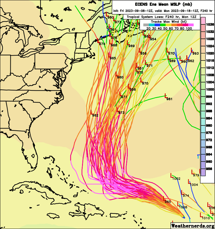
A turn north along 70W, roughly the longitude of Cape Cod, does leave the door open for potential impacts on New England if Lee's track on days 6 to 9 remains more northward than northeastward. Eastern New England is in the western third of the ensemble tracks envelope on days 8-10, as models continue to struggle with where western Atlantic ridging will set up and how quickly the eastern U.S. troughing will depart.

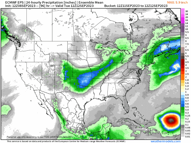
12z Euro Ensemble tracks for Lee over the next 10 days. Overall, Lee remains a feature to watch closely for potential rain and wind impacts on the northeast U.S. next weekend, particularly in eastern New England, as well as in Atlantic Canada. While Lee will cross Franklin and Idalia’s cooler wake in about a week and should no longer be a Category 3 or 4 as it moves north, it will be a large and powerful hurricane and impacts may extend far from the circulation center in all directions, as shown on the 12z Euro ensembles precipitation maps below.
Tropical Storm Margot is a minimal tropical storm in the far eastern Atlantic, badly sheared today. Assuming Margot can hang on over the next 48 hours, most models indicate an improving environment and potential for strengthening to a hurricane as it rolls northwest into open ocean. Margot is no threat to any land.


Other disturbances in NHC outlook, with 2-/7-day NHC development odds: None.
Elsewhere: No other features of note in the Atlantic today. There continues to be some model support for another tropical wave developing in the eastern or central Tropical Atlantic in 5-10 days, though there are no specific indications that this wave is particularly alarming. Always worth watching this time of year, however.
Supporters, check out the latest odds of additional U.S. hurricane landfalls over the paywall below.
Next report: Daily bulletin out Monday morning for subscribers, weekly column out Tuesday afternoon for all.
Updated U.S. Landfall Model (Supporters only)
Keep reading with a 7-day free trial
Subscribe to WeatherTiger's Hurricane Watch to keep reading this post and get 7 days of free access to the full post archives.