


WeatherTiger's Tropical Storm Elsa Analysis for July 5th
Elsa crosses Cuba, with potential for some strengthening in the Gulf increasing.

WeatherTiger’s Hurricane Watch will be issuing daily (or more) forecasts for Elsa for the duration of the threat to Florida. If you enjoy our work and are not already a supporter, please considering signing up for our paid subscription service to receive a daily threat briefing each weekday, or sharing this blog with your friends and family.

Tropical Storm Elsa is poised to enter the southeastern Gulf of Mexico, and widespread heavy rainfall will advance up the Florida peninsula through Tuesday. A continued incremental shift west in its expected track likely will focus the worst impacts of the storm on west central Florida and the eastern Big Bend, though uncertainty in the extent of rain, wind, and surge remains in the forecast.
As of the National Hurricane Center’s 2 p.m. Monday advisory, Tropical Storm Elsa is located inland over west-central Cuba, with maximum sustained winds of 60 mph. Elsa is moving northwest at around 15 mph, and will pass near Havana and into the Gulf overnight followed by a turn north off the Southwest Florida coast on Tuesday.
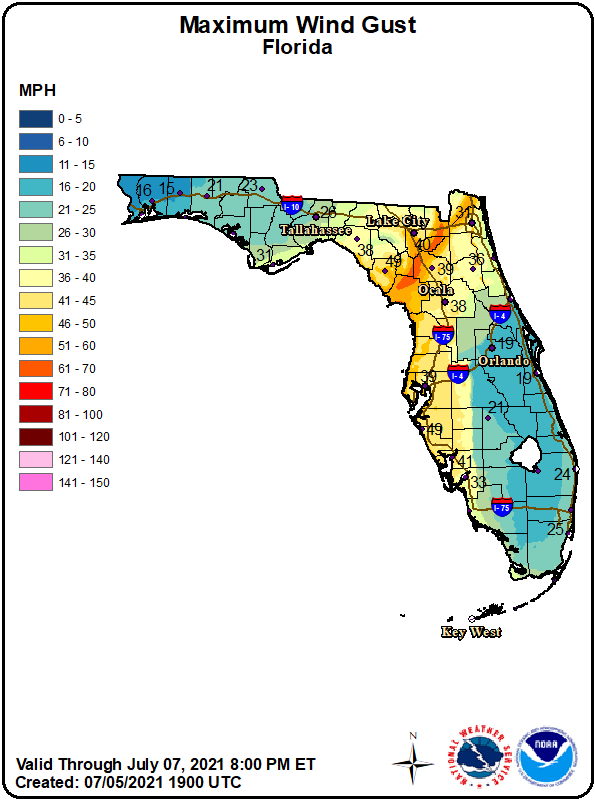
As has been the case through the weekend, there is little inclement weather in the western half of Elsa’s circulation as it negotiates Cuba, while storms extend for several hundred miles north and east of the center. With squalls overspreading southern Florida and coastal winds gusting over 40 mph expected to continue well east of the center, the Keys and entire peninsular Gulf Coast are under a Tropical Storm Warning. The eastern half of the Panhandle is under a Tropical Storm Watch.
Much of the Gulf Coast, including Tampa Bay and Apalachee Bay, are also under a Storm Surge Watch, indicating the potential for two to four feet, or more, of surge. These watches may well be increased to warnings on Tuesday—as always, refer to your local National Weather Service forecast office and the National Hurricane Center for the latest information.

The general contours of Elsa’s forecast track have not changed in the last 24 hours, with a path paralleling Florida’s west coast offshore on Tuesday and acceleration north-northeast to landfall on Wednesday remaining the NHC official forecast as well as model consensus. However, Elsa tracked slightly further west than expected over the weekend, so the most likely course of the center is now in the general direction of eastern Apalachee Bay and the Big Bend.
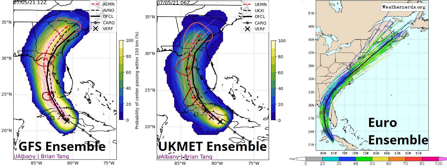
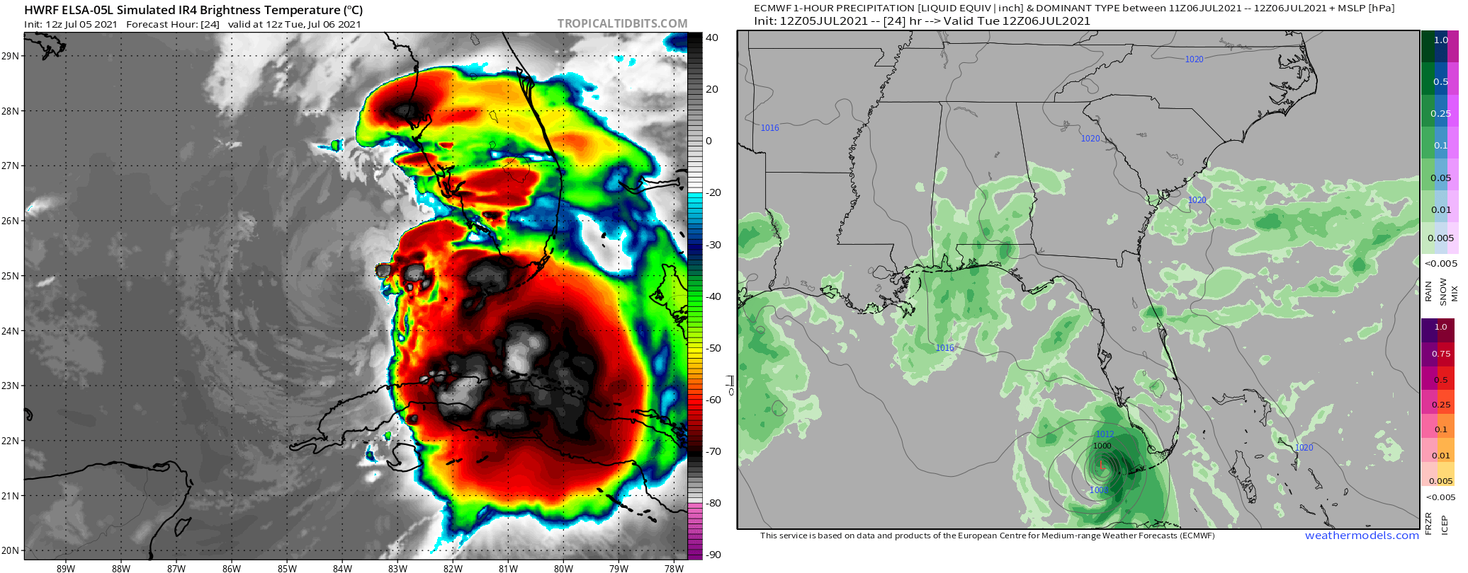
This gives Elsa about 36 hours in the Gulf to restrengthen, from midnight Tuesday to noonish Wednesday. As its path across Cuba is one of the flatter and swampier ones possible and radar and satellite data indicate that the disorganized tilt of Elsa’s vortex may have diminished a bit as of Monday afternoon, there is a little more upside intensity potential in the current forecast versus yesterday’s.
Elsa will emerge into the Gulf as a mid-range tropical storm, but Monday’s model guidance is somewhat divergent on how much the storm will restrengthen. During its time over water, Elsa will be experiencing 15 to 20 knots of wind shear from the west, which can be highly detrimental when bringing dry air into the core of storm, or manageable when the imported airmass is more humid. Dry mid-level air is lurking to Elsa’s west, but models disagree on whether or not this airmass will be able to punch through to Elsa’s center on Tuesday.
Basically, the models that show a dry air influx keep Elsa as a tropical storm through landfall; a minority of models are a weaker with the shear-dry air combination, and suggest a possible strengthening to Category 1 hurricane status. Digging into the nuts and bolts of the guidance, this stronger outcome will be more likely if deep convection remains near or over the center of circulation through mid-day Tuesday. A partially exposed low-level circulation Tuesday morning would indicate the weaker scenario is most likely.
Whether Elsa reclaims hurricane status or not, significant impacts for much of Florida are unavoidable. The most widespread impact of Elsa will be rainfall, with 3-5” likely over the life of the storm from Southwest Florida into North Central Florida, including the eastern Big Bend. Totals over the eastern peninsula will be more on the order of 1-3”, mostly falling on Tuesday and early Wednesday. For the Panhandle, the fact the eastern half of Elsa will be much wetter than the western half means a relatively sharp gradient in rain totals will probably slice through the central Panhandle or western Big Bend, even with a track into Apalachee Bay. There should be a better read on where this dividing line may land tomorrow.

Wind and surge impacts are also certain along the immediate Gulf coast, even if Elsa does not strengthen. A southerly fetch of offshore tropical storm force winds will cause dangerous coastal flooding in south-facing sections of coast, including eastern Apalachee Bay and possibly low-lying sections of Tampa Bay. Surge inundation is always a threat to life and property, so coastal residents should carefully monitor local emergency management information sources. While widespread, severe wind damage is not expected, tropical storm force winds along the Gulf Coast and potentially inland over north Florida could certainly cause tree damage and some power outages.
Finally, landfalling tropical cyclones very commonly produce tornadoes east of their track, and Elsa will likely do the same. Everyone in the peninsula and eastern Panhandle should have a way of receiving Tornado Warnings through the passage of Elsa to mitigate this risk.
Overall, Florida has certainly faced worse than Elsa, but the storm has the potential to be an underestimated threat, especially along the west central Florida and Big Bend coasts. I’ll be back on Tuesday, providing updates on the latest changes to Florida’s forecast. Keep watching the skies.
Next update: A written forecast analysis will be issued around 4 p.m. tomorrow. I also plan on issuing a forecast video mid-day tomorrow, time TBD. This will be broadcast on our Facebook page live and subsequently reposted here.