WeatherTiger's Potential Tropical Cyclone Nine Forecast for September 23rd
PTC 9, future Helene, is a major hurricane landfall threat to the Florida Gulf Coast.
This post is outdated! Please read the updated forecast by clicking below:
WeatherTiger’s Hurricane Watch is a reader-supported publication. Paid subscribers get daily tropical bulletins, weekly columns, coverage of every hurricane threat, the ability to comment on posts and ask questions, & more. Paid supporters will also receive a subscriber-exclusive morning forecast briefing through the threat from PTC 9/Helene starting tomorrow.
It’s happening again.
Potential Tropical Cyclone Nine, soon-to-be Helene, is likely to become yet another Florida Gulf Coast hurricane landfall within a matter of days. While there remains uncertainty in the track and intensity forecast, Florida isn’t getting out of this one.
More damaging and less damaging outcomes are possible, but know that the Panhandle, Big Bend, and west-central Florida coasts are at serious risk of surge, wind, and rain impacts from a potential major hurricane landfall Thursday or Friday, and impacts will extend far inland across North Florida and South Georgia. Preps to secure life and property should start now in these areas. Consider this your fire alarm.
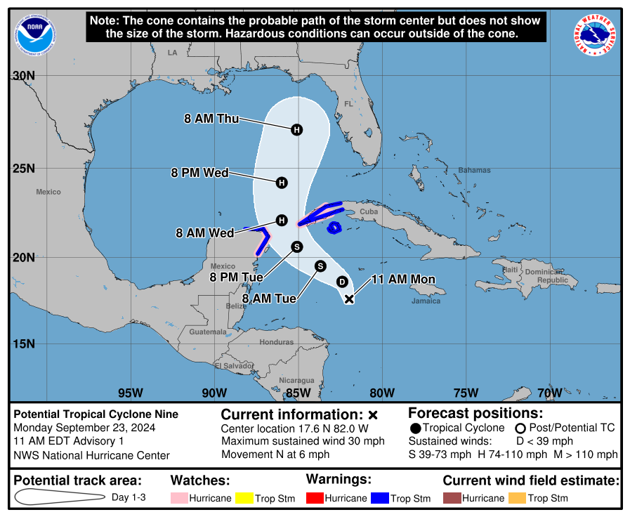
As of mid-day Monday, the National Hurricane Center has begun issuing advisories on Potential Tropical Cyclone Nine, located just south of the Cayman Islands in the western Caribbean Sea. For now, this system is a “potential tropical cyclone” rather than tropical depression or storm because it does not yet have a well-organized surface circulation, but that could happen at any point. Hurricane Watches are in effect for the northwestern Caribbean, and will likely be required for portions of Florida on Tuesday and Wednesday.
With the potential storm still consolidating and entangled for another day with a broad Central American Gyre, a movement to the west-northwest is expected through Tuesday, followed by a turn north through the Yucatan Channel on Wednesday morning, by which point future Helene should be at or nearing hurricane intensity as it enters the southern Gulf of Mexico.
Several key developments over the weekend have winnowed away some of the less threatening possibilities for how Helene plays out, and increased the severity of the Florida threat. The storm has organized on the quicker side of the possibilities, giving it more time to organize and strengthen prior to landfall. The system’s circulation is also coming together fully over water and should shoot the gap between the Yucatan peninsula and western Cuba, so land interaction is not going to tap the brakes either.
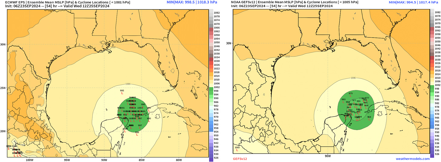
Instead, future Helene has about three and a half days to develop a core of deep convection and take advantage of a favorable thermodynamic and atmospheric environment for strengthening, which sets it up for potential rapid intensification on approach to Florida. While Helene reaching major hurricane intensity is not certain, as with Michael, Ian and Idalia before it, the warning signals are there.
Here’s the first roadmap to track and intensity expectations.
Track forecast: Following a channel
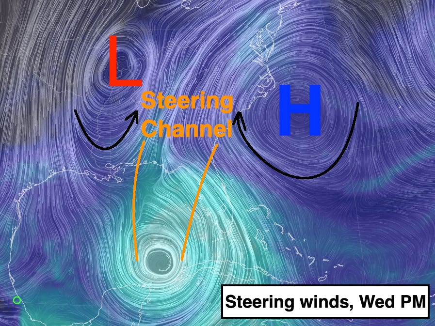
Helene’s track across the Gulf will follow south-to-north steering winds between high pressure aloft currently over Florida that will shift east into the western Atlantic, and an upper-level cutoff low moving into the Lower Mississippi Valley by Thursday. The storm will accelerate north or north-northeast as it embeds in this steering wind channel on Wednesday and Thursday, which will bring it to the Florida Gulf Coast no later than early Friday. Models are trending stronger with the offshore ridging, which should keep Helene moving north-northeast and prevent an Ian-like sharper hook to the northeast across the Florida peninsula from occurring this time.
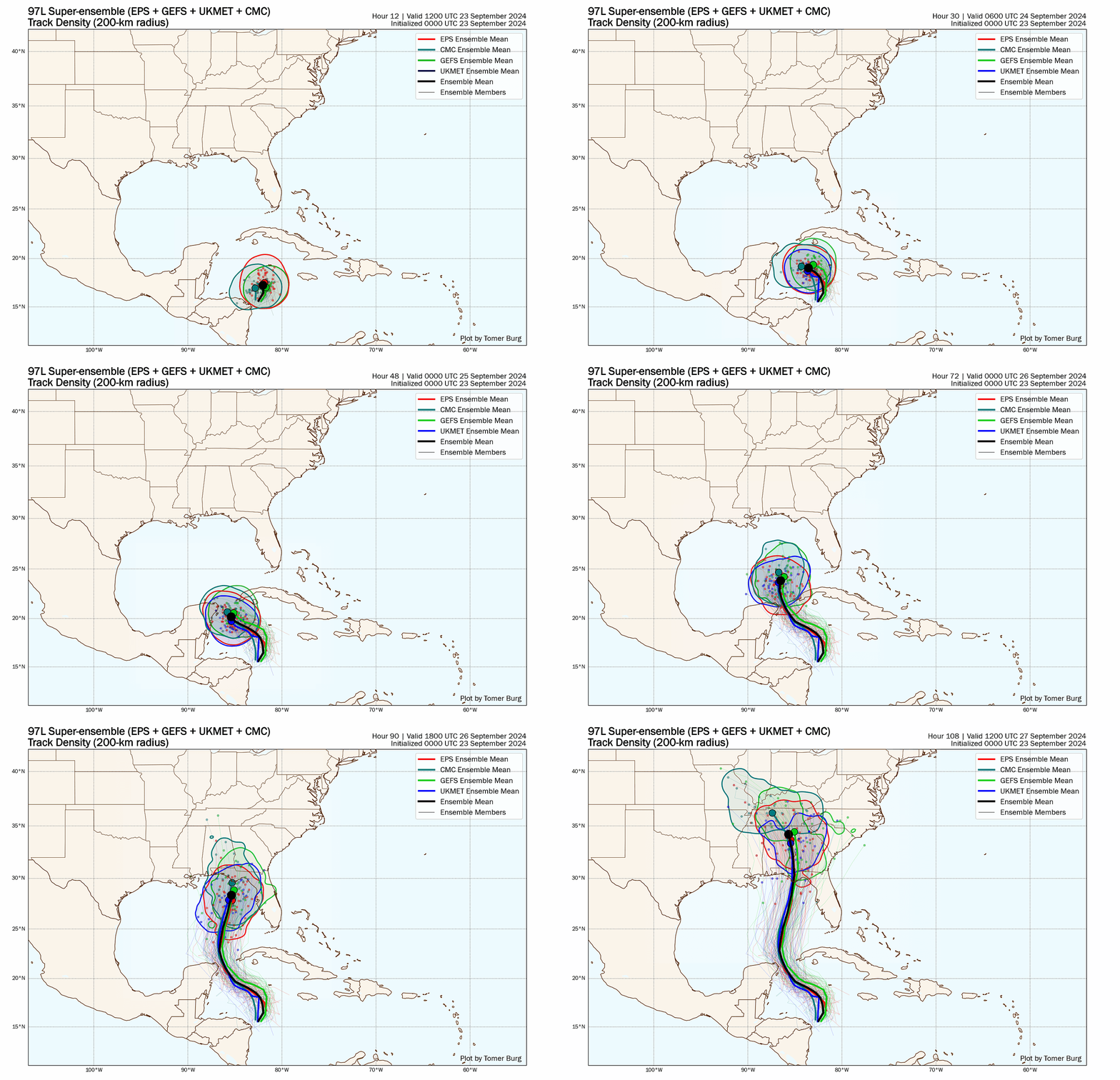
The potential storm does not yet have a clear, well-organized center of circulation, so we still don’t know exactly where Helene will drop into that steering channel. If its center consolidates within the western part of that broad area of turning, the western or central Panhandle would be at higher risk of landfall; if it’s a bit further east, that would shift the most likely track into the eastern Panhandle, Big Bend, or Nature Coast. With the developing system still messy, it’s too early to put a fine point on precisely where landfall will occur, but a general range between Tampa and Destin is most probable at this time. Likely landfall timing is Thursday afternoon or evening.
So: details TBD, but I am confident that Helene is coming to the Florida Gulf Coast. Note that this is likely to be a larger-than-average hurricane, so while a landfall in Southwest Florida is not expected, wind, rain, and surge impacts are still expected there as well as throughout the eastern Gulf Coast as a whole.
Intensity Forecast: A rapid intensification threat
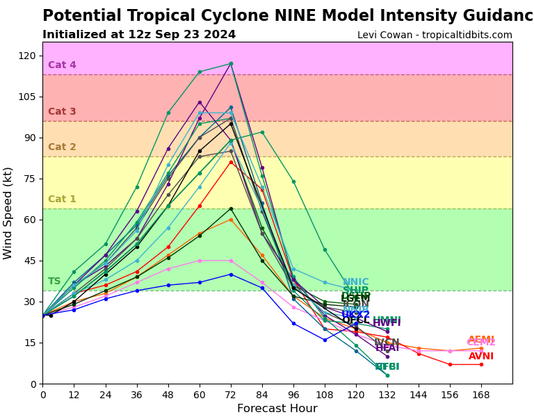
The real uncertainty lies in the intensity forecast. Many aspects of the oceanic and atmospheric environment Helene will be working with on Wednesday and Thursday bring to mind conditions preceding Michael, Ian, and Idalia, which means a landfall intensity of Category 3 or above is a strong possibility, as suggested by the initial NHC forecast. Remember also that categories are defined only by maximum sustained winds, not by size, surge, or rainfall, so “category” in this case will underestimate the extent and severity of human impacts.

There are two big questions regarding how strong Helene will get. The first: how quickly does it wrap up over the next couple of days in the Caribbean? With the circulation remaining broad and disorganized today, models are split on whether it takes until Tuesday or Wednesday for a core to manifest. If Helene is already a hurricane as it enters the Gulf Wednesday morning, it’s more likely to reach Category 3 or 4 strength crossing the eastern Gulf. Unfortunately, Helene is poised to track over a warm ring of the Loop Current mid-to-late Wednesday, where the Gulf waters are as hot and deep as they have ever been. Upper-level outflow is also expected to be close to ideal at that time. Rapid intensification from Wednesday into early Thursday may steep, as signaled by our best hurricane models.
The second question comes down to whether the interaction between the upper low over the Mississippi Valley and the hurricane will be favorable or unfavorable on Thursday. This is a tough question. If the strong upper-level winds associated with the cutoff low are a little farther away from the storm, that can act to enhance outflow and strengthen or sustain a storm into landfall, as with Michael; if they are a little closer, stronger shearing winds over the hurricane might cap or weaken it into landfall, as happened in Idalia’s final hours over water. Strong enough, and that shear might even keep rapid intensification from happening at all on Wednesday, in which case a Category 1 or 2 storm would be a possibility. Those details are beyond what can be predicted now with anything other than foolish confidence, with good models on both sides of the fence. In general, we want to see a slower consolidation of Helene’s circulation in the next day or so, and a closer approach of the upper low midweek to keep the lid on intensification. We shall see.

I know the Michael comparison is in mind, and with cause. The NHC forecast track and many of the individual model solutions floating around have scary parallels to Michael, and the central Gulf waters are even warmer and deeper than what it crossed six years ago. However, Michael was the meteorological equivalent of rolling snake eyes or flipping tails five or six consecutive times. I won’t say that isn’t a possibility here, but everything would have to go exactly wrong.
Of course, Helene doesn’t have to be literally Michael to have broad and severe impacts consistent with a major hurricane, and—stop me if you’ve heard this one—that is what the Florida Gulf Coast is probably going to get on Thursday. Time to prepare is short, with inclement weather likely arriving along the Gulf Coast as early as Wednesday afternoon. The storm will spread surge impacts across the Florida Gulf Coast even under less bad outcomes, including well south and east of the most probable landfall region. This includes Tampa Bay, where surge with Helene is a serious, serious concern, even if it goes well to the west. Be prepared to evacuate if recommended to do so.
I’ll have much more tomorrow on the expected surge, wind, and rain impacts, but you need to start preparing in the Panhandle, north-central Florida, and west-central Florida. Helene will come at you faster than you think, so go into hurricane mode now. I hate to pull the fire alarm for the Gulf Coast yet again, but what I’m seeing warrants it. I’m hoping I’m wrong harder than anyone, but in case not, get ready and keep watching the skies.
Next update: Forecast briefing for paid supporters out early tomorrow morning. Schedule is uncertain for the afternoon forecast for all subscribers tomorrow due to a medical procedure, but I will have a written or video forecast at some point for all in the afternoon or evening.




Thank you, sir. Hope all goes well tomorrow. We send our best wishes!
Thank you, as always, for preparing us.