WeatherTiger's 2021 Hurricane Season Year-in-Review
Wrapping up another calamitous season for the Gulf Coast.
This is the last of 124 updates WeatherTiger subscribers have received during the 2021 hurricane season. We hope our forecasts helped you better prepare for 2021’s many threats.
We’re celebrating the end of the 2021 season, and its 21 storms, with a 21% off sale. Lock in daily briefings, in-depth forecasts, videos, live landfall coverage, seasonal outlooks, and the ability to comment and ask questions for the entire 2022 hurricane season for our lowest-ever price of just $39.50/year. That's a 21% savings off our annual subscription price of $50.
Our 21 storms, 21% off deal is a limited-time offer, so sign up now and receive a special paid-subscribers only look ahead to the 2022 season in December. Feel free to get in touch at ryan@weathertiger.com with any questions, and enjoy our 2021 year-in-review below.
Eternal return is the idea that all events throughout time and space recur in an infinite loop.
Some readers may dimly recall I also began this June’s pre-hurricane season outlook that way. However, it wasn’t just brain-fogged meteorologists having trouble generating original content this year; in many ways, 2021 mimicked the slings and arrows of an outrageous 2020, tropically and elsewhere. Fortunately, very much unlike 2020, but like most of us beleaguered humans, hurricane season 2021 ran out of steam around late September.
While tropical activity can occur after the official end of the season, no U.S. landfalls have ever occurred after December 1st and there is nothing on the horizon. Thus, it’s time for WeatherTiger’s look back on the 2021 hurricane season, which again brought misery to the Gulf Coast, this time while Jeff Bezos took short, pointless trips to space.
May
While Brood DMX emerged from a 17-year slumber with a moment of silence for its fallen namesake, the Atlantic was buzzing prior to the June 1 start of hurricane season for a 7th consecutive year. Tropical Storm Ana’s meanderings east of Bermuda were of no impact, but did set a brisk pace heading into June.
June
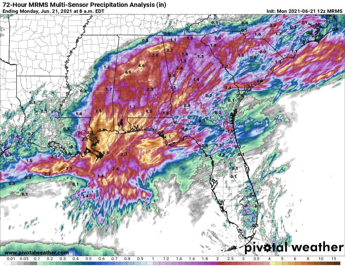
Louisiana again went on the board early in the season, just over 7.5 months after the last of 2020’s onslaught. Tropical Storm Bill skirted the Outer Banks mid-month, followed by Tropical Storm Claudette slogging ashore south of New Orleans on the 18th with gale-force wind gusts and rain totals of 5-15” (see above) for the east-central Gulf Coast. Quick-hitting Danny piped into Charleston on the 28th as a weak tropical storm with minimal impacts.
July
Early July brought the first semi-serious tropical threat of the year in the form of Elsa, which peaked as a Category 1 (above) on the Saffir-Simpson Hurricane Wind Scale but a Category 5 on the “Frozen” memes index. Elsa was the quickest fifth storm to develop, beating 2020’s record, and was also one of the earliest-ever formations in the Tropical Atlantic east of the Lesser Antilles.
After feinting at EPCOT, Elsa crossed Cuba and angled for the Big Bend, making landfall in where-else-but Steinhatchee, FL as a 65-mph tropical storm on the 7th. Localized wind and surge damage occurred along the west-central Florida coast, as well as in the Northeast as Elsa raced up the U.S. East Coast as a tropical storm.
The Atlantic was otherwise quiet as the country sweltered under the cruel tutelage of a massive “heat dome,” the only natural predator of the polar vortex.
August
Much as Fred Durst inexplicably re-emerged in August with the mien and facial hair of a community college comp lit adjunct, the peak of hurricane season was packed with tough-to-predict swings in storm tracks and intensity. Fred got things rollin’ with a mid-month strike near Port St. Joe, spreading tropical storm winds over a swath of the central Panhandle and causing serious flooding near Panama City and in western North Carolina. Fred’s track closely followed that of Hurricane Michael, though its maximum sustained winds were thankfully around 100 mph lower. Nevertheless, gusts clocked a formidable 73 mph on Saint George Island.
Hurricane Grace initially followed Fred’s footsteps through the Caribbean, then continued west and became 2021’s first major hurricane while making landfall in the Mexican state of Veracruz. Grace was eclipsed in the public eye by Henri, an unusual Category 1 that threatened New England with its first direct hurricane landfall in almost 30 years. Henri weakened to a 60-mph tropical storm prior to striking just west of Rhode Island’s legendary Nordic Lodge on the 22nd and caused localized flooding in the northern mid-Atlantic.
As in 2020, by far the worst of the 2021 season came to Louisiana in late August, this time in the form of Hurricane Ida (above). In little more than three days, Ida surged from a tropical depression in the western Caribbean to a high-end Category 4 (?) hurricane knifing across eastern Louisiana, bringing devastating surge to an already-battered coast and cataclysmic inland wind damage, including to western portions of the New Orleans metro area.
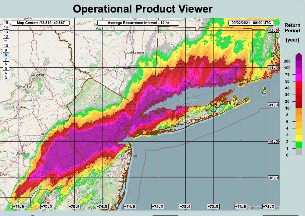
Ida then continued northeast and caused 1-in-100-year or worse flooding in southern New York and northern New Jersey, including rainfall of up 10” in mere hours (above). The NHC jury is still out on exactly how strong it was, but Ida’s combination of terrifying rapid intensification and extreme rainfall impacts makes it one of the top 10 worst U.S. hurricanes of all-time. Elsewhere, Julian and Kate were anonymous mid-ocean tropical storms that blipped in and out of existence as Ida threatened.
September
September’s tropical activity focused its considerable rage away from populated landmasses. The month’s headliners were Major Hurricanes Larry and Sam, which combined for over 60% of 2021’s total accumulated cyclone energy (ACE) as they swooped from the Cape Verde region into the North Atlantic to respectively open and close September. On the other hand, Tropical Storms Odette, Peter, Rose, Teresa, and Victor were weak, short-lived storms that together account for less than 5% of seasonal ACE.
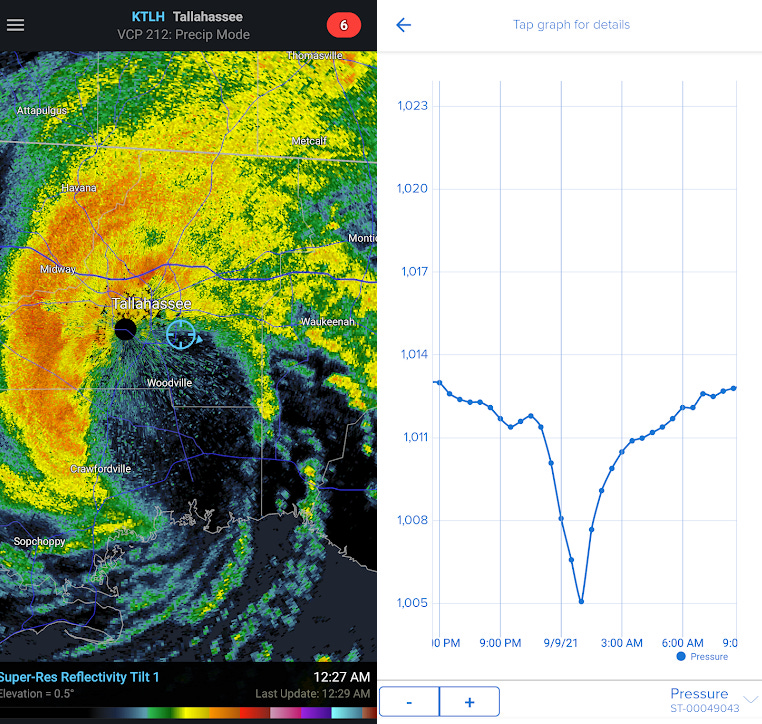
U.S. impacts, such as they were, remained focused on the Gulf Coast. Tropical Storm Mindy developed as it came ashore near Apalachicola but punched above its feather weight, with gusts pushing 60 mph in western Apalachee Bay. Mindy was also first since 2004 to track directly across Leon County, with WeatherTiger World HQ landing in what was arguably the rudimentary eye-like structure of a minimal tropical storm (see above). Odd stuff.
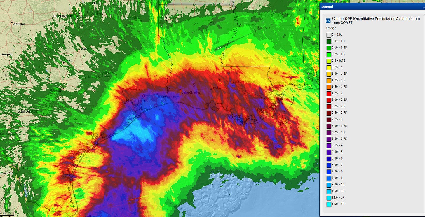
On the other side of the Gulf, Hurricane Nicholas cagily peaked as a minimal Category 1 just minutes prior to landfall in central Texas on the 14th. Nicholas chewed the scenery for several days before dissipating, spreading 5-10” or more of unwanted rainfall across coastal Texas and southern Louisiana and triggering additional flooding in areas still reeling from Ida (below).
October
Like Amazon Prime, the Tropical Atlantic slowed down deliveries dramatically in October. After Sam and Victor spun out over the open Atlantic early in the month, elevated wind shear in the Caribbean and western Atlantic kinked the tropical supply chain, finally diverging from a hyperactive October 2020. Wanda, developing on Halloween east of Bermuda, was the only Atlantic storm formation of the month.
November
Unlike last year’s bizarre profusion of late-season activity, November 2021 brought nothing more than Wanda’s continued wanderings of the open Atlantic. This left plenty of time for repeat listens to “All Too Well (15-Hour Version)1,” a lyrical defenestration of Jake Gyllenhaal in which Taylor Swift dissects every scientific inaccuracy in “The Day After Tomorrow.”
Final Thoughts
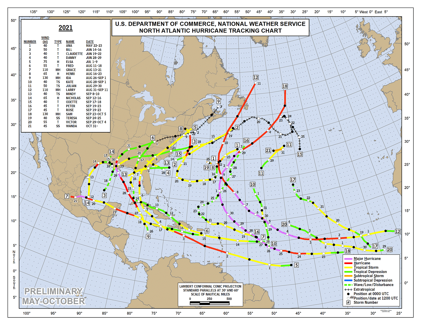
History doesn’t repeat, but it does rhyme. This year’s 21 named storms are the third-most since 1851, though well off 2020’s record mark of 30. Hurricane (7) and major hurricane (4) counts in 2021 were within more typical ranges for an active season.
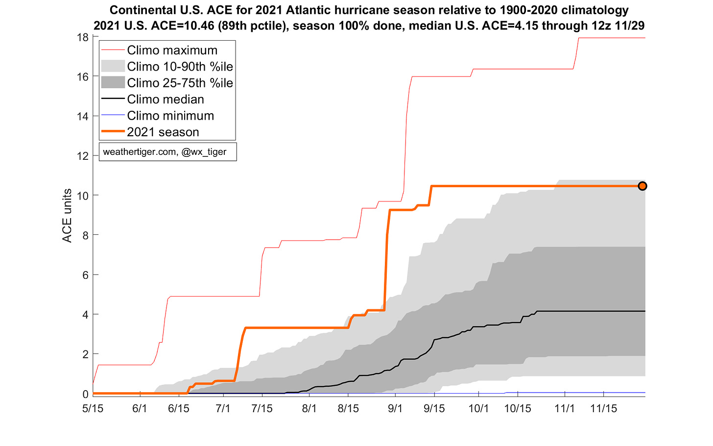
This year remained unusually efficient in translating that activity into repeated hits, especially for the Gulf Coast. 2021’s total ACE of 145 is greater than about 3 of every 4 years since 1950, though this is the sixth-consecutive year of above-average activity. However, this frequency of U.S. landfalls (10.5 ACE units, 8 tropical storms, 2 hurricanes) is expected roughly every 10 years. For the Gulf Coast, that return period is once per 15 years, following a roughly 1-in-30 year surfeit of landfalls in 2020.
While 2021 pulled a few more punches than 2020, the tape shows that this hurricane season was again quantitatively excessive and qualitatively preposterous, like the simultaneous existence of two Shiba Inu-themed cryptocurrencies. Ida’s Category 4 landfall was close to a worst-case scenario for eastern Louisiana, and the combined impacts of Elsa, Henri, and Ida added up to some of the worst flooding ever recorded in the Northeast U.S. On the other hand, the three-pack of tropical storm landfalls huddled into the eastern Panhandle qualifies as only light punishment for Florida, and the Florida East Coast’s miraculous lucky streak survives another year.
Overall, I don’t think I’m telling any tales out of school to say that the operative sentiment of 2021, hurricane-wise and otherwise, is fatigue. We’re tired of Mark McGrath reminding us to wash our hands from gas pump TVs, tired of the absurd notion that anyone would voluntarily enter any -verse created by Mark Zuckerberg, and tired of trudging the Möbius strip of wild weather and hurricane threats.
To this, I can only offer the short-term certainty of around five-and-a-half months without tropical concerns, and the longer-term hope that next spring’s El Nino potential might keep the 2022 season in relative check. The future is unwritten, but here’s hoping for fewer masks littering the ground and fewer hurricanes to watch when the endless cycle starts again.
Take care of each other, Weather Fans, and until next year, keep watching the skies.
A.k.a. the Millennial “Freebird.” Think about it.





Thank you Dr. Truchelut for another season of service. We greatly appreciate your insight and expertise. Hope you and the family have a wonderful holidays. See ya next season! 🙂