WeatherTiger Tropical Storm Fred Impacts Forecast for August 15th
Fred's ability to break stuff will be limited, but North Florida can expect rain and coastal winds.
WeatherTiger’s Hurricane Watch will be issuing daily forecasts for Fred for the duration of the threat to Florida. If you enjoy our work and are not already a supporter, please consider signing up for our paid subscription service to receive a daily threat briefing each weekday, or sharing this blog with your friends and family.
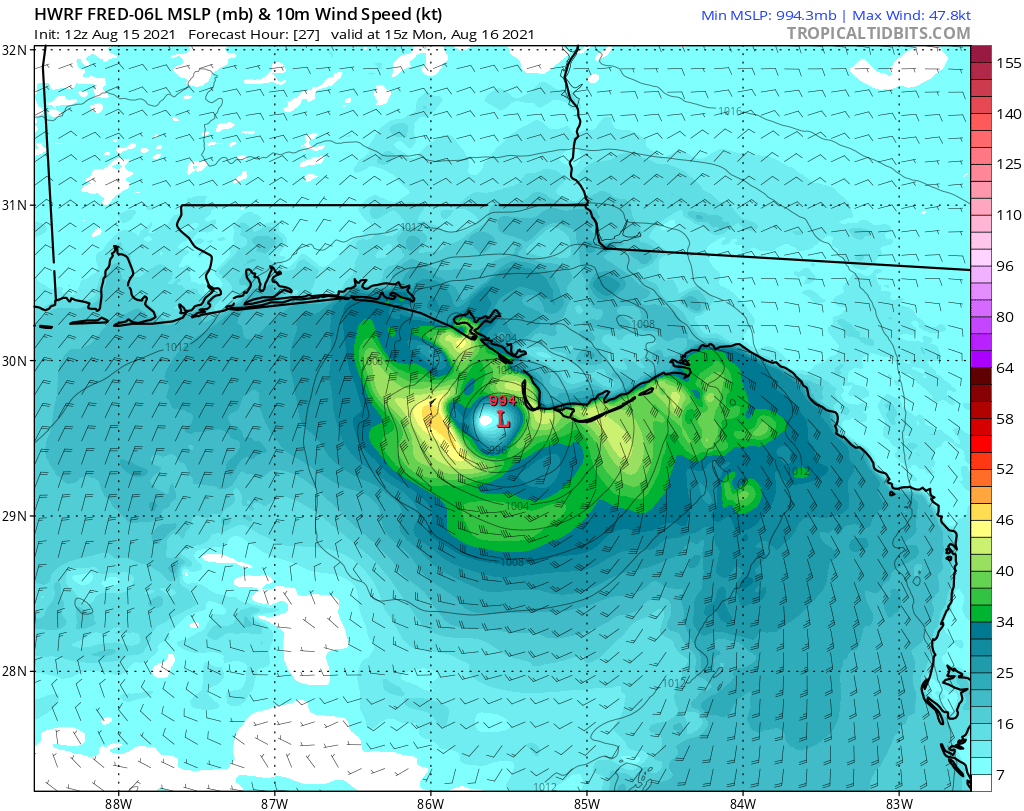
A rebooted Fred is inbound to North Florida after regaining tropical storm strength Sunday. Fred’s general path through a Monday landfall has shifted back in the general direction of the central Panhandle, with the key impacts remaining intermittent heavy rainfall and gusty winds in squalls beginning in the overnight hours ending late Monday.
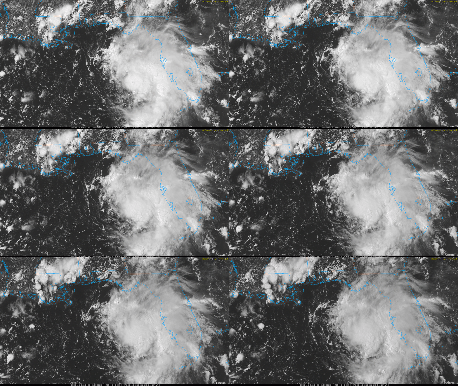
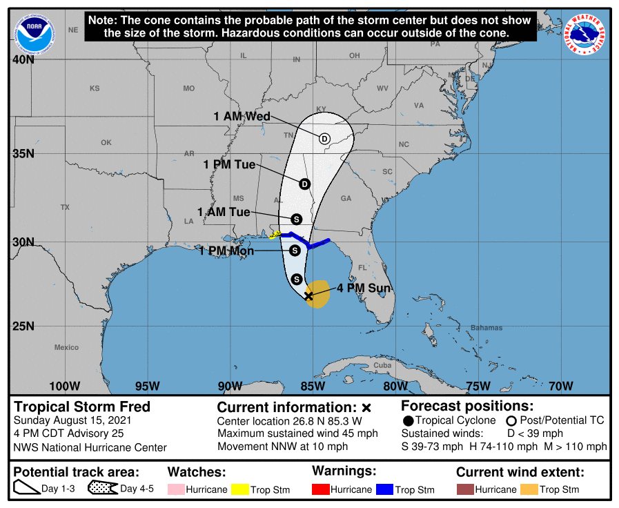
The National Hurricane Center’s 5 p.m. Sunday advisory has Tropical Storm Fred’s redeveloped center of circulation around 200 miles west of Fort Myers. Maximum sustained winds are up to 45 mph, mainly in heavy bands east and northeast of the center. Tropical Storm Warnings are in effect from the western Panhandle to central Apalachee Bay. Fred is moving north-northwest at 10 mph, and a turn to the north is expected by early Monday.
Like Fred Durst’s sudden 2021 metamorphosis from sk8r boi into someone who looks like a pretentious English lit adjunct at a community college, Tropical Storm Fred’s redevelopment is jarring but not inexplicable. Fred’s circulation reformed northeast into a region of warmer sea surface temperatures and lower wind shear, which has allowed deeper convection to blossom near and east of the new center on Sunday.
Southwesterly shear of around 20 knots will persist through landfall, which should limit further intensification to mid-range tropical storm intensity (around 60 mph) prior to landfall Monday afternoon or evening between Port St. Joe and Destin. As is common with weaker Gulf Coast tropical storm strikes, most of Fred’s rain and wind will be located north and east of the circulation center.
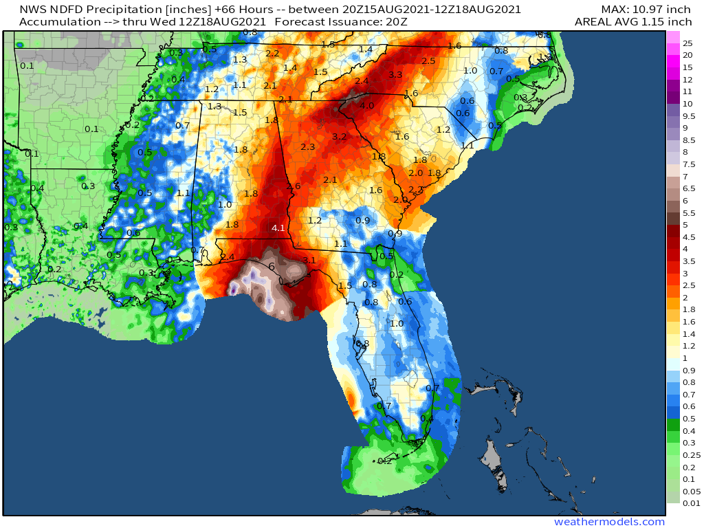
Rainfall remains the foremost threat with Fred. The heaviest rainfall of 3-5” with locally higher totals will fall along and east of the track, probably from roughly Destin to the eastern Big Bend. This rainfall, likely heaviest and most concentrated during the day on Monday, will bring the threat of flash flooding, especially for portions of the eastern Big Bend and north central Florida where river levels are already elevated. Rain totals of 2-4” will extend north through Tuesday into eastern Alabama and western Georgia, and scattered storms will bring another 1” or so of rain through mid-week for the Florida peninsula.
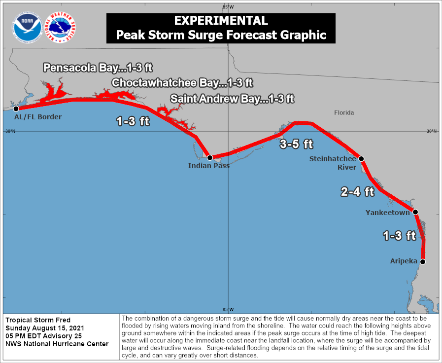
With Fred angling closer to Apalachee Bay, the expectation of an extended offshore fetch of southeast winds approaching gale force there increases the likely surge impacts on the Panhandle Coast, particularly on southeast-facing shores. A Storm Surge Warning is in effect between Indian Pass and Yankeetown, where 2-4’ of surge is likely, perhaps as soon as the morning high tide in many of these areas. A broader area of 1-3’ surge is probable elsewhere along and east of Fred’s track in the Panhandle and Big Bend.
Winds themselves are not the primary risk from Fred, but the general area from Destin east to St. Marks could certainly see peak gusts along the immediate coast into the lower to mid 50’s, particularly in squally bands Monday morning and afternoon. For inland areas including Tallahassee, occasional gusts into low-end tropical storm range are possible in squalls, especially near and just east of where the center eventually tracks. A widespread inland wind event is not expected, but some tree damage and local power outages are probable.
Finally, as always, keep a keen eye out for the threat of tornadoes embedded within Fred’s bands as it comes inland. This threat may extend well east of the center, so don’t be surprised if much of North Florida is under a Tornado Watch on Monday. Keep a means of receiving Tornado Warnings on hand through the day.
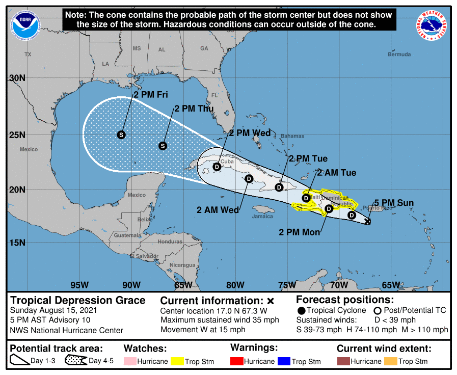
On a different note, Tropical Depression Grace has passed south of Puerto Rico and is approaching Hispaniola. Grace remains a poorly organized, low-end tropical storm and will be further disrupted by Hispaniola over the next 36 hours.
Grace’s lack of strengthening has resulted in a track south of earlier NHC forecasts, as it followed east-to-west low-level trade winds. The good news is that Grace is likely to pass well south of Florida in around 3 days, with minimal impacts on the state. Assuming it survives, Grace may find a more favorable environment for intensification in the south central Gulf, and could be a threat to northern Mexico and the western half of the U.S. Gulf Coast. But Grace will be a non-issue for Florida.
Overall, Fred is not a top-tier tropical threat to North Florida, and overall impacts on the area will likely be measured, particularly away from the immediate coast. Nevertheless, closely monitor the forecast through the day on Monday to avoid unnecessary risks and take any actions necessary to protect life and property as Fred comes rollin’, rollin’, rollin’, rollin’ through the Panhandle. Keep watching the skies.
Next update: We will have a live landfall forecast video out by the early afternoon tomorrow. This will be broadcast live via Facebook, and also be posted here as well.


