Tropical Storm Nicole Florida Impacts Forecast for November 9th
A timeline of what each region of Florida can expect from Nicole in surge, wind, and rain impacts.
This post may be shared freely. If you are a free subscriber, please consider a paid subscription to support the Hurricane Watch. You’ll get supporter-exclusive, Florida-focused tropical briefings, plus full coverage of every U.S. hurricane threat, and the ability to comment on posts, ask questions, and get answers from a tropical meteorologist.
Update (10:30 p.m.): The live forecast video replay is below. Forecast starts at 4:00.
Thanks for reading and stay safe.
Nicole is launching its amphibious assault on Florida, and dangerous surge, wind, and heavy rainfall will continue to overspread most of the state through Thursday and into early Friday.
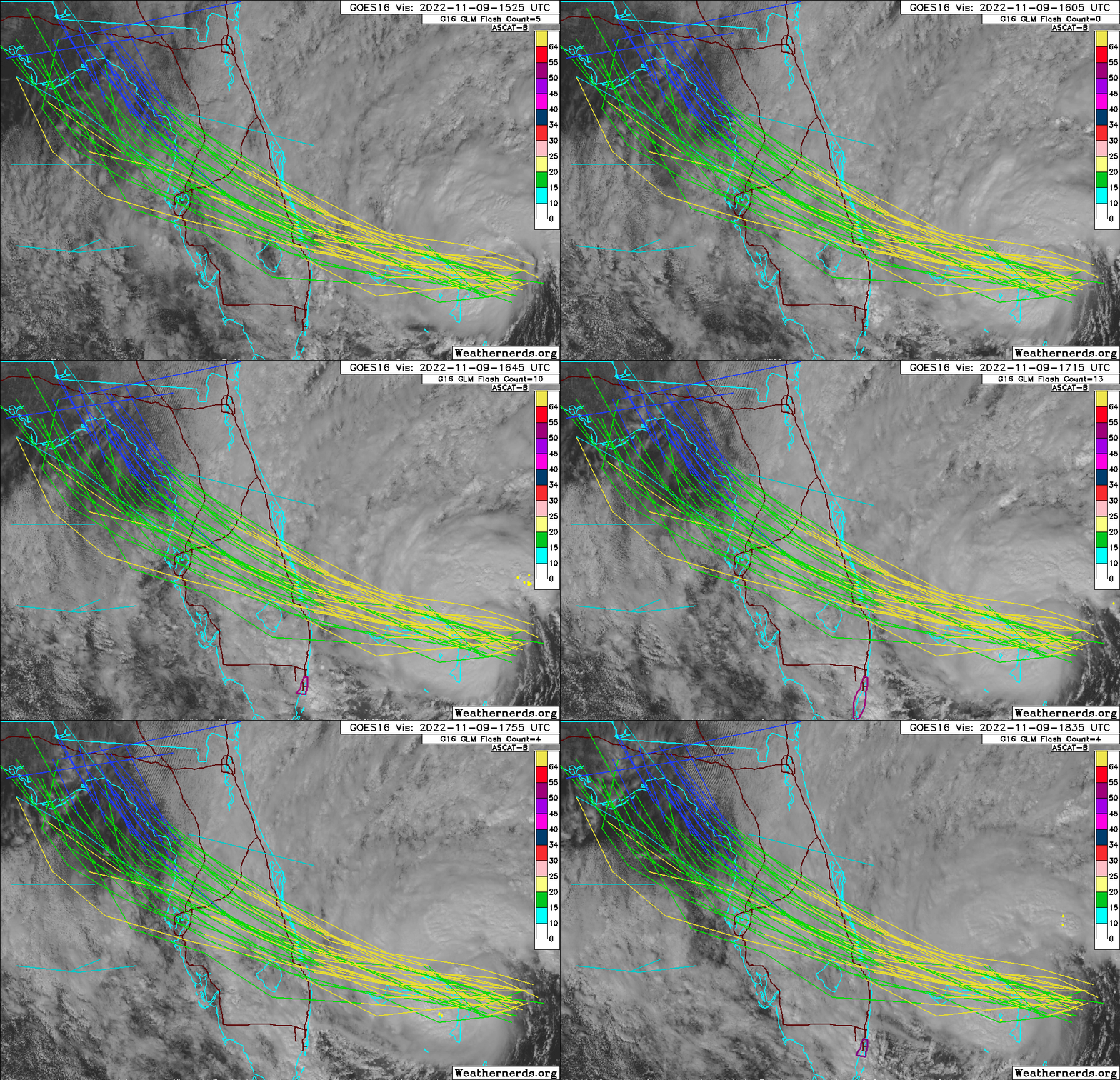
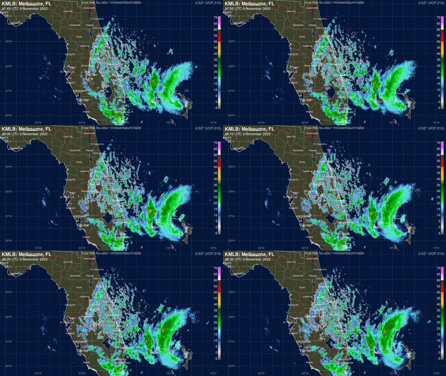
As of Wednesday afternoon, Nicole is getting better organized, with deep convection ringing a ragged eye. Maximum sustained winds are just shy of hurricane strength at 70 mph, and Nicole is expected to reach Category 1 intensity prior to landfall.
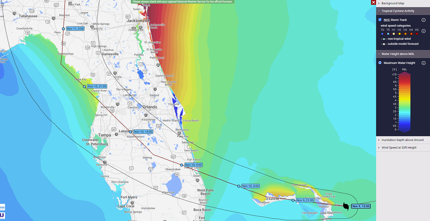
Nicole’s southward jaunt has ended, and a west to west-northwest motion will bring the storm’s center onshore somewhere between Melbourne and Jupiter very early on Thursday and into west Central Florida by mid-day Thursday. With a slight increase in expected forward speed, Nicole’s path has nudged a bit farther west since yesterday. It is now probable that the storm will tick into the far northeastern Gulf Thursday afternoon before curving north across the eastern Panhandle Thursday night.
With this general scenario likely to play out (plus or minus an Apalachee Bay-sized margin of error), let’s look at what impacts Florida can expect from Nicole, region-by-region:
Florida Panhandle, including Tallahassee, Madison, Apalachicola, Marianna, and Steinhatchee:
The aforementioned bump west in Nicole’s track on Thursday makes the biggest difference in impacts in the eastern Panhandle. In particular, a center path that moves across Apalachee Bay rather than scrapes along the Nature Coast results in far more coastal flood potential along and east of the track. Should this occur, onshore winds (out of the south and southwest) Thursday night and early Friday could drive 3 to 5 feet of storm surge across roughly the eastern half of Apalachee Bay, with much less coastal flooding west of the center where winds remain offshore or alongshore. As such, a Storm Surge Warning is in effect west to Ochlockonee Bay, with a Storm Surge Watch extending to Cape San Blas.
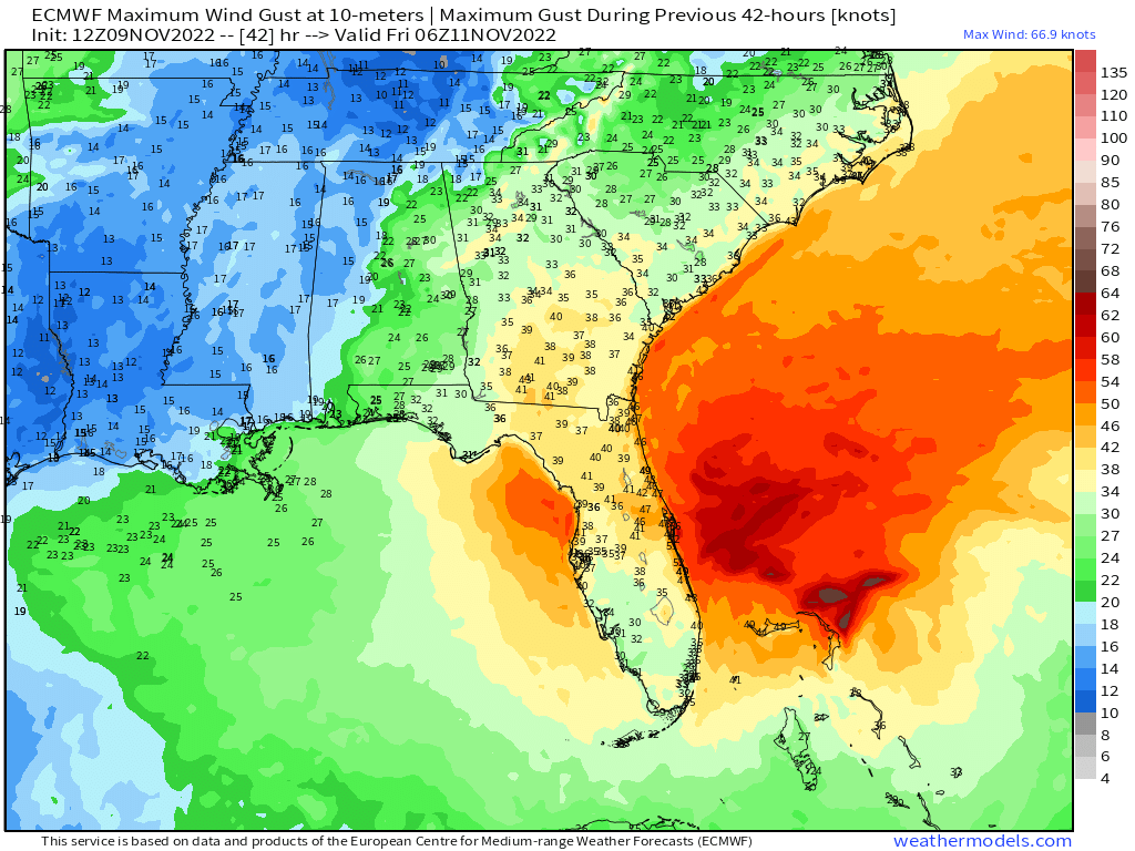
Expected rain and wind impacts are also on the rise for the eastern Panhandle. While water temperatures in the northeastern Gulf are too mild to allow re-strengthening on Thursday and the storm will struggle to generate deep convection as it approaches the Big Bend, Nicole’s very broad windfield is still expected to bring sustained tropical-storm-force winds to the coast by mid-day Thursday, with tropical-storm-force wind gusts overspreading inland areas Thursday afternoon and continuing into early Friday morning. These wind gusts, likely topping out at 35 to 50 mph inland, will cause tree damage and power outages. A Tropical Storm Warning is in effect east of the Apalachicola River, including inland areas.
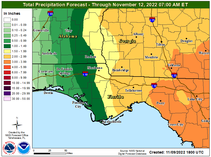
The good news is much-needed rainfall for the Panhandle is part and parcel of Nicole’s mishigas. Outer bands will overspread the Panhandle from east to west on Thursday morning, with the heaviest rainfall Thursday evening and showers clearing by Friday mid-morning. Expect general storm totals of 1.5-3” and locally higher east of the Apalachicola River, heaviest farther east, with totals quickly diminishing west of the river. Not a drought breaker, but it will help.
North Central Florida, including Jacksonville, Lake City, St. Augustine, Gainesville, Daytona Beach, and Ocala:
North Central Florida already has seen significant impacts from Nicole through Wednesday afternoon, including significant coastal flooding overwashing A1A, and tropical-storm-force wind gusts. Rain and wind impacts will ramp up into early Thursday, with the worst conditions expected between the overnight hours and Thursday afternoon for most of this region.
Coastal flooding in northeast Florida and along the Saint Johns River basin continues to be the primary threat from Nicole, where Storm Surge Warnings are in effect. Peak storm surge of 3 to 5 feet above normal high water is expected, likely topping out with Thursday morning’s high tide. While North Central Florida will not see the highest winds associated with Nicole’s core, Tropical Storm Warnings are in effect for the entire region, and coastal gusts will likely peak early Thursday in the 50s in northeast Florida and the 60s or above in Volusia County. Peak inland wind gusts from 40 to 50 mph are probable inland through the day on Thursday.
Localized flash flooding is also a concern in North Central Florida, where the heaviest rainfall is expected Thursday morning and intermittent bands will linger through early Friday afternoon. Look for totals of 2-4” in this region, higher along the coast. A few tornadoes are also possible Thursday in outer bands.
Central and South Central Florida, including Port St. Lucie, Melbourne, Orlando, Lakeland, and Tampa:
East Central Florida is expected to bear the brunt of Nicole. The section of coastline between Cape Canaveral and Port St. Lucie, where rain, wind, and surge impacts are already underway, will likely see the greatest coastal flooding associated with high tides Wednesday evening and Thursday morning. Peak surge values of 3 to 5 feet are likely, though higher local values are possible, particularly where the northern eyewall (or messy eyewall-like feature) crosses the coast early Thursday.
The northern or western eyewall is also where potential hurricane-force winds are most possible, though wind gusts of 75 mph or greater are likely to be limited to the coast or areas immediately inland even within the eyewall. Coastal areas that do not see the eyewall in this region will likely see top gusts in the higher register of the tropical-storm-force range. Winds along the coast should be declining by mid-morning Thursday.
Nicole is not likely to be especially efficient at bringing winds inland. The highest gusts onshore of 45 to 60 mph are most probable in Brevard, Volusia, Osceola, Orange, and Seminole Counties Thursday morning as the northern portion of Nicole’s core moves west-northwest across the peninsula. Peak wind gusts of 35 to 50 mph are possible in West Central Florida late Thursday morning into Thursday afternoon, mostly north of Tampa, with low-end tropical-storm-force gusts also occurring on the western Gulf Coast between Thursday morning and evening. Should Nicole move into the northeast Gulf, 3 to 5 feet of storm surge would be possible on the Nature Coast as winds flip onshore Thursday afternoon. Storm Surge Warnings are in effect north of the Anclote River.
Finally, heavier and steadier rainfall developing moving in from east to west Wednesday evening and continuing overnight will begin to clear East Central Florida by mid-day Thursday and West Central Florida by Thursday evening. Most likely storm totals are 3-6” east and 2-4” west.
South Florida, from West Palm Beach to Charlotte Harbor and south:
With this region seeing the center track north of it overnight Wednesday into Thursday, impacts will be greater in the northern end of the region than the southern end. Peak surge in Palm Beach County of 2 to 4 feet associated with the next two high tides will ease by mid-day Thursday. No significant surge is expected in Southwest Florida, thankfully.
Low-end tropical-storm-force wind gusts along the Southeast Florida coast will also diminish overnight as winds flip to offshore flow, and inland wind gusts in the northern end of this region may peak around 40 mph between midnight and noon on Thursday. Rain totals in South Florida will range from around 1” southwest to 3” or so in Palm Beach County, with heavier precip tapering off Thursday morning and occasional bands ending Thursday evening.
In general, Florida will see a second round of widespread damaging impacts from a tropical system in just six weeks. Nicole will not compare to Ian, but it will be impactful in its own right, especially in terms of coastal flooding. Longer term, the good news is that a weekend cold front should put an end to our extended tropical season once and for all; the bad news is before it gets cold, we must get Nicole’d. Once more unto the breach, my friends. Stay safe, and keep watching the skies.
Next update: Video forecast tonight, situation update tomorrow morning.


![[Image of cumulative wind history] [Image of cumulative wind history]](https://substackcdn.com/image/fetch/w_1456,c_limit,f_auto,q_auto:good,fl_progressive:steep/https%3A%2F%2Fbucketeer-e05bbc84-baa3-437e-9518-adb32be77984.s3.amazonaws.com%2Fpublic%2Fimages%2F28a9fc6b-8f00-4b64-bf44-ffe6f9ff57fc_897x736.png)
