Tropical Storm Nicole Florida Impacts Forecast for November 8th
Nicole will make landfall as a hurricane by early Thursday. These are the surge, wind, rain, and tornado impacts Florida can expect.
This post may be shared freely. If you are a free subscriber, please consider a paid subscription to support the Hurricane Watch. You’ll get supporter-exclusive, Florida-focused tropical briefings, plus full coverage of every U.S. hurricane threat, and the ability to comment on posts, ask questions, and get answers from a tropical meteorologist.
Update (10 p.m.): Video discussion added below.
Tropical Storm Nicole is strengthening as it approaches the Bahamas, and Florida’s East Coast is likely to see the first hurricane landfall from the east since 2005 by early Thursday morning. Widespread coastal flooding, tropical-storm-force winds, and heavy rain will begin overnight Tuesday into Wednesday in eastern Florida, with impacts reaching northwest to the eastern Panhandle into Thursday.
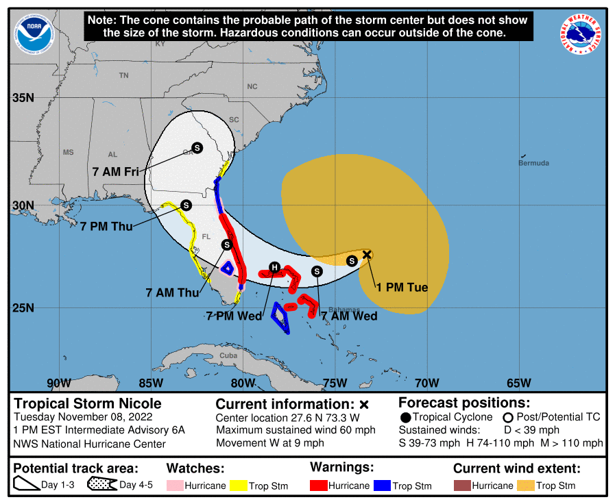
As of Tuesday afternoon, the center of Nicole is located around 400 miles east of Melbourne, moving west at about 10 mph. Over the next 12 to 24 hours, Nicole will dip southwestward in response to powerful ridging over the Southeast U.S., before a west and west-northwest motion resumes Wednesday.
On this track, Nicole will intercept the Florida coastline somewhere between Brevard and Palm Beach Counties overnight Wednesday into Thursday. Guidance is in good agreement that Nicole’s track will bend northwest and then north post-landfall, curling through the Big Bend or north Central Florida Thursday evening. This motion is a little faster than yesterday’s forecast, and inclement weather should clear Florida by noon Friday.

Nicole’s structure has evolved since yesterday in a way indicating a bit more intensification is likely prior to landfall. Nicole shed its erstwhile subtropical designation on Tuesday morning, and is now a tropical storm with maximum sustained winds as of 1 p.m. of 60 mph. This change is due to the development a nascent core of deep convection, which is impressively wrapping around the center of circulation this afternoon, indicative of further strengthening in the near future. While Nicole still has a massive broader circulation, these more intense storms are allowing Nicole’s strongest winds to both increase and to shift closer to the center. This means that Category 1 hurricane intensity at landfall is the most likely outcome, with tropical storm strength persisting into early Friday.
It should be emphasized that Nicole is not Ian. It won’t suddenly become a Category 3 hurricane on final approach to Florida. However, every hurricane is unhappy in its own way, and Nicole’s size and strength will result in broad impacts from all four hurricane hazards—surge, wind, rain, and tornadoes. Let’s go through each of those hazards to get a complete picture of the threat Nicole poses to Florida:
Storm Surge
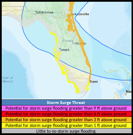
Coastal flooding and surge along Florida’s East Coast continue to be the main concern from Nicole. With several days’ worth of northeasterly and easterly fetch through Thursday, the combined action of wind-driven surge, higher-than-usual tides, and offshore seas of up to 20’ will lead to significant and long-lasting inundation of low-lying areas near the Atlantic coast and St. Johns River system.
Storm Surge Warnings are up for most of Florida’s East Coast, as well as coastal Georgia. In this region, peak surge over average high tide is expected to be on the order of 3 to 5 feet, perhaps higher due to local geography. Highest water is expected with Thursday morning’s high tide. Additionally, Storm Surge Watches are in place for southeast Florida and for the west central Florida coast from north of Tampa to Cedar Key. A surge materializing on portions of the Gulf Coast is dependent on Nicole’s precise track on Thursday. However, a 2-4’ surge is possible in the Nature Coast if a strong onshore flow occurs. Mostly offshore or along-shore flow are likely in Apalachee Bay, but keep an eye on the forecast.
Wind
Nicole’s developing more intense core notwithstanding, tropical-storm-force winds continue to cover a hefty chunk of the southwest Atlantic, extending over 350 miles northwest and 275 miles northeast of Nicole’s center. Near-tropical-storm-force gusts are already developing up and down the Florida East Coast, and peak gusts along and near the coast outside of the more convective portion of Nicole will be 50 mph or so from Wednesday into early Thursday.
With the center of Nicole expected to reach land somewhere between Cape Canaveral and Palm Beach, a smaller area of coastal hurricane-force winds is possible north of the landfall point. Hurricane Warnings are up, and Volusia, Brevard, Indian River, St. Lucie, and Martin Counties are at the greatest risk of these elevated wind impacts. Inland portions of East Central, West Central, and North Central Florida also likely to see low-to-moderate tropical-storm-force wind gusts from late Wednesday through Thursday as Nicole’s center tracks onshore. Low-end tropical storm gusts may extend west into the eastern Panhandle and Apalachee Bay Thursday evening depending on the exact track of Nicole, and Tropical Storm Watches are in effect from Apalachee Bay to Charlotte Harbor.
Rain
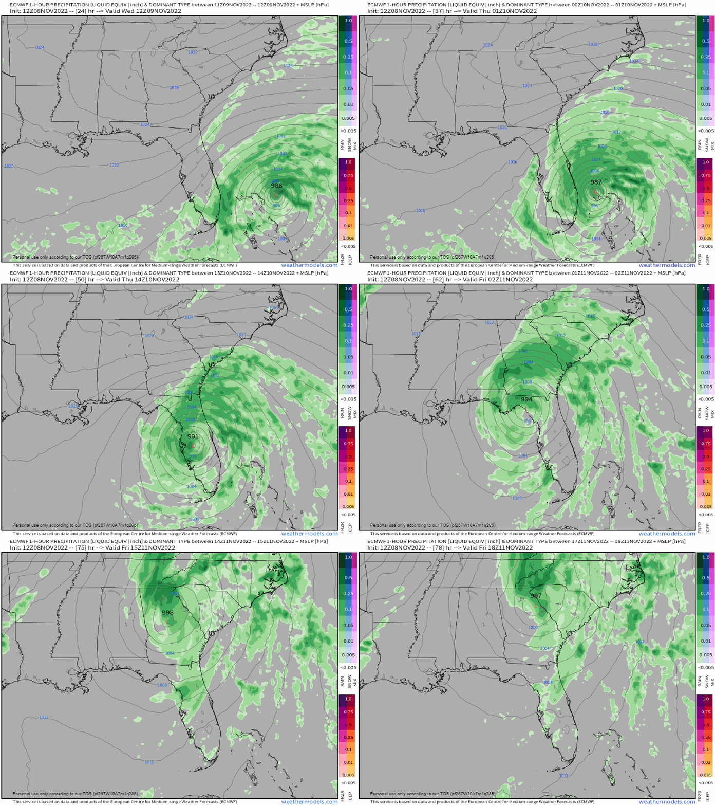
Nicole is expected to keep a 15 to 20 mph canter as it moves across Florida on Thursday, which will limit though not eliminate the threat of flooding rainfall. Frequent showers will begin Wednesday morning in southeast and east central Florida, Wednesday evening in northeast and west central Florida, and Thursday morning in the Big Bend, with the heaviest rainfall pushing northwest across the state between roughly midnight Thursday and midnight Friday.
The heaviest rainfall totals of 3-6” with local maxima of 8” are expected across the eastern half of the peninsula, where the highest risks of urban flooding and river flooding issues reside. A general 2-4” is expected for west central and north-central Florida. In the eastern Panhandle, Nicole’s slightly faster motion means getting some (beneficial) rainfall from Nicole is looking more likely; expect totals of 1-2” in the Big Bend, heaviest east. Central Time Zone Florida should see less than 1”, with many in the western Panhandle seeing a cool 0”.
Tornadoes
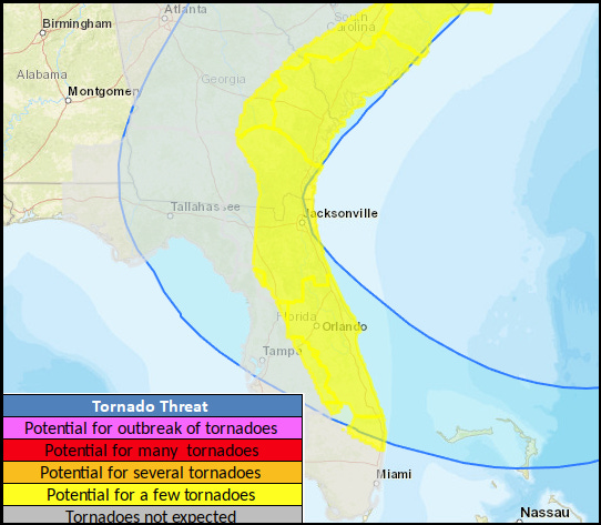
There is a slight risk of tornadoes associated with outer bands of Nicole, particularly in east central and northeast Florida Wednesday afternoon through Thursday morning. While a major tornado outbreak is not anticipated, rainband tornadoes spin up quickly, so have a way of receiving NWS warnings on hand.
Overall, don’t let the fact that Nicole is an exceptionally bizarre threat for this time of year prevent you from taking the necessary precautions. It is weird, but it is also happening. The reality is reality is going to bite for the next several days, and you need to use the rest of today to make any needed preparations. I’ll be continuing to track all Nicole has to offer with updates and videos through the storm. Keep your wits about you and keep watching the skies.


THANK YOU SO MUCH for a very detailed report. This helps us to know what to expect where and to prepare appropriately.
Looking ahead for your next report to see if things you point out here have changed.
You are the BOMB!