Tropical Storm Helene Morning Briefing for September 25th
Helene closes in on hurricane intensity as it nears the Gulf, on track for a late Thursday landfall in the eastern Florida Panhandle.
WeatherTiger’s Hurricane Watch is a reader-supported publication. Paid subscribers get daily tropical bulletins, weekly columns, coverage of every hurricane threat, the ability to comment on posts and ask questions, and more. Paid supporters will also receive a subscriber-exclusive morning forecast briefing through the threat from Helene.
This post is outdated! Click the link below for the latest.
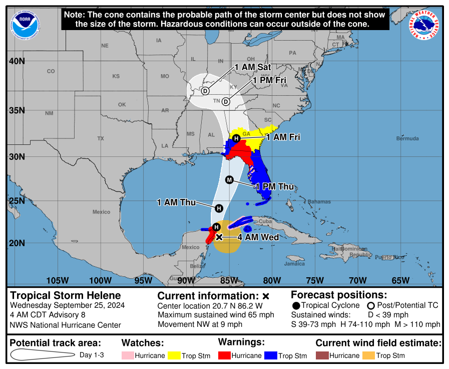
Helene has intensified to a strong tropical storm this morning while moving towards the southern Gulf of Mexico, and its expected path has shifted slightly west overnight. NHC track and intensity forecasts have changed only slightly overnight, bringing a major hurricane into the eastern Panhandle tomorrow evening. With the onset of widespread dangerous condition early tomorrow, you have today to prepare for what will be an unprecedentedly large and powerful hurricane strike on North Florida with severe impacts occurring all along the Florida Gulf Coast, where Hurricane and Storm Surge Warnings remain in effect. (See cone below for wind warnings.)
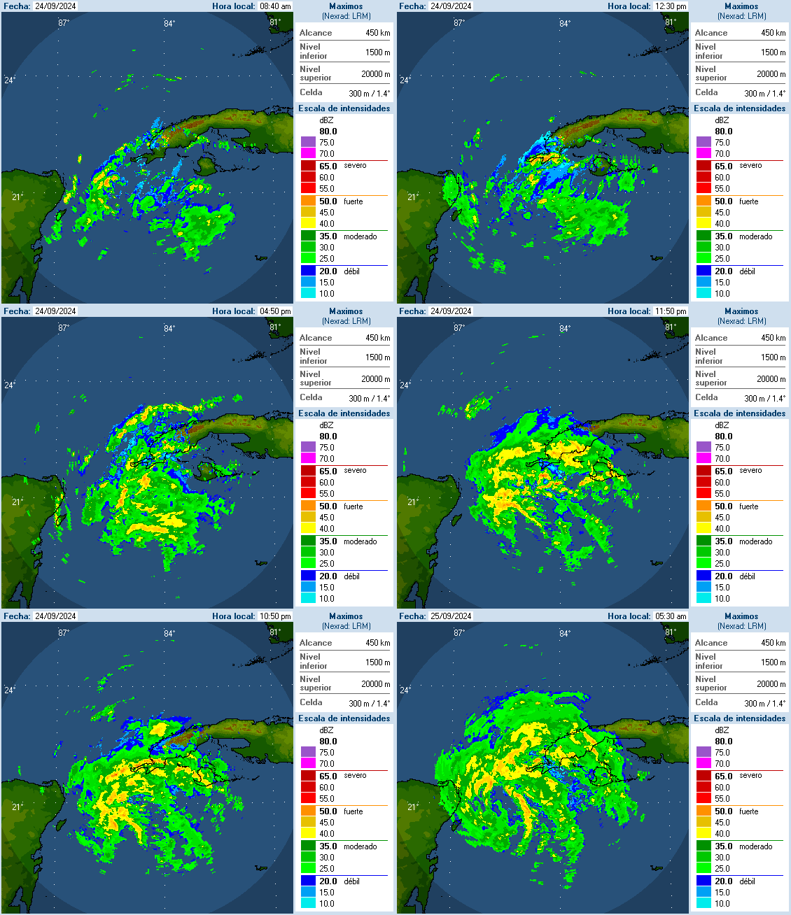
As of the NHC’s 5 a.m. advisory, Tropical Storm Helene is located about 650 miles south of Tallahassee, moving northwest at about 10 mph. Helene’s movement over the last day has followed the NHC forecast track closely, with the expected bend north evident on satellite imagery and on radar out of western Cuba (below) and Cancun. Helene is not going to move over land and will instead shoot through the Yucatan Channel this morning and enter the southern Gulf of Mexico. That’s bad news, as we were hoping for some land interaction to slow down strengthening today.
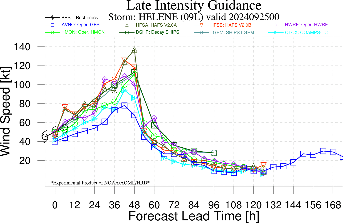
Maximum sustained winds have increased to 65 mph overnight, so Helene is on the cusp of Category 1 hurricane intensity. Two Hurricane Hunter planes are enroute to check Helene’s intensity and structure, and we haven’t had fresh aircraft obs for a few hours. Deep convection has wrapped around the center overnight, and everything I’m seeing this morning on satellite and radar suggests the storm is strengthening, if not rapidly for now, at least steadily. We’ll see if the Hurricane Hunters find that Helene is a hurricane later this morning. In the meantime, NHC intensity forecast continues to call for Helene to intensify to a Category 3 hurricane by Thursday morning, and maintain that intensity to landfall. Peak intensity at Category 4 strength remains a possibility indicated by the HAFS hurricane models. In general, Category 2 to 4 strength at landfall remains probable, though as I’ve mentioned before, “category” is a misleading way to think about Helene and its myriad threats.
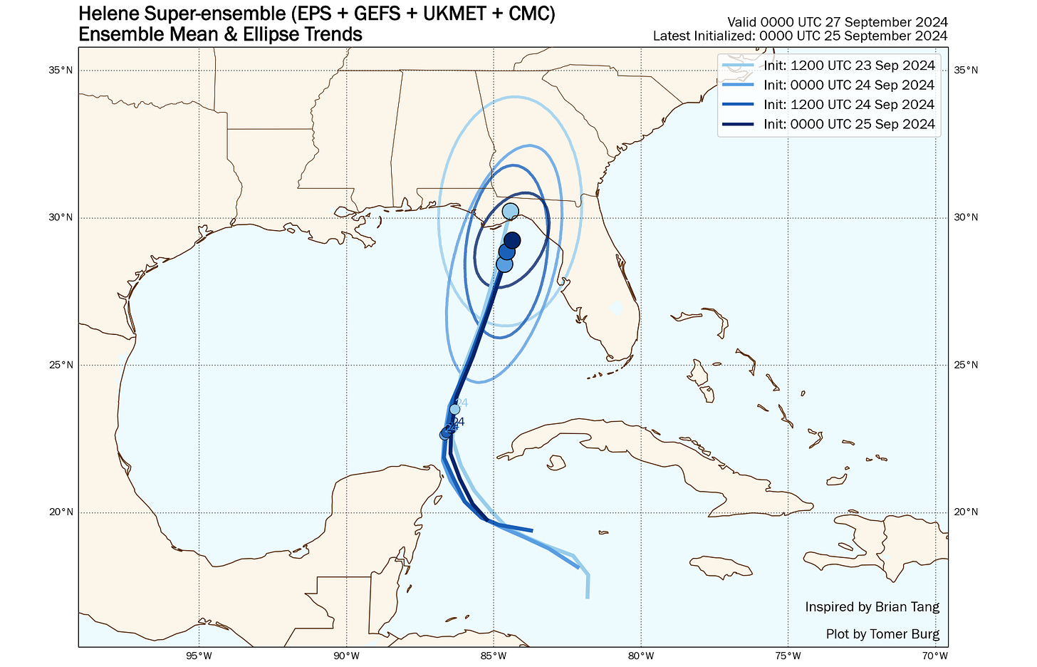
The NHC track forecast was steady overnight, with the 5 a.m. advisory bringing Helene’s center to the coastline in western Apalachee Bay, a slight shift of a few miles. Overnight model guidance as a whole has not changed much at all other than continuing to reduce the spread between different models and ensembles, narrowing the range of likely outcomes. In other words, the noose is getting tight as run-to-run confidence on a north-northeast track across the eastern Gulf to an Apalachee Bay landfall on Thursday night increases.
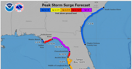
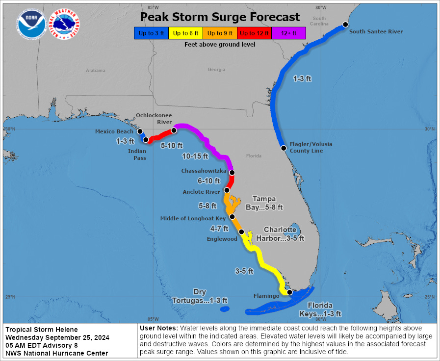
I’m going to talk more specifically about impacts later today, but suffice to say they will be widespread and severe across Florida, not just areas close to the landfall point. Life-threatening storm surge of 10-15’+ in Apalachee Bay will submerge much of the Big Bend and eastern Panhandle’s low-lying coastal counties, where mandatory evacuations are in effect. This would by far be the worst surge in recorded history in Apalachee Bay, exceeding Michael’s surge and that of the much smaller Idalia in Apalachee Bay and the Nature Coast. Significant surge farther south across the Florida Gulf Coast, including 5-8’ for Tampa Bay, is also a major threat to life and property.
As far as wind impacts go, the difference between damaging and potentially catastrophic winds for your local impact is whether or not the core/eyewall of Helene moves over you, which in this case may be 60 miles wide or so, narrowing inland though not particularly quickly due to Helene’s expected 20 mph+ forward speed on impact. It’s too early to know exactly who will get the core, but if you do, expect damaging inland wind gusts of 80-100+ mph. For Tallahassee, that would cause damage exceeding Hermine or Michael. On the coast, that’s where the NWS wind threat product below is showing the highest potential of major hurricane (111 mph or higher) gusts. Right now, it’s not looking great for Tallahassee and the Big Bend, as we’re running out of time for the kind of bacon-saving east shift that kept the worst of Idalia and Debby to our southeast. Damaging winds will also extend well inland into south Georgia and south along the Florida Gulf Coast, as shown below.
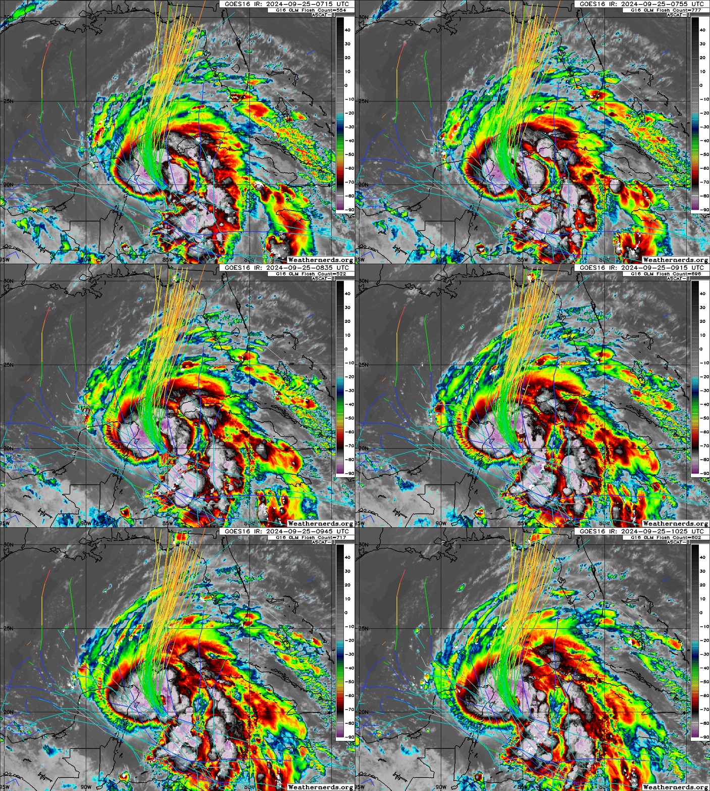
Overall, this is a bad trend for everyone in Florida, but especially the eastern Panhandle and Big Bend. With Helene following model and NHC guidance closely overnight (see infrared/GEFS tracks overlay below), avoiding land interaction, and appearing structurally poised for intensification, catastrophic storm surge as well as destructive winds are increasingly likely in the areas under Hurricane and Storm Surge Warnings. With only some widely scattered storms expected in Florida on Wednesday, weather will be generally good for preparations and evacuation, as your situation requires. IF YOU HAVE AN EVACUATION ORDER, GO TODAY. Weather conditions will go downhill tomorrow.
Back around 2 p.m. with a full analysis of wind, surge, and rain impacts expectations and at 9 p.m. this evening with a live forecast video. Keep watching the skies.




Thank you for your dedicated service to our communities. Wishing you and your family a safe ride through this event. God bless.
East Central Florida's thoughts and prayers are with all of you up there. Stay safe everyone!